The Harmed Success Stories Concepts How To What Is Commentary
Fayette County Marcellus Shale Permits 2/6/17 - 2/19/17
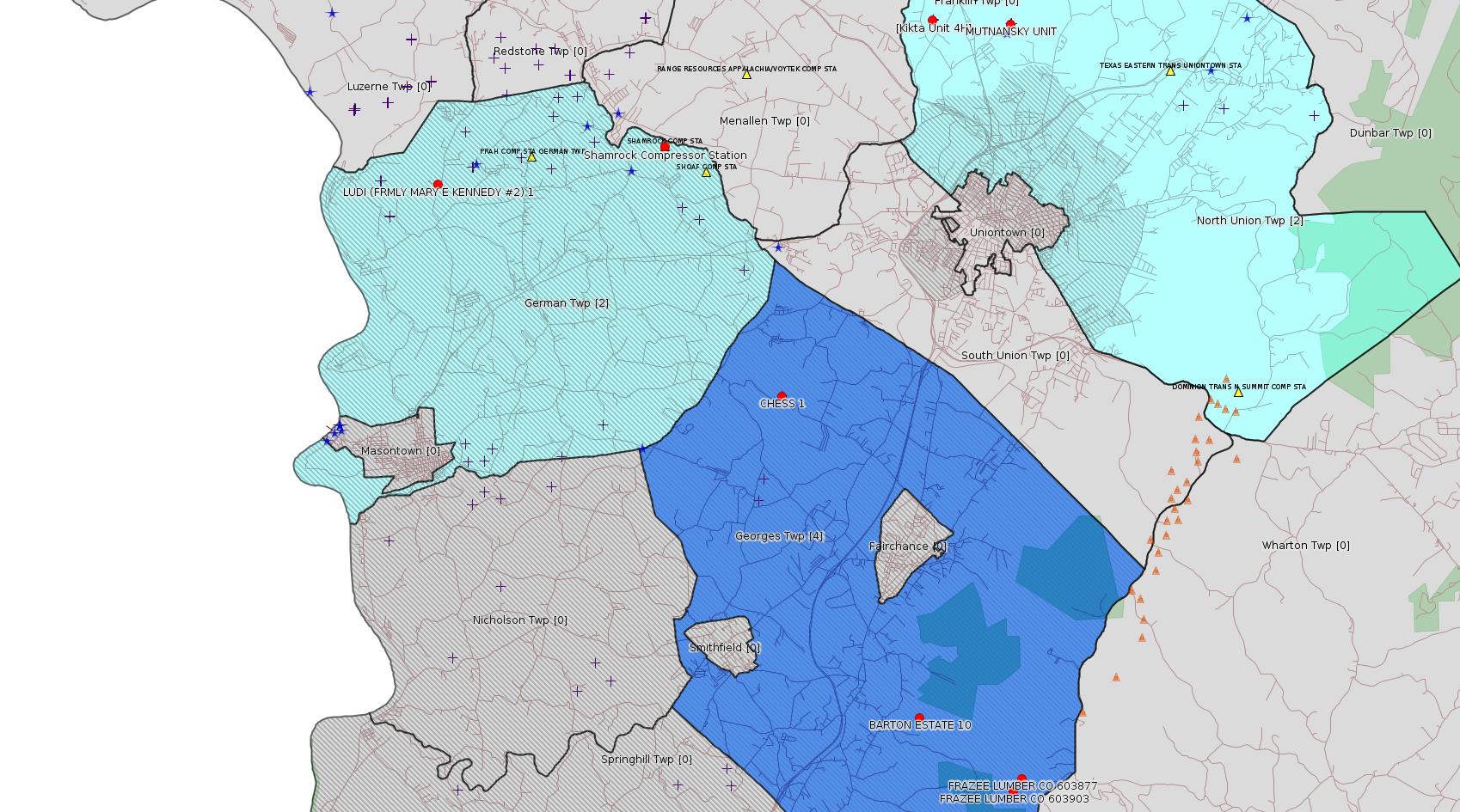
Click the map to enlarge
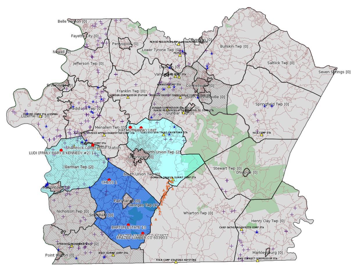
Map
Key
Red dots: items in this permit list with an exact location.
Blue stars: Marcellus Gas Well Water Sources.
Municipality shading: number of "facilities", with each well counting separately
(includes the red dots):
Red dots: items in this permit list with an exact location.
Blue stars: Marcellus Gas Well Water Sources.
Municipality shading: number of "facilities", with each well counting separately
(includes the red dots):
gray: 0
pale turquoise: 1
turquoise: 2
pale blue: 3
middle blue: 4
dark blue: 6
dark purple: 9
purple: 19
(Color coding may differ from one issue to the next.)
(Note if a project spans multiple municipalities -- e.g. a pipeline -- it will show in the count for each municipality.)
The number of facilities also follows the municipality name in brackets.
Municipality counts are based on the way the permit is listed by DEP; DEP has been known to get a municipality wrong.
Locations in brackets identify a precise location used to locate a surrogate for the actual site being permitted (e.g. locating a well pad or pipeline by the known location of a well.) Locations labeled beginning with "~" and ending in "[?]" are approximate and speculative based on inferences using on-line property and lease records. These are marked in the text as "[Approximate, Speculative]
Cross-hatching: Environmental Justice Areas
Yellow triangles: Compressor Stations
Orange triangles: Storage Field Wells (currently Dominion North Summit Storage Field)
Crosses: Unconventional well permits (may not have been drilled)
Green: "Natural areas", e.g. state game lands, state forests
Yellow triangles: Compressor Stations
Orange triangles: Storage Field Wells (currently Dominion North Summit Storage Field)
Crosses: Unconventional well permits (may not have been drilled)
Green: "Natural areas", e.g. state game lands, state forests
More Maps
 |
Source: Pennsylvania Bulletin
[No Activity]
-------------------------
Source: eNOTICE (+ PA Oil and Gas Mapping, Well Pad Report) Please see the Disclaimer below regarding Parcel Id data.
[Conventional Well:]
Authorization ID: 1169001
Permit number: 051-00127
Site: FRAZEE LUMBER 603877 WELL
Client: EQT PRODUCTION CO
Authorization type: Well Plugging Notice Intent to Plug Single Well
Application type: New
Authorization is for: FACILITY
Date received: 02/08/2017
Status: Pending
Sub-Facility ID Sub-Facility Name Description
56087 FRAZEE LUMBER CO 603877 Well
<http://www.ahs.dep.pa.gov/eFACTSWeb/searchResults_singleAuth.aspx?AuthID=1169001>
Location: 39.770006,-79.719653 <http://osm.org/go/ZWpg~3uJ--?m=>
Municipalities: Georges Twp [an Environmental Justice Area]
Presumed Parcel Id: 14370013
Well Details Report Record:
<https://www.paoilandgasreporting.state.pa.us/publicreports/Modules/WellDetails/WellDetails.aspx?PermitNumber=051-00127>
[See Notes.]
[Conventional Well:]
Authorization ID: 1169036
Permit number: 051-20737
Site: BARTON ESTATE 10 WELL
Client: EQT PRODUCTION CO
Authorization type: Well Plugging Notice Intent to Plug Single Well
Application type: New
Authorization is for: FACILITY
Date received: 02/02/2017
Status: Pending
Sub-Facility ID Sub-Facility Name Description
56914 BARTON ESTATE 10 Well
<http://www.ahs.dep.pa.gov/eFACTSWeb/searchResults_singleAuth.aspx?AuthID=1169036>
Location: 39.784419,-79.750471 <http://osm.org/go/ZWphk6Oo--?m=>
Municipalities: Georges Twp [an Environmental Justice Area]
Presumed Parcel Id: 14370013
Well Details Report Record:
<https://www.paoilandgasreporting.state.pa.us/publicreports/Modules/WellDetails/WellDetails.aspx?PermitNumber=051-20737>
[Conventional Well:]
Authorization ID: 1169044
Permit number: 051-00126
Site: FRAZEE LUMBER 603903 WELL
Client: EQT PRODUCTION CO
Authorization type: Well Plugging Notice Intent to Plug Single Well
Application type: New
Authorization is for: FACILITY
Date received: 02/08/2017
Status: Pending
Sub-Facility ID Sub-Facility Name Description
56086 FRAZEE LUMBER CO 603903 Well
<http://www.ahs.dep.pa.gov/eFACTSWeb/searchResults_singleAuth.aspx?AuthID=1169044>
Location: 39.766986,-79.722321 <http://osm.org/go/ZWpg~O_9--?m=>
Municipalities: Georges Twp [an Environmental Justice Area]
Presumed Parcel Id: 14370013
Well Details Report Record:
<https://www.paoilandgasreporting.state.pa.us/publicreports/Modules/WellDetails/WellDetails.aspx?PermitNumber=051-00126>
[Conventional Well:]
Authorization ID: 1170212
Permit number: 051-20371
Site: LUDI FORMERLY MARY E KENNEDY 1 OG WELL
Client: KENNEDY ALBERT A
Authorization type: Well Plugging Notice Intent to Plug Single Well
Application type: New
Authorization is for: FACILITY
Date received: 02/10/2017
Status: Pending
Sub-Facility ID Sub-Facility Name Description
56551 LUDI (FRMLY MARY E KENNEDY #2) 1 Well
<http://www.ahs.dep.pa.gov/eFACTSWeb/searchResults_singleAuth.aspx?AuthID=1170212>
Location: 39.910222,-79.893833 <http://osm.org/go/ZWpYrvF2--?m=>
Municipalities: German Twp [an Environmental Justice Area]
Presumed Parcel Id: 15110084
Well Details Report Record:
<https://www.paoilandgasreporting.state.pa.us/publicreports/Modules/WellDetails/WellDetails.aspx?PermitNumber=051-20371>
[Marcellus Well Pad Adjacency:]
Authorization ID: 1169862
Permit number: 26174001
Site: EARTH MOVERS PHILIPS MINE FIRE [Note "Phillips" is apparently misspelled -jr]
Client: WAMPUM HDWR CO
Authorization type: Blasting Activity Permit
Application type: New
Authorization is for: SITE
Date received: 02/15/2017
Status: Pending
<http://www.ahs.dep.pa.gov/eFACTSWeb/searchResults_singleAuth.aspx?AuthID=1169862>
Location [of Kikta Unit 4H, a well on the adjoining property]: 39.946967,-79.743442 <http://osm.org/go/ZWpxig3~--?m=>
Municipalities: North Union Twp, Uniontown [???: Uniontown here is probably incorrect -jr]
Presumed Parcel Id: 25060026
Well Details Report Record (Kikta 4H):
<https://www.paoilandgasreporting.state.pa.us/publicreports/Modules/WellDetails/WellDetails.aspx?PermitNumber=051-24471>
[See Notes from the 11/15/15 issue for more information about the association of the Phillips Mine Fire and the Kikta well pad.]
Authorization ID: 1170071
Permit number: 26-00588A
Site: SHAMROCK COMP STA
Client: LAUREL MTN MIDSTREAM OPR LLC
Authorization type: Major Facility Plan Approval New Facility Review Prevention of Significant Deterioration
Application type: Extension
Authorization is for: FACILITY
Date received: 01/31/2017
Status: Pending
<http://www.ahs.dep.pa.gov/eFACTSWeb/searchResults_singleAuth.aspx?AuthID=1170071>
Location: 39.918333,-79.825 <http://osm.org/go/ZWpasXGm--?m=>
Municipalities: German Twp [an Environmental Justice Area]
Parcel ID: 15140026
Authorization ID: 1170077
Permit number: 26-00588
Site: SHAMROCK COMP STA
Client: LAUREL MTN MIDSTREAM OPR LLC
Authorization type: Minor Facility Plan Approval New Source Performance Std
Application type: Extension
Authorization is for: FACILITY
Date received: 01/31/2017
Status: Pending
<http://www.ahs.dep.pa.gov/eFACTSWeb/searchResults_singleAuth.aspx?AuthID=1170077>
Authorization ID: 1164426
Permit number: 051-24525
Site: CHESS 1H ESCGP-EXPEDITED
Client: BURNETT OIL CO INC
Authorization type: Drill & Operate Well Permit
Application type: Renewal
Authorization is for: FACILITY
Date received: 10/06/2016
Status: Pending
<http://www.ahs.dep.pa.gov/eFACTSWeb/searchResults_singleAuth.aspx?AuthID=1164426>
Location: 39.859844,-79.7907 <http://osm.org/go/ZWplCMCe--?m=>
Municipalities, Georges Twp [an Environmental Justice Area]
Parcel Id: 14060098
Farm Name: Chess 1
Conservation Well: Y
Unconventional Well: N
Well Configuration: Vertical Well
Full 2014 Renewal Permit:
<http://www.depgis.state.pa.us/pdfHandler/pdFHandler.ashx?Doc=MTk1OTAx&ext=PDF>
Full 2015 Renewal Permit:
<http://www.depgis.state.pa.us/pdfHandler/pdFHandler.ashx?Doc=MzIyMzgz&ext=PDF>
[See Notes from the 1/8/17 issue.]
-------------------------
Source: DEP Oil and Gas Compliance Report
OPERATOR: CHEVRON APPALACHIA LLC
INSPECTION_ID: 2560457
INSPECTION_DATE: 01/27/2017
INSPECTION_TYPE: Routine/Complete Inspection
API_PERMIT: 051-24420
FARM_NAME: MUTNANSKY UNIT 9H
UNCONVENTIONAL: Y
SITE_ID: 743896
SITE_NAME: MUTNANSKY UNIT 12H OG WELL
FACILITY_TYPE: Oil & Gas Location
INSPECTION_CATEGORY: Primary Facility
REGION: EP DOGO SWDO Dstr Off
COUNTY: Fayette
MUNICIPALITY: North Union Twp
INSPECTOR: NAJEWICZ, JUSTIN
INSPECTION_RESULT_DESCRIPTION: No Violations Noted
INSPECTION_COMMENT: "On 01/27/17 at approximately 1300 hours I conducted a follow up inspection of the Mutnansky Unit. An NOV had been issued on 04/26/16 for 102.22(a). On the date of inspection the Act 9 sign was in place and all required documents were on site.
The majority of the site was well vegetated. The erosion noted in the NOV had been repaired, but erosion channels and what appeared to be tire tracks were present in the location of the repairs. BMPs were in place and sediment was not observed leaving the site. It is recommended that these issues be addressed once weather conditions permit.
"
[There is a similar record for MUTNANSKY UNIT 10H, 11H, and 12H.]
Well Pad Id: 148935
Site Name: MUTNANSKY UNIT 12H OG WELL
Site Id: 743896
Well Pad Location: 39.945839,-79.719947 <http://osm.org/go/ZWpw~3m2--?m=>
Wells on this pad:
051-24420 MUTNANSKY UNIT 9H
051-24421 MUTNANSKY UNIT 10H
051-24422 MUTNANSKY UNIT 11H
051-24423 MUTNANSKY UNIT 12H
-------------------------
Source: Reuters Commodities: Energy
Natural Gas
| Commodity | Exchange | Currency | Expire | Last Trade | Trade Time | Change | Open | Day's High | Day's Low |
|---|---|---|---|---|---|---|---|---|---|
| NATURAL
GAS CON1 Feb17 |
NYM | USD | 02/24 | 2.77 | 02/19 20:50 | -0.07 | 2.79 | 2.83 | 2.74 |
-------------------------
Notes:
The original permit for the conventional well FRAZEE LUMBER CO 603877 dates all the way back to 07/18/1986! It shows in eFACTS as "Well Registration Operated Well" -- this is a type of authorization DEP does not even issue any more.
------------------------
DEP defines an environmental justice area as "any census tract where 20 percent or more individuals live in poverty, and/or 30 percent or more of the population is minority". (See:
<http://www.portal.state.pa.us/portal/server.pt/community/pa_environmental_justice_areas/20991>
<http://www.portal.state.pa.us/portal/server.pt/community/dep_enhanced_public_participation_policy/20988>
). There are supposed to be enhanced public participation requirements for permits in environmental justice areas, but news of this actually ever happening is scarce. In Fayette County, the entirety of Springhill, Nicholson, German, and Georges Townships are environmental justice areas, as well as a large part of Dunbar Township. DEP's policy document on public participation guidelines for environmental justice areas is located here:
<http://www.elibrary.dep.state.pa.us/dsweb/Get/Version-48671/012-0501-002.pdf>
eNOTICE records are likely to list the same permit multiple times, as that permit moves through the DEP process.
Oil & Gas Wells designated with a site a number and the letter H typically designate horizontal wells.
-------------------------
Resources:
Pennsylvania Bulletin: <http://www.pabulletin.com/>
eNOTICE: <http://www.ahs2.dep.state.pa.
DEP Well Details Report: <https://www.paoilandgasreport
Well Details may not show any
information for new permits and will not show permits which have
not yet been issued. Lookup for Well Details is by permit number.
DEP Permits Issued Detail Report:
<http://www.depreportingservic
DEP SPUD (drilling started) Report:
<http://www.depreportingservices.state.pa.us/ReportServer/Pages/ReportViewer.aspx?/Oil_Gas/Spud_External_Data>
DEP Oil and Gas Compliance Report:
<http://www.depreportingservices.state.pa.us/ReportServer/Pages/ReportViewer.aspx?/Oil_Gas/OG_Compliance>
DEP PA Oil & Gas Mapping:
<http://www.depgis.state.pa.us/PaOilAndGasMapping>
DEP Oil and Gas Electronic Notifications
<http://www.depreportingservices.state.pa.us/ReportServer?/Oil_Gas/OG_Notifications>
DEP Oil and Gas Well Pad Report
<http://www.depreportingservices.state.pa.us/ReportServer?/Oil_Gas/Well_Pads>
Fayette County Assessment Office Search For Tax Records:
<http://property.co.fayette.pa.us/search.aspx>
Pennsylvania Spatial Data Access:
<http://www.pasda.psu.edu/default.asp>
DEP Spatial Data Repository:
<ftp://www.pasda.psu.edu/pub/pasda/dep/>
National Response Center:
<http://www.nrc.uscg.mil/>
EPA-Echo: <http://www.epa-echo.gov/echo/
FERC citizen involvement: <http://www.ferc.gov/for-citiz
To receive E-mail notification of
all documents filed in a FERC docket, see:
<http://www.ferc.gov/docs-filing/esubscription.asp >
<http://www.ferc.gov/docs-fili
Follow the directions and enter the docket number to subscribe to.
Township Supervisors receive information regarding Erosion & Sedimentation permits, and these records may be reviewable at township municipal offices.
DEP permits are reviewable through the File Review process, for application to do file review see: <http://www.portal.state.pa.us/portal/server.pt/community/southwest_regional_office/13775/file_review/593164>
Environmental Hearing Board: <http://ehb.courtapps.com/publ
PA DEP Environmental Policy Comment System:
<http://www.ahs.dep.pa.gov/eComment/>
Federal Register Environment: <https://www.federalregister.g
Browsing of recent comment
opportunities for federal agencies, e.g. EPA. Click "sign up" to
subscribe to daily E-mails of new document listings.
SkyTruth Fayette County Drilling Alerts: <http://frack.skytruth.org/pen
U.S. Army Corps of Engineers, Pittsburgh District, Public Notices:
<http://www.lrp.usace.army.mil/Missions/Regulatory/Public-Notices/>
EPA Pennsylvania Public Notices: <http://www2.epa.gov/aboutepa/epa-pennsylvania#notice>
Marcellus Shale waste disposal
injection wells in Pennsylvania are regulated directly by EPA, not
DEP. Notice of any new permit applications will appear at the
above web address. I'm not aware of any subscription service
to be notified of such applications. I'm not aware of any
Marcellus Shale waste disposal injection wells in Fayette County
(yet ...) but we need to monitor this page for future
applications.
Energy Assurance Daily: <http://www.oe.netl.doe.gov/ead.aspx>
Daily newsletter from the US
Department of Energy about events relating to energy. The Natural
Gas section has information about pipelines.
-------------------------
Disclaimers:
This compilation from the above sources was done by hand using copy and paste and may omit relevant permits.
Parcel data is provided via the tax records search web page offered by the Fayette County Assessment Office (http://property.co.fayette.pa.us/). Presumed Parcel Id links are subject to availability provided by that agency and associated web sites. Presumed Parcel Ids are determined as the mapped parcel containing a given latitude and longitude, are a best effort determination which is subject to error, and are not official. In cases where a facility is leased and there is a separate parcel id for the lease, if this parcel id is not separately mapped, the parcel id shown will be the id for the enclosing parcel. Parcel owners may be surface owners only and may or may not have any relationship to oil & gas facilities.
Does not currently include water supply permits. Does not include landfill permits even though many such are for Marcellus Shale waste. (It is not possible at this time to distinguish which landfill permits are for Marcellus Shale waste and which are not without doing File Review for each permit.)
Erosion & Sedimentation permit records do not currently include latitude and longitude. Where I am publishing latitude and longitude with E&S permits it is by inferring an associated well permit and using published latitude and longitude for the well. It is possible I may be inferring the wrong well site.
Municipalities are shown from eFACTS records on the DEP web site. The DEP has been known to list a municipality incorrectly.