The Harmed Success Stories Concepts How To What Is Commentary
Fayette County Marcellus Shale Permits 3/6/17 - 3/19/17
Click the map to enlarge
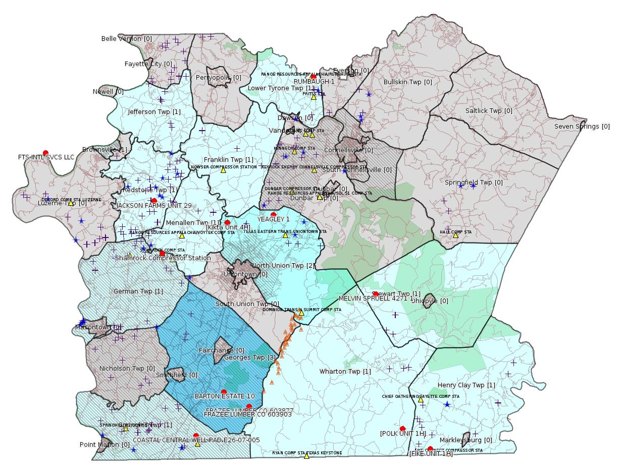
Map
Key
Red dots: items in this permit list with an exact location.
Blue stars: Marcellus Gas Well Water Sources.
Municipality shading: number of "facilities", with each well counting separately
(includes the red dots):
Red dots: items in this permit list with an exact location.
Blue stars: Marcellus Gas Well Water Sources.
Municipality shading: number of "facilities", with each well counting separately
(includes the red dots):
gray: 0
pale turquoise: 1
turquoise: 2
pale blue: 3
middle blue: 4
dark blue: 6
dark purple: 10
purple: 19
(Color coding may differ from one issue to the next.)
(Note if a project spans multiple municipalities -- e.g. a pipeline -- it will show in the count for each municipality.)
The number of facilities also follows the municipality name in brackets.
Municipality counts are based on the way the permit is listed by DEP; DEP has been known to get a municipality wrong.
Locations in brackets identify a precise location used to locate a surrogate for the actual site being permitted (e.g. locating a well pad or pipeline by the known location of a well.) Locations labeled beginning with "~" and ending in "[?]" are approximate and speculative based on inferences using on-line property and lease records. These are marked in the text as "[Approximate, Speculative]
Cross-hatching: Environmental Justice Areas
Yellow triangles: Compressor Stations
Orange triangles: Storage Field Wells (currently Dominion North Summit Storage Field)
Crosses: Unconventional well permits (may not have been drilled)
Green: "Natural areas", e.g. state game lands, state forests
Yellow triangles: Compressor Stations
Orange triangles: Storage Field Wells (currently Dominion North Summit Storage Field)
Crosses: Unconventional well permits (may not have been drilled)
Green: "Natural areas", e.g. state game lands, state forests
More Maps
 |
Source: Pennsylvania Bulletin
26-00588A: Laurel Mountain Midstream Operating, LLC (1550 Coraopolis Heights Road, Suite 140, Moon Township, PA 15108) Extension effective February 28, 2017, to extend the period of temporary operation of the new dehydrator and emergency generator authorized under plan approval PA-26-00588A at Shamrock Compressor Station located in German Township, Fayette County. One Solar Titan 130 turbine rated at 19,553 HP and originally authorized to be installed at this facility under PA-26-00588A is no longer authorized as the 18-month period to commence construction specified under 25 Pa. Code § 127.13(b) has passed.
26-00588: Laurel Mountain Midstream Operating, LLC (1550 Coraopolis Heights Road, Suite 140, Moon Township, PA 15108) Extension effective February 28, 2017, to extend the period of temporary operation of the three Caterpillar G3516B natural gas-fired compressor engines rated at 1,380 bhp each and controlled by oxidation catalysts, and a Solar Mars 100 gas-fired turbine rated at 15,525 bhp authorized under plan approval PA-26-00588 at Shamrock Compressor Station located in German Township, Fayette County.
<http://www.pabulletin.com/secure/data/vol47/47-11/474c.html>
Location: 39.918333,-79.825 <http://osm.org/go/ZWpasXGm--?m=>
Municipalities: German Twp [an Environmental Justice Area]
Parcel ID: 15140026
---
26174001. Wampum Hardware Co. (636 Paden Road, New Galilee, PA 16141). Blasting activity permit for the Earth Movers Philips Mine Fire, located in Uniontown Township, Fayette County with an expiration date of December 31, 2018. Blasting permit issued: March 6, 2017.
<http://www.pabulletin.com/secure/data/vol47/47-11/474c.html>
Location [of Kikta Unit 4H, a well on the adjoining property]: 39.946967,-79.743442 <http://osm.org/go/ZWpxig3~--?m=>
Municipalities: North Union Twp, Uniontown [???: Uniontown here is probably incorrect -jr]
Presumed Parcel Id: 25060026
Well Details Report Record (Kikta 4H):
<https://www.paoilandgasreporting.state.pa.us/publicreports/Modules/WellDetails/WellDetails.aspx?PermitNumber=051-24471>
[See Notes from the 11/15/15 issue for more information about the association of the Phillips Mine Fire and the Kikta well pad.]
-------------------------
Source: eNOTICE (+ PA Oil and Gas Mapping, Well Pad Report) Please see the Disclaimer below regarding Parcel Id data.
Authorization ID: 1169862
Permit number: 26174001
Site: EARTH MOVERS PHILIPS MINE FIRE
Client: WAMPUM HDWR CO
Authorization type: Blasting Activity Permit
Application type: New
Authorization is for: SITE
Date received: 02/15/2017
Status: Issued on 3/6/2017
<http://www.ahs.dep.pa.gov/eFACTSWeb/searchResults_singleAuth.aspx?AuthID=1169862>
[For location information see above.]
Authorization ID: 1171948
Permit number: PAR316106
Site: FTS INTL SVCS LLC BROWNSVILLE FAC
Client: FTS INTL SVC LLC
Authorization type: PAG-03 Discharge of Stormwater Assoc w Industrial Activities
Application type: Rescission
Authorization is for: FACILITY
Date received: 03/03/2017
Status: Ceased Discharging on 3/3/2017
<http://www.ahs.dep.pa.gov/eFACTSWeb/searchResults_singleAuth.aspx?AuthID=1171948>
Location [??]: 40.016013,-79.968410 <http://osm.org/go/ZWpcSR4Y--?m=>
Municipalities: Brownsville Boro [probably incorrect -jr]
[See Notes.]
Authorization ID: 1172242
Permit number: ESG17-051-0001
Site: LPR MIDSTREAM PARTNERS LLC POLK PIPELINE ESCGP ESG17-051-0001
Client: LPR MIDSTREAM PARTNERS LLC
Authorization type: Erosion and Sediment Control GP-2
Application type: New
Authorization is for: SITE
Date received: 03/06/2017
Status: Pending
<http://www.ahs.dep.pa.gov/eFACTSWeb/searchResults_singleAuth.aspx?AuthID=1172242>
Municipalities: Henry Clay Twp, Wharton Twp
Location [of POLK UNIT 1H]: 39.746494,-79.529567 <http://osm.org/go/ZWpqHRIj--?m=>
Presumed Parcel Id: 4233000106
Location [of FIKE UNIT 1H]: 39.727028 -79.495752 <http://osm.org/go/ZWpqgA7n--?m=>
Parcel Id: 16190003
Municipalities: Henry Clay Twp, Wharton Twp
[See Notes.]
Authorization ID: 1172759
Permit number: ESX11-051-0016
Site: CONSTATINE TO LYNN PIPELINE ESCGP ESX11-051-0016
Client: LAUREL MTN MIDSTREAM OPR LLC
Authorization type: Expedited E&S Stormwater General Permit 1
Application type: Amendment
Authorization is for: SITE
Date received: 03/03/2017
Status: Pending
<http://www.ahs.dep.pa.gov/eFACTSWeb/searchResults_singleAuth.aspx?AuthID=1172759>
Municipalities: Franklin Twp, Jefferson Twp, Menallen Twp
[Conventional Well:]
Authorization ID: 1169001
Permit number: 051-00127
Site: FRAZEE LUMBER 603877 WELL
Client: EQT PRODUCTION CO
Authorization type: Well Plugging Notice Intent to Plug Single Well
Application type: New
Authorization is for: FACILITY
Date received: 02/08/2017
Status: Pending
Sub-Facility ID Sub-Facility Name Description
56087 FRAZEE LUMBER CO 603877 Well
<http://www.ahs.dep.pa.gov/eFACTSWeb/searchResults_singleAuth.aspx?AuthID=1169001>
Location: 39.770006,-79.719653 <http://osm.org/go/ZWpg~3uJ--?m=>
Municipalities: Georges Twp [an Environmental Justice Area]
Presumed Parcel Id: 14370013
Well Details Report Record:
<https://www.paoilandgasreporting.state.pa.us/publicreports/Modules/WellDetails/WellDetails.aspx?PermitNumber=051-00127>
[Conventional Well:]
Authorization ID: 1169036
Permit number: 051-20737
Site: BARTON ESTATE 10 WELL
Client: EQT PRODUCTION CO
Authorization type: Well Plugging Notice Intent to Plug Single Well
Application type: New
Authorization is for: FACILITY
Date received: 02/02/2017
Status: Pending
Sub-Facility ID Sub-Facility Name Description
56914 BARTON ESTATE 10 Well
<http://www.ahs.dep.pa.gov/eFACTSWeb/searchResults_singleAuth.aspx?AuthID=1169036>
Location: 39.784419,-79.750471 <http://osm.org/go/ZWphk6Oo--?m=>
Municipalities: Georges Twp [an Environmental Justice Area]
Presumed Parcel Id: 14370013
Well Details Report Record:
<https://www.paoilandgasreporting.state.pa.us/publicreports/Modules/WellDetails/WellDetails.aspx?PermitNumber=051-20737>
[Conventional Well:]
Authorization ID: 1169044
Permit number: 051-00126
Site: FRAZEE LUMBER 603903 WELL
Client: EQT PRODUCTION CO
Authorization type: Well Plugging Notice Intent to Plug Single Well
Application type: New
Authorization is for: FACILITY
Date received: 02/08/2017
Status: Pending
Sub-Facility ID Sub-Facility Name Description
56086 FRAZEE LUMBER CO 603903 Well
<http://www.ahs.dep.pa.gov/eFACTSWeb/searchResults_singleAuth.aspx?AuthID=1169044>
Location: 39.766986,-79.722321 <http://osm.org/go/ZWpg~O_9--?m=>
Municipalities: Georges Twp [an Environmental Justice Area]
Presumed Parcel Id: 14370013
Well Details Report Record:
<https://www.paoilandgasreporting.state.pa.us/publicreports/Modules/WellDetails/WellDetails.aspx?PermitNumber=051-00126>
[Conventional Well:]
Authorization ID: 1159660
Permit number: 051-21095
Site: RUMBAUGH 1 OG WELL
Client: RANGE RESOURCES APPALACHIA LLC
Authorization type: Well Plugging Notice Intent to Plug Single Well
Application type: New
Authorization is for: FACILITY
Date received: 08/08/2016
Status: Pending
Sub-Facility ID Sub-Facility Name Description
435555 RUMBAUGH 1 Well
<http://www.ahs.dep.pa.gov/eFACTSWeb/searchResults_singleAuth.aspx?AuthID=1159660>
Location: 40.085135,-79.633338 <http://osm.org/go/ZWsirkpT--?m=>
Municipality: Lower Tyrone Twp
Presumed Parcel Id: 18050023
Well Details Report Record:
<https://www.paoilandgasreporting.state.pa.us/publicreports/Modules/WellDetails/WellDetails.aspx?PermitNumber=051-21095>
[Conventional Well:]
Authorization ID: 1110133
Permit number: 051-20022
Site: MELVIN SPRUELL 1 OG WELL
Client: XTO ENERGY INC
Authorization type: Well Plugging Notice Intent to Plug Single Well
Application type: New
Authorization is for: FACILITY
Date received: 03/02/2016
Status: Pending
Sub-Facility ID Sub-Facility Name Description
56229 MELVIN SPRUELL 4271 1 Well
<http://www.ahs.dep.pa.gov/eFACTSWeb/searchResults_singleAuth.aspx?AuthID=1110133>
Location: 39.876056,-79.560111 <http://osm.org/go/ZWpttJR5--?m=>
Presumed Parcel Id: 37100001
Municipalities: Stewart Twp
Well Details Report Record:
<https://www.paoilandgasreporting.state.pa.us/publicreports/Modules/WellDetails/WellDetails.aspx?PermitNumber=051-20022>
Authorization ID: 1161323
Permit number: E26-07-005
Site: COASTAL CENTRAL WELL PAD E26-07-005
Client: BURNETT OIL CO INC
Authorization type: Water Obstruction & Encroachment Pmt
Application type: New
Authorization is for: FACILITY
Date received: 10/14/2016
Status: Pending
Sub-Facility ID Sub-Facility Name Description
1222427 COASTAL CENTRAL WELL PAD E26-07-005 Pipeline or Conduit
Permit Review Notes:
Date Review Note
2/21/2017 Applicant has been issued a deficiency letter. If applicable, this application no longer qualifies for the Permit Decision Guarantee.
<http://www.ahs.dep.pa.gov/eFACTSWeb/searchResults_singleAuth.aspx?AuthID=1161323>
Location: 39.743049,-79.786279 <http://osm.org/go/ZWpgHiKC--?m=>
Municipalities: Springhill Twp
Presumed Parcel Id: 36210048
-------------------------
Source: DEP Oil and Gas Compliance Report
OPERATOR: ATLAS RESOURCES LLC
INSPECTION_ID: 2567466
INSPECTION_DATE: 03/03/2017
INSPECTION_TYPE: Routine/Complete Inspection
API_PERMIT: 051-24227
FARM_NAME: JACKSON FARMS UNIT 29
UNCONVENTIONAL: Y
SITE_ID: 720646
SITE_NAME: JACKSON FARMS UNIT 29 OG WELL
FACILITY_TYPE: Oil & Gas Location
INSPECTION_CATEGORY: Primary Facility
REGION: EP DOGO SWDO Dstr Off
COUNTY: Fayette
MUNICIPALITY: Redstone Twp
INSPECTOR: NAJEWICZ, JUSTIN
INSPECTION_RESULT_DESCRIPTION: No Violations Noted
INSPECTION_COMMENT: The Act 9 sign was in place and all required documents were present at the site. The site was well vegetated and there were no signs of erosion observed. The well heads appeared to be in good condition, but is recommended the brine tanks be inspected for corrosion. There were no violations observed at the time of inspection.
Location: 39.968689,-79.834181 <http://osm.org/go/ZWpbyIwX--?m=>
Presumed Parcel Id: 30310028
Well Details Report Record:
<https://www.paoilandgasreporting.state.pa.us/publicreports/Modules/WellDetails/WellDetails.aspx?PermitNumber=051-24227>
[There is a similar record for 051-24228, JACKSON FARMS UNIT 36H.]
---
OPERATOR: ATLAS RESOURCES LLC
INSPECTION_ID: 2568295
INSPECTION_DATE: 03/07/2017
INSPECTION_TYPE: Routine/Complete Inspection
API_PERMIT: 051-24200
FARM_NAME: YEAGLEY 1
UNCONVENTIONAL: Y
SITE_ID: 719003
SITE_NAME: YEAGLEY 1 OG WELL
FACILITY_TYPE: Oil & Gas Location
INSPECTION_CATEGORY: Primary Facility
REGION: EP DOGO SWDO Dstr Off
COUNTY: Fayette
MUNICIPALITY: North Union Twp
INSPECTOR: NAJEWICZ, JUSTIN
INSPECTION_RESULT_DESCRIPTION: No Violations Noted
INSPECTION_COMMENT: The Act 9 sign was in place and all required documents were present. The site was well vegetated and no signs of erosion were observed. The wellhead appeared to be in good condition. The brine tanks exhibited signs of corrosion (see photographs). It is recommended the tanks be inspected for integrity. There were no violations observed at the time of inspection.
Location: 39.953759,-79.685815 <http://osm.org/go/ZWpzJs1K--?m=>
Presumed Parcel Id: 25020029
Well Details Report Record:
<https://www.paoilandgasreporting.state.pa.us/publicreports/Modules/WellDetails/WellDetails.aspx?PermitNumber=051-24200>
-------------------------
Source: Reuters Commodities: Energy
Natural Gas
| Commodity | Exchange | Currency | Expire | Last Trade | Trade Time | Change | Open | Day's High | Day's Low |
|---|---|---|---|---|---|---|---|---|---|
| NATURAL
GAS CON1 Mar17 |
NYM | USD | 03/29 | 3.07 | 03/19 22:41 | +0.03 | 3.08 | 3.08 | 3.07 |
<http://www.reuters.com/finance/commodities/energy>
-------------------------
Notes:
FTS INTL SVCS LLC appears to be the parent company of what has been known locally as Frac Tech. There is serious uncertainty about the location. The address shows as 810 LOW HILL RD, BROWNSVILLE, PA 15417. Apparently Low Hill Road is on the north side of the Mon River, which means this location is in Washington County, not Fayette County, and Brownsville Boro has to be incorrect as the municipality. Bing and Mapquest map this about where I'm showing it, but Google shows it closer to Brownsville but still on the opposite side of the river from Fayette County.
This site received a violation "Industrial waste was discharged without a permit", Inspection Id, 1982131, 06/09/2011, and was assessed a penalty of $7500. See:
<http://www.ahs.dep.pa.gov/eFACTSWeb/searchResults_singleViol.aspx?InspectionID=1982131>
FTS International describes itself as follows: "FTS International is one of the largest well completion companies in North America and has a joint venture in China with Sinopec Group. Exploration and production companies rely on FTSI’s deep expertise and customized hydraulic fracturing solutions to enhance their recovery rates from oil and gas wells, primarily in unconventional plays."
---
The wells at Polk and Fike all seem to be inactive. Locations for POLK UNIT 1H and FIKE UNIT 1H are exact; it's speculation that these correctly locate the ends of the pipeline applied for as LPR MIDSTREAM PARTNERS LLC POLK PIPELINE ESCGP ESG17-051-0001 above.
------------------------
DEP defines an environmental justice area as "any census tract where 20 percent or more individuals live in poverty, and/or 30 percent or more of the population is minority". (See:
<http://www.dep.pa.gov/PublicParticipation/OfficeofEnvironmentalJustice/Pages/default.aspx>). There are supposed to be enhanced public participation requirements for permits in environmental justice areas, but news of this actually ever happening is scarce. In Fayette County, the entirety of Springhill, Nicholson, German, and Georges Townships are environmental justice areas, as well as a large part of Dunbar Township. DEP's policy document on public participation guidelines for environmental justice areas is located here:
<http://www.elibrary.dep.state.pa.us/dsweb/Get/Version-48671/012-0501-002.pdf>
eNOTICE records are likely to list the same permit multiple times, as that permit moves through the DEP process.
Oil & Gas Wells designated with a site a number and the letter H typically designate horizontal wells.
-------------------------
Resources:
Pennsylvania Bulletin: <http://www.pabulletin.com/>
eNOTICE: <http://www.ahs2.dep.state.pa.
DEP Well Details Report: <https://www.paoilandgasreport
Well Details may not show any
information for new permits and will not show permits which have
not yet been issued. Lookup for Well Details is by permit number.
DEP Permits Issued Detail Report:
<http://www.depreportingservic
DEP SPUD (drilling started) Report:
<http://www.depreportingservices.state.pa.us/ReportServer/Pages/ReportViewer.aspx?/Oil_Gas/Spud_External_Data>
DEP Oil and Gas Compliance Report:
<http://www.depreportingservices.state.pa.us/ReportServer/Pages/ReportViewer.aspx?/Oil_Gas/OG_Compliance>
DEP PA Oil & Gas Mapping:
<http://www.depgis.state.pa.us/PaOilAndGasMapping>
DEP Oil and Gas Electronic Notifications
<http://www.depreportingservices.state.pa.us/ReportServer?/Oil_Gas/OG_Notifications>
DEP Oil and Gas Well Pad Report
<http://www.depreportingservices.state.pa.us/ReportServer?/Oil_Gas/Well_Pads>
Fayette County Assessment Office Search For Tax Records:
<http://property.co.fayette.pa.us/search.aspx>
Pennsylvania Spatial Data Access:
<http://www.pasda.psu.edu/default.asp>
DEP Spatial Data Repository:
<ftp://www.pasda.psu.edu/pub/pasda/dep/>
National Response Center:
<http://www.nrc.uscg.mil/>
EPA-Echo: <http://www.epa-echo.gov/echo/
FERC citizen involvement: <http://www.ferc.gov/for-citiz
To receive E-mail notification of
all documents filed in a FERC docket, see:
<http://www.ferc.gov/docs-filing/esubscription.asp >
<http://www.ferc.gov/docs-fili
Follow the directions and enter the docket number to subscribe to.
Township Supervisors receive information regarding Erosion & Sedimentation permits, and these records may be reviewable at township municipal offices.
DEP permits are reviewable through the File Review process, for application to do file review see: <http://www.portal.state.pa.us/portal/server.pt/community/southwest_regional_office/13775/file_review/593164>
Environmental Hearing Board: <http://ehb.courtapps.com/publ
PA DEP Environmental Policy Comment System:
<http://www.ahs.dep.pa.gov/eComment/>
Federal Register Environment: <https://www.federalregister.g
Browsing of recent comment
opportunities for federal agencies, e.g. EPA. Click "sign up" to
subscribe to daily E-mails of new document listings.
SkyTruth Fayette County Drilling Alerts: <http://frack.skytruth.org/pen
U.S. Army Corps of Engineers, Pittsburgh District, Public Notices:
<http://www.lrp.usace.army.mil/Missions/Regulatory/Public-Notices/>
EPA Pennsylvania Public Notices: <http://www2.epa.gov/aboutepa/epa-pennsylvania#notice>
Marcellus Shale waste disposal
injection wells in Pennsylvania are regulated directly by EPA, not
DEP. Notice of any new permit applications will appear at the
above web address. I'm not aware of any subscription service
to be notified of such applications. I'm not aware of any
Marcellus Shale waste disposal injection wells in Fayette County
(yet ...) but we need to monitor this page for future
applications.
Energy Assurance Daily: <http://www.oe.netl.doe.gov/ead.aspx>
Daily newsletter from the US
Department of Energy about events relating to energy. The Natural
Gas section has information about pipelines.
-------------------------
Disclaimers:
This compilation from the above sources was done by hand using copy and paste and may omit relevant permits.
Parcel data is provided via the tax records search web page offered by the Fayette County Assessment Office (http://property.co.fayette.pa.us/). Presumed Parcel Id links are subject to availability provided by that agency and associated web sites. Presumed Parcel Ids are determined as the mapped parcel containing a given latitude and longitude, are a best effort determination which is subject to error, and are not official. In cases where a facility is leased and there is a separate parcel id for the lease, if this parcel id is not separately mapped, the parcel id shown will be the id for the enclosing parcel. Parcel owners may be surface owners only and may or may not have any relationship to oil & gas facilities.
Does not currently include water supply permits. Does not include landfill permits even though many such are for Marcellus Shale waste. (It is not possible at this time to distinguish which landfill permits are for Marcellus Shale waste and which are not without doing File Review for each permit.)
Erosion & Sedimentation permit records do not currently include latitude and longitude. Where I am publishing latitude and longitude with E&S permits it is by inferring an associated well permit and using published latitude and longitude for the well. It is possible I may be inferring the wrong well site.
Municipalities are shown from eFACTS records on the DEP web site. The DEP has been known to list a municipality incorrectly.