The Harmed Success Stories Concepts How To What Is Commentary
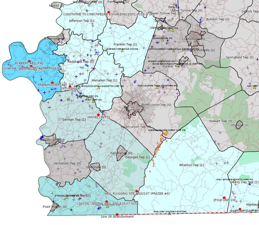
Fayette County Marcellus Shale Permits 4/17/17 - 4/30/17
Click the map to enlarge

Map
Key
Red dots: items in this permit list with an exact location.
Blue stars: Marcellus Gas Well Water Sources.
Municipality shading: number of "facilities", with each well counting separately
(includes the red dots):
Red dots: items in this permit list with an exact location.
Blue stars: Marcellus Gas Well Water Sources.
Municipality shading: number of "facilities", with each well counting separately
(includes the red dots):
gray: 0
pale turquoise: 1
turquoise: 2
pale blue: 3
middle blue: 4
dark blue: 6
dark purple: 10
purple: 19
(Color coding may differ from one issue to the next.)
(Note if a project spans multiple municipalities -- e.g. a pipeline -- it will show in the count for each municipality.)
The number of facilities also follows the municipality name in brackets.
Municipality counts are based on the way the permit is listed by DEP; DEP has been known to get a municipality wrong.
Locations in brackets identify a precise location used to locate a surrogate for the actual site being permitted (e.g. locating a well pad or pipeline by the known location of a well.) Locations labeled beginning with "~" and ending in "[?]" are approximate and speculative based on inferences using on-line property and lease records. These are marked in the text as "[Approximate, Speculative]
Cross-hatching: Environmental Justice Areas
Yellow triangles: Compressor Stations
Orange triangles: Storage Field Wells (currently Dominion North Summit Storage Field)
Crosses: Unconventional well permits (may not have been drilled)
Green: "Natural areas", e.g. state game lands, state forests
Yellow triangles: Compressor Stations
Orange triangles: Storage Field Wells (currently Dominion North Summit Storage Field)
Crosses: Unconventional well permits (may not have been drilled)
Green: "Natural areas", e.g. state game lands, state forests
More Maps
 |
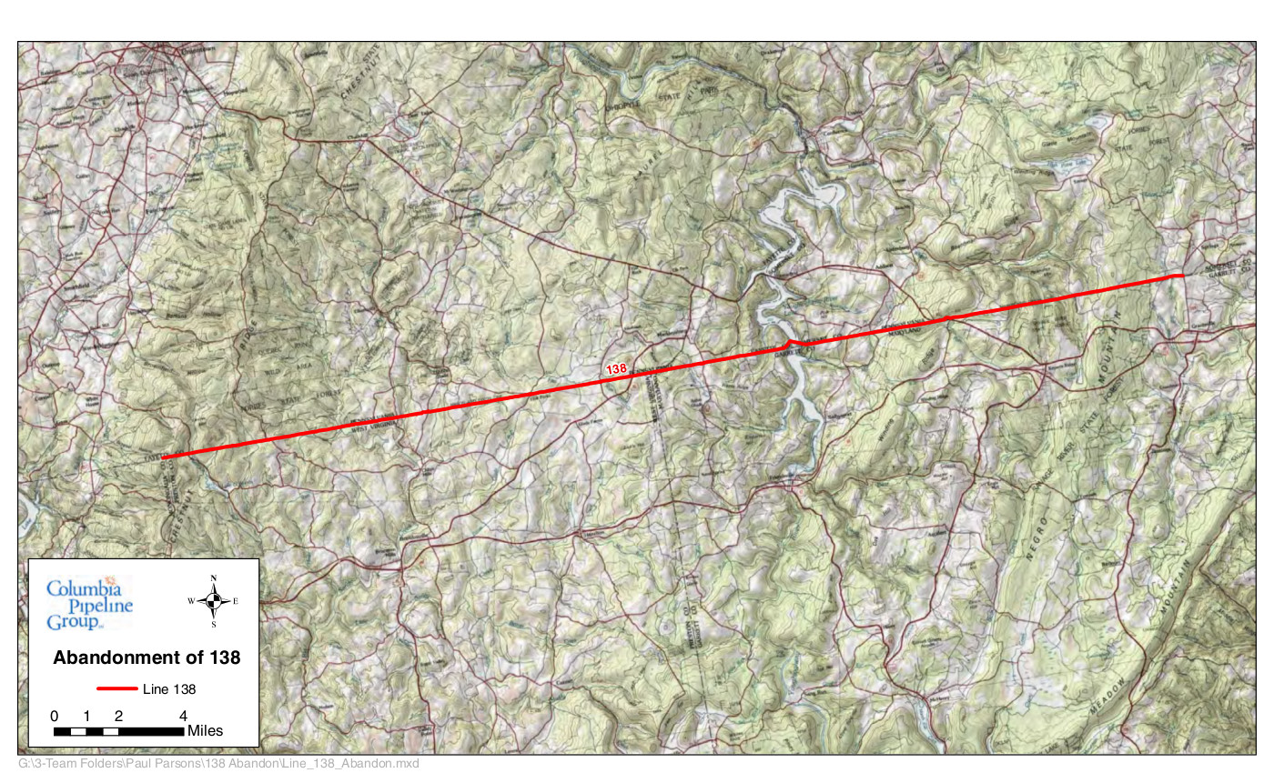 |
Source: Pennsylvania Bulletin
Final State Water Quality Certification Required by Section 401 of the Clean Water Act for the Line 138 Service Abandonment and Lateral Construction Project
Southwest Region: Waterways & Wetlands Program, 400 Waterfront Drive, Pittsburgh, PA 15222, Rita A. Coleman, 412-442-4000.
WQ05-011, Columbia Gas Transmission, LLC (Applicant), 1700 MacCorkle Avenue, S.E. Charleston, WV 25314. Line 138 Service Abandonment and Lateral Construction Project (Project), in Springhill, Henry Clay and Wharton Townships, Fayette County and Addison and Elk Lick Townships, Somerset County, ACOE Pittsburgh District. The proposed project starts approximately 2.25 miles southeast of the intersection of State Route 857 and Gans Road in Springhill Township, Fayette County (Lake Lynn, PA, WV Quadrangle N: 39°, 43`, 16"; W: -79°, 45`, 49") and ends approximately 0.7 mile southwest of the intersection of State Route 669 and Ash Hill Road in Elk Lick Township, Somerset County (Grantsville, MD, PA Quadrangle N: 39°, 43`, 22"; W: -79°, 10`, 18").
On May 20, 2015, Applicant filed an application with the Federal Energy Regulatory Commission (FERC) under Section 7 of the Natural Gas Act (15 U.S.C.A. § 717f) seeking a certificate of public convenience and necessity to construct and operate its Project (FERC Docket No. CP15-495-000). The FERC Environmental Assessment for the Project, which was issued on 9/17/15, may be viewed on FERC's website at www.ferc.gov (search eLibrary; Docket Search; CP15-495-000).
On August 14, 2015, Applicant requested a state water quality certification from the Pennsylvania Department of Environmental Protection (PADEP), as required by Section 401 of the Clean Water Act (33 U.S.C.A. § 1341), to ensure that the construction, operation and maintenance of the Project will protect water quality in Pennsylvania through compliance with State water quality standards and associated State law requirements, which are consistent with the requirements of the Clean Water Act.
The Project includes the operation and maintenance of some segments of the existing, approximately 33-mile, Line 138 natural gas pipeline, consisting of 4-inch, 6-inch, 8-inch and 16-inch pipeline, within an existing 50-foot right-of-way, where service is being abandoned. Columbia proposes to remove approximately 0.18 mile of exposed pipeline, two (2) residential tap consumers, two (2) meter stations, one (1) odorizer, one (1) siphon, five (5) ground valves and eight (8) mainline valves. Columbia plans to grout 28 road crossings to abandon in place.
Columbia also proposes to construct an approximate 0.65-mile, 2-inch lateral extension within the existing 50-foot wide Line 138 right-of-way (ROW) in order to maintain service to the Firm Transportation customer and their operations. The Firm Transportation customer is served from Line 138 through which service will be abandoned, Columbia proposes to maintain gas service to this customer by installing a lateral extension within the Line 138 ROW to connect with Lines 1804 and 10240. The lateral extension project will involve construction activities within the existing 50-foot wide ROW, acquisition of 50 feet of new ROW to connect the lateral to the Line 1804 and 10240 ROW, two (2) new isolation valves on Lines 1804 and 10240, and a contractor/staging yard all located in Somerset County, Pennsylvania. The proposed lateral extension activities are herein referred to as the ''Lateral Construction Project''.
In Pennsylvania, the Project, as proposed, will require impacts to 0.3416 acre of:
Laurel Run (HQ-CWF), Reason Run (WWF), Collier Run (WWF) and Zehner Run (HQ-CWF), and unnamed tributaries of Patterson Run (HQ-CWF), Big Sandy Creek (HQ-CWF), Youghiogheny River (WWF), Chub Run (WWF), Mill Run (WWF), Zehner Run (HQ-CWF), Big Shade Run (CWF), 5.05 acres of floodway, 0.8664 acre of temporary PEM wetland impacts, and 0.0292 acre of PEM and PSS permanent impacts.
PADEP published notice of its proposed state water quality certification in the Pennsylvania Bulletin on (April 2, 2016) (46 Pa. B. 1656) and received no comments from the public.
PADEP certifies to Applicant that the construction, operation and maintenance of the Project will not violate applicable State water quality standards set forth in 25 Pa. Code Chapter 93, provided Applicant complies with the permitting programs, criteria and conditions established pursuant to State law:
1. Discharge Permit—Applicant shall obtain and comply with a PADEP National Pollutant Discharge Elimination System (NPDES) permit for the discharge of water from the hydrostatic testing of the pipeline pursuant to Pennsylvania's Clean Streams Law (35 P.S. §§ 691.1—691.1001), and all applicable implementing regulations (25 Pa. Code Chapter 92a).
2. Erosion and Sediment Control Permit—Applicant shall obtain and comply with PADEP's Chapter 102 Erosion and Sediment Control General Permit for Earth Disturbance Associated with Oil and Gas Exploration, Production, Processing or Treatment issued pursuant to Pennsylvania's Clean Streams Law and Storm Water Management Act (32 P.S. §§ 680.1—680.17), and all applicable implementing regulations (25 Pa. Code Chapter 102).
3. Water Obstruction and Encroachment Permits—Applicant shall obtain and comply with a PADEP Chapter 105 Water Obstruction and Encroachment Permits for the construction, operation and maintenance of all water obstructions and encroachments associated with the project pursuant to Pennsylvania's Clean Streams Law, Dam Safety and Encroachments Act (32 P.S. §§ 673.1—693.27), and Flood Plain Management Act (32 P.S. §§ 679.101—679.601.), and all applicable implementing regulations (25 Pa. Code Chapter 105).
4. Water Quality Monitoring—PADEP retains the right to specify additional studies or monitoring to ensure that the receiving water quality is not adversely impacted by any operational and construction process that may be employed by Applicant.
5. Operation—Applicant shall at all times properly operate and maintain all Project facilities and systems of treatment and control (and related appurtenances) which are installed to achieve compliance with the terms and conditions of this State Water Quality Certification and all required permits, authorizations and approvals. Proper operation and maintenance includes adequate laboratory controls, appropriate quality assurance procedures, and the operation of backup or auxiliary facilities or similar systems installed by Applicant.
6. Inspection—The Project, including all relevant records, are subject to inspection at reasonable hours and intervals by an authorized representative of PADEP to determine compliance with this State Water Quality Certification, including all required State water quality permits and State water quality standards. A copy of this certification shall be available for inspection by the PADEP during such inspections of the Project.
7. Transfer of Projects—If Applicant intends to transfer any legal or equitable interest in the Project which is affected by this State Water Quality Certification, Applicant shall serve a copy of this certification upon the prospective transferee of the legal and equitable interest at least thirty (30) days prior to the contemplated transfer and shall simultaneously inform the PADEP Regional Office of such intent. Notice to PADEP shall include a transfer agreement signed by the existing and new owner containing a specific date for transfer of certification responsibility, coverage, and liability between them.
8. Correspondence—All correspondence with and submittals to PADEP concerning this State Water Quality Certification shall be addressed to the Department of Environmental Protection, Southwest Regional Office, Rita A. Coleman, Program Manager, Waterways and Wetlands Program, 400 Waterfront Drive, Pittsburgh, PA 15222.
9. Reservation of Rights—PADEP may suspend or revoke this State Water Quality Certification if it determines that Applicant has not complied with the terms and conditions of this certification. PADEP may require additional measures to achieve compliance with applicable law, subject to Applicant's applicable procedural and substantive rights.
10. Other Laws—Nothing in this State Water Quality Certification shall be construed to preclude the institution of any legal action or relieve Applicant from any responsibilities, liabilities, or penalties established pursuant to any applicable Federal or State law or regulation.
11. Severability—The provisions of this State Water Quality Certification are severable and should any provision of this certification be declared invalid or unenforceable, the remainder of the certification shall not be affected thereby.
Any person aggrieved by this action may file a petition for review pursuant to Section 19(d) of the Federal Natural Gas Act, 15 U.S.C.A. § 717r(d), with the Office of the Clerk, United States Court of Appeals for the Third Circuit, 21400 U.S. Courthouse, 601 Market Street, Philadelphia, PA 19106-1790 within 30 days of publication of this notice, or within 30 days of receipt of written notice of this action, whichever occurs first. Important legal rights are at stake, so you should show this document to a lawyer at once.
<http://www.pabulletin.com/secure/data/vol47/47-16/674c.html>
For full documents relating to FERC Docket CP15-495, see:
<https://elibrary.ferc.gov/idmws/file_list.asp?document_id=14339903>
Appendix B in this document set specifically applies to Fayette County; see:
<https://elibrary.ferc.gov/idmws/common/OpenNat.asp?fileID=13881887>
Location (west end) <http://osm.org/go/ZWo1fiqN--?m=> [lat/long above]
Location (west end) <http://osm.org/go/ZWqfXkv1--?m=>
---
ESCGP-2 # ESX11-051-0017
Applicant Name Burnett Oil Company Inc
Contact Person Dan Tomley
Address 375 Southpointe Blvd, Suite 430
City, State, Zip Cannonsburg, PA 15317
County Fayette County
Township(s) German Township
Receiving Stream(s) and Classification(s) UNT to North Branch Browns Run (WWF)
Secondary—North Branch Browns Run
<http://www.pabulletin.com/secure/data/vol47/47-17/714c.html>
Site: WHYEL UNIT PREVIOUSLY SUMEY 1H ESCGP-EXPEDITED
Location [of WHYEL UNIT 2]: 39.889344,-79.80168 <http://osm.org/go/ZWplRYcV--?m=>
Municipalities: German Twp [an Environmental Justice Area]
Presumed Parcel Id: 15290036
-------------------------
Source: eNOTICE (+ PA Oil and Gas Mapping, Well Pad Report) Please see the Disclaimer below regarding Parcel Id data.
Authorization ID: 1174700
Permit number: GP05260717-002
Site: CONSTATINE TO LYNN PIPELINE ESCGP ESX11-051-0016 & GP5
Client: LAUREL MTN MIDSTREAM OPR LLC
Authorization type: GP-05 Utility Line Stream Crossings
Application type: New
Authorization is for: FACILITY
Date received: 03/03/2017
Status: Issued on 4/12/2017
Sub-Facility ID Sub-Facility Name Description eMap PA Location
1231646 CONSTANTINE TO LYNN PIPELINE GP05260717-002 Pipeline or Conduit
1230346 CONSTANTINE TO LYNN PIPELINE GP05260717-002 Pipeline or Conduit
<http://www.ahs.dep.pa.gov/eFACTSWeb/searchResults_singleAuth.aspx?AuthID=1174700>
Location: 40.061863,-79.776075 <http://osm.org/go/ZWp1Zgsy--?m=>
Municipalities: Franklin Twp, Jefferson Twp, Menallen Twp
[See Notes.]
Authorization ID: 1171478
Permit number: ESX12-051-0004
Site: POLK TO FIKE PIPELINE ESCGP-EXPEDITED
Client: LPR MIDSTREAM PARTNERS LLC
Authorization type: Expedited E&S Stormwater General Permit 1
Application type: Notification
Authorization is for: SITE
Date received: 02/27/2017
Status: Issued on 4/18/2017
<http://www.ahs.dep.pa.gov/eFACTSWeb/searchResults_singleAuth.aspx?AuthID=1171478>
Municipalities: Henry Clay Twp, Wharton Twp
Location [of POLK UNIT 1H]: 39.746494,-79.529567 <http://osm.org/go/ZWpqHRIj--?m=>
Presumed Parcel Id: 4233000106
Location [of FIKE UNIT 1H]: 39.727028 -79.495752 <http://osm.org/go/ZWpqgA7n--?m=>
Parcel Id: 16190003
[See Notes.]
Authorization ID: 1176035
Permit number: ESX17-051-0002
Site: RUPPERT WELL PAD ESCGP ESX17-051-0002
Client: CHEVRON APPALACHIA LLC
Authorization type: Expedited E&S Stormwater General Permit 1
Application type: New
Authorization is for: SITE
Date received: 03/31/2017
Status: Pending
Permit Review Notes:
Date Review Note
4/24/2017 Applicant has been issued a deficiency letter. If applicable, this application no longer qualifies for the Permit Decision Guarantee.
4/7/2017 Applicant has been issued a deficiency letter. If applicable, this application no longer qualifies for the Permit Decision Guarantee.
<http://www.ahs.dep.pa.gov/eFACTSWeb/searchResults_singleAuth.aspx?AuthID=1176035>
Location: 39.980714,-79.951394 <http://osm.org/go/ZWpZcmDI--?m=>
Municipalities: Luzerne Twp
Act 14 Notification: <http://faymarwatch.org/documents/SKM_554e17041316431.pdf>
Presumed Parcel Id: 19150099
Authorization ID: 1161323
Permit number: E26-07-005
Site: COASTAL CENTRAL WELL PAD E26-07-005
Client: BURNETT OIL CO INC
Authorization type: Water Obstruction & Encroachment Pmt
Application type: New
Authorization is for: FACILITY
Date received: 10/14/2016
Status: Pending
Sub-Facility ID Sub-Facility Name Description
1222427 COASTAL CENTRAL WELL PAD E26-07-005 Pipeline or Conduit
Permit Review Notes:
Date Review Note
2/21/2017 Applicant has been issued a deficiency letter. If applicable, this application no longer qualifies for the Permit Decision Guarantee.
<http://www.ahs.dep.pa.gov/eFACTSWeb/searchResults_singleAuth.aspx?AuthID=1161323>
Location: 39.743049,-79.786279 <http://osm.org/go/ZWpgHiKC--?m=>
Municipalities: Springhill Twp [an Environmental Justice Area]
Presumed Parcel Id: 36210048
Authorization ID: 1174460
Permit number: GP07260717-001
Site: WELL PLUGGING SITE #592197 (FRAZEE #6) GP07260717-001
Client: EQT PRODUCTION CO
Authorization type: GP-07 Minor Road Crossings
Application type: New
Authorization is for: FACILITY
Date received: 02/09/2017
Status: Issued on 4/20/2017
Sub-Facility ID Sub-Facility Name Description
1230220 FRAZEE WELL PLUGGING #6 GP07260717-001 Floodway Activity
<http://www.ahs.dep.pa.gov/eFACTSWeb/searchResults_singleAuth.aspx?AuthID=1174460>
Location: 39.759788,-79.719995 <http://osm.org/go/ZWpg_inI--?m=>
Municipalities: Georges Twp [an Environmental Justice Area]
Presumed Parcel Id: 14410014 [State Game Lands]
Authorization ID: 1179137
Permit number:
Site: FRANKHOUSER UNIT 3H-A OG WELL
Client: CHEVRON APPALACHIA LLC
Authorization type: Residual Waste Processing
Application type: New
Authorization is for: FACILITY
Date received: 04/20/2017
Status: Issued on 4/24/2017
Sub-Facility ID Sub-Facility Name Description
1228008 FRANKHOUSER UNIT ALT RW Residual Waste Processing Locations
<http://www.ahs.dep.pa.gov/eFACTSWeb/searchResults_singleAuth.aspx?AuthID=1179137>
Location: 39.9441,-79.901528 <http://osm.org/go/ZWpY~Set--?m=>
Municipalities: Luzerne Twp
Well Pad Id: 148370
Wells on this pad:
051-24460 FRANKHOUSER UNIT 3H-A
051-24461 FRANKHOUSER UNIT 4H
051-24462 FRANKHOUSER UNIT 5H
051-24463 FRANKHOUSER UNIT 6H
Presumed Parcel Id(s): 19340001, 19320028
[See Notes.]
Authorization ID: 1179647
Permit number: WMGR123SW025
Site: DOGBONE CENTRALIZED WATER FACILITY
Client: CHEVRON APPALACHIA, LLC
Authorization type: RW General Permit Processing Registration
Application type: New
Authorization is for: FACILITY
Date received: 04/25/2017
Status: Pending
<http://www.ahs.dep.pa.gov/eFACTSWeb/searchResults_singleAuth.aspx?AuthID=1179647>
Authorization ID: 1179749
Permit number: WMGR123SW025
Site: DOGBONE CENTRALIZED WATER FACILITY
Client: CHEVRON APPALACHIA, LLC
Authorization type: RW General Permit Processing Registration
Application type: New
Authorization is for: FACILITY
Date received: 04/25/2017
Status: Pending
Sub-Facility ID Sub-Facility Name Description
1232831 DOGBONE CENTRALIZED WATER FACILITY Processing Facility
<http://www.ahs.dep.pa.gov/eFACTSWeb/searchResults_singleAuth.aspx?AuthID=1179749>
Location: 39.972496,-79.946939 <http://osm.org/go/ZWpZaULM--?m=>
Municipalities: Luzerne Twp
Presumed Parcel Id: 19160040
[See Notes.]
-------------------------
Source: DEP Oil and Gas Electronic Notifications
NOTIFICATION_ID: 34208
OGO: 39307
OPERATOR: CHEVRON APPALACHIA LLC
API_PERMIT: 051-24062
SPUD_DATE: 09/30/2008
COUNTY: Fayette
MUNICIPALITY: Redstone
LATITUDE: 39.937693
LONGITUDE: -79.862935
SUBJECT: [NOTIFICATION]: Abandonment or plugging notification 58 Pa. C.S. 3211(f)(2) for well API 37-051-24062-00-00
QUESTION: Date and approximate time action is to occur
ANSWER: Date: 4/27/2017 Time: 8:00AM
SENT_DATE: 4/24/2017 2:30:09 PM
SENT_SUCCESS: Yes
LAST_RESENT_DATE:
RESENT_SUCCESS:
Comments:
Farm Name: SKOVRAN 24
Location: <http://osm.org/go/ZWpacnl2--?m=>
Presumed Parcel Id: 30330064
SPUD Date: 9/30/2008
Conservation Well: Y
Coal: Coal
Most Recent Production Period: Jan - Jun 2013 -- Gas Qty (Mcf): 6157
-------------------------
Source: DEP Oil and Gas Compliance Report
OPERATOR: CHEVRON APPALACHIA LLC
INSPECTION_ID: 2583759
INSPECTION_DATE: 04/18/2017
INSPECTION_TYPE: Routine/Complete Inspection
API_PERMIT: 051-24428
FARM_NAME: POLK UNIT 1H
UNCONVENTIONAL: Yes
SITE_ID: 739411
SITE_NAME: POLK 1H OG WELL
FACILITY_TYPE: Oil & Gas Location
INSPECTION_CATEGORY: Primary Facility
REGION: EP DOGO SWDO Dstr Off
COUNTY: Fayette
MUNICIPALITY: Wharton Twp
INSPECTOR: NAJEWICZ, JUSTIN
INSPECTION_RESULT_DESCRIPTION: MOBILE
INSPECTION_COMMENT: No Violations Noted
VIOLATION_ID: The Act 9 sign was in place and all required documents were present at the site. The site was well vegetated and there were no signs of erosion observed. The wellheads appeared to be in good condition. In the location of the restored tank pad a gravel excavated area was observed. I contacted LPR and was informed that the gravel was buried during Chevron Appalachia LLC's reclamation of the site. LPR was excavating the gravel for use on the site in order to construct a tank pad under an E&S plan, since the site has received an NOT. I recommended that LPR contact DEP engineering staff to confirm that an E&S plan was sufficient and no permitting was required.
Well Pad Id: 149075
Site: POLK 1H OG WELL
Location: 39.746414,-79.529608 <http://osm.org/go/ZWpqHQdO--?m=>
Wells on this pad:
051-24428 POLK UNIT 1H
051-24429 POLK UNIT 2H
051-24431 POLK UNIT 4H
051-24432 POLK UNIT 5H
051-24514 POLK UNIT 3H
-------------------------
Source: Reuters Commodities: Energy
Natural Gas
| Commodity | Exchange | Currency | Expire | Last Trade | Trade Time | Change | Open | Day's High | Day's Low |
|---|---|---|---|---|---|---|---|---|---|
| NATURAL
GAS CON1 May17 |
NYM | USD | 05/26 | 3.23 | 04/30 20:17 | +0.01 | 3.23 | 3.23 | 3.22 |
-------------------------
Notes:
The "point" location mapped regarding authorization 1174700 above in the Constantine to Lynn pipeline project shows the location of a single conduit; the site municipalities apparently reflect the extent of the whole pipeline. (DEP does not typically publish GIS data for pipeline Erosion & Sedimentation permits.)
---
Locations for POLK UNIT 1H and FIKE UNIT 1H are exact; it's speculation that these correctly locate the ends of the pipeline applied for as the POLK TO FIKE PIPELINE above.
---
A previous FRANKHOUSER UNIT ALT RW permit, authorization ID 1170902, was issued on 2/23/2017. Why did they need a second one? We are currently in the dark about these ALT RW permits for older Marcellus well pads.
---
Much of Chevron's more recent drilling activity in Fayette County has focused on Luzerne Twp. It has not been clear why. A wild educated guess would be that something in the results of the Dogbone 3D Seismic Survey has given them an indication that this area is likely to be more productive. The application above for the DOGBONE CENTRALIZED WATER FACILITY is a strong tea leaf in this direction. Note that this application is of type "RW General Permit Processing Registration". That suggests that this facility will include flowback and produced water from surrounding well sites. We don't know whether this facility will be for an impoundment, or enclosed tanks. Centralized flowback / produced water impoundments have had some sorry history in Southwest Pa -- we will have to keep our eyes on this facility.
------------------------
DEP defines an environmental justice area as "any census tract where 20 percent or more individuals live in poverty, and/or 30 percent or more of the population is minority". (See:
<http://www.dep.pa.gov/PublicParticipation/OfficeofEnvironmentalJustice/Pages/default.aspx>). There are supposed to be enhanced public participation requirements for permits in environmental justice areas, but news of this actually ever happening is scarce. In Fayette County, the entirety of Springhill, Nicholson, German, and Georges Townships are environmental justice areas, as well as a large part of Dunbar Township. DEP's policy document on public participation guidelines for environmental justice areas is located here:
<http://www.elibrary.dep.state.pa.us/dsweb/Get/Version-48671/012-0501-002.pdf>
eNOTICE records are likely to list the same permit multiple times, as that permit moves through the DEP process.
Oil & Gas Wells designated with a site a number and the letter H typically designate horizontal wells.
-------------------------
Resources:
Pennsylvania Bulletin: <http://www.pabulletin.com/>
eNOTICE: <http://www.ahs2.dep.state.pa.
DEP Oil and Gas Reports: <http://www.dep.pa.gov/DataandTools/Reports/Oil%20and%20Gas%20Reports/Pages/default.aspx>
DEP Well Details Report: <https://www.paoilandgasreport
Well Details may not show any
information for new permits and will not show permits which have
not yet been issued. Lookup for Well Details is by permit number.
DEP Permits Issued Detail Report:
<http://www.depreportingservic
DEP SPUD (drilling started) Report:
<http://www.depreportingservices.state.pa.us/ReportServer/Pages/ReportViewer.aspx?/Oil_Gas/Spud_External_Data>
DEP Oil and Gas Compliance Report:
<http://www.depreportingservices.state.pa.us/ReportServer/Pages/ReportViewer.aspx?/Oil_Gas/OG_Compliance>
DEP PA Oil & Gas Mapping:
<http://www.depgis.state.pa.us/PaOilAndGasMapping>
DEP Oil and Gas Electronic Notifications
<http://www.depreportingservices.state.pa.us/ReportServer?/Oil_Gas/OG_Notifications>
DEP Oil and Gas Well Pad Report
<http://www.depreportingservices.state.pa.us/ReportServer?/Oil_Gas/Well_Pads>
Fayette County Assessment Office Search For Tax Records:
<http://property.co.fayette.pa.us/search.aspx>
Pennsylvania Spatial Data Access:
<http://www.pasda.psu.edu/default.asp>
DEP Spatial Data Repository:
<ftp://www.pasda.psu.edu/pub/pasda/dep/>
National Response Center:
<http://www.nrc.uscg.mil/>
EPA-Echo: <http://www.epa-echo.gov/echo/
FERC citizen involvement: <http://www.ferc.gov/for-citiz
To receive E-mail notification of
all documents filed in a FERC docket, see:
<http://www.ferc.gov/docs-filing/esubscription.asp >
<http://www.ferc.gov/docs-fili
Follow the directions and enter the docket number to subscribe to.
Township Supervisors receive information regarding Erosion & Sedimentation permits, and these records may be reviewable at township municipal offices.
DEP permits are reviewable through the File Review process, for application to do file review see: <http://www.portal.state.pa.us/portal/server.pt/community/southwest_regional_office/13775/file_review/593164>
Environmental Hearing Board: <http://ehb.courtapps.com/publ
PA DEP Environmental Policy Comment System:
<http://www.ahs.dep.pa.gov/eComment/>
Federal Register Environment: <https://www.federalregister.g
Browsing of recent comment
opportunities for federal agencies, e.g. EPA. Click "sign up" to
subscribe to daily E-mails of new document listings.
SkyTruth Fayette County Drilling Alerts: <http://frack.skytruth.org/pen
U.S. Army Corps of Engineers, Pittsburgh District, Public Notices:
<http://www.lrp.usace.army.mil/Missions/Regulatory/Public-Notices/>
EPA Pennsylvania Public Notices: <http://www2.epa.gov/aboutepa/epa-pennsylvania#notice>
Marcellus Shale waste disposal
injection wells in Pennsylvania are regulated directly by EPA, not
DEP. Notice of any new permit applications will appear at the
above web address. I'm not aware of any subscription service
to be notified of such applications. I'm not aware of any
Marcellus Shale waste disposal injection wells in Fayette County
(yet ...) but we need to monitor this page for future
applications.
Energy Assurance Daily: <http://www.oe.netl.doe.gov/ead.aspx>
Daily newsletter from the US
Department of Energy about events relating to energy. The Natural
Gas section has information about pipelines.
-------------------------
Disclaimers:
This compilation from the above sources was done by hand using copy and paste and may omit relevant permits.
Parcel data is provided via the tax records search web page offered by the Fayette County Assessment Office (http://property.co.fayette.pa.us/). Presumed Parcel Id links are subject to availability provided by that agency and associated web sites. Presumed Parcel Ids are determined as the mapped parcel containing a given latitude and longitude, are a best effort determination which is subject to error, and are not official. In cases where a facility is leased and there is a separate parcel id for the lease, if this parcel id is not separately mapped, the parcel id shown will be the id for the enclosing parcel. Parcel owners may be surface owners only and may or may not have any relationship to oil & gas facilities.
Does not currently include water supply permits. Does not include landfill permits even though many such are for Marcellus Shale waste. (It is not possible at this time to distinguish which landfill permits are for Marcellus Shale waste and which are not without doing File Review for each permit.)
Erosion & Sedimentation permit records do not currently include latitude and longitude. Where I am publishing latitude and longitude with E&S permits it is by inferring an associated well permit and using published latitude and longitude for the well. It is possible I may be inferring the wrong well site.
Municipalities are shown from eFACTS records on the DEP web site. The DEP has been known to list a municipality incorrectly.