The Harmed Success Stories Concepts How To What Is Commentary
Fayette County Marcellus Shale Permits 5/1/17 - 5/14/17
Click the map to enlarge
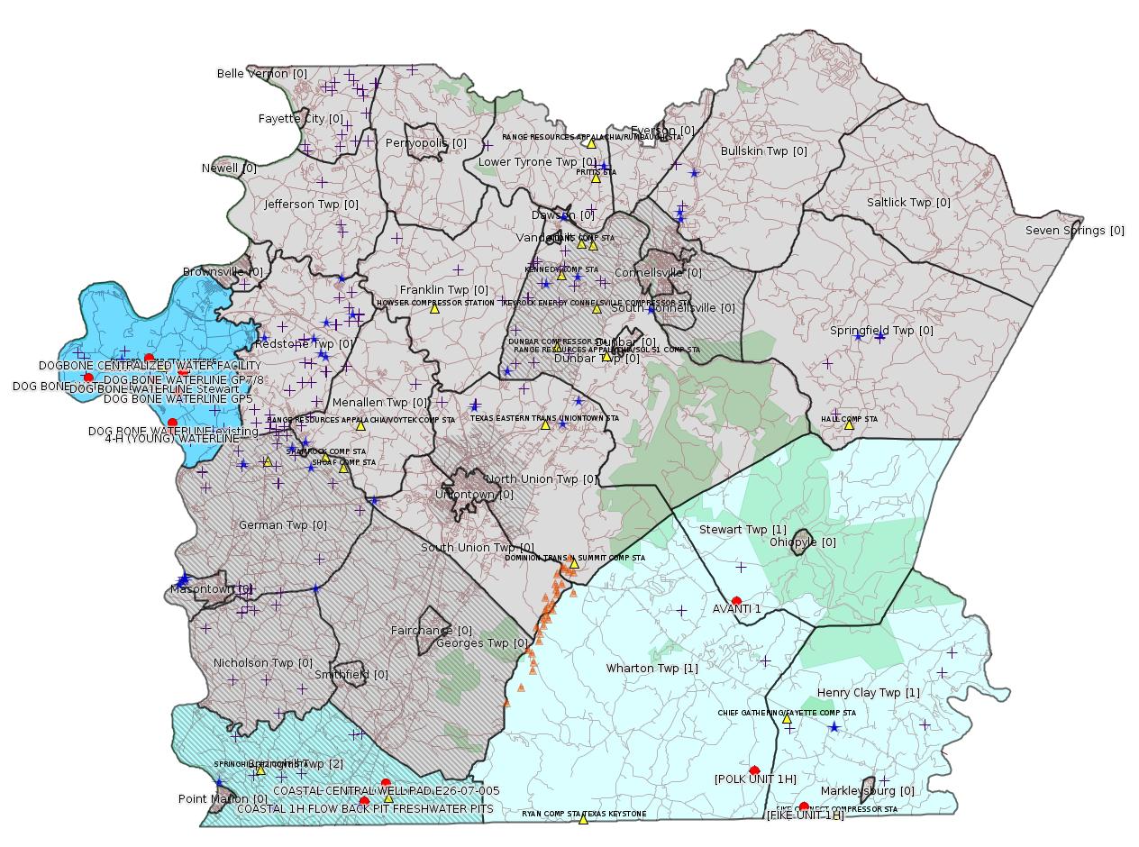
Map
Key
Red dots: items in this permit list with an exact location.
Blue stars: Marcellus Gas Well Water Sources.
Municipality shading: number of "facilities", with each well counting separately
(includes the red dots):
Red dots: items in this permit list with an exact location.
Blue stars: Marcellus Gas Well Water Sources.
Municipality shading: number of "facilities", with each well counting separately
(includes the red dots):
gray: 0
pale turquoise: 1
turquoise: 2
pale blue: 3
middle blue: 4
dark blue: 6
dark purple: 10
purple: 19
(Color coding may differ from one issue to the next.)
(Note if a project spans multiple municipalities -- e.g. a pipeline -- it will show in the count for each municipality.)
The number of facilities also follows the municipality name in brackets.
Municipality counts are based on the way the permit is listed by DEP; DEP has been known to get a municipality wrong.
Locations in brackets identify a precise location used to locate a surrogate for the actual site being permitted (e.g. locating a well pad or pipeline by the known location of a well.) Locations labeled beginning with "~" and ending in "[?]" are approximate and speculative based on inferences using on-line property and lease records. These are marked in the text as "[Approximate, Speculative]
Cross-hatching: Environmental Justice Areas
Yellow triangles: Compressor Stations
Orange triangles: Storage Field Wells (currently Dominion North Summit Storage Field)
Crosses: Unconventional well permits (may not have been drilled)
Green: "Natural areas", e.g. state game lands, state forests
Yellow triangles: Compressor Stations
Orange triangles: Storage Field Wells (currently Dominion North Summit Storage Field)
Crosses: Unconventional well permits (may not have been drilled)
Green: "Natural areas", e.g. state game lands, state forests
More Maps
 |
 |
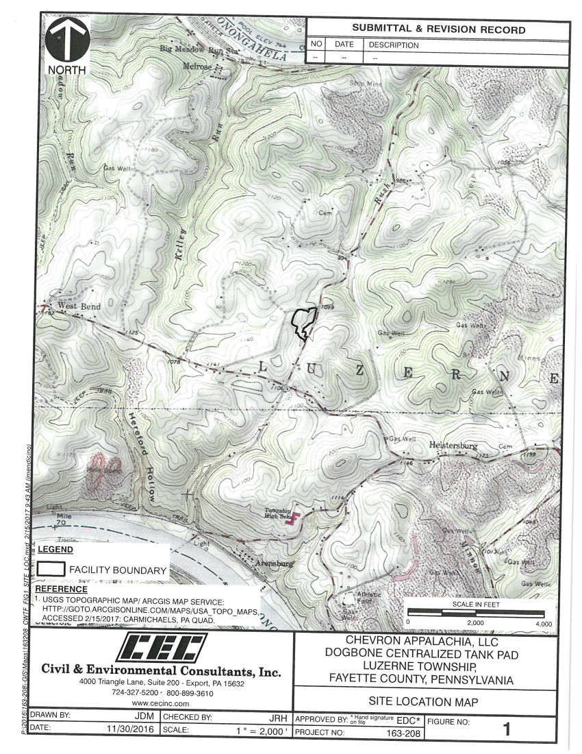 |
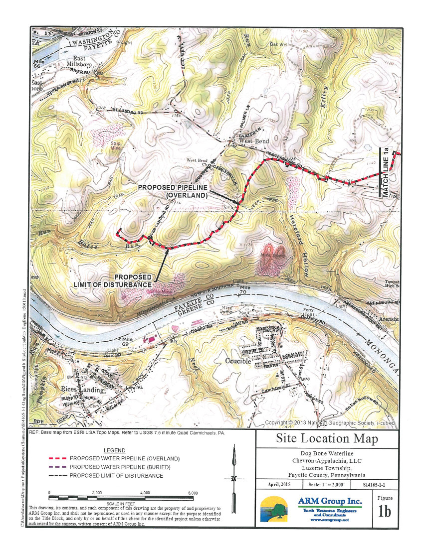
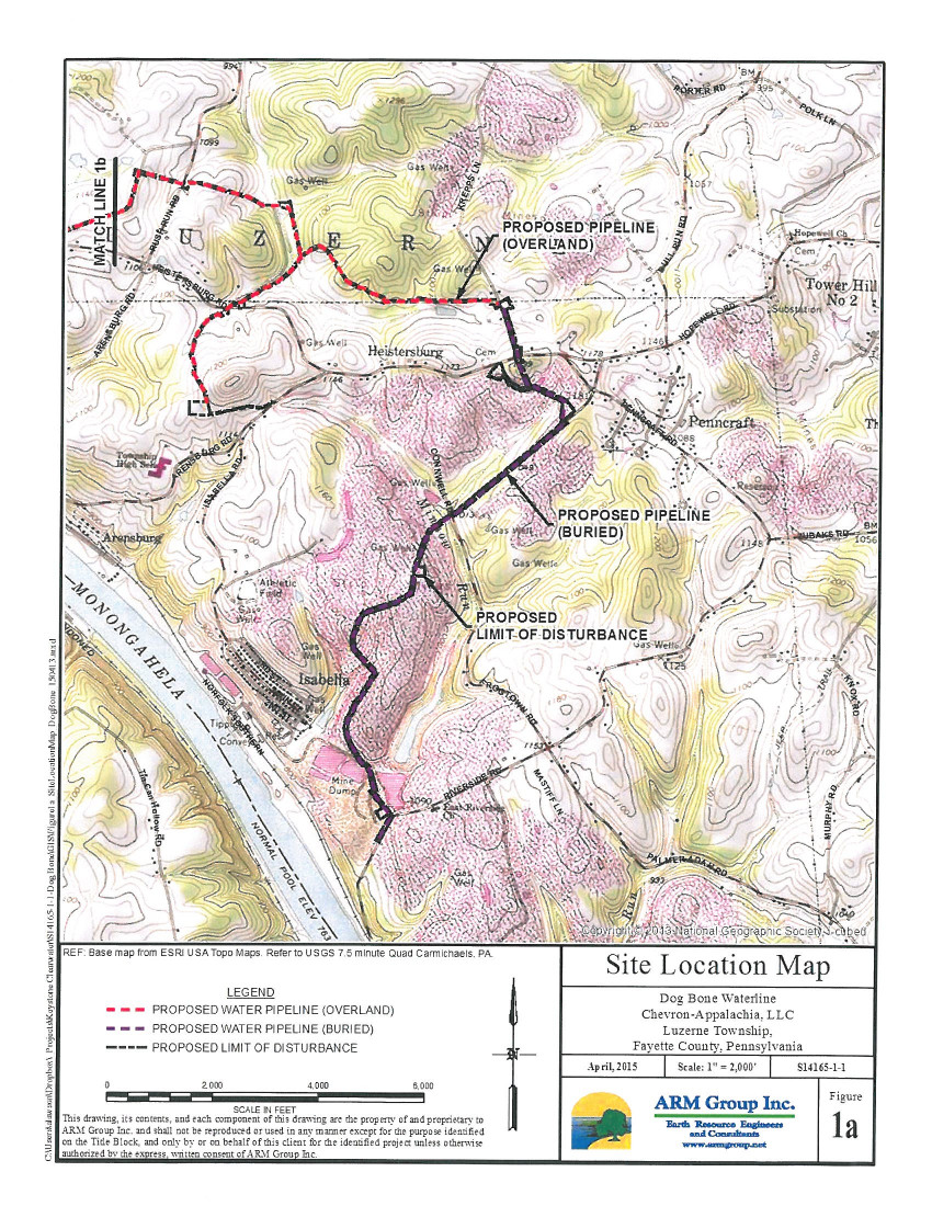
| Focus Luzerne Twp — connect the red dots to an "m" shape to get the approximate path of the Dog Bone Waterline | Dog Bone Centralized Water
Facility topographic map (from the Act 14 NOI) |
|
 |
 |
|
| Dog Bone Waterline West topographic map (from the Act 14 NOI) | Dog Bone Waterline East topographic map (from the Act 14 NOI) |
Source: Pennsylvania Bulletin
NOTICES
Classification of Wild Trout Streams; Proposed Additions and Revisions; July 2017
[47 Pa.B. 2676]
[Saturday, May 6, 2017]
Under 58 Pa. Code § 57.11 (relating to listing of wild trout streams), it is the policy of the Fish and Boat Commission (Commission) to accurately identify and classify stream sections supporting naturally reproducing populations of trout as wild trout streams. The Commission's Fisheries Management Division maintains the list of wild trout streams. The Executive Director, with the approval of the Commission, will from time-to-time publish the list of wild trout streams in the Pennsylvania Bulletin. The listing of a stream section as a wild trout stream is a biological designation that does not determine how it is managed. The Commission relies upon many factors in determining the appropriate management of streams.
At the next Commission meeting on July 10 and 11, 2017, the Commission will consider changes to its list of wild trout streams. Specifically, the Commission will consider the addition of the following streams or portions of streams to the list [Excerpt]:
County of Mouth Stream Name Section Limits Tributary to Mouth Lat./Lon.
Fayette Tates Run Headwaters to Mouth Indian Creek 39.976752 79.509092
The Commission also will consider the following revisions to the section limits of streams on the list:
County of Mouth Stream Name Current Limits Revised Limits Tributary to Mouth Lat./Lon.
Fayette Indian Creek Headwaters to SR 31 Jones Mills Headwaters to Indian Head Road Bridge Youghiogheny River 39.968056 79.513333
<http://www.pabulletin.com/secure/data/vol47/47-18/781.html>
---
ESCGP-2 # ESX10-051-0035
Applicant Name Burnett Oil Company, Inc.
Contact Person Dan Tomley
Address 375 Southpointe Blvd, Suite 430
City, State, Zip Canonsburg, PA 15317
County Fayette County
Township(s) Springhill Township
Receiving Stream(s) and Classification(s) Trib 41094 to
Rubles Run (CWF), Rubles Run (CWF)
<http://www.pabulletin.com/secure/data/vol47/47-18/772c.html>
Site: COASTAL 1H FLOW BACK PIT FRESHWATER PITS ESCGP-EXPEDITED
Location: 39.733294,-79.801028 <http://osm.org/go/ZWpgBJ2N--?m=>
Municipalities: Springhill Twp [an Environmental Justice Area]
Presumed Parcel Id: 36210048
Well Pad Id: 147971
Wells on this pad:
051-24318 COASTAL 1H
051-24382 COASTAL/SMITH UNIT 1H
-------------------------
Source: eNOTICE (+ PA Oil and Gas Mapping, Well Pad Report) Please see the Disclaimer below regarding Parcel Id data.
Authorization ID: 1180168
Permit number: 051-23958
Site: AVANTI 1 OG WELL
Client: CHEVRON APPALACHIA LLC
Authorization type: Well Plugging Notice Intent to Plug Single Well
Application type: New
Authorization is for: FACILITY
Date received: 04/24/2017
Status: Issued on 5/1/2017
Sub-Facility ID Sub-Facility Name Description
965179 AVANTI 1 Well
<http://www.ahs.dep.pa.gov/eFACTSWeb/searchResults_singleAuth.aspx?AuthID=1180168>
Location: 39.837527,-79.54003 <http://osm.org/go/ZWpuQBy2--?m=>
Municipalities: Stewart Twp
Presumed Parcel Id: 37150002
Wells on this pad:
051-23958 AVANTI 1
SPUD Date: 5/16/2008
Well Status: Regulatory Inactive Status
Conservation Well: Y
Well Configuration: Vertical Well
Coal: Coal
WELL PAD ID: 146849
Most Recent Production Period: *Never*
[See Notes.]
[Repeat listing with more information:]
Authorization ID: 1179749
Permit number: WMGR123SW025
Site: DOGBONE CENTRALIZED WATER FACILITY
Client: CHEVRON APPALACHIA, LLC
Authorization type: RW General Permit Processing Registration
Application type: New
Authorization is for: FACILITY
Date received: 04/25/2017
Status: Pending
Sub-Facility ID Sub-Facility Name Description
1232831 DOGBONE CENTRALIZED WATER FACILITY Processing Facility
<http://www.ahs.dep.pa.gov/eFACTSWeb/searchResults_singleAuth.aspx?AuthID=1179749>
Location: 39.972496,-79.946939 <http://osm.org/go/ZWpZaULM--?m=>
Municipalities: Luzerne Twp
Presumed Parcel Id: 19160040
Fayette County Act 14 Notification: <http://faymarwatch.org/documents/SKM_554e17050309530.pdf>
[See Notes.]
Authorization ID: 1181201
Permit number: ESX15-051-0009
Site: DOG BONE WATERLINE ESCGP-2 EXPEDITED
Client: CHEVRON APPALACHIA LLC
Authorization type: Expedited E&S Stormwater General Permit 1
Application type: Notification
Authorization is for: SITE
Date received: 05/08/2017
Status: Pending
<http://www.ahs.dep.pa.gov/eFACTSWeb/searchResults_singleAuth.aspx?AuthID=1181201>
Municipalities: Luzerne Twp
Location [of DOG BONE WATERLINE GP7]: 39.964714,-79.923661 <http://osm.org/go/ZWpZnGdB--?m=>
Locations: Connection to existing water pipeline: 39.937886,-79.931361 <http://osm.org/go/ZWpY0P8E--?m=>;
Stewart well pad 39.960244,-79.943942 <http://osm.org/go/ZWpZOYlA--?m=>;
Baily well pad 39.962475,-79.989728 <http://osm.org/go/ZWpTuXNQ--?m=>
Fayette County Act 14 NOI: <http://faymarwatch.org/documents/SPlanning_Z15050414030.pdf>
[See Notes.]
Authorization ID: 1181205
Permit number: ESX13-051-0006
Site: 4-H (YOUNG) WATERLINE ESCGP-2 EXPEDITED
Client: CHEVRON APPALACHIA LLC
Authorization type: Expedited E&S Stormwater General Permit 1
Application type: Notification
Authorization is for: SITE
Date received: 05/08/2017
Status: Pending
<http://www.ahs.dep.pa.gov/eFACTSWeb/searchResults_singleAuth.aspx?AuthID=1181205>
Location [CROSSING #1]: 39.93365667,-79.93231611 <http://osm.org/go/ZWpYxbQ0-?m=>
Municipalities: Luzerne Twp
Authorization ID: 1172242
Permit number: ESG17-051-0001
Site: LPR MIDSTREAM PARTNERS LLC POLK PIPELINE ESCGP ESG17-051-0001 & GP05 GP08
Client: LPR MIDSTREAM PARTNERS LLC
Authorization type: Erosion and Sediment Control GP-2
Application type: New
Authorization is for: SITE
Date received: 03/06/2017
Status: Pending
<http://www.ahs.dep.pa.gov/eFACTSWeb/searchResults_singleAuth.aspx?AuthID=1172242>
Municipalities: Henry Clay Twp, Wharton Twp
Location [of POLK UNIT 1H]: 39.746494,-79.529567 <http://osm.org/go/ZWpqHRIj--?m=>
Presumed Parcel Id: 4233000106
Location [of FIKE UNIT 1H]: 39.727028 -79.495752 <http://osm.org/go/ZWpqgA7n--?m=>
Parcel Id: 16190003
Municipalities: Henry Clay Twp, Wharton Twp
Authorization ID: 1161323
Permit number: E26-07-005
Site: COASTAL CENTRAL WELL PAD E26-07-005
Client: BURNETT OIL CO INC
Authorization type: Water Obstruction & Encroachment Pmt
Application type: New
Authorization is for: FACILITY
Date received: 10/14/2016
Status: Pending
Sub-Facility ID Sub-Facility Name Description
1222427 COASTAL CENTRAL WELL PAD E26-07-005 Pipeline or Conduit
<http://www.ahs.dep.pa.gov/eFACTSWeb/searchResults_singleAuth.aspx?AuthID=1161323>
Location: 39.743049,-79.786279 <http://osm.org/go/ZWpgHiKC--?m=>
Municipalities: Springhill Twp [an Environmental Justice Area]
Presumed Parcel Id: 36210048
-------------------------
Source: Reuters Commodities: Energy
Natural Gas
| Commodity | Exchange | Currency | Expire | Last Trade | Trade Time | Change | Open | Day's High | Day's Low |
|---|---|---|---|---|---|---|---|---|---|
| NATURAL
GAS CON1 May17 |
NYM | USD | 05/26 | 3.35 | 05/14 20:42 | +0.00 | 3.36 | 3.36 | 3.35 |
-------------------------
Notes:
The Avanti 1 well site was the site of several violations dating to 2008 and 2009. For details see:
<http://www.ahs.dep.pa.gov/eFACTSWeb/searchResults_singleViol.aspx?InspectionID=1712825>
<http://www.ahs.dep.pa.gov/eFACTSWeb/searchResults_singleViol.aspx?InspectionID=1847524>
Fines assessed were 8400 and 7425.
---
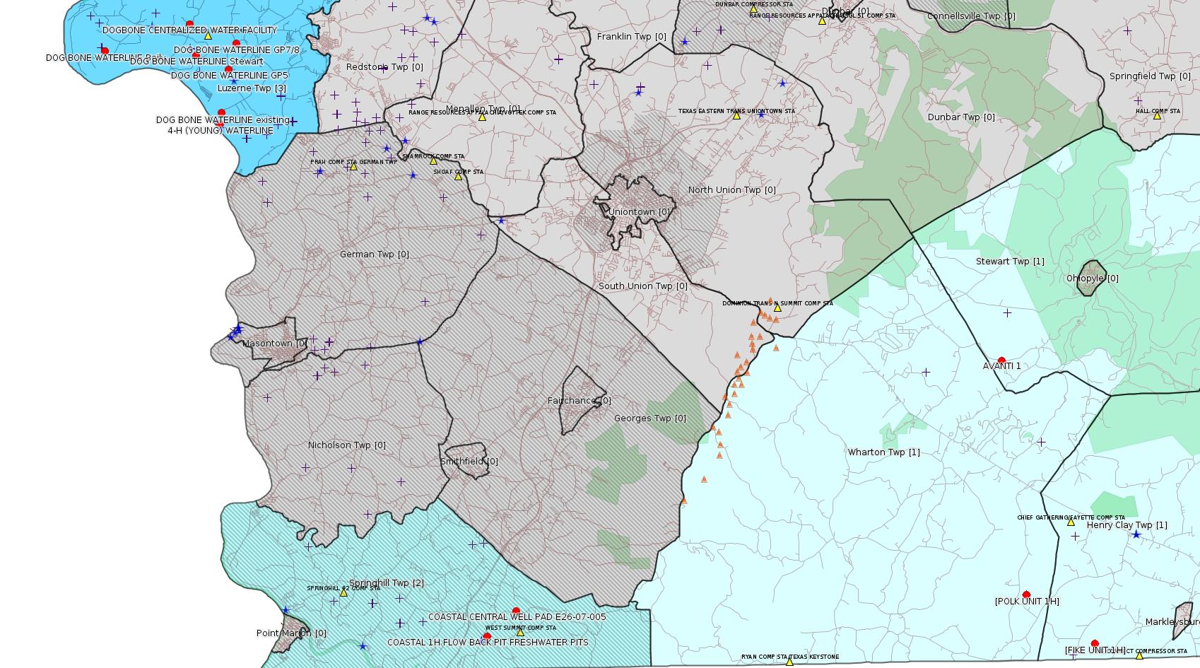
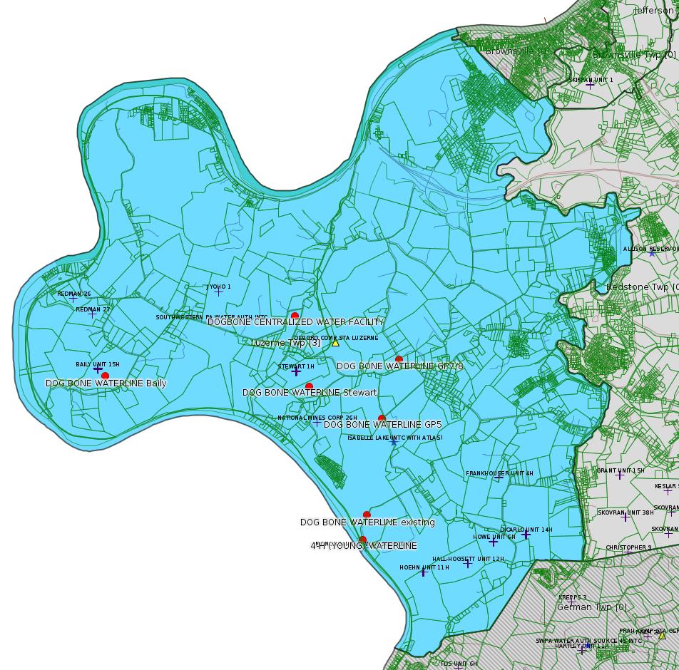
Much of Chevron's more recent drilling activity in Fayette County has focused on Luzerne Twp. It has not been clear why. A wild educated guess would be that something in the results of the Dogbone 3D Seismic Survey has given them an indication that this area is likely to be more productive. The application above for the DOGBONE CENTRALIZED WATER FACILITY is a strong tea leaf in this direction. Note that this application is of type "RW General Permit Processing Registration". The Act 14 Notification indicates that this facility will host 6 1 million-gallon tanks for storing flowback and produced water. This is a strong indication that Chevron intends to drill several new wells in the area in the "near future". (How "near" we really can't tell.)
The Act 14 Notification is thanks to the Fayette County Office of Planning Zoning and Community Development. Fayette County does not post such notifications on its web site, though we certainly wish they would.
---
Locations for the DOG BONE WATERLINE project were taken from the NOI (Notice of Intent) received by the Fayette County Office of Planning Zoning and Community Development under Act 14. The pipeline takes a kind of tilted "m" shape, with the Mon as baseline, the Baily connection at the west end, the Stewart connection in the middle, and the connection to the existing waterline at the east end.
IF THIS PIPELINE LEAKS OR SPILLS it will emit very toxic material directly into the environment with no containment. Produced water, which can be quite radioactive, is precluded from being considered "hazardous waste" by the Haliburton Loophole. Unlike the toxic produced water, which should stay contained in the pipeline as long as it works properly, any radioactivity present in the flowback / produced water can be emitted through the pipeline. The Fayette County Zoning Ordinance at §1000-502 states: “No activity shall emit radioactivity at any point”. As far as anyone knows, this section of the ordinance has never been enforced.
------------------------
DEP defines an environmental justice area as "any census tract where 20 percent or more individuals live in poverty, and/or 30 percent or more of the population is minority". (See:
<http://www.dep.pa.gov/PublicParticipation/OfficeofEnvironmentalJustice/Pages/default.aspx>). There are supposed to be enhanced public participation requirements for permits in environmental justice areas, but news of this actually ever happening is scarce. In Fayette County, the entirety of Springhill, Nicholson, German, and Georges Townships are environmental justice areas, as well as a large part of Dunbar Township. DEP's policy document on public participation guidelines for environmental justice areas is located here:
<http://www.elibrary.dep.state.pa.us/dsweb/Get/Version-48671/012-0501-002.pdf>
eNOTICE records are likely to list the same permit multiple times, as that permit moves through the DEP process.
Oil & Gas Wells designated with a site a number and the letter H typically designate horizontal wells.
-------------------------
Resources:
Pennsylvania Bulletin: <http://www.pabulletin.com/>
eNOTICE: <http://www.ahs2.dep.state.pa.
DEP Oil and Gas Reports: <http://www.dep.pa.gov/DataandTools/Reports/Oil%20and%20Gas%20Reports/Pages/default.aspx>
DEP Well Details Report: <https://www.paoilandgasreport
Well Details may not show any
information for new permits and will not show permits which have
not yet been issued. Lookup for Well Details is by permit number.
DEP Permits Issued Detail Report:
<http://www.depreportingservic
DEP SPUD (drilling started) Report:
<http://www.depreportingservices.state.pa.us/ReportServer/Pages/ReportViewer.aspx?/Oil_Gas/Spud_External_Data>
DEP Oil and Gas Compliance Report:
<http://www.depreportingservices.state.pa.us/ReportServer/Pages/ReportViewer.aspx?/Oil_Gas/OG_Compliance>
DEP PA Oil & Gas Mapping:
<http://www.depgis.state.pa.us/PaOilAndGasMapping>
DEP Oil and Gas Electronic Notifications
<http://www.depreportingservices.state.pa.us/ReportServer?/Oil_Gas/OG_Notifications>
DEP Oil and Gas Well Pad Report
<http://www.depreportingservices.state.pa.us/ReportServer?/Oil_Gas/Well_Pads>
Fayette County Assessment Office Search For Tax Records:
<http://property.co.fayette.pa.us/search.aspx>
Pennsylvania Spatial Data Access:
<http://www.pasda.psu.edu/default.asp>
DEP Spatial Data Repository:
<ftp://www.pasda.psu.edu/pub/pasda/dep/>
National Response Center:
<http://www.nrc.uscg.mil/>
EPA-Echo: <http://www.epa-echo.gov/echo/
FERC citizen involvement: <http://www.ferc.gov/for-citiz
To receive E-mail notification of
all documents filed in a FERC docket, see:
<http://www.ferc.gov/docs-filing/esubscription.asp >
<http://www.ferc.gov/docs-fili
Follow the directions and enter the docket number to subscribe to.
Township Supervisors receive information regarding Erosion & Sedimentation permits, and these records may be reviewable at township municipal offices.
DEP permits are reviewable through the File Review process, for application to do file review see: <http://www.portal.state.pa.us/portal/server.pt/community/southwest_regional_office/13775/file_review/593164>
Environmental Hearing Board: <http://ehb.courtapps.com/publ
PA DEP Environmental Policy Comment System:
<http://www.ahs.dep.pa.gov/eComment/>
Federal Register Environment: <https://www.federalregister.g
Browsing of recent comment
opportunities for federal agencies, e.g. EPA. Click "sign up" to
subscribe to daily E-mails of new document listings.
SkyTruth Fayette County Drilling Alerts: <http://frack.skytruth.org/pen
U.S. Army Corps of Engineers, Pittsburgh District, Public Notices:
<http://www.lrp.usace.army.mil/Missions/Regulatory/Public-Notices/>
EPA Pennsylvania Public Notices: <http://www2.epa.gov/aboutepa/epa-pennsylvania#notice>
Marcellus Shale waste disposal
injection wells in Pennsylvania are regulated directly by EPA, not
DEP. Notice of any new permit applications will appear at the
above web address. I'm not aware of any subscription service
to be notified of such applications. I'm not aware of any
Marcellus Shale waste disposal injection wells in Fayette County
(yet ...) but we need to monitor this page for future
applications.
Energy Assurance Daily: <http://www.oe.netl.doe.gov/ead.aspx>
Daily newsletter from the US
Department of Energy about events relating to energy. The Natural
Gas section has information about pipelines.
-------------------------
Disclaimers:
This compilation from the above sources was done by hand using copy and paste and may omit relevant permits.
Parcel data is provided via the tax records search web page offered by the Fayette County Assessment Office (http://property.co.fayette.pa.us/). Presumed Parcel Id links are subject to availability provided by that agency and associated web sites. Presumed Parcel Ids are determined as the mapped parcel containing a given latitude and longitude, are a best effort determination which is subject to error, and are not official. In cases where a facility is leased and there is a separate parcel id for the lease, if this parcel id is not separately mapped, the parcel id shown will be the id for the enclosing parcel. Parcel owners may be surface owners only and may or may not have any relationship to oil & gas facilities.
Does not currently include water supply permits. Does not include landfill permits even though many such are for Marcellus Shale waste. (It is not possible at this time to distinguish which landfill permits are for Marcellus Shale waste and which are not without doing File Review for each permit.)
Erosion & Sedimentation permit records do not currently include latitude and longitude. Where I am publishing latitude and longitude with E&S permits it is by inferring an associated well permit and using published latitude and longitude for the well. It is possible I may be inferring the wrong well site.
Municipalities are shown from eFACTS records on the DEP web site. The DEP has been known to list a municipality incorrectly.