The Harmed Success Stories Concepts How To What Is Commentary
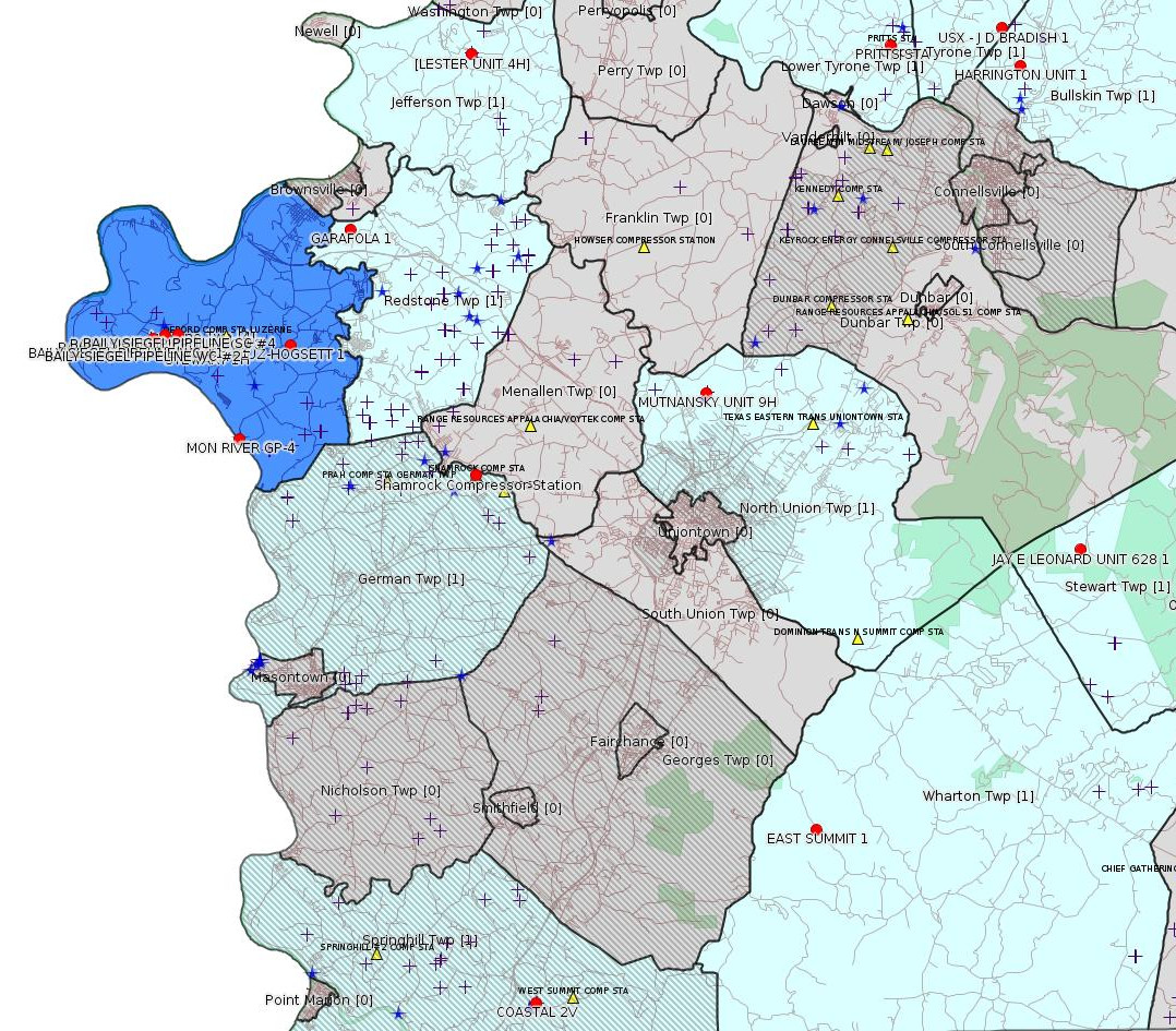
Fayette County Marcellus Shale Permits 5/2/16 - 5/15/16
Click the map to enlarge
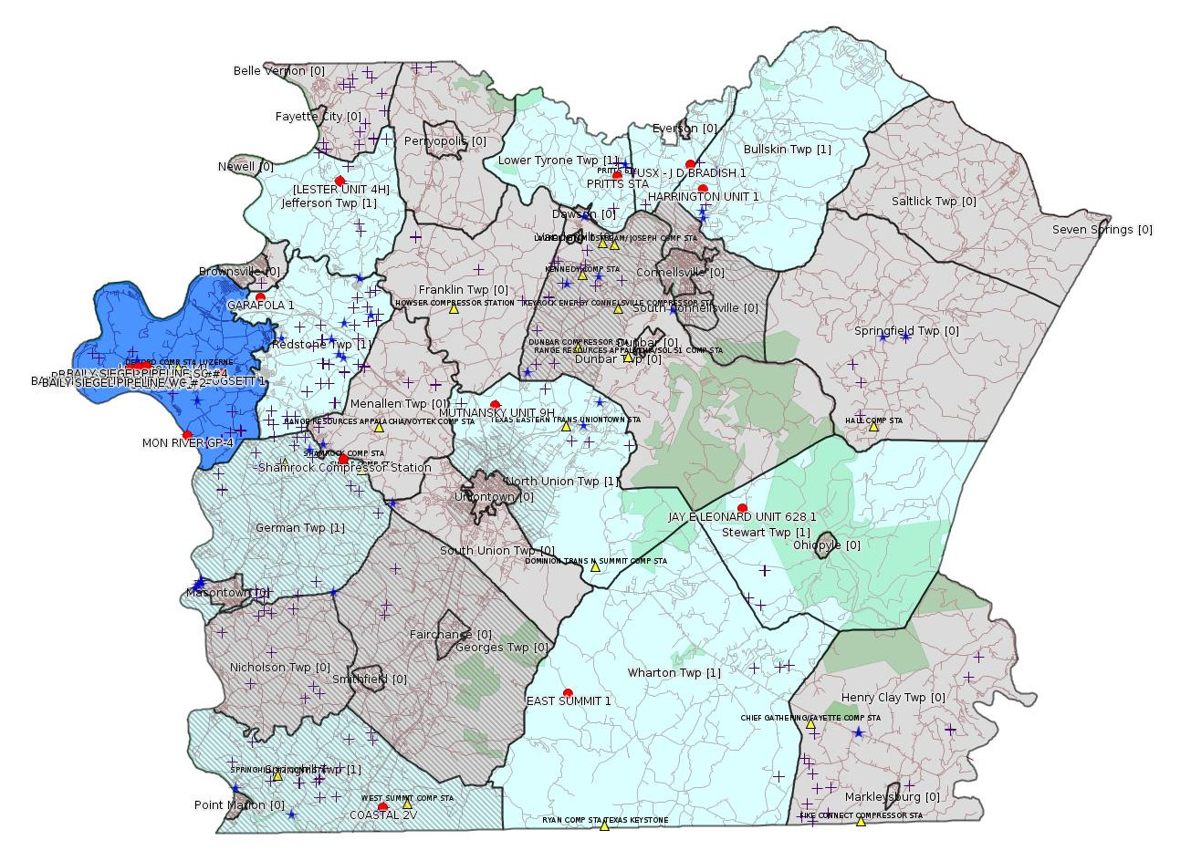
Map
Key
Red dots: items in this permit list with an exact location.
Blue stars: Marcellus Gas Well Water Sources.
Municipality shading: number of "facilities", with each well counting separately
(includes the red dots):
Red dots: items in this permit list with an exact location.
Blue stars: Marcellus Gas Well Water Sources.
Municipality shading: number of "facilities", with each well counting separately
(includes the red dots):
gray: 0
pale turquoise: 1
turquoise: 2
pale blue: 3
middle blue: 4
dark blue: 6
dark purple: 11
purple: 19
(Color coding may differ from one issue to the next.)
(Note if a project spans multiple municipalities -- e.g. a pipeline -- it will show in the count for each municipality.)
The number of facilities also follows the municipality name in brackets.
Municipality counts are based on the way the permit is listed by DEP; DEP has been known to get a municipality wrong.
Locations in brackets identify a precise location used to locate a surrogate for the actual site being permitted (e.g. locating a well pad or pipeline by the known location of a well.) Locations labeled beginning with "~" and ending in "[?]" are approximate and speculative based on inferences using on-line property and lease records. These are marked in the text as "[Approximate, Speculative]
Cross-hatching: Environmental Justice Areas
Yellow triangles: Compressor Stations
Crosses: Unconventional well permits (may not have been drilled)
Green: "Natural areas", e.g. state game lands, state forests
Yellow triangles: Compressor Stations
Crosses: Unconventional well permits (may not have been drilled)
Green: "Natural areas", e.g. state game lands, state forests
More Maps
 |
 |
Source: Pennsylvania Bulletin
NOTICES
INDEPENDENT REGULATORY REVIEW COMMISSION
Action Taken By The Commission
[46 Pa.B. 2384]
[Saturday, May 7, 2016]
The Independent Regulatory Review Commission met publicly at 9 a.m., Thursday, April 21, 2016, and ann- ounced the following:
Action Taken—Regulations Approved: [Excerpt]
Environmental Quality Board # 7-484: Environmental Protection Performance Standards at Oil and Gas Well Sites (amends 25 Pa. Code (Chapter 78))
Approval Order
Public Meeting Held
April 21, 2016
Commissioners Voting: George D. Bedwick, Chairperson; John F. Mizner, Esq., Vice Chairperson, dissenting; W. Russell Faber, dissenting; Murray Ufberg, Esq.; Dennis A. Watson, Esq.
Environmental Quality Board—
Environmental Protection Performance Standards at
Oil and Gas Well Sites
Regulation No. 7-484 (# 3042)
On December 4, 2013, the Independent Regulatory Review Commission (Commission) received this proposed regulation from the Environmental Quality Board (EQB). This rulemaking amends 25 Pa. Code (Chapter 78). The proposed regulation was published in the December 14, 2013 Pennsylvania Bulletin with a 60-day public comment period. The final-form regulation was submitted to the Commission on March 3, 2016.
This regulation updates requirements regarding surface activities associated with the development of oil and gas wells and contains new environmental protections.
We have determined this regulation is consistent with the statutory authority of EQB (2012 Oil and Gas Act; Clean Streams Law; Solid Waste Management Act; Dam Safety and Encroachments Act; Pennsylvania Land Recycling and Environmental Remediation Standards Act; Radiation Protection Act; and Unconventional Well Report Act) and the intention of the General Assembly. Having considered all of the other criteria of the Regulatory Review Act, we find promulgation of this regulation is in the public interest.
By Order of the Commission:
This regulation is approved.
GEORGE D. BEDWICK,
Chairperson
<http://www.pabulletin.com/secure/data/vol46/46-19/801.html>
---
26-00588: Laurel Mountain Midstream Operating, LLC (1550 Coraopolis Heights Road, Suite 140, Moon Township, PA 15108) Extension effective April 28, 2016, to extend the period of temporary operation of the three new ultra lean burn natural gas-fired compressor engines rated at 1,380 bhp each and controlled by oxidation catalysts, and the natural gas-fired turbine rated at 15,525 bhp covered under plan approval PA-26-00588 until September 28, 2016, at Shamrock Compressor Station located in German Township, Fayette County.
<http://www.pabulletin.com/secure/data/vol46/46-19/789c.html>
Location: 39.918333,-79.825 <http://osm.org/go/ZWpasXGm--?m=>
Municipalities: German Twp [an Environmental Justice Area]
Parcel ID: 15140026
---
26-00588A: Laurel Mountain Midstream Operating, LLC (1550 Coraopolis Heights Road, Suite 140, Moon Township, PA 15108) Extension effective April 28, 2016, to extend the period of temporary operation of the new dehydrator and emergency generator under PA-26-00588A until September 28, 2016, at Shamrock Compressor Station located in German Township, Fayette County. One Solar Titan 130 turbine rated at 19,553 HP and originally authorized to be installed at this facility under PA-26-00588A is no longer authorized as the 18-month period to commence construction specified under 25 Pa. Code § 127.13(b) has passed.
<http://www.pabulletin.com/secure/data/vol46/46-19/789c.html>
---
ESCGP-2 No: ESX15-051-0013
Applicant Name: Laurel Mountain Midstream LLC
Contact Person Stephanie Ranker
Address: 111 Enterprise Lane
City: Connellsville State: PA Zip Code: 15425
County: Fayette Township: Luzerne
Receiving Stream (s) and Classifications: UNT 1 to TRIB
40973 to Bates Run, TRIB 40973 to Bates Run, UNT 1
to Hereford Hollow, TRIB 41001 to Hereford Hollow,
UNT 2 to TRIB 41001 to Hereford Hollow, Hereford
Hollow, UNT 1 to Kelley Run, and Kelley Run/Lower
Monongahela Watershed; Other WWF
<http://www.pabulletin.com/secure/data/vol46/46-20/827c.html>
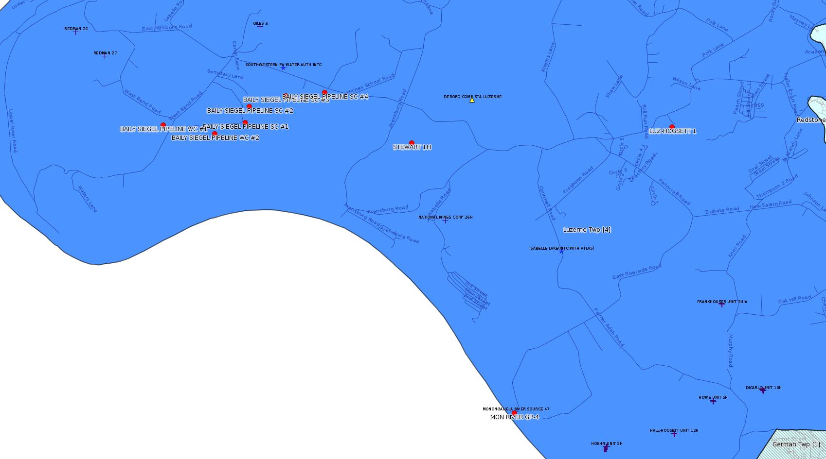
Site: BAILY SIEGEL PIPELINE ESCGP-2 EXPEDITED
Locations [from the entry for authorization 1103641 in the 4/3/16 issue of this bulletin]:
SC1: 39.965520,-79.971594 <http://osm.org/go/ZWpZF4Ki--?m=>
SC2: 39.967335,-79.970931
SC3: 39.968542,-79.965531
SC4: 39.968830,-79.959744
WC1: 39.965336,-79.983714
WC2: 39.964291,-79.976136 <http://osm.org/go/ZWpZFODT--?m=>
Municipalities: Luzerne Twp
Presumed Parcel IDs Include [See Notes]: 19240004, 1924000401, 19240014, 19240019, 19240018, 1924006701 [??]
-------------------------
Source: eNOTICE (+ PA Oil and Gas Mapping) Please see the Disclaimer below regarding Parcel Id data.
[Conventional Well:]
Authorization ID: 1135761
Permit number: 051-21193
Site: USX J D BRADISH 1 OG WELL
Client: KEYROCK ENERGY LLC
Authorization type: Well Plugging Notice Intent to Plug Single Well
Application type: New
Authorization is for: FACILITY
Date received: 04/22/2016
Status: Pending
Sub-Facility ID Sub-Facility Name Description
523611 USX - J D BRADISH 1 Well
<http://www.ahs.dep.pa.gov/eFACTSWeb/searchResults_singleAuth.aspx?AuthID=1135761>
Location: 40.071913,-79.58292 <http://osm.org/go/ZWp90Wf7--?m=>
Municipalities: Upper Tyrone Twp
Presumed Parcel Id: 39140011
[See Notes.]
Authorization ID: 1085249
Permit number: GP04260715001
Site: MONONGAHELA RIVER (4-H) WATER WITHDRAWAL PROJECT GP4
Client: CHEVRON APPALACHIA LLC
Authorization type: GP-04 Intake & Outfall Structures
Application type: New
Authorization is for: FACILITY
Date received: 07/23/2015
Status: Issued on 5/5/2016
Sub-Facility ID Sub-Facility Name Description
1183139 MON RIVER GP-4 Intake Structure
<http://www.ahs.dep.pa.gov/eFACTSWeb/searchResults_singleAuth.aspx?AuthID=1085249>
Location: 39.931997,-79.932245 <http://osm.org/go/ZWpYxPCq--?m=>
Municipalities: Luzerne Twp
Presumed Parcel Id: 19320055 ??
[Conventional Well:]
Authorization ID: 1134239
Permit number: 051-20681
Site: HARRINGTON UNIT 1 WELL
Client: KEYROCK ENERGY LLC
Authorization type: Well Plugging Notice Intent to Plug Single Well
Application type: New
Authorization is for: FACILITY
Date received: 04/15/2016
Status: Issued on 5/3/2016
Sub-Facility ID Sub-Facility Name Description
56859 HARRINGTON UNIT 1 Well
<http://www.ahs.dep.pa.gov/eFACTSWeb/searchResults_singleAuth.aspx?AuthID=1134239>
Location: 40.058513,-79.574922 <http://osm.org/go/ZWp9wvNa--?m=>
Municipalities: Bullskin Twp
Presumed Parcel Id: 04280072
[Conventional Well:]
Authorization ID: 1134263
Permit number: 051-21190
Site: LUZ HOGSETT 1 OG WELL
Client: KEYROCK ENERGY LLC
Authorization type: Well Plugging Notice Intent to Plug Single Well
Application type: New
Authorization is for: FACILITY
Date received: 04/15/2016
Status: Issued on 5/3/2016
Sub-Facility ID Sub-Facility Name Description
522268 LUZ-HOGSETT 1 Well
<http://www.ahs.dep.pa.gov/eFACTSWeb/searchResults_singleAuth.aspx?AuthID=1134263>
Location: 39.964415,-79.90832 <http://osm.org/go/ZWpZtklJ--?m=>
Municipalities: Luzerne Twp
Presumed Parcel Id: 19250070
Authorization ID: 1136282
Permit number: 051-24621
Site: STEWART WELL SITE ESCGP-2 EXPEDITED
Client: CHEVRON APPALACHIA LLC
Authorization type: Drill & Operate Well Permit Drill Deeper
Application type: New
Authorization is for: FACILITY
Date received: 04/29/2016
Status: Pending
Sub-Facility ID Sub-Facility Name Description
1211522 STEWART 1H Well
<http://www.ahs.dep.pa.gov/eFACTSWeb/searchResults_singleAuth.aspx?AuthID=1136282>
Location: 39.962961,-79.946955 <http://osm.org/go/ZWpZPAL7--?m=>
Municipalities: Luzerne Twp
Presumed Parcel Id: 19250010
Conservation Well: N
SPUD Date: 9/2/2015
Original (Drill & Operate Well) Full Permit:
<http://www.depgis.state.pa.us/PaOilAndGasMapping/PdFFetcher.ashx?Doc=FXcU5e%2fISP%2f087MkEb%2fo7A%3d%3d&ext=PDF>
[See Notes.]
Authorization ID: 1136302
Permit number: 051-24621
Site: STEWART WELL SITE ESCGP-2 EXPEDITED
Client: CHEVRON APPALACHIA LLC
Authorization type: Alt Method of Equipping, Casing, or Venting Well
Application type: New
Authorization is for: FACILITY
Date received: 04/29/2016
Status: Pending
Sub-Facility ID Sub-Facility Name Description
1211522 STEWART 1H Well
<http://www.ahs.dep.pa.gov/eFACTSWeb/searchResults_singleAuth.aspx?AuthID=1136302>
[Conventional Well:]
Authorization ID: 1132027
Permit number: 051-20051
Site: JAY E LEONARD UNIT 1 OG WELL
Client: XTO ENERGY INC
Authorization type: Well Plugging Notice Intent to Plug Single Well
Application type: New
Authorization is for: FACILITY
Date received: 03/15/2016
Status: Pending
Sub-Facility ID Sub-Facility Name Description
56258 JAY E LEONARD UNIT 628 1 Well
<http://www.ahs.dep.pa.gov/eFACTSWeb/searchResults_singleAuth.aspx?AuthID=1132027>
Location: 39.889047,-79.551017 <http://osm.org/go/ZWpt7Qzi--?m=>
Municipalities: Stewart Twp
Presumed Parcel ID: 37060019
Authorization ID: 1132028
Permit number: 051-20051
Site: JAY E LEONARD UNIT 1 OG WELL
Client: XTO ENERGY INC
Authorization type: Well Plugging Notice Alternate Method
Application type: New
Authorization is for: FACILITY
Date received: 04/05/2016
Status: Pending
Sub-Facility ID Sub-Facility Name Description
56258 JAY E LEONARD UNIT 628 1 Well
<http://www.ahs.dep.pa.gov/eFACTSWeb/searchResults_singleAuth.aspx?AuthID=1132028>
Authorization ID: 1136973
Permit number: GP5-26-00578C
Site: PRITTS STA
Client: LAUREL MTN MIDSTREAM OPR LLC
Authorization type: AQ General Permit
Application type: New
Authorization is for: FACILITY
Date received: 05/10/2016
Status: Pending
<http://www.ahs.dep.pa.gov/eFACTSWeb/searchResults_singleAuth.aspx?AuthID=1136973>
Location: 40.066216,-79.633629 <http://osm.org/go/ZWp370n6--?m=>
Municipalities: Lower Tyrone Twp
Parcel Id: 1808001301
Fayette County Act 14 Notification: <http://faymarwatch.org/documents/Pritts_NOI_GP5-26-00578C.pdf>
[See Notes.]
[Conventional Well:]
Authorization ID: 1134271
Permit number: 051-21230
Site: GARAFOLA 1 OG WELL
Client: KEYROCK ENERGY LLC
Authorization type: Well Plugging Notice Intent to Plug Single Well
Application type: New
Authorization is for: FACILITY
Date received: 04/15/2016
Status: Pending
Sub-Facility ID Sub-Facility Name Description
533284 GARAFOLA 1 Well
<http://www.ahs.dep.pa.gov/eFACTSWeb/searchResults_singleAuth.aspx?AuthID=1134271>
Location: 40.004581,-79.880819 <http://osm.org/go/ZWpeGQ1h--?m=>
Municipalities: Redstone Twp
Presumed Parcel Id: 30040220
Authorization ID: 1137133
Permit number: ESX10-051-0023
Site: LESTER WELL SITES ESCGP-EXPEDITED
Client: CHEVRON APPALACHIA LLC
Authorization type: Expedited E&S Stormwater General Permit 1
Application type: Notification
Authorization is for: SITE
Date received: 05/11/2016
Status: Pending
<http://www.ahs.dep.pa.gov/eFACTSWeb/searchResults_singleAuth.aspx?AuthID=1137133>
Location [of LESTER UNIT 4H]: 40.065558,-79.824722 <http://osm.org/go/ZWpf5Ta7--?m=>
Municipalities: Jefferson Twp
Presumed Parcel Id: 1702003801
Authorization ID: 1107917
Permit number: 051-24636
Site: COASTAL 1H FLOW BACK PIT FRESHWATER PITS ESCGP-EXPEDITED
Client: BURNETT OIL CO INC
Authorization type: Drill & Operate Well Permit
Application type: New
Authorization is for: FACILITY
Date received: 02/10/2016
Status: Pending
Sub-Facility ID Sub-Facility Name Description
1205967 COASTAL 2V Well
<http://www.ahs.dep.pa.gov/eFACTSWeb/searchResults_singleAuth.aspx?AuthID=1107917>
Location: 39.733336,-79.800886
Presumed Parcel Id: 36210048
Municipalities: Springhill Twp [an Environmental Justice Area]
Conservation Well: Y
Unconventional Well: N
-------------------------
Source: DEP Oil and Gas Compliance Report
OPERATOR: CHEVRON APPALACHIA LLC
INSPECTION_ID: 2483683
INSPECTION_DATE: 04/26/2016
INSPECTION_TYPE: Routine/Complete Inspection
API_PERMIT: 051-24420
FARM_NAME: MUTNANSKY UNIT 9H
UNCONVENTIONAL: Y
SITE_ID: 743896
SITE_NAME: MUTNANSKY UNIT 12H OG WELL
FACILITY_TYPE: Oil & Gas Location
INSPECTION_CATEGORY: Primary Facility
REGION: EP DOGO SWDO Dstr Off
COUNTY: Fayette
MUNICIPALITY: North Union Twp
INSPECTOR: NAJEWICZ, JUSTIN
INSPECTION_RESULT_DESCRIPTION: Violation(s) Noted
INSPECTION_COMMENT: "
On 10/14/15 I conducted a complaint inspection of the Mutnansky Unit in response to a complaint alleging that erosion had occurred at the site. At the time of inspection significant accelerated erosion was present. It was highly recommended that the issues present be addressed. I met with Mike Herman of Chevron at the site and he indicated that Chevron would be moving forward to address the issues at the site.
On 04/26/16 at approximately 1330 hours I conducted a routine complete inspection of the Mutnansky Unit. The Act 9 sign was in place and all required documents were present at the site. The accelerated erosion noted on 10/14/15 had not been repaired. It appears that a location part way up the pad slope was saturated and was the origin of the accelerated erosion. It is highly recommended that this be investigated.
"
VIOLATION_ID: 759143
VIOLATION_DATE: 04/26/2016
VIOLATION_CODE: 102.22(a) - SITE STABILIZATION – PERMANENT STABILIZATION – Permitee failed to have site permanently stabilized and protected from accelerated erosion and sedimentation upon final completion of earth disturbance activity.
VIOLATION_TYPE: Environmental Health & Safety
VIOLATION_COMMENT:
RESOLVED_DATE:
RESOLUTION_REASON_CODE_DESCRIPTION:
ENFORCEMENT_ID: 342870
ENFORCEMENT_CODE_DESCRIPTION: NOV - Notice of Violation
DATE_EXECUTED: 05/13/2016
ENFORCEMENT_FINAL_DATE:
ENFORCEMENT_FINAL_STATUS:
PENALTY_FINAL_DATE:
PENALTY_FINAL_STATUS_CODE_DESCRIPTION:
PENALTY_AMOUNT:
TOTAL_AMOUNT_COLLECTED:
Location: 39.945839,-79.719894 <http://osm.org/go/ZWpw~3m6--?m=>
Presumed Parcel Id: 25060068
---
[Conventional Well:]
OPERATOR: CNX GAS CO LLC
INSPECTION_ID: 2480268
INSPECTION_DATE: 05/03/2016
INSPECTION_TYPE: Follow-up Inspection
API_PERMIT: 051-22199
FARM_NAME: EAST SUMMIT 1
UNCONVENTIONAL: N
SITE_ID: 634068
SITE_NAME: EAST SUMMIT 1 OG WELL
FACILITY_TYPE: Oil & Gas Location
INSPECTION_CATEGORY: Primary Facility
REGION: EP DOGO SWDO Dstr Off
COUNTY: Fayette
MUNICIPALITY: Wharton Twp
INSPECTOR: LEWIS, RICHARD
INSPECTION_RESULT_DESCRIPTION: Violation(s) Noted
INSPECTION_COMMENT: Upon investigation of Inactive Status and Inspection on site,this well appears to be "Abandoned" since 2013. No production reported to Pa. DEP Oil & GAS Reporting System since 2013. § 3203. 78.91. General provisions (a) Upon abandoning a well, the owner or operator shall plug the well under § § 78.92—78.98 or an approved alternate method under section 211 of the act(58 P. S. § 601.211) to stop the vertical flow of fluids or gas within the well bore.
VIOLATION_ID: 758295
VIOLATION_DATE: 05/03/2016
VIOLATION_CODE: 78.91(a) - PLUGGING - GENERAL PROVISIONS - Upon abandoning a well, the owner or operator failed to plug the well to stop the vertical flow of fluids or gas within the well bore under 25 Pa. Code ?? 78.92 ? 78.98 or an approved alternate method.
VIOLATION_TYPE: Environmental Health & Safety
VIOLATION_COMMENT:
RESOLVED_DATE:
RESOLUTION_REASON_CODE_DESCRIPTION:
ENFORCEMENT_ID: 342445
ENFORCEMENT_CODE_DESCRIPTION: NOV - Notice of Violation
DATE_EXECUTED: 05/03/2016
ENFORCEMENT_FINAL_DATE:
ENFORCEMENT_FINAL_STATUS:
PENALTY_FINAL_DATE:
PENALTY_FINAL_STATUS_CODE_DESCRIPTION:
PENALTY_AMOUNT:
TOTAL_AMOUNT_COLLECTED:
Location: 39.792547,-79.673057 <http://osm.org/go/ZWpjP~~_--?m=>
-------------------------
Source: Reuters Commodities: Energy
Natural Gas
| Commodity | Exchange | Currency | Expire | Last Trade | Trade Time | Change | Open | Day's High | Day's Low |
|---|---|---|---|---|---|---|---|---|---|
| NATURAL
GAS CON1 May16 |
NYM | USD | 05/26 | 2.04 | 05/16 18:40 | +0.01 | 2.04 | 2.04 | 2.04 |
-------------------------
Notes:
For a pipeline permit, the list labeled "Presumed Parcel IDs Include" is derived from those locations where DEP has listed a latitude and longitude (e.g. stream crossings) together with some parcels whose ID may be able to be inferred by interpolation. Such a list may be incomplete.
The previous issue of this bulletin carried the notice that authorization 1132078 for this exact same well, USX J D BRADISH 1 OG WELL, and for the exact same authorization type, "Well Plugging Notice Intent to Plug Single Well", was already issued on 4/14/2016. Why there is a second authorization for the same well and the same type is a mystery.
Permit applications of type "Drill & Operate Well Permit Drill Deeper" call for special scrutiny. Despite the apparent meaning of "Drill Deeper", we have seen in many cases that what these applications really mean is that the well is being done over. Close examination of all inspection reports for the well pad in question often reveals an anomaly of one kind or another; among the issues that have shown up just in Fayette County are cement problems, horizontal failed due to an unanticipated geological fault, and an unacknowledged underground explosion. (Such anomalies are typically only shown in the comment field of inspection reports, and are not written up as violations for the actual anomaly in question. In fact usually there is no violation at all.) In the case of authorization 1136282 above, while we don't seem to have an anomaly for Stewart 1H, there is an anomaly for Stewart 2H, i.e. a cementing problem. The 11/1/15 issue of this bulletin shows the following entry from the DEP Oil & Gas Compliance Report:
OPERATOR: CHEVRON APPALACHIA LLC
INSPECTION_ID: 2419580
INSPECTION_DATE: 10/23/2015
INSPECTION_TYPE: Drilling/Alteration
API_PERMIT: 051-24628
FARM_NAME: STEWART 2H
UNCONVENTIONAL: Y
SITE_ID: 788124
SITE_NAME: STEWART WELL SITE ESCGP-2 EXPEDITED
FACILITY_TYPE: Oil & Gas Location
INSPECTION_CATEGORY: Primary Facility
REGION: EP DOGO SWDO Dstr Off
COUNTY: Fayette
MUNICIPALITY: Luzerne Twp
INSPECTION_RESULT_DESCRIPTION: No Violations Noted
INSPECTION_COMMENT: HORIZONTAL MARCELLUS, Drilling on air @ 3197' (TD). Setting Intermediate Casing and cementing tonight (10/23/2015). During cementing of casing loss circulation occurred at end of job. Operator has agree to (CBL) to determine top of cement.
"CBL" stands for Cement Bonding Log. It is a kind of down-hole sonogram that can reveal flaws in the cement job.
---
The most recent prior permit for the Pritts Compressor Station was issued in 2011, as listed in PA Bulletin [41 Pa.B. 3739], [Saturday, July 9, 2011]:
GP5-26-00578B: Laurel Mountain Midstream, LLC (1550 Coraopolis Height Road, 2nd Floor, Moon Township, PA 15108) on June 17, 2011, to allow modification and operation of a natural gas production facility with the addition of five lean burn natural gas-fired compressor engines rated at 1,380 bhp each controlled by oxidation catalysts, and two 30 MMscfd dehydration units with reboilers rated at 0.5 MMBtu/hr and controlled by a flare. The facility will be authorized under GP-5 for natural gas production at the Pritts Compressor Station located in Lower Tyrone Township, Fayette County.
<http://www.pabulletin.com/secure/data/vol41/41-28/1137c.html>
That makes altogether 6 compression engines as of 2011. The current application is apparently in lieu of a straight renewal; LMM is reducing the facility to one compression engine, one dehydrator, and a flare (and other miscellaneous equipment). For details see the NOI listed above.
------------------------
DEP defines an environmental justice area as "any census tract where 20 percent or more individuals live in poverty, and/or 30 percent or more of the population is minority". (See:
<http://www.portal.state.pa.us/portal/server.pt/community/pa_environmental_justice_areas/20991>
<http://www.portal.state.pa.us/portal/server.pt/community/dep_enhanced_public_participation_policy/20988>
). There are supposed to be enhanced public participation requirements for permits in environmental justice areas, but news of this actually ever happening is scarce. In Fayette County, the entirety of Springhill, Nicholson, German, and Georges Townships are environmental justice areas, as well as a large part of Dunbar Township. DEP's policy document on public participation guidelines for environmental justice areas is located here:
<http://www.elibrary.dep.state.pa.us/dsweb/Get/Version-48671/012-0501-002.pdf>
eNOTICE records are likely to list the same permit multiple times, as that permit moves through the DEP process.
Oil & Gas Wells designated with a site a number and the letter H typically designate horizontal wells.
-------------------------
Resources:
Pennsylvania Bulletin: <http://www.pabulletin.com/>
eNOTICE: <http://www.ahs2.dep.state.pa.
DEP Well Details Report: <https://www.paoilandgasreport
Well Details may not show any
information for new permits and will not show permits which have
not yet been issued. Lookup for Well Details is by permit number.
DEP Permits Issued Detail Report:
<http://www.depreportingservic
DEP SPUD (drilling started) Report:
<http://www.depreportingservices.state.pa.us/ReportServer/Pages/ReportViewer.aspx?/Oil_Gas/Spud_External_Data>
DEP Oil and Gas Compliance Report:
<http://www.depreportingservices.state.pa.us/ReportServer/Pages/ReportViewer.aspx?/Oil_Gas/OG_Compliance>
DEP PA Oil & Gas Mapping:
<http://www.depgis.state.pa.us/PaOilAndGasMapping>
Fayette County Assessment Office Search For Tax Records:
<http://property.co.fayette.pa.us/search.aspx>
Pennsylvania Spatial Data Access:
<http://www.pasda.psu.edu/default.asp>
DEP Spatial Data Repository:
<ftp://www.pasda.psu.edu/pub/pasda/dep/>
National Response Center:
<http://www.nrc.uscg.mil/>
EPA-Echo: <http://www.epa-echo.gov/echo/
FERC citizen involvement: <http://www.ferc.gov/for-citiz
To receive E-mail notification of
all documents filed in a FERC docket, see:
<http://www.ferc.gov/docs-filing/esubscription.asp >
<http://www.ferc.gov/docs-fili
Follow the directions and enter the docket number to subscribe to.
Township Supervisors receive information regarding Erosion & Sedimentation permits, and these records may be reviewable at township municipal offices.
DEP permits are reviewable through the File Review process, for application to do file review see: <http://www.portal.state.pa.us/portal/server.pt/community/southwest_regional_office/13775/file_review/593164>
Environmental Hearing Board: <http://ehb.courtapps.com/publ
PA DEP Environmental Policy Comment System:
<http://www.ahs.dep.pa.gov/eComment/>
Federal Register Environment: <https://www.federalregister.g
Browsing of recent comment
opportunities for federal agencies, e.g. EPA. Click "sign up" to
subscribe to daily E-mails of new document listings.
SkyTruth Fayette County Drilling Alerts: <http://frack.skytruth.org/pen
EPA Pennsylvania Public Notices: <http://www2.epa.gov/aboutepa/epa-pennsylvania#notice>
Marcellus Shale waste disposal
injection wells in Pennsylvania are regulated directly by EPA, not
DEP. Notice of any new permit applications will appear at the
above web address. I'm not aware of any subscription service
to be notified of such applications. I'm not aware of any
Marcellus Shale waste disposal injection wells in Fayette County
(yet ...) but we need to monitor this page for future
applications.
Energy Assurance Daily: <http://www.oe.netl.doe.gov/ead.aspx>
Daily newsletter from the US
Department of Energy about events relating to energy. The Natural
Gas section has information about pipelines.
-------------------------
Disclaimers:
This compilation from the above sources was done by hand using copy and paste and may omit relevant permits.
Parcel data is provided via the tax records search web page offered by the Fayette County Assessment Office (http://property.co.fayette.pa.us/). Presumed Parcel Id links are subject to availability provided by that agency and associated web sites. Presumed Parcel Ids are determined as the mapped parcel containing a given latitude and longitude, are a best effort determination which is subject to error, and are not official. In cases where a facility is leased and there is a separate parcel id for the lease, if this parcel id is not separately mapped, the parcel id shown will be the id for the enclosing parcel. Parcel owners may be surface owners only and may or may not have any relationship to oil & gas facilities.
Does not currently include water supply permits. Does not include landfill permits even though many such are for Marcellus Shale waste. (It is not possible at this time to distinguish which landfill permits are for Marcellus Shale waste and which are not without doing File Review for each permit.)
Erosion & Sedimentation permit records do not currently include latitude and longitude. Where I am publishing latitude and longitude with E&S permits it is by inferring an associated well permit and using published latitude and longitude for the well. It is possible I may be inferring the wrong well site.
Municipalities are shown from eFACTS records on the DEP web site. The DEP has been known to list a municipality incorrectly.