The Harmed Success Stories Concepts How To What Is Commentary
Fayette County Marcellus Shale Permits 5/15/17 - 5/28/17
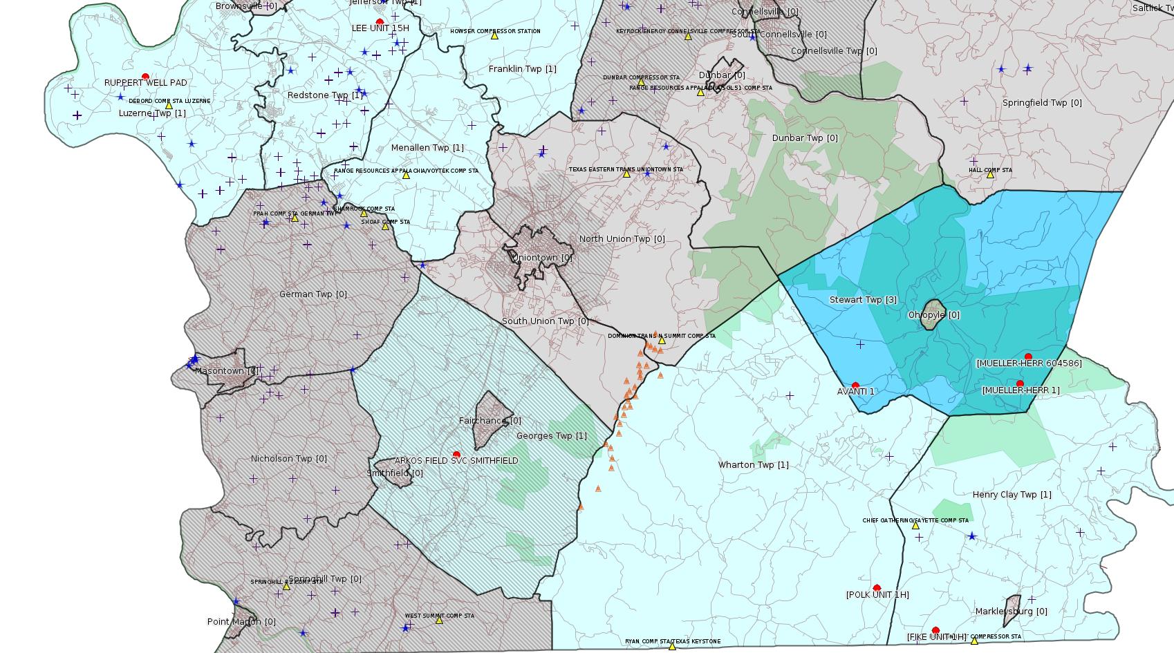
Click the map to enlarge
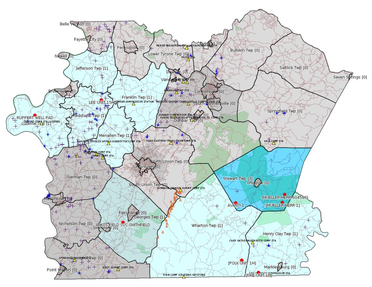
Map
Key
Red dots: items in this permit list with an exact location.
Blue stars: Marcellus Gas Well Water Sources.
Municipality shading: number of "facilities", with each well counting separately
(includes the red dots):
Red dots: items in this permit list with an exact location.
Blue stars: Marcellus Gas Well Water Sources.
Municipality shading: number of "facilities", with each well counting separately
(includes the red dots):
gray: 0
pale turquoise: 1
turquoise: 2
pale blue: 3
middle blue: 4
dark blue: 6
dark purple: 10
purple: 19
(Color coding may differ from one issue to the next.)
(Note if a project spans multiple municipalities -- e.g. a pipeline -- it will show in the count for each municipality.)
The number of facilities also follows the municipality name in brackets.
Municipality counts are based on the way the permit is listed by DEP; DEP has been known to get a municipality wrong.
Locations in brackets identify a precise location used to locate a surrogate for the actual site being permitted (e.g. locating a well pad or pipeline by the known location of a well.) Locations labeled beginning with "~" and ending in "[?]" are approximate and speculative based on inferences using on-line property and lease records. These are marked in the text as "[Approximate, Speculative]
Cross-hatching: Environmental Justice Areas
Yellow triangles: Compressor Stations
Orange triangles: Storage Field Wells (currently Dominion North Summit Storage Field)
Crosses: Unconventional well permits (may not have been drilled)
Green: "Natural areas", e.g. state game lands, state forests
Yellow triangles: Compressor Stations
Orange triangles: Storage Field Wells (currently Dominion North Summit Storage Field)
Crosses: Unconventional well permits (may not have been drilled)
Green: "Natural areas", e.g. state game lands, state forests
More Maps
 |
Source: Pennsylvania Bulletin
ESCGP-2 # ESX17-051-0002
Applicant Name Chevron Appalachia, LLC
Contact Person Branden Weimer
Address 800 Mountain View Drive
City, State, Zip Smithfield, PA 15478
County Fayette County
Township(s) Luzerne Township
Receiving Stream(s) and Classification(s) UNTs to Rush
Run (WWF)
Secondary—Rush Run
<http://www.pabulletin.com/secure/data/vol47/47-21/883c.html>
Site: RUPPERT WELL PAD ESCGP ESX17-051-0002
Location: 39.980714,-79.951394 <http://osm.org/go/ZWpZcmDI--?m=>
Municipalities: Luzerne Twp
Act 14 Notification: <http://faymarwatch.org/documents/SKM_554e17041316431.pdf>
Presumed Parcel Id: 19150099
-------------------------
Source: eNOTICE (+ PA Oil and Gas Mapping, Well Pad Report) Please see the Disclaimer below regarding Parcel Id data.
Authorization ID: 1172242
Permit number: ESG17-051-0001
Site: LPR MIDSTREAM PARTNERS LLC POLK PIPELINE ESCGP ESG17-051-0001 & GP05 GP08
Client: LPR MIDSTREAM PARTNERS LLC
Authorization type: Erosion and Sediment Control GP-2
Application type: New
Authorization is for: SITE
Date received: 03/06/2017
Status: Pending
Permit Review Notes:
Date Review Note
5/15/2017 Applicant has been issued a deficiency letter. If applicable, this application no longer qualifies for the Permit Decision Guarantee.
<http://www.ahs.dep.pa.gov/eFACTSWeb/searchResults_singleAuth.aspx?AuthID=1172242>
Municipalities: Henry Clay Twp, Wharton Twp
Location [of POLK UNIT 1H]: 39.746494,-79.529567 <http://osm.org/go/ZWpqHRIj--?m=>
Presumed Parcel Id: 4233000106
Location [of FIKE UNIT 1H]: 39.727028 -79.495752 <http://osm.org/go/ZWpqgA7n--?m=>
Parcel Id: 16190003
Municipalities: Henry Clay Twp, Wharton Twp
Authorization ID: 1172759
Permit number: ESX11-051-0016
Site: CONSTATINE TO LYNN PIPELINE ESCGP ESX11-051-0016 & GP5
Client: LAUREL MTN MIDSTREAM OPR LLC
Authorization type: Expedited E&S Stormwater General Permit 1
Application type: Amendment
Authorization is for: SITE
Date received: 03/03/2017
Status: Pending
Permit Review Notes:
Date Review Note
5/18/2017 Applicant has been issued a deficiency letter. If applicable, this application no longer qualifies for the Permit Decision Guarantee.
<http://www.ahs.dep.pa.gov/eFACTSWeb/searchResults_singleAuth.aspx?AuthID=1172759>
Municipalities: Franklin Twp, Jefferson Twp, Menallen Twp
Authorization ID: 1183070
Permit number: GP08260717002
Site: WELL PLUGGING SITE #592217/592218 (PITTSBURGH NATIONBANK #2 AND #3)
Client: EQT PRODUCTION CO
Authorization type: GP-08 Temporary Road Crossings
Application type: New
Authorization is for: FACILITY
Date received: 05/08/2017
Status: Pending
Sub-Facilities for Authorization
Sub-Facility ID Sub-Facility Name Description eMap PA Location
1234363 WELL PLUGGING SITE PITTSBURGH NATIONAL BANK 2 &3 GP08 Bridge
<http://www.ahs.dep.pa.gov/eFACTSWeb/searchResults_singleAuth.aspx?AuthID=1183070>
Location [Speculative Association] [of MUELLER-HERR 1]: 39.837139,-79.44419
<http://osm.org/go/ZWrEQpgE--?m=>
Location [Speculative Association] [of MUELLER-HERR 604586]: 39.849219,-79.439209
<http://osm.org/go/ZWrEWMcB--?m=>
Municipalities: Stewart Twp
[See Notes.]
Authorization ID: 1109304
Permit number: PAG036154
Site: ARKOS FIELD SVC SMITHFIELD
Client: ARKOS FIELD SVC LP
Authorization type: PAG-03 Discharge of Stormwater Assoc w Industrial Activities
Application type: New
Authorization is for: FACILITY
Date received: 02/23/2016
Status: Pending
Sub-Facility ID Sub-Facility Name Description
1206640 OUTFALL 001 Discharge Point
<http://www.ahs.dep.pa.gov/eFACTSWeb/searchResults_singleAuth.aspx?AuthID=1109304>
Location: 39.809265,-79.772891 <http://osm.org/go/ZWphdqHS--?m=>
Presumed Parcel Id: 1425020722
Municipalities: Smithfield Boro [Incorrect! Should be Georges Twp [an Environmental Justice Area] -jr]
-------------------------
Source: DEP Oil and Gas Compliance Report
OPERATOR: CHEVRON APPALACHIA LLC
INSPECTION_ID: 2597216
INSPECTION_DATE: 05/19/2017
INSPECTION_TYPE: Routine/Complete Inspection
API_PERMIT: 051-24485
FARM_NAME: LEE UNIT 15H
UNCONVENTIONAL: Yes
SITE_ID: 755446
SITE_NAME: LEE UNIT 14H OG WELL
FACILITY_TYPE: Oil & Gas Location
INSPECTION_CATEGORY: Primary Facility
REGION: EP DOGO SWDO Dstr Off
COUNTY: Fayette
MUNICIPALITY: Redstone Twp
INSPECTOR: NAJEWICZ, JUSTIN
INSPECTION_SOURCE: MOBILE
INSPECTION_RESULT_DESCRIPTION: No Violations Noted
INSPECTION_COMMENT: "On 05/18 and 05/19 Chevron had Civil and Environmental Consultants (CEC) perform soil testing and vegetative analysis in response to a Complainant alleging soil compaction had occurred on the site. The Complainant had hired a consultant to conduct an investigation to look for evidence of compaction. The Department and Chevron are in possession of the report completed by the consultant post investigation.
The following CEC Representatives conducted the investigation:
Joe Isaac, CEC Project Manager and Botanist
John K. Buck, CEC CPSS Project Manager and Soil Scientist
Ryan Duke, CEC Civil Engineer
The following Chevron representatives were present at the site at varying times during the two days CEC conducted their investigation:
Todd Radolec, Chevron PE Civil Team Lead
Angela Layton, Chevron PE Facilities Engineering
Rodney Frazee, Chevron Surface Land Representative
Nick Staffieri, Chevron Regulatory Compliance Team Lead
Bernard A. Lambie, Chevron Regulatory Compliance Team Member
The Complainant was also present at varying times throughout the two days and had discussions with Chevron and CEC representatives regarding the site and scope of work. The Complainant also observed some of the soil testing being conducted.
Joe Isaac performed vegetation analysis including vegetative cover and species identification. Ryan Duke performed three Troxler tests for three separate depth ranges per each testing site. Each test was run for the maximum time of four minutes to provide the best analysis possible. John K. Buck oversaw Troxler testing, used a manual soil compaction gauge, and also collected soil samples from three different soil depths after the Troxler tests were completed. The samples will undergo soil analysis in a lab to analyze rock content via Sieve analysis in order to correct soil densities for rock content as well as to determine soil type.
During the investigation CEC found no bulk densities exceeding the range of naturally occurring, undisturbed soils. According to CEC, the bulk densities will only decrease after the results are corrected for rock content. The results of the investigation will be included in a report CEC will complete once the soil samples have been analyzed. Joe Isaac of CEC will include the vegetative cover results from his investigation in the report."
Location: 40.003908,-79.814256 <http://osm.org/go/ZWpeuHVM--?m=>
Presumed Parcel Id: 30060201
[There is an identical report for Lee Unit 14H; the inspection was evidently of the entire pad.]
-------------------------
Source: DEP Oil and Gas Electronic Notifications
NOTIFICATION_ID: 34825
OGO: 39307
OPERATOR: CHEVRON APPALACHIA LLC
API_PERMIT: 051-23958
SPUD_DATE: 05/16/2008
COUNTY: Fayette
MUNICIPALITY: Stewart
LATITUDE: 39.837527
LONGITUDE: -79.54003
SUBJECT: [NOTIFICATION]: Abandonment or plugging notification 58 Pa. C.S. 3211(f)(2) for well API 37-051-23958-00-00
QUESTION:
ANSWER:
SENT_DATE: 5/25/2017 10:18:35 AM
SENT_SUCCESS: Yes
LAST_RESENT_DATE:
RESENT_SUCCESS:
Comments:
Farm Name: AVANTI 1
Location: 39.837527,-79.54003 <http://osm.org/go/ZWpuQBy2--?m=>
Presumed Parcel Id: 37150002
SPUD Date: 5/16/2008
Well Status: Regulatory Inactive Status
Conservation Well: Y
Well Configuration: Vertical Well
Coal: Coal
WELL PAD ID: 146849
Most Recent Production Period: *Never*
[See Notes.]
---
NOTIFICATION_ID: 34680
OGO: 39307
OPERATOR: CHEVRON APPALACHIA LLC
API_PERMIT: 051-23958
SPUD_DATE: 05/16/2008
COUNTY: Fayette
MUNICIPALITY: Stewart
LATITUDE: 39.837527
LONGITUDE: -79.54003
SUBJECT: [NOTIFICATION]: Abandonment or plugging notification 58 Pa. C.S. 3211(f)(2) for well API 37-051-23958-00-00
QUESTION:
ANSWER:
SENT_DATE: 5/18/2017 12:31:16 PM
SENT_SUCCESS: Yes
LAST_RESENT_DATE:
RESENT_SUCCESS:
-------------------------
Source: Reuters Commodities: Energy
Natural Gas
| Commodity | Exchange | Currency | Expire | Last Trade | Trade Time | Change | Open | Day's High | Day's Low |
|---|---|---|---|---|---|---|---|---|---|
| NATURAL
GAS CON1 Jun17 |
NYM | USD | 06/28 | 3.21 | 05/28 22:08 | -0.09 | 3.25 | 3.26 | 3.19 |
-------------------------
Notes:
Authorization 1183070 above for EQT has very confusing metadata. The exact authorization is for a road crossing, and lists two wells, PITTSBURGH NATIONBANK #2 AND #3. There aren't wells with those names. It also shows two site numbers, which also appear to be wrong. The municipality shows as Stewart Twp, and there only seem to be two EQT wells in Stewart Twp, which are called in DEP's Oil & Gas Mapping database as MUELLER-HERR 1 and MUELLER-HERR 604586, so those are the two locations that are mapped.
---
The two electronic notifications for plugging of AVANTI 1 above appear to be defective; there should be a question/answer giving the date when the plugging is supposed to happen.
The Avanti 1 well site was the site of several violations dating to 2008 and 2009. For details see:
<http://www.ahs.dep.pa.gov/eFACTSWeb/searchResults_singleViol.aspx?InspectionID=1712825>
<http://www.ahs.dep.pa.gov/eFACTSWeb/searchResults_singleViol.aspx?InspectionID=1847524>
Fines assessed were 8400 and 7425.
------------------------
DEP defines an environmental justice area as "any census tract where 20 percent or more individuals live in poverty, and/or 30 percent or more of the population is minority". (See:
<http://www.dep.pa.gov/PublicParticipation/OfficeofEnvironmentalJustice/Pages/default.aspx>). There are supposed to be enhanced public participation requirements for permits in environmental justice areas, but news of this actually ever happening is scarce. In Fayette County, the entirety of Springhill, Nicholson, German, and Georges Townships are environmental justice areas, as well as a large part of Dunbar Township. DEP's policy document on public participation guidelines for environmental justice areas is located here:
<http://www.elibrary.dep.state.pa.us/dsweb/Get/Version-48671/012-0501-002.pdf>
eNOTICE records are likely to list the same permit multiple times, as that permit moves through the DEP process.
Oil & Gas Wells designated with a site a number and the letter H typically designate horizontal wells.
-------------------------
Resources:
Pennsylvania Bulletin: <http://www.pabulletin.com/>
eNOTICE: <http://www.ahs2.dep.state.pa.
DEP Oil and Gas Reports: <http://www.dep.pa.gov/DataandTools/Reports/Oil%20and%20Gas%20Reports/Pages/default.aspx>
DEP Well Details Report: <https://www.paoilandgasreport
Well Details may not show any
information for new permits and will not show permits which have
not yet been issued. Lookup for Well Details is by permit number.
DEP Permits Issued Detail Report:
<http://www.depreportingservic
DEP SPUD (drilling started) Report:
<http://www.depreportingservices.state.pa.us/ReportServer/Pages/ReportViewer.aspx?/Oil_Gas/Spud_External_Data>
DEP Oil and Gas Compliance Report:
<http://www.depreportingservices.state.pa.us/ReportServer/Pages/ReportViewer.aspx?/Oil_Gas/OG_Compliance>
DEP PA Oil & Gas Mapping:
<http://www.depgis.state.pa.us/PaOilAndGasMapping>
DEP Oil and Gas Electronic Notifications
<http://www.depreportingservices.state.pa.us/ReportServer?/Oil_Gas/OG_Notifications>
DEP Oil and Gas Well Pad Report
<http://www.depreportingservices.state.pa.us/ReportServer?/Oil_Gas/Well_Pads>
Fayette County Assessment Office Search For Tax Records:
<http://property.co.fayette.pa.us/search.aspx>
Pennsylvania Spatial Data Access:
<http://www.pasda.psu.edu/default.asp>
DEP Spatial Data Repository:
<ftp://www.pasda.psu.edu/pub/pasda/dep/>
National Response Center:
<http://www.nrc.uscg.mil/>
EPA-Echo: <http://www.epa-echo.gov/echo/
FERC citizen involvement: <http://www.ferc.gov/for-citiz
To receive E-mail notification of
all documents filed in a FERC docket, see:
<http://www.ferc.gov/docs-filing/esubscription.asp >
<http://www.ferc.gov/docs-fili
Follow the directions and enter the docket number to subscribe to.
Township Supervisors receive information regarding Erosion & Sedimentation permits, and these records may be reviewable at township municipal offices.
DEP permits are reviewable through the File Review process, for application to do file review see: <http://www.portal.state.pa.us/portal/server.pt/community/southwest_regional_office/13775/file_review/593164>
Environmental Hearing Board: <http://ehb.courtapps.com/publ
PA DEP Environmental Policy Comment System:
<http://www.ahs.dep.pa.gov/eComment/>
Federal Register Environment: <https://www.federalregister.g
Browsing of recent comment
opportunities for federal agencies, e.g. EPA. Click "sign up" to
subscribe to daily E-mails of new document listings.
SkyTruth Fayette County Drilling Alerts: <http://frack.skytruth.org/pen
U.S. Army Corps of Engineers, Pittsburgh District, Public Notices:
<http://www.lrp.usace.army.mil/Missions/Regulatory/Public-Notices/>
EPA Pennsylvania Public Notices: <http://www2.epa.gov/aboutepa/epa-pennsylvania#notice>
Marcellus Shale waste disposal
injection wells in Pennsylvania are regulated directly by EPA, not
DEP. Notice of any new permit applications will appear at the
above web address. I'm not aware of any subscription service
to be notified of such applications. I'm not aware of any
Marcellus Shale waste disposal injection wells in Fayette County
(yet ...) but we need to monitor this page for future
applications.
Energy Assurance Daily: <http://www.oe.netl.doe.gov/ead.aspx>
Daily newsletter from the US
Department of Energy about events relating to energy. The Natural
Gas section has information about pipelines.
-------------------------
Disclaimers:
This compilation from the above sources was done by hand using copy and paste and may omit relevant permits.
Parcel data is provided via the tax records search web page offered by the Fayette County Assessment Office (http://property.co.fayette.pa.us/). Presumed Parcel Id links are subject to availability provided by that agency and associated web sites. Presumed Parcel Ids are determined as the mapped parcel containing a given latitude and longitude, are a best effort determination which is subject to error, and are not official. In cases where a facility is leased and there is a separate parcel id for the lease, if this parcel id is not separately mapped, the parcel id shown will be the id for the enclosing parcel. Parcel owners may be surface owners only and may or may not have any relationship to oil & gas facilities.
Does not currently include water supply permits. Does not include landfill permits even though many such are for Marcellus Shale waste. (It is not possible at this time to distinguish which landfill permits are for Marcellus Shale waste and which are not without doing File Review for each permit.)
Erosion & Sedimentation permit records do not currently include latitude and longitude. Where I am publishing latitude and longitude with E&S permits it is by inferring an associated well permit and using published latitude and longitude for the well. It is possible I may be inferring the wrong well site.
Municipalities are shown from eFACTS records on the DEP web site. The DEP has been known to list a municipality incorrectly.