The Harmed Success Stories Concepts How To What Is Commentary
Fayette County Marcellus Shale Permits 5/29/17 - 6/11/17
Click the map to enlarge
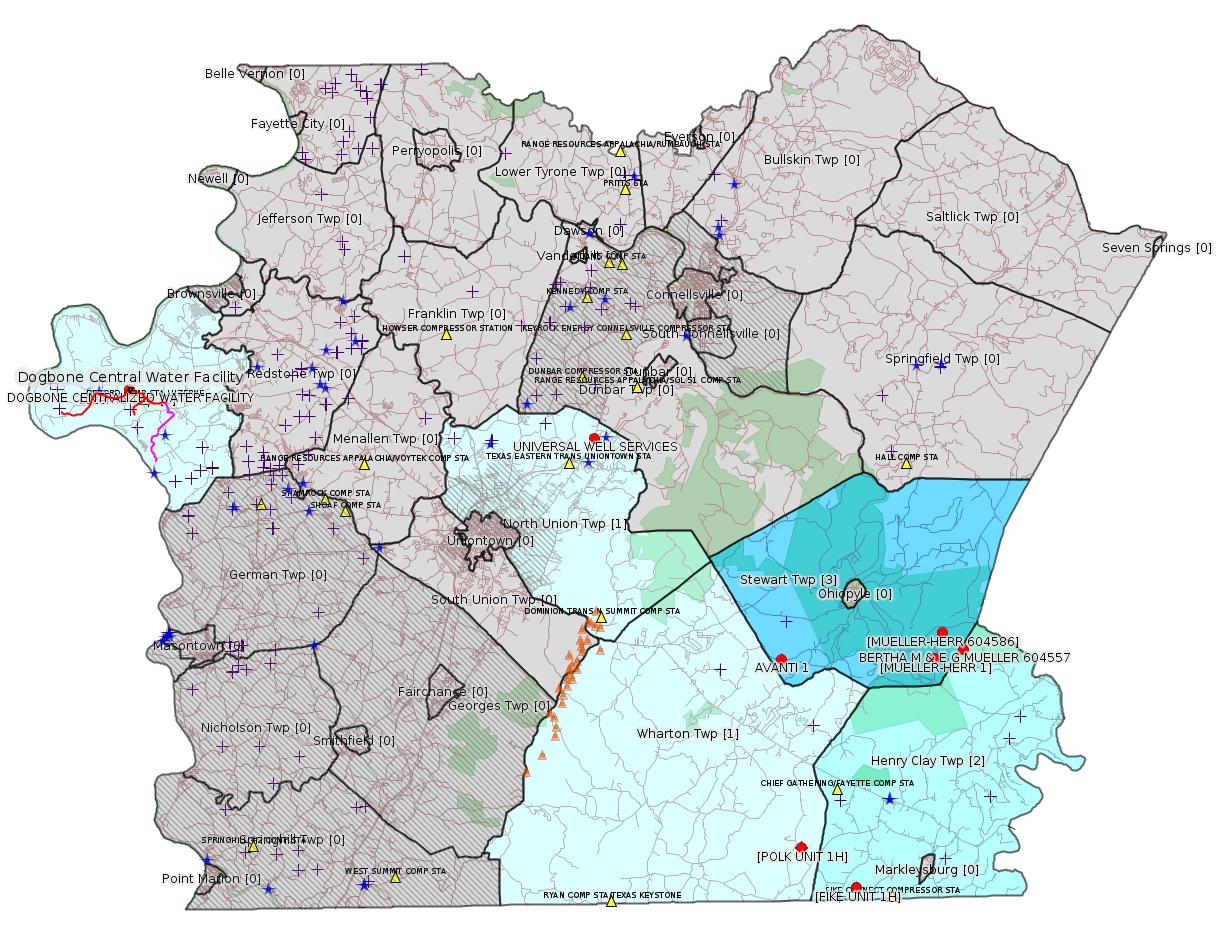
Map
Key
Red dots: items in this permit list with an exact location.
Blue stars: Marcellus Gas Well Water Sources.
Municipality shading: number of "facilities", with each well counting separately
(includes the red dots):
Red dots: items in this permit list with an exact location.
Blue stars: Marcellus Gas Well Water Sources.
Municipality shading: number of "facilities", with each well counting separately
(includes the red dots):
gray: 0
pale turquoise: 1
turquoise: 2
pale blue: 3
middle blue: 4
dark blue: 6
dark purple: 10
purple: 19
(Color coding may differ from one issue to the next.)
(Note if a project spans multiple municipalities -- e.g. a pipeline -- it will show in the count for each municipality.)
The number of facilities also follows the municipality name in brackets.
Municipality counts are based on the way the permit is listed by DEP; DEP has been known to get a municipality wrong.
Locations in brackets identify a precise location used to locate a surrogate for the actual site being permitted (e.g. locating a well pad or pipeline by the known location of a well.) Locations labeled beginning with "~" and ending in "[?]" are approximate and speculative based on inferences using on-line property and lease records. These are marked in the text as "[Approximate, Speculative]
Cross-hatching: Environmental Justice Areas
Yellow triangles: Compressor Stations
Orange triangles: Storage Field Wells (currently Dominion North Summit Storage Field)
Crosses: Unconventional well permits (may not have been drilled)
Green: "Natural areas", e.g. state game lands, state forests
Yellow triangles: Compressor Stations
Orange triangles: Storage Field Wells (currently Dominion North Summit Storage Field)
Crosses: Unconventional well permits (may not have been drilled)
Green: "Natural areas", e.g. state game lands, state forests
More Maps
 |
 |
 |
Source: Pennsylvania Bulletin
[No Activity]
-------------------------
Source: eNOTICE (+ PA Oil and Gas Mapping, Well Pad Report) Please see the Disclaimer below regarding Parcel Id data.
Authorization ID: 1174654
Permit number: GP05260717-001
Site: LPR MIDSTREAM PARTNERS LLC POLK PIPELINE ESCGP ESG17-051-0001 & GP05 GP08
Client: LPR MIDSTREAM PARTNERS LLC
Authorization type: GP-05 Utility Line Stream Crossings
Application type: New
Authorization is for: FACILITY
Date received: 03/01/2017
Status: Pending
Sub-Facility ID Sub-Facility Name Description
1230294 POLK PIPELINE PROJECT GP05260717-001 Pipeline or Conduit
Permit Review Notes:
Date Review Note
4/10/2017 Applicant has been issued a deficiency letter. If applicable, this application no longer qualifies for the Permit Decision Guarantee.
<http://www.ahs.dep.pa.gov/eFACTSWeb/searchResults_singleAuth.aspx?AuthID=1174654>
Municipalities: Henry Clay Twp, Wharton Twp
Location [of POLK UNIT 1H]: 39.746494,-79.529567 <http://osm.org/go/ZWpqHRIj--?m=>
Presumed Parcel Id: 4233000106
Location [of FIKE UNIT 1H]: 39.727028 -79.495752 <http://osm.org/go/ZWpqgA7n--?m=>
Parcel Id: 16190003
Authorization ID: 1174655
Permit number: GP08260717-001
Site: LPR MIDSTREAM PARTNERS LLC POLK PIPELINE ESCGP ESG17-051-0001 & GP05 GP08
Client: LPR MIDSTREAM PARTNERS LLC
Authorization type: GP-08 Temporary Road Crossings
Application type: New
Authorization is for: FACILITY
Date received: 03/01/2017
Status: Pending
Sub-Facility ID Sub-Facility Name Description
1230296 POLK PIPELINE PROJECT GP08260717-001 Bridge
Permit Review Notes:
Date Review Note
4/10/2017 Applicant has been issued a deficiency letter. If applicable, this application no longer qualifies for the Permit Decision Guarantee.
<http://www.ahs.dep.pa.gov/eFACTSWeb/searchResults_singleAuth.aspx?AuthID=1174655>
[Conventional Well:]
Authorization ID: 1184291
Permit number: 051-20011
Site: BERTHA M & E G MUELLER 604557 WELL
Client: EQT PRODUCTION CO
Authorization type: Well Plugging Notice Intent to Plug Single Well
Application type: New
Authorization is for: FACILITY
Date received: 05/31/2017
Status: Issued on 5/31/2017
Sub-Facility ID Sub-Facility Name Description
56218 BERTHA M & E G MUELLER 604557 Well
<http://www.ahs.dep.pa.gov/eFACTSWeb/searchResults_singleAuth.aspx?AuthID=1184291>
Location: 39.84126,-79.42603 <http://osm.org/go/ZWrEYfis--?m=>
Parcel Id: 16010001
Municipality: Henry Clay Twp
SPUD Date: 1959-08-29
Conservation Well: N
Coal: NonCoal
Authorization ID: 1179749
Permit number: WMGR123SW025
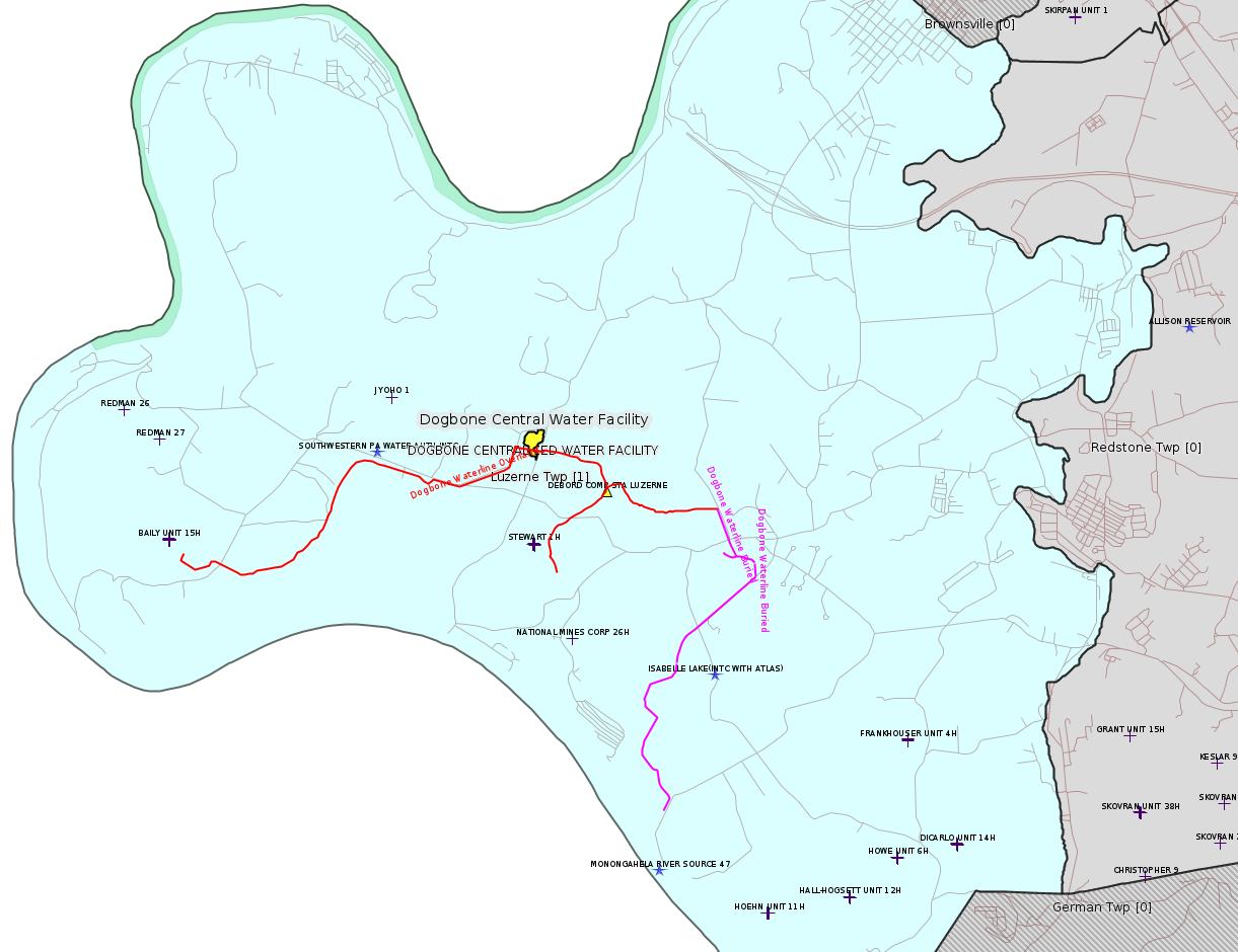
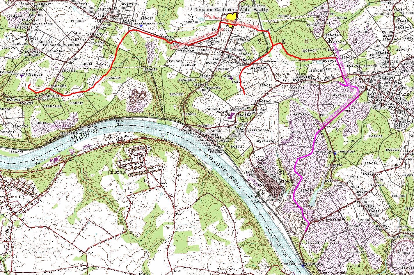
Site: DOGBONE CENTRALIZED WATER FACILITY
Client: CHEVRON APPALACHIA, LLC
Authorization type: RW General Permit Processing Registration
Application type: New
Authorization is for: FACILITY
Date received: 04/25/2017
Status: Pending
Sub-Facility ID Sub-Facility Name Description
1232831 DOGBONE CENTRALIZED WATER FACILITY Processing Facility
Is this authorization type included in Permit Decision Guarantee? : Yes
Permit Decision Guarantee status: VOID
Permit Review Standard Task Information:
Task Start Date Target Date Completion Date
Completeness Review 4/25/2017 n/a 6/7/2017
Technical Review 6/7/2017 8/8/2017
Permit Review Notes:
Date Review Note
6/5/2017 Applicant has been issued a deficiency letter. If applicable, this application no longer qualifies for the Permit Decision Guarantee.
<http://www.ahs.dep.pa.gov/eFACTSWeb/searchResults_singleAuth.aspx?AuthID=1179749>
Location: 39.972496,-79.946939 <http://osm.org/go/ZWpZaULM--?m=>
Municipalities: Luzerne Twp
Presumed Parcel Id: 19160040
Fayette County Act 14 Notification: <http://faymarwatch.org/documents/SKM_554e17050309530.pdf>
[See Notes.]
Authorization ID: 1183070
Permit number: GP08260717002
Site: WELL PLUGGING SITE #592217/592218 (PITTSBURGH NATIONBANK #2 AND #3)
Client: EQT PRODUCTION CO
Authorization type: GP-08 Temporary Road Crossings
Application type: New
Authorization is for: FACILITY
Date received: 05/08/2017
Status: Pending
Sub-Facility ID Sub-Facility Name Description
1234363 WELL PLUGGING SITE PITTSBURGH NATIONAL BANK 2 &3 GP08 Bridge
Permit Review Notes:
Date Review Note
6/6/2017 Applicant has been issued a deficiency letter. If applicable, this application no longer qualifies for the Permit Decision Guarantee.
<http://www.ahs.dep.pa.gov/eFACTSWeb/searchResults_singleAuth.aspx?AuthID=1183070>
Location [Speculative Association] [of MUELLER-HERR 1]: 39.837139,-79.44419
<http://osm.org/go/ZWrEQpgE--?m=>
Location [Speculative Association] [of MUELLER-HERR 604586]: 39.849219,-79.439209
<http://osm.org/go/ZWrEWMcB--?m=>
Municipalities: Stewart Twp
[See Notes.]
Authorization ID: 1185780
Permit number: PAG036123
Site: UNIVERSAL PRESSURE PUMPING MT BRADDOCK FAC
Client: UNIVERSAL PRESSURE PUMPING INC
Authorization type: PAG-03 Discharge of Stormwater Assoc w Industrial Activities
Application type: Transfer
Authorization is for: FACILITY
Date received: 05/31/2017
Status: Pending
Sub-Facilities for Authorization
Sub-Facility ID Sub-Facility Name Description eMap PA Location
1146585 OUTFALL SO1 Discharge Point
1147275 OUTFALL SO2 Discharge Point
<http://www.ahs.dep.pa.gov/eFACTSWeb/searchResults_singleAuth.aspx?AuthID=1185780>
Location 39.94585,-79.655403 <http://osm.org/go/ZWpy31m3--?m=>
Municipalities: North Union Twp
Presumed Parcel Id: 2516000702
[See Notes.]
-------------------------
Source: DEP Oil and Gas Electronic Notifications
NOTIFICATION_ID: 34825
OGO: 39307
OPERATOR: CHEVRON APPALACHIA LLC
API_PERMIT: 051-23958
SPUD_DATE: 05/16/2008
COUNTY: Fayette
MUNICIPALITY: Stewart
LATITUDE: 39.837527
LONGITUDE: -79.54003
SUBJECT: [NOTIFICATION]: Abandonment or plugging notification 58 Pa. C.S. 3211(f)(2) for well API 37-051-23958-00-00
QUESTION: Date and approximate time action is to occur
ANSWER: Date: 5/30/2017 Time: 8:00AM
SENT_DATE: 5/25/2017 10:18:35 AM
SENT_SUCCESS: Yes
LAST_RESENT_DATE:
RESENT_SUCCESS:
Comments: this is an amended notification from the original submition on 5/18/2017 at 12:31PM (original start was for 5/22/2017)
Farm Name: AVANTI 1
Location: 39.837527,-79.54003 <http://osm.org/go/ZWpuQBy2--?m=>
Presumed Parcel Id: 37150002
SPUD Date: 5/16/2008
Well Status: Regulatory Inactive Status
Conservation Well: Y
Well Configuration: Vertical Well
Coal: Coal
WELL PAD ID: 146849
Most Recent Production Period: *Never*
-------------------------
Source: Reuters Commodities: Energy
Natural Gas
| Commodity | Exchange | Currency | Expire | Last Trade | Trade Time | Change | Open | Day's High | Day's Low |
|---|---|---|---|---|---|---|---|---|---|
| NATURAL
GAS CON1 Jun17 |
NYM | USD | 06/28 | 3.02 | 06/11 22:41 | -0.00 | 3.01 | 3.02 | 3.01 |
-------------------------
Notes:
Chevron's maps for the DOGBONE CENTRALIZED WATER FACILITY and the DOG BONE WATERLINE (supplied to Fayette County with Act 14 Notifications) show the waterline clearly intersecting the boundaries of the Centralized Water Facility. Accordingly, the two projects are being mapped here together as one project, which is how this should be considered. The red portion of the waterline is described by Chevron as overland, the purple is described as buried. The Centralized Water Facility is shown in yellow with a black outline. The maps were created by overlaying the geotiff file for the Carmichaels Quad USGS topographic map with "GIS-warped" tiffs constructed from scanning Chevron's Act 14 maps, then tracing the pipeline in GIS software.
This facility raises many disturbing questions. The Dogbone Centralized Water Facility is being permitted for "Residual Waste". It cannot be a coincidence that the Dog Bone Waterline intersects this facility, and one assumes the waterline will be connected to the tank farm in the Centralized Water Facility. That means: the pipeline will be acting as a residual waste reuse pipeline. Did all those granting easements for this "waterline" properly understand that it was to function as a residual waste line? What direction will "water" flow through the various segments of this pipeline? Will DEP in fact evaluate these two projects together as a single project? What exactly will be happening at the southeast end of this project? (At its southeast end, Chevron shows the pipeline connecting to an existing pipeline called "4-H (Young)"). (The 4-H (Young) pipeline is not currently integrated into the mapping.) Does this pipeline connect to the "Water Management Plan" known as "Monongahela River Source 47"? It sure looks that way. If so, this would provide a potential hydrological pathway from the Centralized Water Facility directly into the Monongahela River, and discharge into the Mon from the tank farm is surely illegal. What provision will there be to monitor that this is not happening? We have word from the Fayette County Office of Planning, Zoning, and Community Development that the Centralized Water Facility will require a Special Exception as a Public/Private Works. This will require a public hearing, at which these and other questions can be raised.
---
Authorization 1183070 above for EQT has very confusing metadata. The exact authorization is for a road crossing, and lists two wells, PITTSBURGH NATIONBANK #2 AND #3. There aren't wells with those names. It also shows two site numbers, which also appear to be wrong. The municipality shows as Stewart Twp, and there only seem to be two EQT wells in Stewart Twp, which are called in DEP's Oil & Gas Mapping database as MUELLER-HERR 1 and MUELLER-HERR 604586, so those are the two locations that are mapped.
---
According to their web site, "Universal Pressure Pumping, Inc. and Universal Well Services, Inc. are subsidiaries of Patterson-UTI Energy, Inc."
------------------------
DEP defines an environmental justice area as "any census tract where 20 percent or more individuals live in poverty, and/or 30 percent or more of the population is minority". (See:
<http://www.dep.pa.gov/PublicParticipation/OfficeofEnvironmentalJustice/Pages/default.aspx>). There are supposed to be enhanced public participation requirements for permits in environmental justice areas, but news of this actually ever happening is scarce. In Fayette County, the entirety of Springhill, Nicholson, German, and Georges Townships are environmental justice areas, as well as a large part of Dunbar Township. DEP's policy document on public participation guidelines for environmental justice areas is located here:
<http://www.elibrary.dep.state.pa.us/dsweb/Get/Version-48671/012-0501-002.pdf>
eNOTICE records are likely to list the same permit multiple times, as that permit moves through the DEP process.
Oil & Gas Wells designated with a site a number and the letter H typically designate horizontal wells.
-------------------------
Resources:
Pennsylvania Bulletin: <http://www.pabulletin.com/>
eNOTICE: <http://www.ahs2.dep.state.pa.
DEP Oil and Gas Reports: <http://www.dep.pa.gov/DataandTools/Reports/Oil%20and%20Gas%20Reports/Pages/default.aspx>
DEP Well Details Report: <https://www.paoilandgasreport
Well Details may not show any
information for new permits and will not show permits which have
not yet been issued. Lookup for Well Details is by permit number.
DEP Permits Issued Detail Report:
<http://www.depreportingservic
DEP SPUD (drilling started) Report:
<http://www.depreportingservices.state.pa.us/ReportServer/Pages/ReportViewer.aspx?/Oil_Gas/Spud_External_Data>
DEP Oil and Gas Compliance Report:
<http://www.depreportingservices.state.pa.us/ReportServer/Pages/ReportViewer.aspx?/Oil_Gas/OG_Compliance>
DEP PA Oil & Gas Mapping:
<http://www.depgis.state.pa.us/PaOilAndGasMapping>
DEP Oil and Gas Electronic Notifications
<http://www.depreportingservices.state.pa.us/ReportServer?/Oil_Gas/OG_Notifications>
DEP Oil and Gas Well Pad Report
<http://www.depreportingservices.state.pa.us/ReportServer?/Oil_Gas/Well_Pads>
Fayette County Assessment Office Search For Tax Records:
<http://property.co.fayette.pa.us/search.aspx>
Pennsylvania Spatial Data Access:
<http://www.pasda.psu.edu/default.asp>
DEP Spatial Data Repository:
<ftp://www.pasda.psu.edu/pub/pasda/dep/>
National Response Center:
<http://www.nrc.uscg.mil/>
EPA-Echo: <http://www.epa-echo.gov/echo/
FERC citizen involvement: <http://www.ferc.gov/for-citiz
To receive E-mail notification of
all documents filed in a FERC docket, see:
<http://www.ferc.gov/docs-filing/esubscription.asp >
<http://www.ferc.gov/docs-fili
Follow the directions and enter the docket number to subscribe to.
Township Supervisors receive information regarding Erosion & Sedimentation permits, and these records may be reviewable at township municipal offices.
DEP permits are reviewable through the File Review process, for application to do file review see: <http://www.portal.state.pa.us/portal/server.pt/community/southwest_regional_office/13775/file_review/593164>
Environmental Hearing Board: <http://ehb.courtapps.com/publ
PA DEP Environmental Policy Comment System:
<http://www.ahs.dep.pa.gov/eComment/>
Federal Register Environment: <https://www.federalregister.g
Browsing of recent comment
opportunities for federal agencies, e.g. EPA. Click "sign up" to
subscribe to daily E-mails of new document listings.
SkyTruth Fayette County Drilling Alerts: <http://frack.skytruth.org/pen
U.S. Army Corps of Engineers, Pittsburgh District, Public Notices:
<http://www.lrp.usace.army.mil/Missions/Regulatory/Public-Notices/>
EPA Pennsylvania Public Notices: <http://www2.epa.gov/aboutepa/epa-pennsylvania#notice>
Marcellus Shale waste disposal
injection wells in Pennsylvania are regulated directly by EPA, not
DEP. Notice of any new permit applications will appear at the
above web address. I'm not aware of any subscription service
to be notified of such applications. I'm not aware of any
Marcellus Shale waste disposal injection wells in Fayette County
(yet ...) but we need to monitor this page for future
applications.
Energy Assurance Daily: <http://www.oe.netl.doe.gov/ead.aspx>
Daily newsletter from the US
Department of Energy about events relating to energy. The Natural
Gas section has information about pipelines.
-------------------------
Disclaimers:
This compilation from the above sources was done by hand using copy and paste and may omit relevant permits.
Parcel data is provided via the tax records search web page offered by the Fayette County Assessment Office (http://property.co.fayette.pa.us/). Presumed Parcel Id links are subject to availability provided by that agency and associated web sites. Presumed Parcel Ids are determined as the mapped parcel containing a given latitude and longitude, are a best effort determination which is subject to error, and are not official. In cases where a facility is leased and there is a separate parcel id for the lease, if this parcel id is not separately mapped, the parcel id shown will be the id for the enclosing parcel. Parcel owners may be surface owners only and may or may not have any relationship to oil & gas facilities.
Does not currently include water supply permits. Does not include landfill permits even though many such are for Marcellus Shale waste. (It is not possible at this time to distinguish which landfill permits are for Marcellus Shale waste and which are not without doing File Review for each permit.)
Erosion & Sedimentation permit records do not currently include latitude and longitude. Where I am publishing latitude and longitude with E&S permits it is by inferring an associated well permit and using published latitude and longitude for the well. It is possible I may be inferring the wrong well site.
Municipalities are shown from eFACTS records on the DEP web site. The DEP has been known to list a municipality incorrectly.