The Harmed Success Stories Concepts How To What Is Commentary
Fayette County Marcellus Shale Permits 5/30/16 - 6/12/16
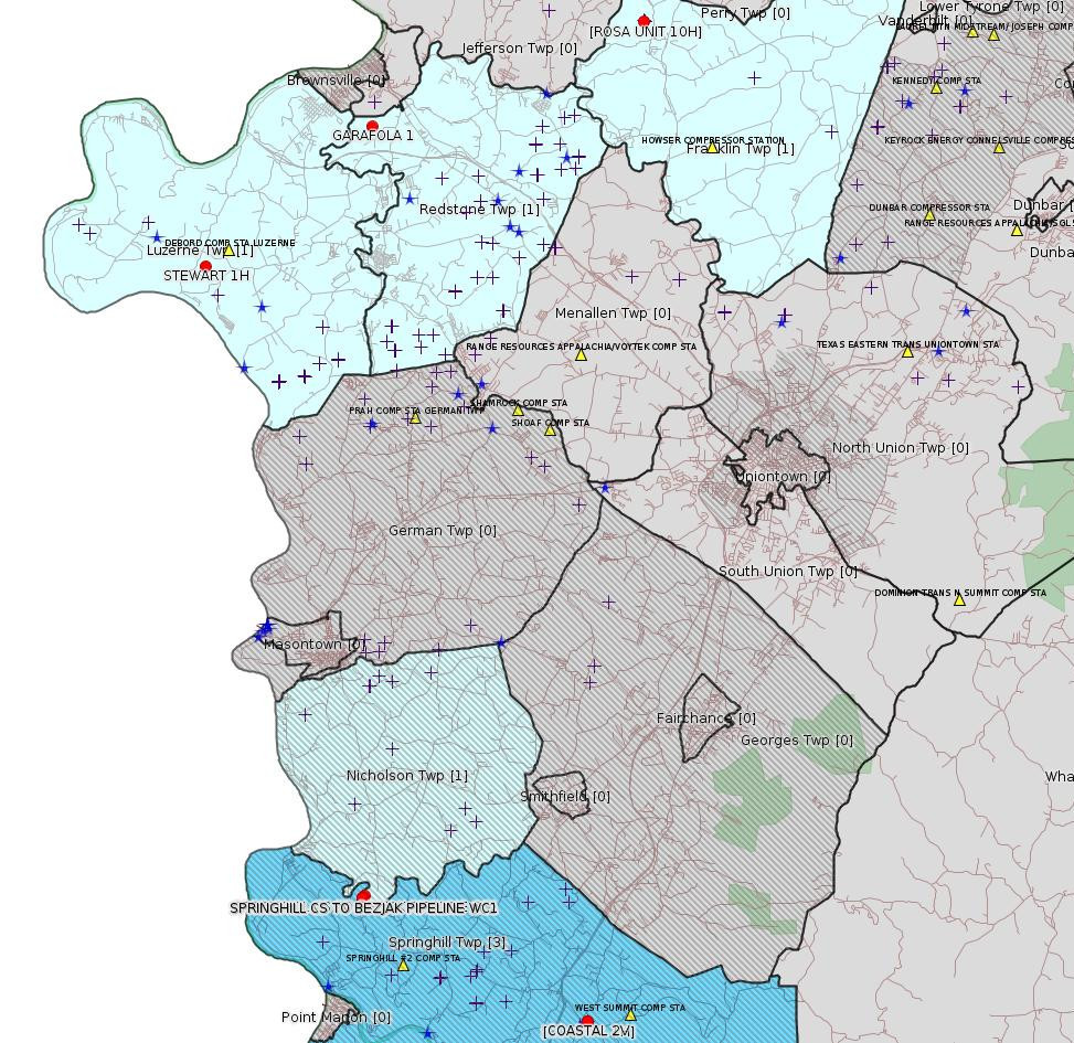
Click the map to enlarge
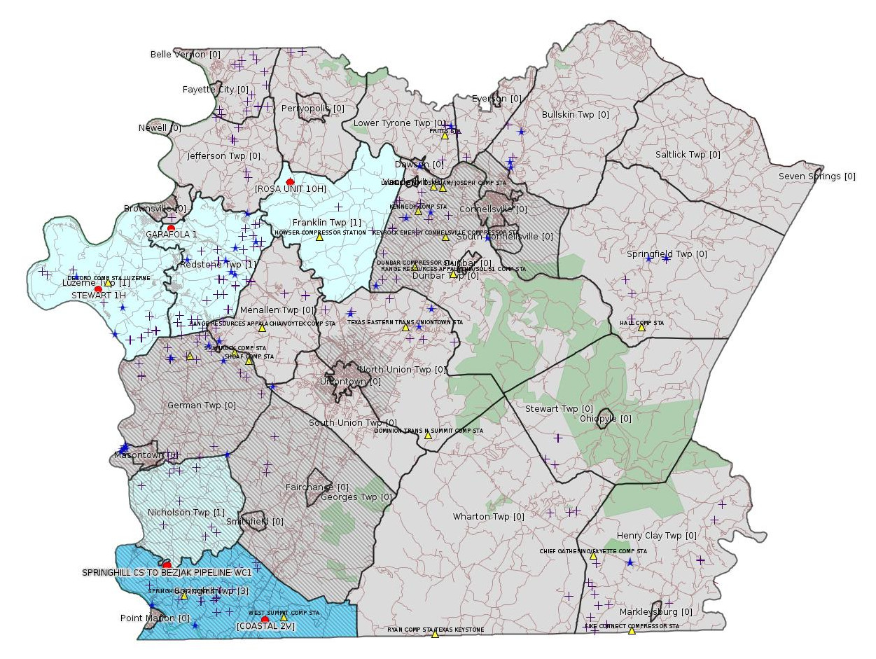
Map
Key
Red dots: items in this permit list with an exact location.
Blue stars: Marcellus Gas Well Water Sources.
Municipality shading: number of "facilities", with each well counting separately
(includes the red dots):
Red dots: items in this permit list with an exact location.
Blue stars: Marcellus Gas Well Water Sources.
Municipality shading: number of "facilities", with each well counting separately
(includes the red dots):
gray: 0
pale turquoise: 1
turquoise: 2
pale blue: 3
middle blue: 4
dark blue: 6
dark purple: 11
purple: 19
(Color coding may differ from one issue to the next.)
(Note if a project spans multiple municipalities -- e.g. a pipeline -- it will show in the count for each municipality.)
The number of facilities also follows the municipality name in brackets.
Municipality counts are based on the way the permit is listed by DEP; DEP has been known to get a municipality wrong.
Locations in brackets identify a precise location used to locate a surrogate for the actual site being permitted (e.g. locating a well pad or pipeline by the known location of a well.) Locations labeled beginning with "~" and ending in "[?]" are approximate and speculative based on inferences using on-line property and lease records. These are marked in the text as "[Approximate, Speculative]
Cross-hatching: Environmental Justice Areas
Yellow triangles: Compressor Stations
Crosses: Unconventional well permits (may not have been drilled)
Green: "Natural areas", e.g. state game lands, state forests
Yellow triangles: Compressor Stations
Crosses: Unconventional well permits (may not have been drilled)
Green: "Natural areas", e.g. state game lands, state forests
More Maps
 |
 |
Source: Pennsylvania Bulletin
[No Activity.]
-------------------------
Source: eNOTICE (+ PA Oil and Gas Mapping) Please see the Disclaimer below regarding Parcel Id data.
Authorization ID: 1134271
Permit number: 051-21230
Site: GARAFOLA 1 OG WELL
Client: KEYROCK ENERGY LLC
Authorization type: Well Plugging Notice Intent to Plug Single Well
Application type: New
Authorization is for: FACILITY
Date received: 04/15/2016
Status: Withdrawn on 5/25/2016
Sub-Facility ID Sub-Facility Name Description
533284 GARAFOLA 1 Well
Permit Review Notes [Excerpt]:
Date Review Note
5/11/2016 Applicant has been issued a deficiency letter. If applicable, this application no longer qualifies for the Permit Decision Guarantee.
<http://www.ahs.dep.pa.gov/eFACTSWeb/searchResults_singleAuth.aspx?AuthID=1134271>
Location: 40.004581,-79.880819 <http://osm.org/go/ZWpeGQ1h--?m=>
Municipalities: Redstone Twp
Presumed Parcel Id: 30040220
Authorization ID: 1110466
Permit number: GP05260716001
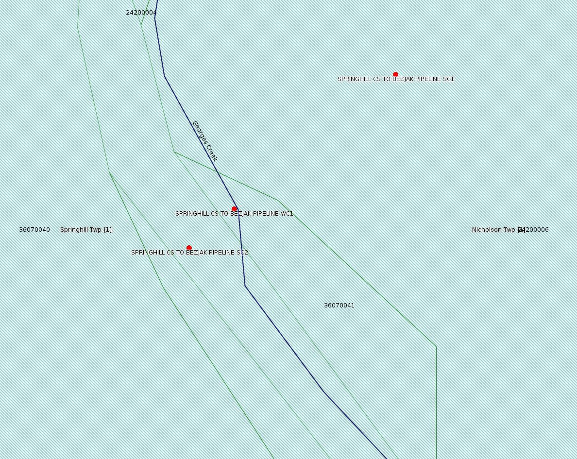
Site: SPRINGHILL CS TO BEZJAK PIPELINE GP05260716001
Client: LAUREL MTN MIDSTREAM OPR LLC
Authorization type: GP-05 Utility Line Stream Crossings
Application type: New
Authorization is for: FACILITY
Date received: 02/16/2016
Status: Issued on 5/26/2016
Sub-Facility ID Sub-Facility Name Description
1207288 STREAM CROSSING 1 Pipeline or Conduit
1212794 STREAM CROSSING 2 Pipeline or Conduit
1212792 WETLAND CROSSING 1 Pipeline or Conduit
<http://www.ahs.dep.pa.gov/eFACTSWeb/searchResults_singleAuth.aspx?AuthID=1110466>
Location [SC1]: 39.772040,-79.887572 <http://osm.org/go/ZWpLAOjW--?m=>
Location [SC2]: 39.771383,-79.888614 <http://osm.org/go/ZWpLAJr~--?m=>
Location [WC1]: 39.771531,-79.888386 <http://osm.org/go/ZWpLALD~--?m=>
Municipalities: Nicholson Twp [an Environmental Justice Area], Springhill Twp [an Environmental Justice Area]
Presumed Parcel Ids: 36070040, 36070041, 24200006
[See Notes.]
Authorization ID: 1136282
Permit number: 051-24621
Site: STEWART WELL SITE ESCGP-2 EXPEDITED
Client: CHEVRON APPALACHIA LLC
Authorization type: Drill & Operate Well Permit Drill Deeper
Application type: New
Authorization is for: FACILITY
Date received: 04/29/2016
Status: Issued on 5/26/2016
Sub-Facility ID Sub-Facility Name Description
1211522 STEWART 1H Well
<http://www.ahs.dep.pa.gov/eFACTSWeb/searchResults_singleAuth.aspx?AuthID=1136282>
Location: 39.962961,-79.946955 <http://osm.org/go/ZWpZPAL7--?m=>
Municipalities: Luzerne Twp
Presumed Parcel Id: 19250010
Conservation Well: N
SPUD Date: 9/2/2015
Original (Drill & Operate Well) Full Permit:
<http://www.depgis.state.pa.us/PaOilAndGasMapping/PdFFetcher.ashx?Doc=FXcU5e%2fISP%2f087MkEb%2fo7A%3d%3d&ext=PDF>
Full (Drill & Operate Well Permit Drill Deeper) Permit:
<http://www.depgis.state.pa.us/PaOilAndGasMapping/PdFFetcher.ashx?Doc=YhC8xvohvJdOtEdJOcNyOg%3d%3d&ext=PDF>
[See Notes.]
Authorization ID: 1096925
Permit number: ESX15-051-0012
Site: COASTAL CENTRAL WELL PAD ESCGP-2 EXPEDITED
Client: BURNETT OIL CO INC
Authorization type: Expedited E&S Stormwater General Permit 1
Application type: New
Authorization is for: SITE
Date received: 11/12/2015
Status: Pending
Permit Review Notes:
Date Review Note
5/31/2016 Applicant has been issued a deficiency letter. If applicable, this application no longer qualifies for the Permit Decision Guarantee.
5/23/2016 Applicant has been issued a deficiency letter. If applicable, this application no longer qualifies for the Permit Decision Guarantee.
<http://www.ahs.dep.pa.gov/eFACTSWeb/searchResults_singleAuth.aspx?AuthID=1096925>
Location [approximate, speculative] [of COASTAL 1H]: 39.733294,-79.801028 <http://osm.org/go/ZWpgBJ2N--?m=>
Municipalities: Springhill Twp [an Environmental Justice Area]
Presumed Parcel Id: 36210048
Authorization ID: 1107547
Permit number: ESX11-051-0038
Site: ROSA WELL MCLS NO 1511 ESCGP-EXPEDITED
Client: CHEVRON APPALACHIA LLC
Authorization type: Expedited E&S Stormwater General Permit 1
Application type: Amendment
Authorization is for: SITE
Date received: 02/10/2016
Status: Pending
Permit Review Notes:
Date Review Note
6/1/2016 Applicant has been issued a deficiency letter. If applicable, this application no longer qualifies for the Permit Decision Guarantee.
<http://www.ahs.dep.pa.gov/eFACTSWeb/searchResults_singleAuth.aspx?AuthID=1107547>
Location [of ROSA UNIT 10H (surrogate)]: 40.035347,-79.773372 <http://osm.org/go/ZWp1Ip5a--?m=>
Municipalities, Franklin Twp
Presumed Parcel Id: 13040083
[See Notes.]
Authorization ID: 1107917
Permit number: 051-24636
Site: COASTAL 1H FLOW BACK PIT FRESHWATER PITS ESCGP-EXPEDITED
Client: BURNETT OIL CO INC
Authorization type: Drill & Operate Well Permit
Application type: New
Authorization is for: FACILITY
Date received: 02/10/2016
Status: Pending
Sub-Facility ID Sub-Facility Name Description
1205967 COASTAL 2V Well
<http://www.ahs.dep.pa.gov/eFACTSWeb/searchResults_singleAuth.aspx?AuthID=1107917>
Location: 39.733336,-79.800886
Municipalities: Springhill Twp [an Environmental Justice Area]
Conservation Well: Y
Unconventional Well: N
Presumed Parcel Id: 36210048
-------------------------
Source: Reuters Commodities: Energy
Natural Gas
| Commodity | Exchange | Currency | Expire | Last Trade | Trade Time | Change | Open | Day's High | Day's Low |
|---|---|---|---|---|---|---|---|---|---|
| NATURAL
GAS CON1 Jun16 |
NYM | USD | 06/28 | 2.58 | 06/11 21:42 | +0.03 | 2.60 | 2.61 | 2.58 |
-------------------------
Notes:
There is actually no such thing as a "pipeline permit" for gathering lines in Pennsylvania. An Erosion & Sedimentation permit is required for earth disturbance of 5 acres or greater; stream crossings, road crossings, etc. require specific permits. Latitude and longitude information provided by DEP for these specific permits do not map the full extent of the pipeline.
The owner for parcel 36070040 conerning the SPRINGHILL CS TO BEZJAK PIPELINE GP05260716001 reports that this pipeline is already long since in the ground, and the permit being applied for is seriously retroactive. (Note: The correct name of the road shown on OpenStreetMap as "Cagy Road" is actually Volek Road.)
---
Permit applications of type "Drill & Operate Well Permit Drill Deeper" call for special scrutiny. Despite the apparent meaning of "Drill Deeper", we have seen in many cases that what these applications really mean is that the well is being done over. Close examination of all inspection reports for the well pad in question often reveals an anomaly of one kind or another; among the issues that have shown up just in Fayette County are cement problems, horizontal failed due to an unanticipated geological fault, and an unacknowledged underground explosion. (Such anomalies are typically only shown in the comment field of inspection reports, and are not written up as violations for the actual anomaly in question. In fact usually there is no violation at all.) In the case of authorization 1136282 above, while we don't seem to have an anomaly for Stewart 1H, there is an anomaly for Stewart 2H, i.e. a cementing problem. The 11/1/15 issue of this bulletin shows the following entry from the DEP Oil & Gas Compliance Report:
OPERATOR: CHEVRON APPALACHIA LLC
INSPECTION_ID: 2419580
INSPECTION_DATE: 10/23/2015
INSPECTION_TYPE: Drilling/Alteration
API_PERMIT: 051-24628
FARM_NAME: STEWART 2H
UNCONVENTIONAL: Y
SITE_ID: 788124
SITE_NAME: STEWART WELL SITE ESCGP-2 EXPEDITED
FACILITY_TYPE: Oil & Gas Location
INSPECTION_CATEGORY: Primary Facility
REGION: EP DOGO SWDO Dstr Off
COUNTY: Fayette
MUNICIPALITY: Luzerne Twp
INSPECTION_RESULT_DESCRIPTION: No Violations Noted
INSPECTION_COMMENT: HORIZONTAL MARCELLUS, Drilling on air @ 3197' (TD). Setting Intermediate Casing and cementing tonight (10/23/2015). During cementing of casing loss circulation occurred at end of job. Operator has agree to (CBL) to determine top of cement.
"CBL" stands for Cement Bonding Log. It is a kind of down-hole sonogram that can reveal flaws in the cement job.
---
The Site Permit for the Rosa Well pad for permit # ESX11-051-0038 above was originally issued on 1/10/2012.
------------------------
DEP defines an environmental justice area as "any census tract where 20 percent or more individuals live in poverty, and/or 30 percent or more of the population is minority". (See:
<http://www.portal.state.pa.us/portal/server.pt/community/pa_environmental_justice_areas/20991>
<http://www.portal.state.pa.us/portal/server.pt/community/dep_enhanced_public_participation_policy/20988>
). There are supposed to be enhanced public participation requirements for permits in environmental justice areas, but news of this actually ever happening is scarce. In Fayette County, the entirety of Springhill, Nicholson, German, and Georges Townships are environmental justice areas, as well as a large part of Dunbar Township. DEP's policy document on public participation guidelines for environmental justice areas is located here:
<http://www.elibrary.dep.state.pa.us/dsweb/Get/Version-48671/012-0501-002.pdf>
eNOTICE records are likely to list the same permit multiple times, as that permit moves through the DEP process.
Oil & Gas Wells designated with a site a number and the letter H typically designate horizontal wells.
-------------------------
Resources:
Pennsylvania Bulletin: <http://www.pabulletin.com/>
eNOTICE: <http://www.ahs2.dep.state.pa.
DEP Well Details Report: <https://www.paoilandgasreport
Well Details may not show any
information for new permits and will not show permits which have
not yet been issued. Lookup for Well Details is by permit number.
DEP Permits Issued Detail Report:
<http://www.depreportingservic
DEP SPUD (drilling started) Report:
<http://www.depreportingservices.state.pa.us/ReportServer/Pages/ReportViewer.aspx?/Oil_Gas/Spud_External_Data>
DEP Oil and Gas Compliance Report:
<http://www.depreportingservices.state.pa.us/ReportServer/Pages/ReportViewer.aspx?/Oil_Gas/OG_Compliance>
DEP PA Oil & Gas Mapping:
<http://www.depgis.state.pa.us/PaOilAndGasMapping>
Fayette County Assessment Office Search For Tax Records:
<http://property.co.fayette.pa.us/search.aspx>
Pennsylvania Spatial Data Access:
<http://www.pasda.psu.edu/default.asp>
DEP Spatial Data Repository:
<ftp://www.pasda.psu.edu/pub/pasda/dep/>
National Response Center:
<http://www.nrc.uscg.mil/>
EPA-Echo: <http://www.epa-echo.gov/echo/
FERC citizen involvement: <http://www.ferc.gov/for-citiz
To receive E-mail notification of
all documents filed in a FERC docket, see:
<http://www.ferc.gov/docs-filing/esubscription.asp >
<http://www.ferc.gov/docs-fili
Follow the directions and enter the docket number to subscribe to.
Township Supervisors receive information regarding Erosion & Sedimentation permits, and these records may be reviewable at township municipal offices.
DEP permits are reviewable through the File Review process, for application to do file review see: <http://www.portal.state.pa.us/portal/server.pt/community/southwest_regional_office/13775/file_review/593164>
Environmental Hearing Board: <http://ehb.courtapps.com/publ
PA DEP Environmental Policy Comment System:
<http://www.ahs.dep.pa.gov/eComment/>
Federal Register Environment: <https://www.federalregister.g
Browsing of recent comment
opportunities for federal agencies, e.g. EPA. Click "sign up" to
subscribe to daily E-mails of new document listings.
SkyTruth Fayette County Drilling Alerts: <http://frack.skytruth.org/pen
EPA Pennsylvania Public Notices: <http://www2.epa.gov/aboutepa/epa-pennsylvania#notice>
Marcellus Shale waste disposal
injection wells in Pennsylvania are regulated directly by EPA, not
DEP. Notice of any new permit applications will appear at the
above web address. I'm not aware of any subscription service
to be notified of such applications. I'm not aware of any
Marcellus Shale waste disposal injection wells in Fayette County
(yet ...) but we need to monitor this page for future
applications.
Energy Assurance Daily: <http://www.oe.netl.doe.gov/ead.aspx>
Daily newsletter from the US
Department of Energy about events relating to energy. The Natural
Gas section has information about pipelines.
-------------------------
Disclaimers:
This compilation from the above sources was done by hand using copy and paste and may omit relevant permits.
Parcel data is provided via the tax records search web page offered by the Fayette County Assessment Office (http://property.co.fayette.pa.us/). Presumed Parcel Id links are subject to availability provided by that agency and associated web sites. Presumed Parcel Ids are determined as the mapped parcel containing a given latitude and longitude, are a best effort determination which is subject to error, and are not official. In cases where a facility is leased and there is a separate parcel id for the lease, if this parcel id is not separately mapped, the parcel id shown will be the id for the enclosing parcel. Parcel owners may be surface owners only and may or may not have any relationship to oil & gas facilities.
Does not currently include water supply permits. Does not include landfill permits even though many such are for Marcellus Shale waste. (It is not possible at this time to distinguish which landfill permits are for Marcellus Shale waste and which are not without doing File Review for each permit.)
Erosion & Sedimentation permit records do not currently include latitude and longitude. Where I am publishing latitude and longitude with E&S permits it is by inferring an associated well permit and using published latitude and longitude for the well. It is possible I may be inferring the wrong well site.
Municipalities are shown from eFACTS records on the DEP web site. The DEP has been known to list a municipality incorrectly.