The Harmed Success Stories Concepts How To What Is Commentary
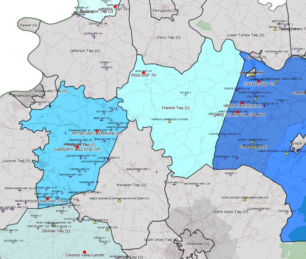
Fayette County Marcellus Shale Permits 6/16/14 - 6/29/14
Click the map to enlarge
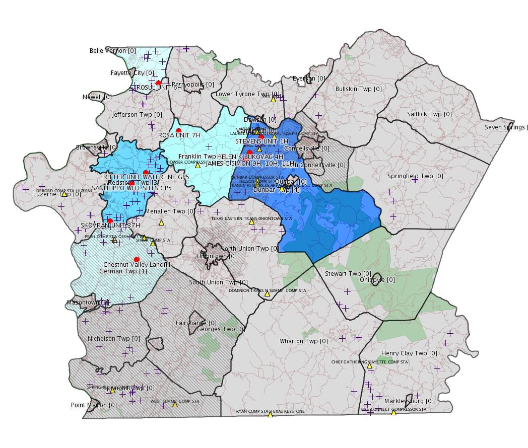
Map
Key
Red dots: items in this permit list with an exact location.
Municipality shading: number of "facilities", with each well counting separately
(includes the red dots):
Red dots: items in this permit list with an exact location.
Municipality shading: number of "facilities", with each well counting separately
(includes the red dots):
gray: 0
pale turquoise: 1
turquoise: 2
pale blue: 3
middle blue: 4
dark blue: 6
purple: 7
(Color coding may differ from one issue to the next.)
(Note if a project spans multiple municipalities -- e.g. a pipeline -- it will show in the count for each municipality.)
The number of facilities also follows the municipality name in brackets.
Municipality counts are based on the way the permit is listed by DEP; DEP has been known to get a municipality wrong.
Locations labeled beginning with "~" and ending in "[?]" are approximate and speculative based on inferences using on-line property and lease records. These are marked in the text as "[Approximate, Speculative]
eFACTS/eNOTICE applications of type Notification are not mapped.
Cross-hatching: Environmental
Justice
Areas
Yellow triangles: Compressor Stations
Crosses: Unconventional well permits (may not have been drilled)
Green: "Natural areas", e.g. state game lands, state forests
Yellow triangles: Compressor Stations
Crosses: Unconventional well permits (may not have been drilled)
Green: "Natural areas", e.g. state game lands, state forests
More Maps
 |
Source: Pennsylvania Bulletin
[Greene County]
NOTICES
DEPARTMENT OF CONSERVATION AND NATURAL RESOURCES
Execution of Oil and Gas Lease for Publicly-Owned Streambeds
[44 Pa.B. 3969]
[Saturday, June 28, 2014]
Effective March 12, 2014, an Oil and Gas Lease for Publicly-Owned Streambeds, Contract No. M-2102009-04, was executed by and between the Commonwealth, acting through the Department of Conservation and Natural Resources (Department) (lessor), and Chevron Appalachia, LLC (lessee), with its principal place of business located at 1550 Coraopolis Heights Road, 2nd Floor, P. O. Box 611, Moon Township, PA 15108.
The lease is for Streambed Tract 2009 and includes two separate parcels encompassing a total of approximately 57 acres of submerged lands located in Dunkard, Gilmore and Perry Townships, Greene County. The lease was recorded at the Greene County courthouse on April 23, 2014, instrument no. 201400002268, Book 467, pages 3450—3479. The lease allows for the development of oil and natural gas below and between the ordinary low water marks of Dunkard Creek solely by means of directional, including horizontal, drilling on a nondevelopment basis that will not disturb the river or its bed. Contract No. M-2102009-04 may be viewed online at http://contracts.patreasury.gov/View.aspx?ContractID=265416.
Questions regarding this lease should be directed to the Department's Bureau of Forestry, Minerals Division at (717) 787-2703.
ELLEN M. FERRETTI,
Secretary
<http://www.pabulletin.com/secure/data/vol44/44-26/1347.html>
---
Southwest Region: Environmental Cleanup & Brown- field Development Program Manager, 400 Waterfront Drive, Pittsburgh, Pa 15222-4745
Helen Bukovac #4 Well Site, 760 Little Summit Road Extension, Dunbar Township, Fayette County. Groundwater & Environmental Services, Inc., 301 Commerce Park Drive, Cranberry Township, PA 16066 on behalf of XTO Energy Inc., 395 Airport Road, Indiana, PA 15701 has submitted a Notice of Intent to Remediate (NIR) to meet a combination of residential Statewide Health and Site Specific Standards concerning site soils contaminated with aluminum, antimony, arsenic, barium, beryllium boron, cadmium chromium, cobalt, copper, iron lead, manganese, mercury, nickel, selenium, silver, thallium, vanadium, zinc and chloride. The NIR indicated future use of the property is to remain a natural gas production well. This notice was published in the Daily Courier on June 3, 2014.
<http://www.pabulletin.com/secure/data/vol44/44-26/1348c.html>
Site: HELEN BUKOVAC #4 WELL SITE
Site ID: 783992
Location [of HELEN K BUKOVAC 4H] 40.010133,-79.672622 <http://osm.org/go/ZWp2lQXc--?m=>
[For the inspection reports related to this case, see below.]
---
26-00599A: PPL Renewable Energy, LLC (Two North Ninth Street, Allentown, PA 18101) on June 10, 2014, to install and initial temporary operation of a landfill gas to energy plant at the Chestnut Valley Landfill in German Township, Fayette County. Sources include landfill gas treatment system, two (2) landfill gas-fired reciprocating internal combustion engines, and associated two (2) electric generators.
<http://www.pabulletin.com/secure/data/vol44/44-26/1348c.html>
Location: 39.894544,-79.836022 <http://osm.org/go/ZWpP2SSr--?m=>
Municipalities: German Twp [an Environmental Justice Area]
-------------------------
Source: eNOTICE
Authorization ID: 1024001
Permit number: GP05260714001
Site: SANFILIPPO WELL SITES GP5
Client: CHEVRON APPALACHIA LLC
Authorization type: GP-05 Utility Line Stream Crossings
Application type: New
Authorization is for: FACILITY
Date received: 04/29/2014
Status: Issued on 6/13/2014
Sub-Facility ID Sub-Facility Name Description
1133953 STREAM CROSSING #1 Pipeline or Conduit
1137201 STREAM CROSSING #2 Pipeline or Conduit
<http://www.ahs.dep.pa.gov/eFACTSWeb/searchResults_singleAuth.aspx?AuthID=1024001>
Location: 39.977619,-79.841939 <http://osm.org/go/ZWpbxxzu--?m=>
Municipalities: Redstone Twp
Authorization ID: 1027380
Permit number: ESX10-051-0045
Site: STEVENS UNIT 1H, 2H ESCGP-EXPEDITED
Client: PHILLIPS EXPLORATION INC
Authorization type: Expedited E&S Stormwater General Permit 1
Application type: Amendment
Authorization is for: SITE
Date received: 05/21/2014
Status: Pending
<http://www.ahs.dep.pa.gov/eFACTSWeb/searchResults_singleAuth.aspx?AuthID=1027380>
Location [of STEVENS UNIT 1H]: 40.027158,-79.655672 <http://osm.org/go/ZWp22x0B--?m=>
Municipalities: Dunbar Boro [should be Dunbar Twp -jr]
Authorization ID: 1029680
Permit number: GP05260714003
Site: RITTER UNIT WATERLINE GP5
Client: CHEVRON APPALACHIA LLC
Authorization type: GP-05 Utility Line Stream Crossings
Application type: New
Authorization is for: FACILITY
Date received: 06/11/2014
Status: Pending
Sub-Facility ID Sub-Facility Name Description
1137231 UNT TO ROWES RUN Pipeline or Conduit
<http://www.ahs.dep.pa.gov/eFACTSWeb/searchResults_singleAuth.aspx?AuthID=1029680>
Location: 39.989992,-79.821656 <http://osm.org/go/ZWpb9fzv--?m=>
Municipalities: Redstone Twp
Authorization ID: 1030792
Permit number: GP5-26-00544B
Site: KEYROCK ENERGY CONNELSVILLE COMPRESSOR STA
Client: KEYROCK ENERGY LLC
Authorization type: AQ General Permit
Application type: Renewal
Authorization is for: FACILITY
Date received: 06/19/2014
Status: Pending
<http://www.ahs.dep.pa.gov/eFACTSWeb/searchResults_singleAuth.aspx?AuthID=1030792>
Municipalities: Dunbar Twp
[See Notes.]
Authorization ID: 1027602
Permit number: ESX14-051-0005
Site: JAMES G SIMON 9H, 10H, 11H OG WELL ESCGP-2 EXPEDITED
Client: XTO ENERGY INC
Authorization type: Expedited E&S Stormwater General Permit 1
Application type: New
Authorization is for: SITE
Date received: 05/21/2014
Status: Pending
<http://www.ahs.dep.pa.gov/eFACTSWeb/searchResults_singleAuth.aspx?AuthID=1027602>
Location [Approximate]: 40.003409,-79.677633 <http://osm.org/go/ZWp2OlhH--?m=>
Municipalities: Dunbar Twp
Authorization ID: 1015422
Permit number: ESX10-051-0051
Site: SKOVRAN #37-40H WELL SITE ESCGP-EXPEDITED
Client: CHEVRON APPALACHIA LLC
Authorization type: Expedited E&S Stormwater General Permit 1
Application type: Amendment
Authorization is for: SITE
Date received: 02/26/2014
Status: Pending
<http://www.ahs.dep.pa.gov/eFACTSWeb/searchResults_singleAuth.aspx?AuthID=1015422>
Location [of SKOVRAN UNIT 37H]: 39.937003,-79.873311 <http://osm.org/go/ZWpaWsFW--?m=>
Municipalities: Redstone Twp
Authorization ID: 1028362
Permit number: ESX14-051-0007
Site: MAWC 7020 ESCGP-2 EXPEDITED
Client: TRIANA ENERGY LLC
Authorization type: Expedited E&S Stormwater General Permit 1
Application type: New
Authorization is for: SITE
Date received: 06/02/2014
Status: Pending
<http://www.ahs.dep.pa.gov/eFACTSWeb/searchResults_singleAuth.aspx?AuthID=1028362>
Location [of MAWC 7020 3H]: 39.977814,-79.437242 <http://osm.org/go/ZWrRTb1P--?m=>
Municipalities: Springfield Twp
[See Notes.]
Authorization ID: 1031735
Permit number: 051-24520
Site: ROSA WELL MCLS NO 1511 ESCGP-EXPEDITED
Client: CHEVRON APPALACHIA LLC
Authorization type: Drill & Operate Well Permit Drill Deeper
Application type: New
Authorization is for: FACILITY
Date received: 06/11/2014
Status: Pending
Sub-Facility ID Sub-Facility Name Description
1138329 ROSA UNIT 7H
<http://www.ahs.dep.pa.gov/eFACTSWeb/searchResults_singleAuth.aspx?AuthID=1031735>
Location: 40.03546,-79.773442 <http://osm.org/go/ZWp1Ip~v--?m=>
Municipalities: Franklin Twp
Authorization ID: 1031739
Permit number: 051-24524
Site: ROSA WELL MCLS NO 1511 ESCGP-EXPEDITED
Client: CHEVRON APPALACHIA LLC
Authorization type: Drill & Operate Well Permit Drill Deeper
Application type: New
Authorization is for: FACILITY
Date received: 06/11/2014
Status: Pending
Sub-Facility ID Sub-Facility Name Description
1138344 ROSA UNIT 11H Well
<http://www.ahs.dep.pa.gov/eFACTSWeb/searchResults_singleAuth.aspx?AuthID=1031739>
-------------------------
Source: DEP Oil and Gas Compliance Report
Inspection Reports for HELEN K BUKOVAC 4H:
OPERATOR: XTO ENERGY INC
INSPECTION_ID: 2239093
INSPECTION_DATE: 01/13/14
INSPECTION_TYPE: Incident- Response to Accident or Event
API_PERMIT: 051-24328
FARM_NAME: HELEN K BUKOVAC 4H
UNCONVENTIONAL: Y
FACILITY_TYPE: Oil & Gas Location
INSPECTION_CATEGORY: Primary Facility
REGION: EP DOGO SWDO Dstr Off
COUNTY: Fayette
MUNICIPALITY: Dunbar Twp
INSPECTION_RESULT_DESCRIPTION: Violation(s) Noted
INSPECTION_COMMENT: On Monday, January 13, 2014, the Department received a report about a spill that had occurred the previous day on XTO's Helen Bukovac #4H site; I investigated on January 14, 2014. The site was a Marcellus well, some production equipment and two 210 bbl production tanks floating together for a total capacity of 420 bbl (17,640 gallon); these tanks contained primarily weak brine. Sometime during the night of January 11th and 12th the brine froze a valve causing #1 tank (the north tank) to fail. The produce water went to containment, but, since the containment was earthen it seeped through to the outside. XTO discovered the problem during the morning of the 12th, called the Department and initiated a response. They closed in the wells, called in a vacuum truck that recovered 29 bbl of material and contracted an excavating company. They were planning on excavating until tests indicated soil to background. XTO also has plans to permanently remove the damaged tank.
VIOLATION_ID: 687336
VIOLATION_DATE: 01/13/14
VIOLATION_CODE: 91.34A - Failure to take all necessary measures to prevent spill. Inadequate diking, potential pollution
VIOLATION_TYPE: Environmental Health & Safety
VIOLATION_COMMENT:
RESOLVED_DATE:
RESOLUTION_REASON_CODE_DESCRIPTION:
ENFORCEMENT_ID: 306821
ENFORCEMENT_CODE_DESCRIPTION: NOV - Notice of Violation
DATE_EXECUTED: 01/27/14
PENALTY_FINAL_STATUS_CODE_DESCRIPTION:
PENALTY_FINAL_DATE:
ENFORCEMENT_FINAL_DATE:
PENALTY_AMOUNT:
TOTAL_AMOUNT_COLLECTED:
OPERATOR: XTO ENERGY INC
INSPECTION_ID: 2242810
INSPECTION_DATE: 01/23/14
INSPECTION_TYPE: Follow-up Inspection
API_PERMIT: 051-24328
FARM_NAME: HELEN K BUKOVAC 4H
UNCONVENTIONAL: Y
FACILITY_TYPE: Oil & Gas Location
INSPECTION_CATEGORY: Primary Facility
REGION: EP DOGO SWDO Dstr Off
COUNTY: Fayette
MUNICIPALITY: Dunbar Twp
INSPECTION_RESULT_DESCRIPTION: Outstanding Violations - No Viols Req'd
INSPECTION_COMMENT: On 1/24/2014, the Department conducted a follow -up inspection at the XTO Energy Inc's Helen Bukovac 4H OG WELL in Dunbar Twp., Fayette County. The purpose of the inspection was a follow - up to the spill that occurred on January 12, 2014. There are 42 dumpsters full of material removed as the result of the spill. 10 dumpsters were at the well site and 32 were located up on a hill along the access road to the well. The material removed so far was from inside the dike. The tanks that leaked have been removed from the dike.
OPERATOR: XTO ENERGY INC
INSPECTION_ID: 2278343
INSPECTION_DATE: 05/27/14
INSPECTION_TYPE: Compliance Evaluation
API_PERMIT: 051-24328
FARM_NAME: HELEN K BUKOVAC 4H
UNCONVENTIONAL: Y
FACILITY_TYPE: Oil & Gas Location
INSPECTION_CATEGORY: Primary Facility
REGION: EP DOGO SWDO Dstr Off
COUNTY: Fayette
MUNICIPALITY: Dunbar Twp
INSPECTION_RESULT_DESCRIPTION: No Violations Noted
INSPECTION_COMMENT: On 5/27/2014, the Department conducted a compliance evaluation inspection at the XTO Energy Inc's Helen Bukovac 4H OG WELL in Dunbar Twp., Fayette County. The purpose of the inspection was to observe if the location of the spill that occurred on January 12, 2014 had been reclaimed. The dumpsters on site have all been removed. The silt sox around the staging area is still in place and needs removed. The spill site has been reclaimed and vegetation is starting to grow. A new tank is in place and is located inside metal containment. The well head is fenced off and was labeled. On 6/6/14, the operator submitted the manifests for the proper disposal of the contaminated materials. The Notice of violation is now closed.
---
OPERATOR: CHEVRON APPALACHIA LLC
INSPECTION_ID: 2278276
INSPECTION_DATE: 06/12/14
INSPECTION_TYPE: Administrative/File Review
API_PERMIT: 051-24484
FARM_NAME: ROSUL UNIT 6H
UNCONVENTIONAL: Y
FACILITY_TYPE: Oil & Gas Location
INSPECTION_CATEGORY: Primary Facility
REGION: EP DOGO SWDO Dstr Off
COUNTY: Fayette
MUNICIPALITY: Washington Twp
INSPECTION_RESULT_DESCRIPTION: In Compliance with Policy
INSPECTION_COMMENT: Spill Incident. On 6/12/2014, the Department received the initial report of the spill at the Chevron Appalachia's Rosul Well Unit site in Washington Twp., Fayette County. The operator submitted the report on the findings of the cause of the spill. Acording to reports from the operator, during normal fracing operations, the blender on location malfunctioned. The malfunction allowed the frac water to overflow the POD and be released to the site secondary containment. The released materials were vacuumed up and will be stored on location with like materials until being disposed of off-site at an approved facility. Documentation provided to the Department is attached to this report. Upon review of all the information in relation to this spill incident, the operator performed the proper spill reporting requirements and has reported sufficient remediation at the area of release in compliance with the Departments current Spill Policy.
Location: 40.087947,-79.801311 <http://osm.org/go/ZWsgBcP7--?m=>
-------------------------
Source: FERC eLibrary New Docket Search
Federal Energy Regulatory Commission
Docket Sheet
Docket CP14-510 (Single Subdocket)
Applicant(s)/Docket:Dominion Resources, Inc.
Sub Docket: 000
Docket Description: Abbreviated Application For Order Authoriziing Amendment Of Certificates And Abandonment
Filed By: Dominion Resources, Inc.
Filed Date: 6/30/2014
Accession No: 20140630-5317
Description: Abbreviated Application For Order Authoriziing Amendment Of Certificates And Abandonment under CP14-510
[Excerpts:]
III. BACKGROUND AND DESCRIPTION OF PROPOSAL
A. Background
On June 5, 1990, the Commission issued a certificate pursuant to NGA Section 7(c), in Docket No. CP87-5, authorizing the construction and operation of DTI’s North Summit Storage Pool in Fayette County, Pennsylvania (“North Summit Certificate Order”). The Commission authorized DTI as part of the development of the North Summit Pool to lease 10 Bcf of natural gas from what is now Dominion Field Services, Inc. (“DFS”) for injection as base gas to support DTI’s storage service to its customers.
[...]
B. Description of Proposal
DTI proposes to return and replace the leased base gas at North Summit in two phases. In Phase I, DTI will return to DFS at DTI’s Dominion South Point, a minimum quantity of 50,000 Dt per day for a total of 6.064 MMDt of the leased base gas from the later of November 1, 2014, or the first day of the month (or other mutually agreeable date) following the Commission’s approval in this proceeding. DTI and DFS will agree to additional quantities and
other acceptable delivery locations so long as DTI believes that it is operationally feasible without any adverse impact on the service to DTI’s firm customers. DTI may also agree to return the gas to DFS within DTI’s integrated storage facilities to the extent DFS contemporaneously arranges to sell the gas in place to one of DTI’s Rate Schedule GSS storage customers (which would be implemented as a storage inventory transfer using the same procedures set forth in Section 34.4 of the General Terms and Conditions of DTI’s FERC Gas Tariff).
As this base gas is returned to DFS, DTI will concurrently replace the North Summit base gas quantities using the 6.064 MMDt of liberated base gas existing on its system. The available base gas on DTI’s system was “liberated” by three projects in which DTI received Commission authorization to convert base gas capacity to working gas capacity. The Commission has previously permitted DTI to use liberated base gas to reduce its storage encroachment and to support its storage operations. DTI requests approval to use 6.064 MMDt of its liberated base gas16 to replace a portion of the leased base gas at North Summit.
<http://elibrary.ferc.gov/idmws/common/OpenNat.asp?fileID=13583382>
[See Notes.]
-------------------------
Source: Reuters Commodities: Energy
Natural Gas
| Commodity | Exch | Currency | Expire | Last | Trade Date/Time |
Net Chg | Open | High | Low |
|---|---|---|---|---|---|---|---|---|---|
| NATURAL
GAS CON1 Jul14 |
NYM | USD | 07/29 | 4.45 | 06/30 22:11 | -0.01 | 4.44 | 4.45 | 4.43 |
-------------------------
Notes:
The Keyrock Energy Connellsville Compressor Station is one of a handful of compressor stations in Fayette County for which we still don't have a precise location. DEP lists the address as simply "STATE ROUTE 201 CONNELLSVILLE, PA 15425". According to the only PA Bulletin notice for this facility (<http://www.pabulletin.com/secure/data/vol39/39-32/1421c.html>) it appears to only have one engine. According to DEP records, Dunbar Twp has no fewer than seven compressor stations.
MAWC 7020 3H is a well that was permitted INACTIVE by Triana -- permit issued 9/3/2013. It is not clear the authorization above for the MAWC 7020 well site is the same pad, although you would think so.
The Dominion Transmission issue in Docket CP14-510 above for the North Summit Storage Pool appears at first glance to be a pure financial transaction from one piece of Dominion to another. Following the withdrawal of the permit application for the Junction storage field by Chestnut Ridge Storage, the Dominion North Summit gas storage field is the only FERC jurisdictional gas storage field in Fayette County. The FERC list of jurisdictional storage fields (for the entire country) is available here:
<http://www.ferc.gov/industries/gas/indus-act/storage/fields-by-location.pdf>
For FERC's reference page on Natural Gas Storage - Storage Fields see:
<http://www.ferc.gov/industries/gas/indus-act/storage/fields.asp>
------------------------
DEP defines an environmental justice area as "any census tract where 20 percent or more individuals live in poverty, and/or 30 percent or more of the population is minority". (See:
<http://www.portal.state.pa.us/portal/server.pt/community/pa_environmental_justice_areas/20991>
<http://www.portal.state.pa.us/portal/server.pt/community/dep_enhanced_public_participation_policy/20988>
). There are supposed to be enhanced public participation requirements for permits in environmental justice areas, but news of this actually ever happening is scarce. In Fayette County, the entirety of Springhill, Nicholson, German, and Georges Townships are environmental justice areas, as well as a large part of Dunbar Township. DEP's policy document on public participation guidelines for environmental justice areas is located here:
<http://www.elibrary.dep.state.pa.us/dsweb/Get/Version-48671/012-0501-002.pdf>
eNOTICE records are likely to list the same permit multiple times, as that permit moves through the DEP process.
Oil & Gas Wells designated with a site a number and the letter H typically designate horizontal wells.
The eMapPa web site does not work in web browsers other than Internet Explorer. For instructions on how to view eMapPa data in Firefox send me E-mail.
-------------------------
Resources:
Pennsylvania Bulletin: <http://www.pabulletin.com/>
eNOTICE: <http://www.ahs2.dep.state.pa.
DEP Well Details Report: <https://www.paoilandgasreport
Well Details may not show any
information for new permits and will not
show permits which have not yet been issued. Lookup for Well Details is
by permit number.
DEP Permits Issued Detail Report:
<http://www.depreportingservic
DEP SPUD (drilling started) Report:
<http://www.depreportingservices.state.pa.us/ReportServer/Pages/ReportViewer.aspx?/Oil_Gas/Spud_External_Data>
DEP Oil and Gas Compliance Report:
<http://www.depreportingservices.state.pa.us/ReportServer/Pages/ReportViewer.aspx?/Oil_Gas/OG_Compliance>
EPA-Echo: <http://www.epa-echo.gov/echo/
FERC citizen involvement: <http://www.ferc.gov/for-citiz
To receive E-mail notification of all
documents filed in a FERC docket,
see:
<http://www.ferc.gov/docs-filing/esubscription.asp >
<http://www.ferc.gov/docs-fili
Follow the directions and enter the docket number to subscribe to.
Township Supervisors receive information regarding Erosion & Sedimentation permits, and these records may be reviewable at township municipal offices.
DEP permits are reviewable through the File Review process, for application to do file review see: <http://www.portal.state.pa.us/portal/server.pt/community/southwest_regional_office/13775/file_review/593164>
Environmental Hearing Board: <http://ehb.courtapps.com/publ
PA DEP Public Participation Center Proposals Currently Open for Comment:
<http://www.portal.state.pa.us
This location contains links for open
public comment periods.
Federal Register Environment: <https://www.federalregister.g
Browsing of recent comment
opportunities for federal agencies, e.g.
EPA. Click "sign up" to subscribe to daily E-mails of new document
listings.
SkyTruth Fayette County Drilling Alerts: <http://frack.skytruth.org/pen
EPA Region 3 Water Protection Public Notices: <http://www.epa.gov/reg3wapd/p
Marcellus Shale waste disposal
injection wells in Pennsylvania are
regulated directly by EPA, not DEP. Notice of any new permit
applications will appear at the above web address. I'm not aware
of any subscription service to be notified of such applications. I'm
not aware of any Marcellus Shale waste disposal injection wells in
Fayette County (yet ...) but we need to monitor this page for future
applications.
Energy Assurance Daily: <http://www.oe.netl.doe.gov/ead.aspx>
Daily newsletter from the US Department
of Energy about events relating to energy. The Natural Gas section has
information about pipelines.
-------------------------
Disclaimers:
This compilation from the above sources was done by hand using copy and paste and may omit relevant permits.
Does not currently include water supply permits. Does not include landfill permits even though many such are for Marcellus Shale waste. (It is not possible at this time to distinguish which landfill permits are for Marcellus Shale waste and which are not without doing File Review for each permit.)
Erosion & Sedimentation permit records do not currently include latitude and longitude. Where I am publishing latitude and longitude with E&S permits it is by inferring an associated well permit and using published latitude and longitude for the well. It is possible I may be inferring the wrong well site.
Municipalities are shown from eFACTS records on the DEP web site. The DEP has been known to list a municipality incorrectly.