The Harmed Success Stories Concepts How To What Is Commentary
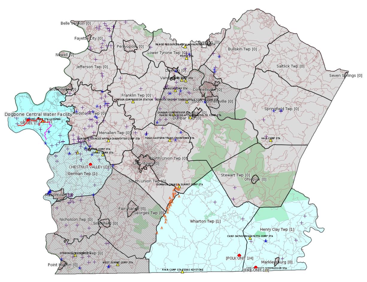
Fayette County Marcellus Shale Permits 7/24/17 - 8/6/17
Click the map to enlarge
Map
Key
Red dots: items in this permit list with an exact location.
Blue stars: Marcellus Gas Well Water Sources.
Municipality shading: number of "facilities", with each well counting separately
(includes the red dots):
Red dots: items in this permit list with an exact location.
Blue stars: Marcellus Gas Well Water Sources.
Municipality shading: number of "facilities", with each well counting separately
(includes the red dots):
gray: 0
pale turquoise: 1
turquoise: 2
pale blue: 3
middle blue: 4
dark blue: 6
dark purple: 10
purple: 19
(Color coding may differ from one issue to the next.)
(Note if a project spans multiple municipalities -- e.g. a pipeline -- it will show in the count for each municipality.)
The number of facilities also follows the municipality name in brackets.
Municipality counts are based on the way the permit is listed by DEP; DEP has been known to get a municipality wrong.
Locations in brackets identify a precise location used to locate a surrogate for the actual site being permitted (e.g. locating a well pad or pipeline by the known location of a well.) Locations labeled beginning with "~" and ending in "[?]" are approximate and speculative based on inferences using on-line property and lease records. These are marked in the text as "[Approximate, Speculative]
Cross-hatching: Environmental Justice Areas
Yellow triangles: Compressor Stations
Orange triangles: Storage Field Wells (currently Dominion North Summit Storage Field)
Crosses: Unconventional well permits (may not have been drilled)
Green: "Natural areas", e.g. state game lands, state forests
Yellow triangles: Compressor Stations
Orange triangles: Storage Field Wells (currently Dominion North Summit Storage Field)
Crosses: Unconventional well permits (may not have been drilled)
Green: "Natural areas", e.g. state game lands, state forests
More Maps
 |
 |
 |
Source: Pennsylvania Bulletin
Draft Technical Guidance—New Guidance
DEP ID: 310-2100-001. Title: Policy for State Water Quality Certification Issuance for Interstate Natural Gas Transmission Pipeline Projects Regulated by the Federal Energy Regulatory Commission. Description: The purpose of this draft technical guidance is to set forth the Department review process when an applicant requests a State Water Quality Certification for the Federal Energy Regulatory Commission (FERC) regulated interstate natural gas transmission pipeline project. Interstate natural gas transmission pipeline project applicants that require a Federal license from FERC must also, in accordance with section 401 of the Clean Water Act (33 U.S.C.A. § 1341) and section 3(d) of the Natural Gas Act (15 U.S.C.A. § 717b(d)), obtain a statement from the State certifying that the project will not violate State water quality standards as required by section 401 of the Clean Water Act. The Department will use this technical guidance to ensure that proposed interstate natural gas transmission pipeline projects regulated by FERC comply with State statutory and regulatory requirements necessary to protect the quality of the waters of the Commonwealth.
Written Comments: Interested persons may submit written comments on this draft policy no later than Monday, August 28, 2017. Comments submitted by facsimile will not be accepted. Comments, including comments submitted by e-mail, must include the commentator's name and address. Commentators are encouraged to submit comments using the Department's online eComment at http://www.ahs.dep.pa.gov/eComment or by e-mail to ecomment@pa.gov. Written comments should be submitted to the Technical Guidance Coordinator, Department of Environmental Protection, Policy Office, Rachel Carson State Office Building, 400 Market Street, Harrisburg, PA 17101.
Contact: Questions regarding this draft technical guidance may be directed to Kenneth Murin, Bureau of Waterways Engineering and Wetlands, (717) 787-3411.
Effective Date: Upon final publication of notice in the Pennsylvania Bulletin.
PATRICK McDONNELL,
Secretary
<http://www.pabulletin.com/secure/data/vol47/47-30/1261.html>
The actual document is available here:
<http://www.elibrary.dep.state.pa.us/dsweb/Get/Document-116811/310-2100-001.pdf>
-------------------------
Source: eNOTICE (+ PA Oil and Gas Mapping, Well Pad Report) Please see the Disclaimer below regarding Parcel Id data.
Authorization ID: 1170979
Permit number: 051-24633
Site:
Client: CHEVRON APPALACHIA LLC
Authorization type: Drill & Operate Well Permit (Unconventional)
Application type: Modification
Authorization is for: FACILITY
Date received: 02/24/2017
Status: Issued on 7/27/2017
Sub-Facilities for Authorization:
Sub-Facility ID Sub-Facility Name Description
1181842 SIEGEL 1 Well
Permit Review Notes:
Date Review Note
7/21/2017 The technical review and decision review are complete and either the permit decision and/or permit issuance are forthcoming.
7/20/2017 Applicant has been issued a deficiency letter. If applicable, this application no longer qualifies for the Permit Decision Guarantee.
6/14/2017 The permit application package is complete, has been accepted, and is undergoing technical review.
<http://www.ahs.dep.pa.gov/eFACTSWeb/searchResults_singleAuth.aspx?AuthID=1170979>
Well Details:
Permit Number: 051-24633Map URL: <http://www.openstreetmap.org/?mlat=39.968972&mlon=-79.968794#map=15/39.96897/-79.968794>
Well Name: SIEGEL 1
Unconventional Well: Y
Well Configuration: Vertical Well
Well Type: GAS
Well Status: Active
Coal Association: Coal
Conservation Well: N
Primary Facility ID: 803337
Site ID: 790384
Site Name: SIEGEL WELL PAD ESCGP-2 EXPEDITED
Well Pad ID: 0
Well Pad Name:
Storage Field:
Operator: CHEVRON APPALACHIA LLC
Operator Number: OGO-39307
Permit Date: 2015-08-12
Permit Date Expires: 2018-07-27
SPUD Date:
Date Plugged:
UIC ID:
UIC Type:
Surface Elevation: 1173
County: Fayette
Municipality: Luzerne Twp
Location: 39.968972,-79.968794
Presumed Parcel Id: 19240018
Modification Permit:
<http://www.depgis.state.pa.us/pdfHandler2/pdFHandler.ashx?Doc=NDc0MjUx&ext=PDF>
Permit Documents:
<http://www.depgis.state.pa.us/pdfHandler/pdFHandler.ashx?Doc=MjE0NjU4&ext=PDF>
<http://www.depgis.state.pa.us/eWellDocHandler/pdFHandler.ashx?Doc=MjI5NzY2>
<http://www.depgis.state.pa.us/eWellDocHandler/pdFHandler.ashx?Doc=MjI5NzY3>
<http://www.depgis.state.pa.us/eWellDocHandler/pdFHandler.ashx?Doc=MjI5ODMw>
Anticipated Maximum TVD: 7768 feet
[See Notes.]
---
Authorization ID: 1174655
Permit number: GP08260717-001
Site: LPR MIDSTREAM PARTNERS LLC POLK PIPELINE ESCGP ESG17-051-0001 & GP05 GP08
Client: LPR MIDSTREAM PARTNERS LLC
Authorization type: GP-08 Temporary Road Crossings
Application type: New
Authorization is for: FACILITY
Date received: 03/01/2017
Status: Pending
Sub-Facilities for Authorization:
Sub-Facility ID Sub-Facility Name Description
1230296 POLK PIPELINE PROJECT GP08260717-001 Bridge
Permit Review Notes:
Date Review Note
4/10/2017 Applicant has been issued a deficiency letter. If applicable, this application no longer qualifies for the Permit Decision Guarantee.
<http://www.ahs.dep.pa.gov/eFACTSWeb/searchResults_singleAuth.aspx?AuthID=1174655>
Municipalities: Henry Clay Twp, Wharton Twp
Location [of POLK UNIT 1H]: 39.746494,-79.529567 <http://osm.org/go/ZWpqHRIj--?m=>
Presumed Parcel Id: 4233000106
Location [of FIKE UNIT 1H]: 39.727028 -79.495752 <http://osm.org/go/ZWpqgA7n--?m=>
Parcel Id: 16190003
---
Authorization ID: 1179749
Permit number: WMGR123SW025
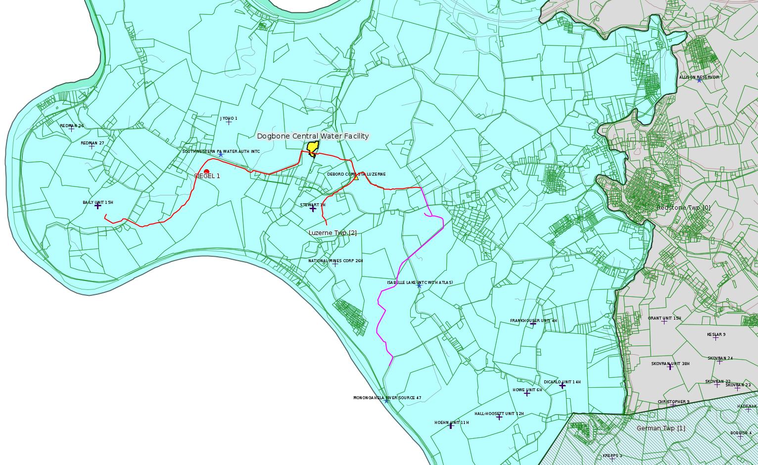
Site: DOGBONE CENTRALIZED WATER FACILITY
Client: CHEVRON APPALACHIA, LLC
Authorization type: RW General Permit Processing Registration
Application type: New
Authorization is for: FACILITY
Date received: 04/25/2017
Status: Pending
Sub-Facilities for Authorization:
Sub-Facility ID Sub-Facility Name Description
1232831 DOGBONE CENTRALIZED WATER FACILITY Processing Facility
Permit Review Notes:
Date Review Note
7/24/2017 Applicant has been issued a deficiency letter. If applicable, this application no longer qualifies for the Permit Decision Guarantee.
6/5/2017 Applicant has been issued a deficiency letter. If applicable, this application no longer qualifies for the Permit Decision Guarantee.
<http://www.ahs.dep.pa.gov/eFACTSWeb/searchResults_singleAuth.aspx?AuthID=1179749>
Location: 39.972496,-79.946939 <http://osm.org/go/ZWpZaULM--?m=>
Municipalities: Luzerne Twp
Presumed Parcel Id: 19160040
Fayette County Act 14 Notification: <http://faymarwatch.org/documents/SKM_554e17050309530.pdf>
[See Notes.]
---
Authorization ID: 1189541
Permit number: 100419
Site: CHESTNUT VALLEY LDFL
Client: ADVANCED DSPL SVC CHESTNUT VALLEY LDFL INC
Authorization type: Landfill Pmt Final Construction Certification Form 37
Application type: Modification
Authorization is for: FACILITY
Date received: 07/06/2017
Status: Pending
Permit Review Notes:
Date Review Note
7/25/2017 The permit application package is complete, has been accepted, and is undergoing technical review.
<http://www.ahs.dep.pa.gov/eFACTSWeb/searchResults_singleAuth.aspx?AuthID=1189541>
Location: 39.896765,-79.838766 <http://osm.org/go/ZWpP0~XK--?m=>
Municipalities: German Twp [an Environmental Justice Area]
Presumed Parcel Id: 15280012
-------------------------
Source: EPA PA Public Notices
[Out of County:]
Public Notice: Public Notice: Draft Permit: Penneco, LLC PAS2D701BALL
Summary
The United States Environmental Protection Agency (EPA) Region III plans to
issue one Underground Injection Control (UIC) Class II-D permit to Penneco
Environmental Solutions, LLC (Penneco) for disposal of fluids from
commercial oil and gas operations. These actions are being taken pursuant
to the Federal UIC regulations at 40 CFR Parts 124, 144, 146, and 147.The
new permit authorizes the conversion and operation of one former gas well
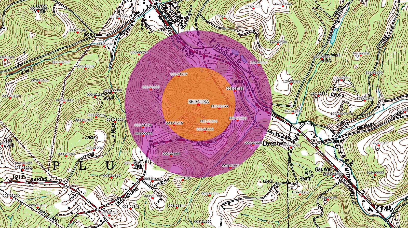
for use as UIC Class II-D commercial brine disposal injection well, Sedat
#3A, located in Plum Borough, Allegheny County, Pennsylvania.
Date extended to: 08/09/2017
How to Comment [Amended!]
To comment on the decision to issue this permit, you may submit a comment in writing to:
ATTN: James Bennett
U.S. Environmental Protection Agency
Region III Ground Water & Enforcement Branch (3WP22)
Water Protection Division
1650 Arch Street
Philadelphia, PA 19103
or by email message to:
bennett.james@epa.gov
until August 9, 2017.
<https://www.epa.gov/uic/public-notice-draft-permit-penneco-llc-pas2d701ball>
DEP eFACTS Record:
Authorization ID: 52215
Permit number: 003-21223
Site: SEDAT 3A WELL
Client: PENNECO OIL CO INC
Authorization type: Drill & Operate Well Permit
Application type: New
Authorization is for: FACILITY
Date received: 09/19/1988
Status: Issued on 9/19/1988
Sub-Facilities for Authorization:
Sub-Facility ID Sub-Facility Name Description
21234 SEDAT 3A Well
<http://www.ahs.dep.pa.gov/eFACTSWeb/searchResults_singleAuth.aspx?AuthID=52215>
Documents:
Public notice for penneco well permit number PAS2D701BALL:Well Details:
<https://www.epa.gov/sites/production/files/2017-06/documents/finaloptimizedforweb.penneco.publicnotice.6.22.17.pdf>
Statement of Basis for Penneco well permit number PAS2D701BALL:
<https://www.epa.gov/sites/production/files/2017-06/documents/finaloptimizedforweb.pennecosobmasterpas2d701ball.pdf>
Draft permit for penneco well permit number PAS2D701BALL:
<https://www.epa.gov/sites/production/files/2017-06/documents/finaloptimizedforweb.pennecodraftpermit06.22.17.pdf>
Administrative index for penneco well permit number PAS2D701BALL:
<https://www.epa.gov/sites/production/files/2017-06/documents/finaloptimizedforweb.administrative_record_-_penneco_sedat_3a.pdf>
Permit Number: 003-21223Map URL: <http://www.openstreetmap.org/?mlat=40.527385&mlon=-79.713485#map=15/40.527385/-79.713485>
Well Name: SEDAT 3A
Unconventional Well: N
Well Configuration: Vertical Well
Well Type: GAS
Well Status: Active
Coal Association: Coal
Conservation Well: N
Primary Facility ID: 7741
Site ID: 5993
Site Name: SEDAT 3A WELL
Well Pad ID: 0
Well Pad Name:
Storage Field:
Operator: PENNECO ENVIRONMENTAL SOLUTIONS LLC
Operator Number: OGO-40011
Permit Date: 1988-09-19
Permit Date Expires: 1989-09-19
SPUD Date: 1989-01-25
Date Plugged:
UIC ID:
UIC Type:
Surface Elevation: 1106
County: Allegheny
Municipality: Plum Boro
Location: 40.527385,-79.713485
[See Notes.]
-------------------------
Source: Reuters Commodities: Energy
Natural Gas
| Commodity | Exchange | Currency | Expire | Last Trade | Trade Time | Change | Open | Day's High | Day's Low |
|---|---|---|---|---|---|---|---|---|---|
| NATURAL
GAS CON1 Aug17 |
NYM | USD | 08/29 | 2.79 | 08/07 00:51 | +0.01 | 2.77 | 2.80 | 2.76 |
-------------------------
Notes:
The Modification Permit for Siegel 1 has a section Special Permit Conditions that includes this:
"WELL MAY PENETRATE VOID AREA (Pittsburgh coal seam). Use caution when drilling near potential void areas. If void areas are encountered, case and cement the well according to §78a.83, to prevent the migration of gas or other fluids into coal seam and notify your Oil & Gas Inspector."
---
For a letter from Fayette Marcellus Watcher Jim Rosenberg to DEP regarding the many problems of the application for the DOGBONE CENTRALIZED WATER FACILITY see:
<http://faymarwatch.org/documents/Dogbone_Water_System_DEP_full.pdf>
(This letter is a quite large document, but most of the length is taken by Act 14 notifications which DEP should already have but were provided for convenience.) It is not clear whether this letter is related to the 7/24/2017 deficiency letter.
Act 14 is a state law requiring applicants for several types of permits to notify every county and municipality in which the project will take place, and providing local government with a 30-day comment period. These permits typically do not allow any other type of public comment.
---
Although the Sedat 3A well which Penneco wants to repurpose as an injection well is in Allegheny County some distance from Fayette County, this is an important case which could serve as a precedent for unleashing injection wells in many places, including Fayette County. Historically, the geology of Western PA has been considered "not suitable" for injection wells. There is a clear scientific consensus that injection wells can cause earthquakes, which have happened in Ohio and Oklahoma. Historically injection wells have been quite deep, but this one is shallow. There is a great deal to worry about in this proposal.
For Fayette Marcellus Watcher Jim Rosenberg's written public comment on this application see:
<http://faymarwatch.org/documents/Sedat_3A_Injection_Well_Comment.pdf>
There is a discrepancy between EPA's "Basis Document" and Penneco's response to a Notice Of Deficiency regarding the radius of the AOR ("Area of Review"). Evidently EPA asked Penneco for an AOR of 0.5 miles instead of Penneco's proposal of 0.25 miles. (This was during the previous administration). Penneco provided an 0.5 mile AOR analysis, but then evidently EPA rolled back to Penneco's choice of 0.25 miles. The map shown above has the 0.25 mile AOR in orange, and the 0.5 mile AOR in purple.
------------------------
DEP defines an environmental justice area as "any census tract where 20 percent or more individuals live in poverty, and/or 30 percent or more of the population is minority". (See:
<http://www.dep.pa.gov/PublicParticipation/OfficeofEnvironmentalJustice/Pages/default.aspx>). There are supposed to be enhanced public participation requirements for permits in environmental justice areas, but news of this actually ever happening is scarce. In Fayette County, the entirety of Springhill, Nicholson, German, and Georges Townships are environmental justice areas, as well as a large part of Dunbar Township. DEP's policy document on public participation guidelines for environmental justice areas is located here:
<http://www.elibrary.dep.state.pa.us/dsweb/Get/Version-48671/012-0501-002.pdf>
eNOTICE records are likely to list the same permit multiple times, as that permit moves through the DEP process.
Oil & Gas Wells designated with a site a number and the letter H typically designate horizontal wells.
-------------------------
Resources:
Pennsylvania Bulletin: <http://www.pabulletin.com/>
eNOTICE: <http://www.ahs2.dep.state.pa.
DEP Oil and Gas Reports: <http://www.dep.pa.gov/DataandTools/Reports/Oil%20and%20Gas%20Reports/Pages/default.aspx>
DEP Well Details Report: <https://www.paoilandgasreport
Well Details may not show any
information for new permits and will not show permits which have
not yet been issued. Lookup for Well Details is by permit number.
DEP Permits Issued Detail Report:
<http://www.depreportingservic
DEP SPUD (drilling started) Report:
<http://www.depreportingservices.state.pa.us/ReportServer/Pages/ReportViewer.aspx?/Oil_Gas/Spud_External_Data>
DEP Oil and Gas Compliance Report:
<http://www.depreportingservices.state.pa.us/ReportServer/Pages/ReportViewer.aspx?/Oil_Gas/OG_Compliance>
DEP PA Oil & Gas Mapping:
<http://www.depgis.state.pa.us/PaOilAndGasMapping>
Data Portal Services Directory [Technical]
<http://www.depgis.state.pa.us/arcgis/rest/services>
Query: Oil and Gas Wells All (ID: 3) [Technical]:
<http://www.depgis.state.pa.us/arcgis/rest/services/OilGas/OilGasAllStrayGas/MapServer/3/query?where=&text=&objectIds=&time=&geometry=&geometryType=esriGeometryEnvelope&inSR=&spatialRel=esriSpatialRelIntersects&relationParam=&outFields=OBJECTID%2CPERMIT_NUMBER%2CWELL_NAME%2COPERATOR%2COPERATOR_NUMBER%2CWELL_TYPE%2CWELL_TYPE_CODE%2CWELL_STATUS%2CWELL_STATUS_CODE%2CPERMIT_DATE%2CPERMIT_DATE_EXPIRES%2CSPUD_DATE%2CCONSERVATION_IND%2CCOUNTY%2CCOUNTY_ID%2CMUNICIPALITY%2CMUNICIPALITY_TYPE%2CMUNICIPALITY_CODE%2CLATITUDE%2CLONGITUDE%2CPRMRY_FID%2CUNCONVENTIONAL_IND%2CSURFACE_ELEVATION%2CWELL_CONFIG_CODE%2CCOAL_IND%2CWELL_PAD_NAME%2CSHAPE%2CDATE_PLUGGED%2CWELL_PAD_ID%2CUIC_ID%2CUIC_TYPE_DESCRIPTION%2CSTORAGE_FIELD_NAME%2CSITE_ID%2CSITE_NAME&returnGeometry=true&returnTrueCurves=false&maxAllowableOffset=&geometryPrecision=&outSR=&returnIdsOnly=false&returnCountOnly=false&orderByFields=&groupByFieldsForStatistics=&outStatistics=&returnZ=false&returnM=false&gdbVersion=&returnDistinctValues=false&resultOffset=&resultRecordCount=&f=html>
(Be sure to enter a Where clause in SQL format. Dates are in milliseconds since midnight 1/1/1970).
DEP Oil and Gas Electronic Notifications
<http://www.depreportingservices.state.pa.us/ReportServer?/Oil_Gas/OG_Notifications>
DEP Oil and Gas Well Pad Report
<http://www.depreportingservices.state.pa.us/ReportServer?/Oil_Gas/Well_Pads>
Fayette County Assessment Office Search For Tax Records:
<http://property.co.fayette.pa.us/search.aspx>
Pennsylvania Spatial Data Access:
<http://www.pasda.psu.edu/default.asp>
DEP Spatial Data Repository:
<ftp://www.pasda.psu.edu/pub/pasda/dep/>
National Response Center:
<http://www.nrc.uscg.mil/>
EPA-Echo: <http://www.epa-echo.gov/echo/
FERC citizen involvement: <http://www.ferc.gov/for-citiz
To receive E-mail notification of
all documents filed in a FERC docket, see:
<http://www.ferc.gov/docs-filing/esubscription.asp >
<http://www.ferc.gov/docs-fili
Follow the directions and enter the docket number to subscribe to.
Township Supervisors receive information regarding Erosion & Sedimentation permits, and these records may be reviewable at township municipal offices.
DEP permits are reviewable through the File Review process, for application to do file review see: <http://www.portal.state.pa.us/portal/server.pt/community/southwest_regional_office/13775/file_review/593164>
Environmental Hearing Board: <http://ehb.courtapps.com/publ
PA DEP Environmental Policy Comment System:
<http://www.ahs.dep.pa.gov/eComment/>
Federal Register Environment: <https://www.federalregister.g
Browsing of recent comment
opportunities for federal agencies, e.g. EPA. Click "sign up" to
subscribe to daily E-mails of new document listings.
SkyTruth Fayette County Drilling Alerts: <http://frack.skytruth.org/pen
U.S. Army Corps of Engineers, Pittsburgh District, Public Notices:
<http://www.lrp.usace.army.mil/Missions/Regulatory/Public-Notices/>
EPA Pennsylvania Public Notices: <http://www2.epa.gov/aboutepa/epa-pennsylvania#notice>
Marcellus Shale waste disposal
injection wells in Pennsylvania are regulated directly by EPA, not
DEP. Notice of any new permit applications will appear at the
above web address. I'm not aware of any subscription service
to be notified of such applications. I'm not aware of any
Marcellus Shale waste disposal injection wells in Fayette County
(yet ...) but we need to monitor this page for future
applications.
Energy Assurance Daily: <http://www.oe.netl.doe.gov/ead.aspx>
Daily newsletter from the US
Department of Energy about events relating to energy. The Natural
Gas section has information about pipelines.
-------------------------
Disclaimers:
This compilation from the above sources was done by hand using copy and paste and may omit relevant permits.
Parcel data is provided via the tax records search web page offered by the Fayette County Assessment Office (http://property.co.fayette.pa.us/). Presumed Parcel Id links are subject to availability provided by that agency and associated web sites. Presumed Parcel Ids are determined as the mapped parcel containing a given latitude and longitude, are a best effort determination which is subject to error, and are not official. In cases where a facility is leased and there is a separate parcel id for the lease, if this parcel id is not separately mapped, the parcel id shown will be the id for the enclosing parcel. Parcel owners may be surface owners only and may or may not have any relationship to oil & gas facilities.
Does not currently include water supply permits. Does not include landfill permits even though many such are for Marcellus Shale waste. (It is not possible at this time to distinguish which landfill permits are for Marcellus Shale waste and which are not without doing File Review for each permit.)
Erosion & Sedimentation permit records do not currently include latitude and longitude. Where I am publishing latitude and longitude with E&S permits it is by inferring an associated well permit and using published latitude and longitude for the well. It is possible I may be inferring the wrong well site.
Municipalities are shown from eFACTS records on the DEP web site. The DEP has been known to list a municipality incorrectly.