The Harmed Success Stories Concepts How To What Is Commentary
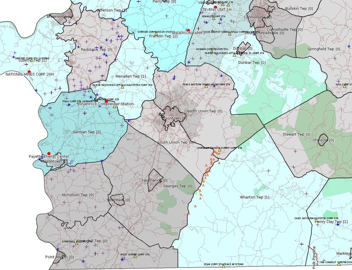
Fayette County Marcellus Shale Permits 8/21/17 - 9/3/17
Click the map to enlarge
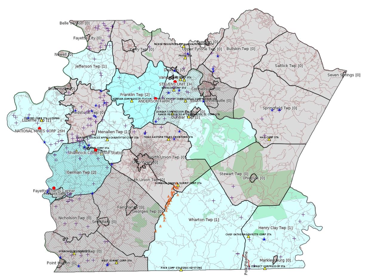
Map
Key
Red dots: items in this permit list with an exact location.
Blue stars: Marcellus Gas Well Water Sources.
Municipality shading: number of "facilities", with each well counting separately
(includes the red dots):
Red dots: items in this permit list with an exact location.
Blue stars: Marcellus Gas Well Water Sources.
Municipality shading: number of "facilities", with each well counting separately
(includes the red dots):
gray: 0
pale turquoise: 1
turquoise: 2
pale blue: 3
middle blue: 4
dark blue: 6
dark purple: 10
purple: 19
(Color coding may differ from one issue to the next.)
(Note if a project spans multiple municipalities -- e.g. a pipeline -- it will show in the count for each municipality.)
The number of facilities also follows the municipality name in brackets.
Municipality counts are based on the way the permit is listed by DEP; DEP has been known to get a municipality wrong.
Locations in brackets identify a precise location used to locate a surrogate for the actual site being permitted (e.g. locating a well pad or pipeline by the known location of a well.) Locations labeled beginning with "~" and ending in "[?]" are approximate and speculative based on inferences using on-line property and lease records. These are marked in the text as "[Approximate, Speculative]
Cross-hatching: Environmental Justice Areas
Yellow triangles: Compressor Stations
Orange triangles: Storage Field Wells (currently Dominion North Summit Storage Field)
Crosses: Unconventional well permits (may not have been drilled)
Green: "Natural areas", e.g. state game lands, state forests
Yellow triangles: Compressor Stations
Orange triangles: Storage Field Wells (currently Dominion North Summit Storage Field)
Crosses: Unconventional well permits (may not have been drilled)
Green: "Natural areas", e.g. state game lands, state forests
More Maps
 |
 |
Source: Pennsylvania Bulletin
PROPOSED RULEMAKING
ENVIRONMENTAL
QUALITY BOARD
Acceptance of Rulemaking Petition for Study
[47 Pa.B. 4986]
[Saturday, August 26, 2017]
On August 15, 2017, the Environmental Quality Board (Board) accepted a rulemaking petition for study under 25 Pa. Code Chapter 23 (relating to Environmental Quality Board policy for processing petitions—statement of policy). The petition, submitted by the Delaware Riverkeeper Network, requests the amendment of 25 Pa. Code Chapter 109 (relating to safe drinking water) to establish a maximum contaminant level for Perfluoro-octanoic Acid not to exceed six parts per trillion.
Under the Board's acceptance of the petition, the Department of Environmental Protection (Department) will prepare a report evaluating the petition. This report will include a recommendation on whether the Board should proceed with a proposed rulemaking and, if so, the process that the Department would need to undertake to develop a proposed rulemaking.
The previously-referenced petition is available to the public by contacting the Environmental Quality Board, P.O. Box 8477, Harrisburg, PA 17105-8477, (717) 787-4526, and is accessible on the Department's web site at www.dep.pa.gov (select ''Public Participation,'' then ''Environmental Quality Board (EQB),'' then ''2017 Meetings,'' under ''Meeting Agendas/Minutes/Handouts,'' see ''August 15, 2017'').
PATRICK McDONNELL,
Chairperson
<http://www.pabulletin.com/secure/data/vol47/47-34/1412.html>
---
PROPOSED RULEMAKING
[ 25 PA. CODE CH. 109 ]
Safe Drinking Water; General Update and Fees
[47 Pa.B. 4986]
[Saturday, August 26, 2017]
The Environmental Quality Board (Board) proposes to amend Chapter 109 (relating to safe drinking water) to read as set forth in Annex A. This proposed rulemaking includes three components:
• Incorporate the remaining general update provisions that were separated from the proposed Revised Total Coliform Rule (RTCR) as directed by the Board on April 21, 2015, including amendments to treatment technique requirements for pathogens, clarifications to permitting requirements, and new requirements for alarms, shutdown capabilities and auxiliary power.
• Amend existing permit fees and add new annual fees to supplement Commonwealth costs and fill the funding gap ($7.5 million).
• Establish the regulatory basis for issuing general permits, clarify that noncommunity water systems (NCWS) require a permit or approval from the Depart-ment of Environmental Protection (Department) prior to construction and operation, and address concerns regarding gaps in the monitoring, reporting and tracking of back-up sources of supply.
Collectively, this proposed rulemaking will provide for the increased protection of public health by every public water system (PWS) in this Commonwealth, and ensure that the Department has adequate funding to enforce the applicable drinking water laws, meet State and Federal minimum program elements, and retain primacy (primary enforcement authority).
Safe drinking water is vital to maintaining healthy and sustainable communities. Proactively avoiding incidents such as waterborne disease outbreaks can prevent loss of life, reduce the incidents of illness and reduce health care costs. Proper investment in PWS infrastructure and operations helps ensure a continuous supply of safe drinking water, enables communities to plan and build future capacity for economic growth, and ensures their long-term sustainability.
One or more of these proposed amendments will apply to all 8,521 PWSs in this Commonwealth.
[Details omitted.]
<http://www.pabulletin.com/secure/data/vol47/47-34/1413.html>
[This listing is enormous. Please see the link above for details.]
---
ESCGP-2 # ESG17-051-0021 [May be incorrect -- should be ESG17-051-0001?? -jr]
Applicant Name LPR Midstream Partners LLC
Contact Person Christy Fulton
Address 2 East Market Street
City, State, Zip Clearfield, PA 16830
County Fayette
Township(s) Wharton & Henry Clay
Receiving Stream(s) and Classification(s) UNTs to Fike
Run (HQ-CWF), Fike Run (HQ-CWF), UNTs to Little
Sandy Creek (HQ-CWF)
<http://www.pabulletin.com/secure/data/vol47/47-35/1452c.html>
Site: LPR MIDSTREAM PARTNERS LLC POLK PIPELINE ESCGP ESG17-051-0001 & GP05 GP08 [?]
[See Notes.]
-------------------------
Source: eNOTICE (+ PA Oil and Gas Mapping, Well Pad Report) Please see the Disclaimer below regarding Parcel Id data.
Authorization ID: 1172759
Permit number: ESX11-051-0016
Site: CONSTATINE TO LYNN PIPELINE ESCGP ESX11-051-0016 & GP5
Client: LAUREL MTN MIDSTREAM OPR LLC
Authorization type: Expedited E&S Stormwater General Permit 1
Application type: Amendment
Authorization is for: SITE
Date received: 03/03/2017
Status: Issued on 8/28/2017
Permit Review Notes:
Date Review Note
8/28/2017 The technical review and decision review are complete and either the permit decision and/or permit issuance are forthcoming.
8/5/2017 Applicant has been issued a deficiency letter. If applicable, this application no longer qualifies for the Permit Decision Guarantee.
5/18/2017 Applicant has been issued a deficiency letter. If applicable, this application no longer qualifies for the Permit Decision Guarantee.
5/17/2017 The permit application package is complete, has been accepted, and is undergoing technical review.
<http://www.ahs.dep.pa.gov/eFACTSWeb/searchResults_singleAuth.aspx?AuthID=1172759>
Municipalities: Franklin Twp, Jefferson Twp, Menallen Twp
Authorization ID: 1174654
Permit number: GP05260717-001
Site: LPR MIDSTREAM PARTNERS LLC POLK PIPELINE ESCGP ESG17-051-0001 & GP05 GP08
Client: LPR MIDSTREAM PARTNERS LLC
Authorization type: GP-05 Utility Line Stream Crossings
Application type: New
Authorization is for: FACILITY
Date received: 03/01/2017
Status: Pending
Sub-Facilities for Authorization:
Sub-Facility ID Sub-Facility Name Description
1230294 CROSSING #1 Pipeline or Conduit
1242611 CROSSING #10 Pipeline or Conduit
1242616 CROSSING #13 Pipeline or Conduit
1242618 CROSSING #14 Pipeline or Conduit
1242619 CROSSING #15 Pipeline or Conduit
1242620 CROSSING #16 Pipeline or Conduit
1242578 CROSSING #2 Pipeline or Conduit
1242579 CROSSING #3 Pipeline or Conduit
1242582 CROSSING #5 Pipeline or Conduit
1242584 CROSSING #6 Pipeline or Conduit
1242608 CROSSING #7 Pipeline or Conduit
1242610 CROSSING #9 Pipeline or Conduit
Permit Review Notes:
Date Review Note
4/10/2017 Applicant has been issued a deficiency letter. If applicable, this application no longer qualifies for the Permit Decision Guarantee.
<http://www.ahs.dep.pa.gov/eFACTSWeb/searchResults_singleAuth.aspx?AuthID=1174654>
Municipalities: Henry Clay Twp, Wharton Twp
Polk Pipeline Crossings Locations:
subfac_1230294 #1 39.74456,-79.5205
subfac_1242611 #10 39.73413,-79.5065
subfac_1242616 #13 39.7332,-79.50673
subfac_1242618 #14 39.72713,-79.50689
subfac_1242619 #15 39.72497,-79.50498
subfac_1242620 #16 39.72469,-79.5049
subfac_1242578 #2 39.740684,-79.51446
subfac_1242579 #3 39.740216,-79.51359
subfac_1242582 #5 39.73589,-79.50816
subfac_1242584 #6 39.73458,-79.50668
subfac_1242608 #7 39.73446,-79.50664
subfac_1242610 #9 39.73434,-79.50659
subfac_1242577 #1 39.74456,-79.5205
subfac_1242612 #10 39.73413,-79.5065
subfac_1242613 #11 39.73386,-79.50644
subfac_1242614 #12 39.7338,-79.50642
subfac_1242615 #13 39.7332,-79.50673
subfac_1242580 #4 39.739734,-79.51308
subfac_1242581 #5 39.73589,-79.50816
subfac_1242585 #6 39.73458,-79.50668
subfac_1242607 #7 39.73446,-79.50664
subfac_1242609 #8 39.73441,-79.50666
Authorization ID: 1174655
Permit number: GP08260717-001
Site: LPR MIDSTREAM PARTNERS LLC POLK PIPELINE ESCGP ESG17-051-0001 & GP05 GP08
Client: LPR MIDSTREAM PARTNERS LLC
Authorization type: GP-08 Temporary Road Crossings
Application type: New
Authorization is for: FACILITY
Date received: 03/01/2017
Status: Pending
Sub-Facilities for Authorization:
Sub-Facility ID Sub-Facility Name Description
1242577 CROSSING #1 Bridge
1242612 CROSSING #10 Bridge
1242613 CROSSING #11 Bridge
1242614 CROSSING #12 Bridge
1242615 CROSSING #13 Bridge
1242580 CROSSING #4 Bridge
1242581 CROSSING #5 Bridge
1242585 CROSSING #6 Bridge
1242607 CROSSING #7 Bridge
1242609 CROSSING #8 Bridge
1230296 POLK PIPELINE PROJECT GP08260717-001 Bridge
Permit Review Notes:
Date Review Note
4/10/2017 Applicant has been issued a deficiency letter. If applicable, this application no longer qualifies for the Permit Decision Guarantee.
<http://www.ahs.dep.pa.gov/eFACTSWeb/searchResults_singleAuth.aspx?AuthID=1174655>
Authorization ID: 1194648
Permit number: 26-00588A
Site: SHAMROCK COMP STA
Client: LAUREL MTN MIDSTREAM OPR LLC
Authorization type: Major Facility Plan Approval New Facility Review Prevention of Significant Deterioration
Application type: Extension
Authorization is for: FACILITY
Date received: 07/27/2017
Status: Issued on 8/28/2017
Sub-Facilities for Authorization:
Sub-Facility ID Sub-Facility Name Description
1020043 CATERPILLAR G3516B COMPRESSOR ENGINE #1 (1380 BHP) Process
1020044 CATERPILLAR G3516B COMPRESSOR ENGINE #2 (1380 BHP) Process
1020045 CATERPILLAR G3516B COMPRESSOR ENGINE #3 (1380 BHP) Process
1024425 CATERPILLAR G3516B COMPRESSOR ENGINE #4 (1380 BHP) Process
1024426 CATERPILLAR G3516B COMPRESSOR ENGINE #5 (1380 BHP) Process
1024427 CATERPILLAR G3516B COMPRESSOR ENGINE #6 (1380 BHP) Process
1087412 CATERPILLAR G3516B EMERGENCY GENERATOR (1,818 BHP) Process
1087413 CATERPILLAR G3516B EMERGENCY GENERATOR OXIDATION CATALYST Air Pollution Control Device
1024432 ENGINE #1 OXIDATION CATALYST Air Pollution Control Device
1024434 ENGINE #2 OXIDATION CATALYST Air Pollution Control Device
1024435 ENGINE #3 OXIDATION CATALYST Air Pollution Control Device
1024436 ENGINE #4 OXIDATION CATALYST Air Pollution Control Device
1024437 ENGINE #5 OXIDATION CATALYST Air Pollution Control Device
1024438 ENGINE #6 OXIDATION CATALYST Air Pollution Control Device
1024428 SOLAR MARS 100-16000S TURBINE (15,252 HP) Process
1024431 TEG DEHYDRATOR 1 (200 MMSCF/DAY) Process
1087369 TEG DEHYDRATOR 2 (200 MMSCF/DAY) Process
Permit Review Notes:
Date Review Note
8/28/2017 The technical review and decision review are complete and either the permit decision and/or permit issuance are forthcoming.
8/28/2017 The permit application package is complete, has been accepted, and is undergoing technical review.
<http://www.ahs.dep.pa.gov/eFACTSWeb/searchResults_singleAuth.aspx?AuthID=1194648>
Location: 39.918333,-79.825 <http://osm.org/go/ZWpasXGm--?m=>
Municipalities: German Twp [an Environmental Justice Area]
Parcel ID: 15140026
Authorization ID: 1194653
Permit number: 26-00588
Site: SHAMROCK COMP STA
Client: LAUREL MTN MIDSTREAM OPR LLC
Authorization type: Minor Facility Plan Approval New Source Performance Std
Application type: Extension
Authorization is for: FACILITY
Date received: 07/27/2017
Status: Issued on 8/28/2017
Sub-Facilities for Authorization:
Sub-Facility ID Sub-Facility Name Description
1020043 CATERPILLAR G3516B COMPRESSOR ENGINE #1 (1380 BHP) Process
1020044 CATERPILLAR G3516B COMPRESSOR ENGINE #2 (1380 BHP) Process
1020045 CATERPILLAR G3516B COMPRESSOR ENGINE #3 (1380 BHP) Process
1024425 CATERPILLAR G3516B COMPRESSOR ENGINE #4 (1380 BHP) Process
1024426 CATERPILLAR G3516B COMPRESSOR ENGINE #5 (1380 BHP) Process
1024427 CATERPILLAR G3516B COMPRESSOR ENGINE #6 (1380 BHP) Process
1024432 ENGINE #1 OXIDATION CATALYST Air Pollution Control Device
1024434 ENGINE #2 OXIDATION CATALYST Air Pollution Control Device
1024435 ENGINE #3 OXIDATION CATALYST Air Pollution Control Device
1024436 ENGINE #4 OXIDATION CATALYST Air Pollution Control Device
1024437 ENGINE #5 OXIDATION CATALYST Air Pollution Control Device
1024438 ENGINE #6 OXIDATION CATALYST Air Pollution Control Device
1024428 SOLAR MARS 100-16000S TURBINE (15,252 HP) Process
1024431 TEG DEHYDRATOR 1 (200 MMSCF/DAY) Process
Permit Review Notes:
Date Review Note
8/28/2017 The technical review and decision review are complete and either the permit decision and/or permit issuance are forthcoming.
8/28/2017 The permit application package is complete, has been accepted, and is undergoing technical review.
<http://www.ahs.dep.pa.gov/eFACTSWeb/searchResults_singleAuth.aspx?AuthID=1194653>
Authorization ID: 1195293
Permit number:
Site: NATIONAL MINES CORP 26H OG WELL
Client: CHEVRON APPALACHIA LLC
Authorization type: Residual Waste Processing
Application type: New
Authorization is for: FACILITY
Date received: 02/22/2017
Status: Issued on 8/23/2017
Sub-Facilities for Authorization:
Sub-Facility ID Sub-Facility Name Description
1242050 NATIONAL MINES CORP ALT RW Residual Waste Processing Locations
Permit Review Notes:
Date Review Note
8/23/2017 The technical review and decision review are complete and either the permit decision and/or permit issuance are forthcoming.
8/23/2017 The permit application package is complete, has been accepted, and is undergoing technical review.
<http://www.ahs.dep.pa.gov/eFACTSWeb/searchResults_singleAuth.aspx?AuthID=1195293>
Well Details:
Permit Number: 051-24365Map URL: <http://www.openstreetmap.org/?mlat=39.954019&mlon=-79.942361#map=15/39.954019/-79.942361>
Well Name: NATIONAL MINES CORP 26H
Unconventional Well: Y
Well Configuration: Horizontal Well
Well Type: GAS
Well Status: Active
Coal Association: Coal
Conservation Well: Y
Primary Facility ID: 731022
Site ID: 734804
Site Name: NATIONAL MINES CORP 26H OG WELL
Well Pad ID: 146298
Well Pad Name: NATIONAL MINES CORP 26H
Storage Field:
Operator: CHEVRON APPALACHIA LLC
Operator Number: OGO-39307
Permit Date: 2010-06-07
Permit Date Expires: 2011-06-07
SPUD Date: 2010-07-27
Date Plugged:
UIC ID:
UIC Type:
Surface Elevation: 1117
County: Fayette
Municipality: Luzerne Twp
Location: 39.954019,-79.942361
Presumed Parcel ID: 1925018602
[Arguably off-topic:]
Authorization ID: 1196179
Permit number: 26-00535B
Site: FAYETTE ENERGY FACILITY
Client: DYNEGY FAYETTE II, LLC
Authorization type: Major Facility Plan Approval New Source Performance Std
Application type: Extension
Authorization is for: FACILITY
Date received: 08/28/2017
Status: Pending
Sub-Facilities for Authorization:
Sub-Facility ID Sub-Facility Name Description
805954 CGT TRAIN 1 COMBINED CYCLE TURBINE Process
805959 CGT TRAIN 2 COMBINED CYCLE TURBINE Process
1095705 OXIDATION CATALYST UNIT 1 Air Pollution Control Device
1095706 OXIDATION CATALYST UNIT 2 Air Pollution Control Device
1095701 SCR UNIT 1 Air Pollution Control Device
1095702 SCR UNIT 2 Air Pollution Control Device
Permit Review Notes:
Date Review Note
9/1/2017 The technical review and decision review are complete and either the permit decision and/or permit issuance are forthcoming.
9/1/2017 The permit application package is complete, has been accepted, and is undergoing technical review.
<http://www.ahs.dep.pa.gov/eFACTSWeb/searchResults_singleAuth.aspx?AuthID=1196179>
Location: 39.857412,-79.913878 <http://osm.org/go/ZWpM9Ua6--?m=>
Municipalities: German Twp [an Environmental Justice Area], Masontown Boro
Presumed Parcel Id: 1530006703
-------------------------
Source: DEP Oil and Gas Compliance Report
[Conventional Well:]
OPERATOR: DAKOTA OIL & GAS CO
INSPECTION_ID: 2630469
INSPECTION_DATE: 08/01/2017
INSPECTION_TYPE: Incident- Response to Accident or Event
API_PERMIT: 051-23786
FARM_NAME: ANDERSON FARM 1
UNCONVENTIONAL: No
SITE_ID: 695339
SITE_NAME: ANDERSON FARM 1 OG WELL
FACILITY_TYPE: Oil & Gas Location
INSPECTION_CATEGORY: Primary Facility
REGION: EP DOGO SWDO Dstr Off
COUNTY: Fayette
MUNICIPALITY: Nicholson Twp
INSPECTOR: NAJEWICZ, JUSTIN
INSPECTION_SOURCE: SAIR
INSPECTION_RESULT_DESCRIPTION: Violation(s) Noted
INSPECTION_COMMENT: "On 07/25/17 Penneco Oil reported a spill of approximately 10 barrels of brine fluid. A groundhog had excavated below the tank causing it to fail. On 08/01/17 I conducted an incident response inspection. The impacted area had been excavated and soil samples had been collected at the time of inspection.
The spill has resulted in violations of 78.56(a)(3) and SWMA 301."
VIOLATION_ID: 795429
VIOLATION_DATE: 08/30/2017
VIOLATION_CODE: 78.56(a)3 - PITS AND TANKS FOR TEMPORARY CONTAINMENT - Operator failed to design, construct and maintain pits or tanks to be structurally sound.
VIOLATION_TYPE: Environmental Health & Safety
VIOLATION_COMMENT: Operator failed to maintain the integrity of the brine tank.
Well Details:
Permit Number: 051-23786Map URL: <http://www.openstreetmap.org/?mlat=40.000303&mlon=-79.697452#map=15/40.000303/-79.697452>
Well Name: ANDERSON FARM 1
Unconventional Well: N
Well Configuration: Vertical Well
Well Type: GAS
Well Status: Active
Coal Association: Coal
Conservation Well: N
Primary Facility ID: 698136
Site ID: 695339
Site Name: ANDERSON FARM 1 OG WELL
Well Pad ID: 0
Well Pad Name:
Storage Field:
Operator: DAKOTA OIL & GAS CO
Operator Number: OGO-39679
Permit Date: 2007-10-12
Permit Date Expires: 2008-10-12
SPUD Date: 2007-11-28
Date Plugged:
UIC ID:
UIC Type:
Surface Elevation: 1260
County: Fayette
Municipality: Nicholson Twp
Location: 40.000303,-79.697452 [See Notes! Either the municipality or lat/long is WRONG. -jr]
Presumed Parcel Id: 13140017
---
OPERATOR: XTO ENERGY INC
INSPECTION_ID: 2631026
INSPECTION_DATE: 08/03/2017
INSPECTION_TYPE: Routine/Complete Inspection
API_PERMIT: 051-24401
FARM_NAME: STEVENS UNIT 1H
UNCONVENTIONAL: Yes
SITE_ID: 741148
SITE_NAME: STEVENS UNIT 1H OG WELL
FACILITY_TYPE: Oil & Gas Location
INSPECTION_CATEGORY: Primary Facility
REGION: EP DOGO SWDO Dstr Off
COUNTY: Fayette
MUNICIPALITY: Dunbar Twp
INSPECTOR: NAJEWICZ, JUSTIN
INSPECTION_SOURCE: SAIR
INSPECTION_RESULT_DESCRIPTION: No Violations Noted
INSPECTION_COMMENT: The Act 9 sign was in place and all required documents were present at the site. XTO organized a meeting to discuss the restoration of the site and described the work to be completed. During the meeting I informed XTO that there is an outstanding violation from a spill at a drip tank associated with the site. XTO failed to enter in Act 2 or the alternate method and failed to perform a site characterization. XTO indicated they would initiate efforts to return to compliance.
Well Details:
Permit Number: 051-24401Map URL: <http://www.openstreetmap.org/?mlat=40.027158&mlon=-79.655672#map=15/40.027158/-79.655672>
Well Name: STEVENS UNIT 1H
Unconventional Well: Y
Well Configuration: Horizontal Well
Well Type: GAS
Well Status: Active
Coal Association: NonCoal
Conservation Well: N
Primary Facility ID: 735807
Site ID: 741148
Site Name: STEVENS UNIT 1H OG WELL
Well Pad ID: 149369
Well Pad Name: STEVENS UNIT
Storage Field:
Operator: XTO ENERGY INC
Operator Number: OGO-38958
Permit Date: 2010-12-14
Permit Date Expires: 2011-12-14
SPUD Date: 2011-03-21
Date Plugged:
UIC ID:
UIC Type:
Surface Elevation: 1145
County: Fayette
Municipality: Dunbar Twp
Location: 40.027158,-79.655672
Presumed Parcel Id: 09050277
[See Notes.]
-------------------------
Source: Reuters Commodities: Energy
Natural Gas
| Commodity | Exchange | Currency | Expire | Last Trade | Trade Time | Change | Open | Day's High | Day's Low |
|---|---|---|---|---|---|---|---|---|---|
| NATURAL
GAS CON1 Sep17 |
NYM | USD | 09/27 | 3.02 | 09/04 14:34 | -0.05 | 3.01 | 3.06 | 3.01 |
<http://www.reuters.com/finance/commodities/energy>
-------------------------
Notes:
eFACTS shows no authorizations for permit ESG17-051-0021. Meanwhile, authorization 1172242 for permit ESG17-051-0001 was issued on 8/14/2017. The permit number shown in the PA Bulletin listing above is almost certainly wrong.
The location for the well Anderson Farm 1 provided by the DEP Oil & Gas Mapping database does not agree with the recorded municipality, and it's not clear here which is wrong. The recorded latitude and longitude for this well show in Franklin Twp, but the municipality is showing as Nicholson Twp. The presumed parcel ID for the indicated lat/long is a parcel with the owner showing as having the name Anderson, so it's a reasonable guess that the lat/long are correct and the municipality is wrong. This is the way I am mapping it.
The issue referred to above for the Stevens Unit well pad was covered in the 3/6/16 issue of this bulletin, Inspection ID 2451281.
------------------------
DEP defines an environmental justice area as "any census tract where 20 percent or more individuals live in poverty, and/or 30 percent or more of the population is minority". (See:
<http://www.dep.pa.gov/PublicParticipation/OfficeofEnvironmentalJustice/Pages/default.aspx>). There are supposed to be enhanced public participation requirements for permits in environmental justice areas, but news of this actually ever happening is scarce. In Fayette County, the entirety of Springhill, Nicholson, German, and Georges Townships are environmental justice areas, as well as a large part of Dunbar Township. DEP's policy document on public participation guidelines for environmental justice areas is located here:
<http://www.elibrary.dep.state.pa.us/dsweb/Get/Version-48671/012-0501-002.pdf>
eNOTICE records are likely to list the same permit multiple times, as that permit moves through the DEP process.
Oil & Gas Wells designated with a site a number and the letter H typically designate horizontal wells.
-------------------------
Resources:
Pennsylvania Bulletin: <http://www.pabulletin.com/>
eNOTICE: <http://www.ahs2.dep.state.pa.
DEP Oil and Gas Reports: <http://www.dep.pa.gov/DataandTools/Reports/Oil%20and%20Gas%20Reports/Pages/default.aspx>
DEP Well Details Report: <https://www.paoilandgasreport
Well Details may not show any
information for new permits and will not show permits which have
not yet been issued. Lookup for Well Details is by permit number.
DEP Permits Issued Detail Report:
<http://www.depreportingservic
DEP SPUD (drilling started) Report:
<http://www.depreportingservices.state.pa.us/ReportServer/Pages/ReportViewer.aspx?/Oil_Gas/Spud_External_Data>
DEP Oil and Gas Compliance Report:
<http://www.depreportingservices.state.pa.us/ReportServer/Pages/ReportViewer.aspx?/Oil_Gas/OG_Compliance>
DEP PA Oil & Gas Mapping:
<http://www.depgis.state.pa.us/PaOilAndGasMapping>
Data Portal Services Directory [Technical]
<http://www.depgis.state.pa.us/arcgis/rest/services>
Query: Oil and Gas Wells All (ID: 3) [Technical]:
<http://www.depgis.state.pa.us/arcgis/rest/services/OilGas/OilGasAllStrayGas/MapServer/3/query?where=&text=&objectIds=&time=&geometry=&geometryType=esriGeometryEnvelope&inSR=&spatialRel=esriSpatialRelIntersects&relationParam=&outFields=OBJECTID%2CPERMIT_NUMBER%2CWELL_NAME%2COPERATOR%2COPERATOR_NUMBER%2CWELL_TYPE%2CWELL_TYPE_CODE%2CWELL_STATUS%2CWELL_STATUS_CODE%2CPERMIT_DATE%2CPERMIT_DATE_EXPIRES%2CSPUD_DATE%2CCONSERVATION_IND%2CCOUNTY%2CCOUNTY_ID%2CMUNICIPALITY%2CMUNICIPALITY_TYPE%2CMUNICIPALITY_CODE%2CLATITUDE%2CLONGITUDE%2CPRMRY_FID%2CUNCONVENTIONAL_IND%2CSURFACE_ELEVATION%2CWELL_CONFIG_CODE%2CCOAL_IND%2CWELL_PAD_NAME%2CSHAPE%2CDATE_PLUGGED%2CWELL_PAD_ID%2CUIC_ID%2CUIC_TYPE_DESCRIPTION%2CSTORAGE_FIELD_NAME%2CSITE_ID%2CSITE_NAME&returnGeometry=true&returnTrueCurves=false&maxAllowableOffset=&geometryPrecision=&outSR=&returnIdsOnly=false&returnCountOnly=false&orderByFields=&groupByFieldsForStatistics=&outStatistics=&returnZ=false&returnM=false&gdbVersion=&returnDistinctValues=false&resultOffset=&resultRecordCount=&f=html>
(Be sure to enter a Where clause in SQL format. Dates are in milliseconds since midnight 1/1/1970).
DEP Oil and Gas Electronic Notifications
<http://www.depreportingservices.state.pa.us/ReportServer?/Oil_Gas/OG_Notifications>
DEP Oil and Gas Well Pad Report
<http://www.depreportingservices.state.pa.us/ReportServer?/Oil_Gas/Well_Pads>
Fayette County Assessment Office Search For Tax Records:
<http://property.co.fayette.pa.us/search.aspx>
Pennsylvania Spatial Data Access:
<http://www.pasda.psu.edu/default.asp>
DEP Spatial Data Repository:
<ftp://www.pasda.psu.edu/pub/pasda/dep/>
National Response Center:
<http://www.nrc.uscg.mil/>
EPA-Echo: <http://www.epa-echo.gov/echo/
FERC citizen involvement: <http://www.ferc.gov/for-citiz
To receive E-mail notification of
all documents filed in a FERC docket, see:
<http://www.ferc.gov/docs-filing/esubscription.asp >
<http://www.ferc.gov/docs-fili
Follow the directions and enter the docket number to subscribe to.
Township Supervisors receive information regarding Erosion & Sedimentation permits, and these records may be reviewable at township municipal offices.
DEP permits are reviewable through the File Review process, for application to do file review see: <http://www.portal.state.pa.us/portal/server.pt/community/southwest_regional_office/13775/file_review/593164>
Environmental Hearing Board: <http://ehb.courtapps.com/publ
PA DEP Environmental Policy Comment System:
<http://www.ahs.dep.pa.gov/eComment/>
Federal Register Environment: <https://www.federalregister.g
Browsing of recent comment
opportunities for federal agencies, e.g. EPA. Click "sign up" to
subscribe to daily E-mails of new document listings.
SkyTruth Fayette County Drilling Alerts: <http://frack.skytruth.org/pen
U.S. Army Corps of Engineers, Pittsburgh District, Public Notices:
<http://www.lrp.usace.army.mil/Missions/Regulatory/Public-Notices/>
EPA Pennsylvania Public Notices: <http://www2.epa.gov/aboutepa/epa-pennsylvania#notice>
Marcellus Shale waste disposal
injection wells in Pennsylvania are regulated directly by EPA, not
DEP. Notice of any new permit applications will appear at the
above web address. I'm not aware of any subscription service
to be notified of such applications. I'm not aware of any
Marcellus Shale waste disposal injection wells in Fayette County
(yet ...) but we need to monitor this page for future
applications.
Energy Assurance Daily: <http://www.oe.netl.doe.gov/ead.aspx>
Daily newsletter from the US
Department of Energy about events relating to energy. The Natural
Gas section has information about pipelines.
-------------------------
Disclaimers:
This compilation from the above sources was done by hand using copy and paste and may omit relevant permits.
Parcel data is provided via the tax records search web page offered by the Fayette County Assessment Office (http://property.co.fayette.pa.us/). Presumed Parcel Id links are subject to availability provided by that agency and associated web sites. Presumed Parcel Ids are determined as the mapped parcel containing a given latitude and longitude, are a best effort determination which is subject to error, and are not official. In cases where a facility is leased and there is a separate parcel id for the lease, if this parcel id is not separately mapped, the parcel id shown will be the id for the enclosing parcel. Parcel owners may be surface owners only and may or may not have any relationship to oil & gas facilities.
Does not currently include water supply permits. Does not include landfill permits even though many such are for Marcellus Shale waste. (It is not possible at this time to distinguish which landfill permits are for Marcellus Shale waste and which are not without doing File Review for each permit.)
Erosion & Sedimentation permit records do not currently include latitude and longitude. Where I am publishing latitude and longitude with E&S permits it is by inferring an associated well permit and using published latitude and longitude for the well. It is possible I may be inferring the wrong well site.
Municipalities are shown from eFACTS records on the DEP web site. The DEP has been known to list a municipality incorrectly.