The Harmed Success Stories Concepts How To What Is Commentary
Fayette County Marcellus Shale Permits 9/4/17 - 9/17/17
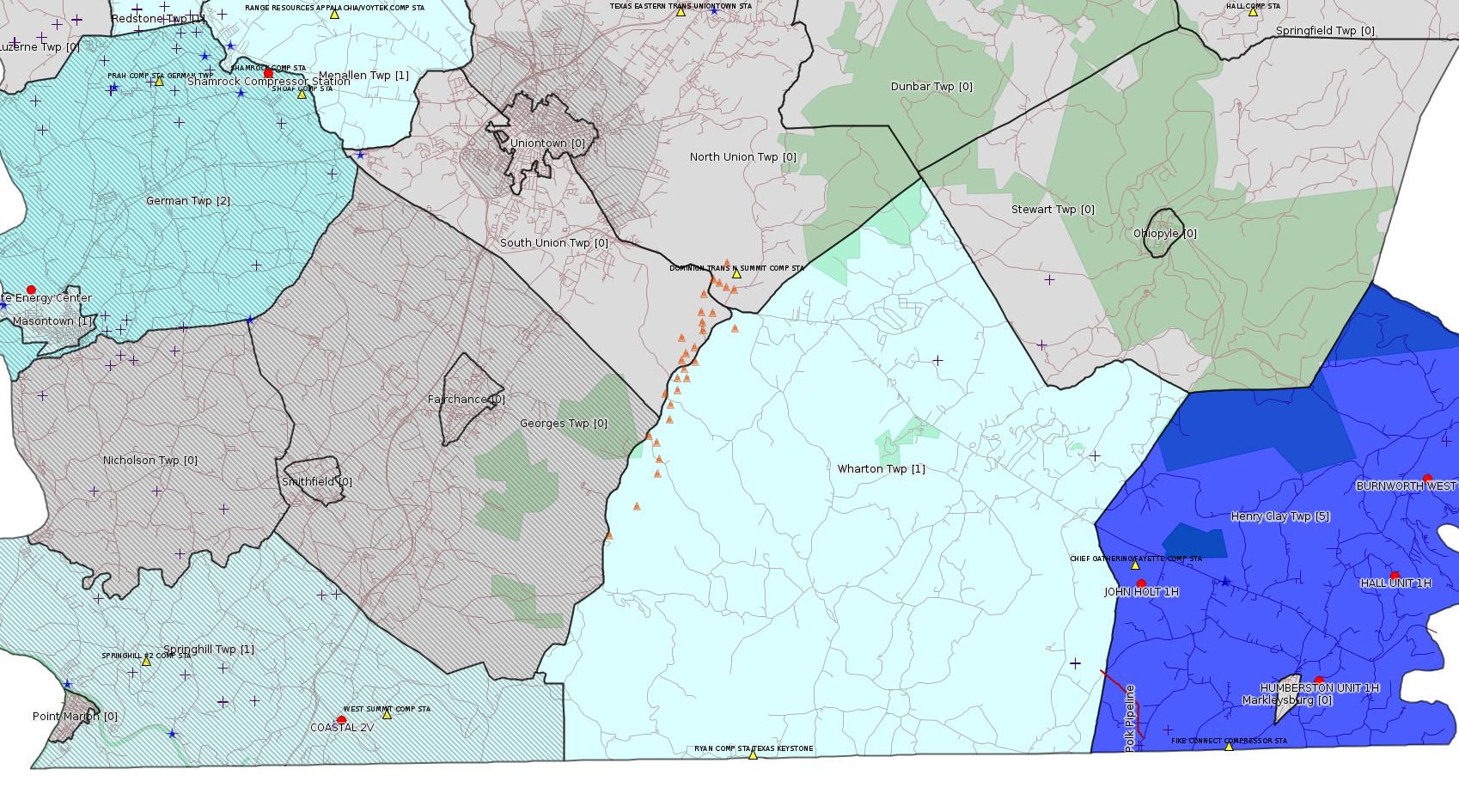
Click the map to enlarge
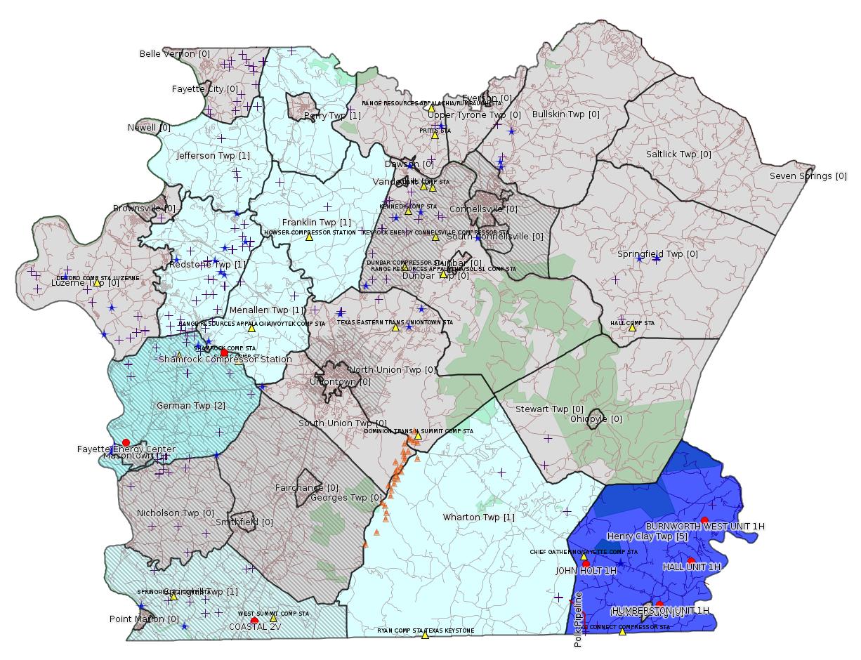
Map
Key
Red dots: items in this permit list with an exact location.
Blue stars: Marcellus Gas Well Water Sources.
Municipality shading: number of "facilities", with each well counting separately
(includes the red dots):
Red dots: items in this permit list with an exact location.
Blue stars: Marcellus Gas Well Water Sources.
Municipality shading: number of "facilities", with each well counting separately
(includes the red dots):
gray: 0
pale turquoise: 1
turquoise: 2
pale blue: 3
middle blue: 4
dark blue: 6
dark purple: 10
purple: 19
(Color coding may differ from one issue to the next.)
(Note if a project spans multiple municipalities -- e.g. a pipeline -- it will show in the count for each municipality.)
The number of facilities also follows the municipality name in brackets.
Municipality counts are based on the way the permit is listed by DEP; DEP has been known to get a municipality wrong.
Locations in brackets identify a precise location used to locate a surrogate for the actual site being permitted (e.g. locating a well pad or pipeline by the known location of a well.) Locations labeled beginning with "~" and ending in "[?]" are approximate and speculative based on inferences using on-line property and lease records. These are marked in the text as "[Approximate, Speculative]
Cross-hatching: Environmental Justice Areas
Yellow triangles: Compressor Stations
Orange triangles: Storage Field Wells (currently Dominion North Summit Storage Field)
Crosses: Unconventional well permits (may not have been drilled)
Green: "Natural areas", e.g. state game lands, state forests
Yellow triangles: Compressor Stations
Orange triangles: Storage Field Wells (currently Dominion North Summit Storage Field)
Crosses: Unconventional well permits (may not have been drilled)
Green: "Natural areas", e.g. state game lands, state forests
More Maps
 |
Source: Pennsylvania Bulletin
ESCGP-2 # ESX11-051-0016 Renewal
Applicant Name Laurel Mountain Midstream, LLC
Contact Person Stephanie Ranker
Address 111 Enterprise Lane
City, State, Zip Connellsville, PA 15425
County Fayette County & Westmoreland County
Township(s) Rostraver Township (Westmoreland County
& Franklin, Jefferson, Menallen, Perry and Redstone
Townships, Fayette County
Receiving Stream(s) and Classification(s) UNTs to
Mudlick Fork (TSF)
<http://www.pabulletin.com/secure/data/vol47/47-36/1478e.html>
Site: CONSTATINE TO LYNN PIPELINE ESCGP ESX11-051-0016 & GP5
[See Notes.]
---
[Arguably off-topic:]
26-00535B: Dynegy Fayette II, LLC (100 Energy Drive, Masontown, PA 15461) Extension effective September 1, 2017, to allow continued temporary operation of the modified combustion gas turbines (''CGT'') at Fayette Energy Center located in Masontown Borough, Fayette County. Components of the turbine section have been replaced and combustion control logic change to increase combustion air flow.
<http://www.pabulletin.com/secure/data/vol47/47-37/1522c.html>
Location: 39.857412,-79.913878 <http://osm.org/go/ZWpM9Ua6--?m=>
Municipalities: German Twp [an Environmental Justice Area], Masontown Boro
Presumed Parcel Id: 1530006703
---
26-00588A: Laurel Mountain Midstream Operating, LLC (1550 Coraopolis Heights Road, Suite 140, Moon Township, PA 15108) Extension effective August 28, 2017, to extend the period of temporary operation of the new dehydrator and emergency generator authorized under plan approval PA-26-00588A at Shamrock Compressor Station located in German Township, Fayette County. One Solar Titan 130 turbine rated at 19,553 HP and originally authorized to be installed at this facility under PA-26-00588A is no longer authorized as the 18-month period to commence construction specified under 25 Pa. Code § 127.13(b) has passed.
<http://www.pabulletin.com/secure/data/vol47/47-37/1522c.html>
Location: 39.918333,-79.825 <http://osm.org/go/ZWpasXGm--?m=>
Municipalities: German Twp [an Environmental Justice Area]
Parcel ID: 15140026
---
26-00588: Laurel Mountain Midstream Operating, LLC (1550 Coraopolis Heights Road, Suite 140, Moon Township, PA 15108) Extension effective August 28, 2017, to extend the period of temporary operation of the three Caterpillar G3516B natural gas-fired compressor engines rated at 1,380 bhp each and controlled by oxidation catalysts, and a Solar Mars 100 gas-fired turbine rated at 15,525 bhp authorized under plan approval PA-26-00588 at Shamrock Compressor Station located in German Township, Fayette County.
<http://www.pabulletin.com/secure/data/vol47/47-37/1522c.html>
-------------------------
Source: eNOTICE (+ PA Oil and Gas Mapping, Well Pad Report) Please see the Disclaimer below regarding Parcel Id data.
Authorization ID: 1174654
Permit number: GP05260717-001
Site: LPR MIDSTREAM PARTNERS LLC POLK PIPELINE ESCGP ESG17-051-0001 & GP05 GP08
Client: LPR MIDSTREAM PARTNERS LLC
Authorization type: GP-05 Utility Line Stream Crossings
Application type: New
Authorization is for: FACILITY
Date received: 03/01/2017
Status: Issued on 9/5/2017
Sub-Facilities for Authorization:
Sub-Facility ID Sub-Facility Name Description
1230294 CROSSING #1 Pipeline or Conduit
1242611 CROSSING #10 Pipeline or Conduit
1242616 CROSSING #13 Pipeline or Conduit
1242618 CROSSING #14 Pipeline or Conduit
1242619 CROSSING #15 Pipeline or Conduit
1242620 CROSSING #16 Pipeline or Conduit
1242578 CROSSING #2 Pipeline or Conduit
1242579 CROSSING #3 Pipeline or Conduit
1242582 CROSSING #5 Pipeline or Conduit
1242584 CROSSING #6 Pipeline or Conduit
1242608 CROSSING #7 Pipeline or Conduit
1242610 CROSSING #9 Pipeline or Conduit
Permit Review Notes:
Date Review Note
9/5/2017 The technical review and decision review are complete and either the permit decision and/or permit issuance are forthcoming.
4/10/2017 Applicant has been issued a deficiency letter. If applicable, this application no longer qualifies for the Permit Decision Guarantee.
<http://www.ahs.dep.pa.gov/eFACTSWeb/searchResults_singleAuth.aspx?AuthID=1174654>
Municipalities: Henry Clay Twp, Wharton Twp
Polk Pipeline Crossings Locations:
subfac_1230294 #1 39.74456,-79.5205
subfac_1242611 #10 39.73413,-79.5065
subfac_1242616 #13 39.7332,-79.50673
subfac_1242618 #14 39.72713,-79.50689
subfac_1242619 #15 39.72497,-79.50498
subfac_1242620 #16 39.72469,-79.5049
subfac_1242578 #2 39.740684,-79.51446
subfac_1242579 #3 39.740216,-79.51359
subfac_1242582 #5 39.73589,-79.50816
subfac_1242584 #6 39.73458,-79.50668
subfac_1242608 #7 39.73446,-79.50664
subfac_1242610 #9 39.73434,-79.50659
subfac_1242577 #1 39.74456,-79.5205
subfac_1242612 #10 39.73413,-79.5065
subfac_1242613 #11 39.73386,-79.50644
subfac_1242614 #12 39.7338,-79.50642
subfac_1242615 #13 39.7332,-79.50673
subfac_1242580 #4 39.739734,-79.51308
subfac_1242581 #5 39.73589,-79.50816
subfac_1242585 #6 39.73458,-79.50668
subfac_1242607 #7 39.73446,-79.50664
subfac_1242609 #8 39.73441,-79.50666
Authorization ID: 1174655
Permit number: GP08260717-001
Site: LPR MIDSTREAM PARTNERS LLC POLK PIPELINE ESCGP ESG17-051-0001 & GP05 GP08
Client: LPR MIDSTREAM PARTNERS LLC
Authorization type: GP-08 Temporary Road Crossings
Application type: New
Authorization is for: FACILITY
Date received: 03/01/2017
Status: Issued on 9/5/2017
Sub-Facilities for Authorization:
Sub-Facility ID Sub-Facility Name Description
1242577 CROSSING #1 Bridge
1242612 CROSSING #10 Bridge
1242613 CROSSING #11 Bridge
1242614 CROSSING #12 Bridge
1242615 CROSSING #13 Bridge
1242580 CROSSING #4 Bridge
1242581 CROSSING #5 Bridge
1242585 CROSSING #6 Bridge
1242607 CROSSING #7 Bridge
1242609 CROSSING #8 Bridge
1230296 POLK PIPELINE PROJECT GP08260717-001 Bridge
Permit Review Notes:
Date Review Note
9/5/2017 The technical review and decision review are complete and either the permit decision and/or permit issuance are forthcoming.
4/10/2017 Applicant has been issued a deficiency letter. If applicable, this application no longer qualifies for the Permit Decision Guarantee.
<http://www.ahs.dep.pa.gov/eFACTSWeb/searchResults_singleAuth.aspx?AuthID=1174655>
Authorization ID: 1191327
Permit number: 051-24636
Site: COASTAL 1H FLOW BACK PIT FRESHWATER PITS ESCGP-EXPEDITED
Client: BURNETT OIL CO INC
Authorization type: Drill & Operate Well Permit
Application type: Renewal
Authorization is for: FACILITY
Date received: 05/11/2017
Status: Pending
Permit Review Notes:
Date Review Note
9/15/2017 The technical review and decision review are complete and either the permit decision and/or permit issuance are forthcoming.
7/21/2017 The permit application package is complete, has been accepted, and is undergoing technical review.
<http://www.ahs.dep.pa.gov/eFACTSWeb/searchResults_singleAuth.aspx?AuthID=1191327>
Well Details:
Permit Number: 051-24636Map URL: <http://www.openstreetmap.org/?mlat=39.733336&mlon=-79.800886#map=15/39.733336/-79.800886>
Well Name: COASTAL 2V
Unconventional Well: N
Well Configuration: Vertical Well
Well Type: GAS
Well Status: Active
Coal Association: NonCoal
Conservation Well: Y
Primary Facility ID: 808138
Site ID: 739525
Site Name: COASTAL 1H FLOW BACK PIT FRESHWATER PITS ESCGP-EXPEDITED
Well Pad ID: 152060
Well Pad Name: COASTAL
Storage Field:
Operator: BURNETT OIL CO INC
Operator Number: OGO-39119
Permit Date: 2016-06-22
Permit Date Expires: 2017-06-22
SPUD Date:
Date Plugged:
UIC ID:
UIC Type:
Surface Elevation: 1130
County: Fayette
Municipality: Springhill Twp [an Environmental Justice Area]
Location: 39.733336,-79.800886
Presumed Parcel Id: 36210048
Original Full Permit:
<http://www.depgis.state.pa.us/pdfHandler/pdFHandler.ashx?Doc=MzY5MDA5&ext=PDF>
Anticipated Maximum TVD: 8000 feet
Authorization ID: 1196179
Permit number: 26-00535B
Site: FAYETTE ENERGY FACILITY
Client: DYNEGY FAYETTE II, LLC
Authorization type: Major Facility Plan Approval New Source Performance Std
Application type: Extension
Authorization is for: FACILITY
Date received: 08/28/2017
Status: Issued on 9/1/2017
Sub-Facilities for Authorization:
Sub-Facility ID Sub-Facility Name Description
805954 CGT TRAIN 1 COMBINED CYCLE TURBINE Process
805959 CGT TRAIN 2 COMBINED CYCLE TURBINE Process
1095705 OXIDATION CATALYST UNIT 1 Air Pollution Control Device
1095706 OXIDATION CATALYST UNIT 2 Air Pollution Control Device
1095701 SCR UNIT 1 Air Pollution Control Device
1095702 SCR UNIT 2 Air Pollution Control Device
Permit Review Notes:
Date Review Note
9/1/2017 The technical review and decision review are complete and either the permit decision and/or permit issuance are forthcoming.
9/1/2017 The permit application package is complete, has been accepted, and is undergoing technical review.
<http://www.ahs.dep.pa.gov/eFACTSWeb/searchResults_singleAuth.aspx?AuthID=1196179>
[Location above]
Authorization ID: 1196687
Permit number: [051-24400 -jr]
Site: BURNWORTH WEST UNIT 1H OG WELL
Client: LPR ENERGY LLC
Authorization type: Drill & Operate Well Permit Inactive Status
Application type: New
Authorization is for: FACILITY
Date received: 08/25/2017
Status: Issued on 9/6/2017
Sub-Facilities for Authorization:
Sub-Facility ID Sub-Facility Name Description
1023091 BURNWORTH WEST UNIT 1H Well
Permit Review Notes:
Date Review Note
8/25/2017 The technical review and decision review are complete and either the permit decision and/or permit issuance are forthcoming.
8/25/2017 The permit application package is complete, has been accepted, and is undergoing technical review.
<http://www.ahs.dep.pa.gov/eFACTSWeb/searchResults_singleAuth.aspx?AuthID=1196687>
Well Details:
Permit Number: 051-24400Map URL: <http://www.openstreetmap.org/?mlat=39.797503&mlon=-79.398014#map=15/39.797503/-79.398014>
Well Name: BURNWORTH WEST UNIT 1H
Unconventional Well: Y
Well Configuration: Horizontal Well
Well Type: GAS
Well Status: Regulatory Inactive Status
Coal Association: NonCoal
Conservation Well: N
Primary Facility ID: 735586
Site ID: 740856
Site Name: BURNWORTH WEST UNIT 1H OG WELL
Well Pad ID: 147087
Well Pad Name: BURNWORTH WEST UNIT 1H
Storage Field:
Operator: LPR ENERGY LLC
Operator Number: OGO-68579
Permit Date: 2010-11-24
Permit Date Expires: 2011-11-24
SPUD Date: 2011-03-01
Date Plugged:
UIC ID:
UIC Type:
Surface Elevation: 1950
County: Fayette
Municipality: Henry Clay Twp
Location: 39.797503,-79.398014
Presumed Parcel Id: 16090032
[See Notes.]
Authorization ID: 1196689
Permit number: [051-24403 -jr]
Site: HALL UNIT 1H OG WELL
Client: LPR ENERGY LLC
Authorization type: Drill & Operate Well Permit Inactive Status
Application type: New
Authorization is for: FACILITY
Date received: 08/18/2017
Status: Issued on 9/6/2017
Sub-Facilities for Authorization:
Sub-Facility ID Sub-Facility Name Description
1023640 HALL UNIT 1H Well
Permit Review Notes:
Date Review Note
8/18/2017 The technical review and decision review are complete and either the permit decision and/or permit issuance are forthcoming.
8/18/2017 The permit application package is complete, has been accepted, and is undergoing technical review.
<http://www.ahs.dep.pa.gov/eFACTSWeb/searchResults_singleAuth.aspx?AuthID=1196689>
Well Details:
Permit Number: 051-24403Map URL: <http://www.openstreetmap.org/?mlat=39.769889&mlon=-79.410881#map=15/39.769889/-79.410881>
Well Name: HALL UNIT 1H
Unconventional Well: Y
Well Configuration: Horizontal Well
Well Type: GAS
Well Status: Regulatory Inactive Status
Coal Association: NonCoal
Conservation Well: N
Primary Facility ID: 735848
Site ID: 741195
Site Name: HALL UNIT 1H OG WELL
Well Pad ID: 148468
Well Pad Name: HALL UNIT 1H
Storage Field:
Operator: LPR ENERGY LLC
Operator Number: OGO-68579
Permit Date: 2010-11-24
Permit Date Expires: 2011-11-24
SPUD Date: 2011-03-21
Date Plugged:
UIC ID:
UIC Type:
Surface Elevation: 1965
County: Fayette
Municipality: Henry Clay Twp
Location: 39.769889,-79.410881
Presumed Parcel Id: 16130134
Authorization ID: 1196693
Permit number: [051-24367 -jr]
Site: HUMBERSTON UNIT 1H OG WELL
Client: LPR ENERGY LLC
Authorization type: Drill & Operate Well Permit Inactive Status
Application type: New
Authorization is for: FACILITY
Date received: 08/18/2017
Status: Issued on 9/6/2017
Sub-Facilities for Authorization:
Sub-Facility ID Sub-Facility Name Description
1015955 HUMBERSTON UNIT 1H Well
Permit Review Notes:
Date Review Note
9/6/2017 The technical review and decision review are complete and either the permit decision and/or permit issuance are forthcoming.
8/18/2017 The permit application package is complete, has been accepted, and is undergoing technical review.
<http://www.ahs.dep.pa.gov/eFACTSWeb/searchResults_singleAuth.aspx?AuthID=1196693>
Well Details:
Permit Number: 051-24367Map URL: <http://www.openstreetmap.org/?mlat=39.740383&mlon=-79.439622#map=15/39.740383/-79.439622>
Well Name: HUMBERSTON UNIT 1H
Unconventional Well: Y
Well Configuration: Horizontal Well
Well Type: GAS
Well Status: Regulatory Inactive Status
Coal Association: Coal
Conservation Well: N
Primary Facility ID: 731775
Site ID: 735895
Site Name: HUMBERSTON UNIT 1H OG WELL
Well Pad ID: 146309
Well Pad Name: HUMBERSTON UNIT 1H
Storage Field:
Operator: LPR ENERGY LLC
Operator Number: OGO-68579
Permit Date: 2010-07-13
Permit Date Expires: 2011-07-13
SPUD Date: 2011-01-28
Date Plugged:
UIC ID:
UIC Type:
Surface Elevation: 2000
County: Fayette
Municipality: Henry Clay Twp
Location: 39.740383,-79.439622
Presumed Parcel Id: 16160099
Authorization ID: 1196694
Permit number: 051-24140
Site: JOHN HOLT 1H OG WEL
Client: LPR ENERGY LLC
Authorization type: Drill & Operate Well Permit Inactive Status
Application type: New
Authorization is for: FACILITY
Date received: 08/18/2017
Status: Issued on 9/6/2017
Sub-Facilities for Authorization:
Sub-Facility ID Sub-Facility Name Description
981790 JOHN HOLT 1H Well
Permit Review Notes:
Date Review Note
9/6/2017 The technical review and decision review are complete and either the permit decision and/or permit issuance are forthcoming.
8/18/2017 The permit application package is complete, has been accepted, and is undergoing technical review.
<http://www.ahs.dep.pa.gov/eFACTSWeb/searchResults_singleAuth.aspx?AuthID=1196694>
Well Details:
Permit Number: 051-24140Map URL: <http://www.openstreetmap.org/?mlat=39.768936&mlon=-79.504661#map=15/39.768936/-79.504661>
Well Name: JOHN HOLT 1H
Unconventional Well: Y
Well Configuration: Vertical Well
Well Type: GAS
Well Status: Regulatory Inactive Status
Coal Association: NonCoal
Conservation Well: Y
Primary Facility ID: 713811
Site ID: 714731
Site Name: JOHN HOLT 1H OG WEL
Well Pad ID: 146975
Well Pad Name: JOHN HOLT 1H
Storage Field:
Operator: LPR ENERGY LLC
Operator Number: OGO-68579
Permit Date: 2008-12-24
Permit Date Expires: 2009-12-24
SPUD Date: 2009-04-02
Date Plugged:
UIC ID:
UIC Type:
Surface Elevation: 2325
County: Fayette
Municipality: Henry Clay Twp
Location: 39.768936,-79.504661
Presumed Parcel Id: 16100009
-------------------------
Source: Reuters Commodities: Energy
Natural Gas
| Commodity | Exchange | Currency | Expire | Last Trade | Trade Time | Change | Open | Day's High | Day's Low |
|---|---|---|---|---|---|---|---|---|---|
| NATURAL
GAS CON1 Sep17 |
NYM | USD | 09/27 | 3.07 | 09/16 22:56 | +0.04 | 3.05 | 3.07 | 3.05 |
<http://www.reuters.com/finance/commodities/energy>
-------------------------
Notes:
The 4 wells listed in this bulletin for Drill & Operate Well Permit Inactive Status by LPR Energy were already in Regulatory Inactive Status. These appear to be wells that originally belonged to Chief Oil & Gas and were then acquired by Chevron. It's not clear why they need new applications for Inactive Status unless the reason is simply their acquisition by LPR Energy.
The Authorization Record for renewal of the site CONSTATINE TO LYNN PIPELINE ESCGP ESX11-051-0016 & GP5 was listed in the previous issue of this bulletin; the municipalities given in the Site Record disagree with the list of municipalities in the PA Bulletin listing above -- the PA Bulletin listing includes Perry and Redstone Townships, which are missing from the Site Record. This kind of discrepancy is very frustrating. Under a State Law called Act 14, companies are required to notify every county and municipality in which certain projects are to occur. DEP is tasked with auditing whether such notification has happened. (A copy of the certified mail receipt is supposed to be submitted with the permit application.) How can DEP responsibly audit Act 14 compliance if they can't even keep consistent records of which municipalities are involved in a project?
------------------------
DEP defines an environmental justice area as "any census tract where 20 percent or more individuals live in poverty, and/or 30 percent or more of the population is minority". (See:
<http://www.dep.pa.gov/PublicParticipation/OfficeofEnvironmentalJustice/Pages/default.aspx>). There are supposed to be enhanced public participation requirements for permits in environmental justice areas, but news of this actually ever happening is scarce. In Fayette County, the entirety of Springhill, Nicholson, German, and Georges Townships are environmental justice areas, as well as a large part of Dunbar Township. DEP's policy document on public participation guidelines for environmental justice areas is located here:
<http://www.elibrary.dep.state.pa.us/dsweb/Get/Version-48671/012-0501-002.pdf>
eNOTICE records are likely to list the same permit multiple times, as that permit moves through the DEP process.
Oil & Gas Wells designated with a site a number and the letter H typically designate horizontal wells.
-------------------------
Resources:
Pennsylvania Bulletin: <http://www.pabulletin.com/>
eNOTICE: <http://www.ahs2.dep.state.pa.
DEP Oil and Gas Reports: <http://www.dep.pa.gov/DataandTools/Reports/Oil%20and%20Gas%20Reports/Pages/default.aspx>
DEP Well Details Report: <https://www.paoilandgasreport
Well Details may not show any
information for new permits and will not show permits which have
not yet been issued. Lookup for Well Details is by permit number.
DEP Permits Issued Detail Report:
<http://www.depreportingservic
DEP SPUD (drilling started) Report:
<http://www.depreportingservices.state.pa.us/ReportServer/Pages/ReportViewer.aspx?/Oil_Gas/Spud_External_Data>
DEP Oil and Gas Compliance Report:
<http://www.depreportingservices.state.pa.us/ReportServer/Pages/ReportViewer.aspx?/Oil_Gas/OG_Compliance>
DEP PA Oil & Gas Mapping:
<http://www.depgis.state.pa.us/PaOilAndGasMapping>
Data Portal Services Directory [Technical]
<http://www.depgis.state.pa.us/arcgis/rest/services>
Query: Oil and Gas Wells All (ID: 3) [Technical]:
<http://www.depgis.state.pa.us/arcgis/rest/services/OilGas/OilGasAllStrayGas/MapServer/3/query?where=&text=&objectIds=&time=&geometry=&geometryType=esriGeometryEnvelope&inSR=&spatialRel=esriSpatialRelIntersects&relationParam=&outFields=OBJECTID%2CPERMIT_NUMBER%2CWELL_NAME%2COPERATOR%2COPERATOR_NUMBER%2CWELL_TYPE%2CWELL_TYPE_CODE%2CWELL_STATUS%2CWELL_STATUS_CODE%2CPERMIT_DATE%2CPERMIT_DATE_EXPIRES%2CSPUD_DATE%2CCONSERVATION_IND%2CCOUNTY%2CCOUNTY_ID%2CMUNICIPALITY%2CMUNICIPALITY_TYPE%2CMUNICIPALITY_CODE%2CLATITUDE%2CLONGITUDE%2CPRMRY_FID%2CUNCONVENTIONAL_IND%2CSURFACE_ELEVATION%2CWELL_CONFIG_CODE%2CCOAL_IND%2CWELL_PAD_NAME%2CSHAPE%2CDATE_PLUGGED%2CWELL_PAD_ID%2CUIC_ID%2CUIC_TYPE_DESCRIPTION%2CSTORAGE_FIELD_NAME%2CSITE_ID%2CSITE_NAME&returnGeometry=true&returnTrueCurves=false&maxAllowableOffset=&geometryPrecision=&outSR=&returnIdsOnly=false&returnCountOnly=false&orderByFields=&groupByFieldsForStatistics=&outStatistics=&returnZ=false&returnM=false&gdbVersion=&returnDistinctValues=false&resultOffset=&resultRecordCount=&f=html>
(Be sure to enter a Where clause in SQL format. Dates are in milliseconds since midnight 1/1/1970).
DEP Oil and Gas Electronic Notifications
<http://www.depreportingservices.state.pa.us/ReportServer?/Oil_Gas/OG_Notifications>
DEP Oil and Gas Well Pad Report
<http://www.depreportingservices.state.pa.us/ReportServer?/Oil_Gas/Well_Pads>
Fayette County Assessment Office Search For Tax Records:
<http://property.co.fayette.pa.us/search.aspx>
Pennsylvania Spatial Data Access:
<http://www.pasda.psu.edu/default.asp>
DEP Spatial Data Repository:
<ftp://www.pasda.psu.edu/pub/pasda/dep/>
National Response Center:
<http://www.nrc.uscg.mil/>
EPA-Echo: <http://www.epa-echo.gov/echo/
FERC citizen involvement: <http://www.ferc.gov/for-citiz
To receive E-mail notification of
all documents filed in a FERC docket, see:
<http://www.ferc.gov/docs-filing/esubscription.asp >
<http://www.ferc.gov/docs-fili
Follow the directions and enter the docket number to subscribe to.
Township Supervisors receive information regarding Erosion & Sedimentation permits, and these records may be reviewable at township municipal offices.
DEP permits are reviewable through the File Review process, for application to do file review see: <http://www.portal.state.pa.us/portal/server.pt/community/southwest_regional_office/13775/file_review/593164>
Environmental Hearing Board: <http://ehb.courtapps.com/publ
PA DEP Environmental Policy Comment System:
<http://www.ahs.dep.pa.gov/eComment/>
Federal Register Environment: <https://www.federalregister.g
Browsing of recent comment
opportunities for federal agencies, e.g. EPA. Click "sign up" to
subscribe to daily E-mails of new document listings.
SkyTruth Fayette County Drilling Alerts: <http://frack.skytruth.org/pen
U.S. Army Corps of Engineers, Pittsburgh District, Public Notices:
<http://www.lrp.usace.army.mil/Missions/Regulatory/Public-Notices/>
EPA Pennsylvania Public Notices: <http://www2.epa.gov/aboutepa/epa-pennsylvania#notice>
Marcellus Shale waste disposal
injection wells in Pennsylvania are regulated directly by EPA, not
DEP. Notice of any new permit applications will appear at the
above web address. I'm not aware of any subscription service
to be notified of such applications. I'm not aware of any
Marcellus Shale waste disposal injection wells in Fayette County
(yet ...) but we need to monitor this page for future
applications.
Energy Assurance Daily: <http://www.oe.netl.doe.gov/ead.aspx>
Daily newsletter from the US
Department of Energy about events relating to energy. The Natural
Gas section has information about pipelines.
-------------------------
Disclaimers:
This compilation from the above sources was done by hand using copy and paste and may omit relevant permits.
Parcel data is provided via the tax records search web page offered by the Fayette County Assessment Office (http://property.co.fayette.pa.us/). Presumed Parcel Id links are subject to availability provided by that agency and associated web sites. Presumed Parcel Ids are determined as the mapped parcel containing a given latitude and longitude, are a best effort determination which is subject to error, and are not official. In cases where a facility is leased and there is a separate parcel id for the lease, if this parcel id is not separately mapped, the parcel id shown will be the id for the enclosing parcel. Parcel owners may be surface owners only and may or may not have any relationship to oil & gas facilities.
Does not currently include water supply permits. Does not include landfill permits even though many such are for Marcellus Shale waste. (It is not possible at this time to distinguish which landfill permits are for Marcellus Shale waste and which are not without doing File Review for each permit.)
Erosion & Sedimentation permit records do not currently include latitude and longitude. Where I am publishing latitude and longitude with E&S permits it is by inferring an associated well permit and using published latitude and longitude for the well. It is possible I may be inferring the wrong well site.
Municipalities are shown from eFACTS records on the DEP web site. The DEP has been known to list a municipality incorrectly.