The Harmed Success Stories Concepts How To What Is Commentary
Fayette County Marcellus Shale Permits 10/2/17 - 10/15/17
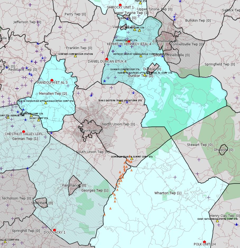
Click the map to enlarge
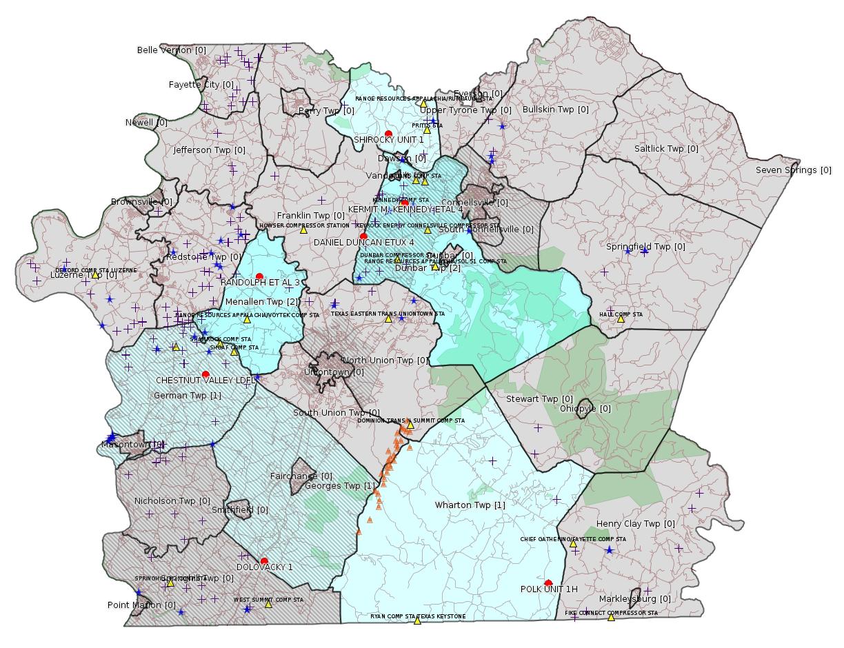
Map
Key
Red dots: items in this permit list with an exact location.
Blue stars: Marcellus Gas Well Water Sources.
Municipality shading: number of "facilities", with each well counting separately
(includes the red dots):
Red dots: items in this permit list with an exact location.
Blue stars: Marcellus Gas Well Water Sources.
Municipality shading: number of "facilities", with each well counting separately
(includes the red dots):
gray: 0
pale turquoise: 1
turquoise: 2
pale blue: 3
middle blue: 4
dark blue: 5
dark purple: 6
purple: 19
(Color coding may differ from one issue to the next.)
(Note if a project spans multiple municipalities -- e.g. a pipeline -- it will show in the count for each municipality.)
The number of facilities also follows the municipality name in brackets.
Municipality counts are based on the way the permit is listed by DEP; DEP has been known to get a municipality wrong.
Locations in brackets identify a precise location used to locate a surrogate for the actual site being permitted (e.g. locating a well pad or pipeline by the known location of a well.) Locations labeled beginning with "~" and ending in "[?]" are approximate and speculative based on inferences using on-line property and lease records. These are marked in the text as "[Approximate, Speculative]
Cross-hatching: Environmental Justice Areas
Yellow triangles: Compressor Stations
Orange triangles: Storage Field Wells (currently Dominion North Summit Storage Field)
Crosses: Unconventional well permits (may not have been drilled)
Green: "Natural areas", e.g. state game lands, state forests
Yellow triangles: Compressor Stations
Orange triangles: Storage Field Wells (currently Dominion North Summit Storage Field)
Crosses: Unconventional well permits (may not have been drilled)
Green: "Natural areas", e.g. state game lands, state forests
More Maps
 |
Source: Pennsylvania Bulletin
[Possibly off-topic:]
| Facility Location Municipality & County | Permit No. | Applicant Name & Address | Receiving Water/Use |
Contact Office & Phone No. |
|---|---|---|---|---|
| German Township Fayette County |
PAG036205 | Advanced Disposal Services 1184 McClellandtown Road McClellandtown, PA 15458 |
Unnamed Tributary to North Branch Browns Run—19-C WWF |
DEP Southwest Regional Office Clean Water Program 400 Waterfront Drive Pittsburgh, PA 15222-4745 412.442.4000 |
Draft Technical Guidance—Substantive Revision
DEP ID: 012-0900-001. Title: Policy for the Development and Publication of Technical Guidance. Description: This policy explains to the public and the regulated community the Department's process for developing TGDs. The purpose of this policy is to outline the Department's key considerations for the development of TGDs, tools available to enhance transparency in the TGD process, public comment periods, and the maintenance and distribution processes of TGDs. This draft TGD was significantly simplified from the previous version by removing internal direction and procedures for the Department's staff. The interim-final version published at 45 Pa.B. 2675 (May 30, 2015) is withdrawn with this notice.
Written Comments: Interested persons may submit written comments on this draft TGD by Wednesday, December 13, 2017. Comments submitted by facsimile will not be accepted. All comments must include the commentator's name and address. Commentators are encouraged to submit comments using the Department's eComment system at www.ahs.dep.pa.gov/eComment or by e-mail to ecomment@pa.gov. Written comments should be submitted to the Policy Office, Department of Environmental Protection, 400 Market Street, Harrisburg, PA 17101.
Contact: Questions regarding this action should be directed to Abbey Cadden at (717) 705-3769 or acadden@pa.gov.
Effective Date: Upon publication as final in the Pennsylvania Bulletin.
<http://www.pabulletin.com/secure/data/vol47/47-41/1696.html>
The actual document is available here:
<http://www.elibrary.dep.state.pa.us/dsweb/Get/Document-117243/012-0900-001.pdf>
---
Draft Technical Guidance—Substantive Revision
DEP ID: 012-0820-001. Title: Policy for the Development and Review of Regulations. Description: This policy explains the process the Department will follow to develop regulations necessary to effectively implement Commonwealth and Federal environmental laws for promulgation as appropriate, based on the expertise of the Department and other Commonwealth agency staff, Departmental advisory committees, boards and councils, and based on comments received during the public participation process. Several updates to this policy were necessary to ensure that it remains relevant to current practice. Also, updates were required to explain how amendments to the Regulatory Review Act (71 P.S. §§ 745.1—745.14) in 2012 impact how the Department carries out its regulatory review and development process.
Written Comments: Interested persons may submit written comments on this draft TGD by Wednesday, December 13, 2017. Comments submitted by facsimile will not be accepted. All comments must include the commentator's name and address. Commentators are encouraged to submit comments using the Department's eComment system at www.ahs.dep.pa.gov/eComment or by e-mail to ecomment@pa.gov. Written comments should be submitted to the Policy Office, Department of Environmental Protection, 400 Market Street, Harrisburg, PA 17101.
Contact: Questions regarding this action should be directed to Laura Edinger at (717) 772-3277 or ledinger@pa.gov.
Effective Date: Upon publication as final in the Pennsylvania Bulletin.
<http://www.pabulletin.com/secure/data/vol47/47-41/1696.html>
The actual document is available here:
<http://www.elibrary.dep.state.pa.us/dsweb/Get/Document-117242/012-0820-001.pdf>
---
Draft Technical Guidance—Substantive Revision
DEP ID: 012-1920-002. Title: Advisory Committee Guidelines. Description: These guidelines establish the role and function of the Department's advisory committees. New language was incorporated into the guidelines to clarify common areas of confusion for advisory committee members. These revisions are intended to clarify the roles of the Department, advisory committee members and the public when planning and holding advisory committee meetings.
Written Comments: Interested persons may submit written comments on this draft TGD by Wednesday, December 13, 2017. Comments submitted by facsimile will not be accepted. All comments must include the commentator's name and address. Commentators are encouraged to submit comments using the Department's eComment system at www.ahs.dep.pa.gov/eComment or by e-mail to ecomment@pa.gov. Written comments should be submitted to the Policy Office, Department of Environmental Protection, 400 Market Street, Harrisburg, PA 17101.
Contact: Questions regarding this action should be directed to Hayley Jeffords at (717) 772-3525 or hjeffords@pa.gov.
<http://www.pabulletin.com/secure/data/vol47/47-41/1696.html>
The actual document is available here:
<http://www.elibrary.dep.state.pa.us/dsweb/Get/Document-117244/012-1920-002.pdf>
-------------------------
Source: eNOTICE (+ PA Oil and Gas Mapping, Well Pad Report.) Well Details via Data Portal Services: Oil and Gas Wells All (ID: 3).
Please see the Disclaimer below regarding Parcel Id data.
[Conventional Well:]
Authorization ID: 1153264
Permit number: 051-23998
Site: DOLOVACKY 1 OG WELL
Client: ATLAS RESOURCES LLC
Authorization type: Well Plugging Notice Intent to Plug Single Well
Application type: New
Authorization is for: FACILITY
Date received: 09/15/2016
Status: Withdrawn on 10/9/2017
Permit Decision Guarantee Applies?: No
Sub-Facilities for Authorization:
Sub-Facility ID Sub-Facility Name Description
968705 DOLOVACKY 1 Well
Permit Review Notes:
Date Review Note
9/23/2016 The permit application package is complete, has been accepted, and is undergoing technical review.
<http://www.ahs.dep.pa.gov/eFACTSWeb/searchResults_singleAuth.aspx?AuthID=1153264>
Site Programs:
Oil & Gas
Municipalities:
Georges Twp [an Environmental Justice Area], Fayette County
Well Details:
Permit Number: 051-23998Map URL: <http://www.openstreetmap.org/?mlat=39.765064&mlon=-79.787708#map=15/39.765064/-79.787708>
Well Name: DOLOVACKY 1
Unconventional Well: N
Well Configuration: Vertical Well
Well Type: GAS
Well Status: Active
Coal Association: Coal
Conservation Well: N
Primary Facility ID: 706346
Site ID: 705679
Site Name: DOLOVACKY 1 OG WELL
Well Pad ID: 0
Well Pad Name:
Storage Field:
Operator: ATLAS RESOURCES LLC
Operator Number: OGO-66455
Permit Date: 2008-05-23
Permit Date Expires: 2009-05-23
SPUD Date: 2008-11-13
Date Plugged:
UIC ID:
UIC Type:
Surface Elevation: 1193
County: Fayette
Municipality: Georges Twp [an Environmental Justice Area]
Location: 39.765064,-79.787708
Presumed Parcel Id: 1440004104
[Conventional Well:]
Authorization ID: 1200214
Permit number: 051-20702
Site: KERMIT M KENNEDY ET AL 4 WELL
Client: XTO ENERGY INC
Authorization type: Drill & Operate Well Permit Inactive Status
Application type: New
Authorization is for: FACILITY
Date received: 08/29/2016
Status: Issued on 9/27/2017
Permit Decision Guarantee Applies?: No
Sub-Facilities for Authorization:
Sub-Facility ID Sub-Facility Name Description
56880 KERMIT M. KENNEDY ETAL 4 Well
Permit Review Notes:
Date Review Note
9/27/2017 The technical review and decision review are complete and either the permit decision and/or permit issuance are forthcoming.
9/27/2017 The permit application package is complete, has been accepted, and is undergoing technical review.
<http://www.ahs.dep.pa.gov/eFACTSWeb/searchResults_singleAuth.aspx?AuthID=1200214>
Site Programs:
Oil & Gas
Municipalities:
Dunbar Twp, Fayette County
Well Details:
Permit Number: 051-20702Map URL: <http://www.openstreetmap.org/?mlat=40.014648&mlon=-79.654565#map=15/40.014648/-79.654565>
Well Name: KERMIT M. KENNEDY ETAL 4
Unconventional Well: N
Well Configuration: Vertical Well
Well Type: GAS
Well Status: Active
Coal Association: Coal
Conservation Well: N
Primary Facility ID: 43350
Site ID: 41598
Site Name: KERMIT M KENNEDY ET AL 4 WELL
Well Pad ID: 0
Well Pad Name:
Storage Field:
Operator: XTO ENERGY INC
Operator Number: OGO-38958
Permit Date: 1993-07-30
Permit Date Expires: 1994-07-30
SPUD Date: 1994-05-31
Date Plugged:
UIC ID:
UIC Type:
Surface Elevation: 1210
County: Fayette
Municipality: Dunbar Twp
Location: 40.014648,-79.654565 [an Environmental Justice Area]
Presumed Parcel Id: 09110006
[Conventional Well:]
Authorization ID: 1200229
Permit number: 051-21017
Site: DANIEL DUNCAN ET UX 4 OG WELL
Client: XTO ENERGY INC
Authorization type: Drill & Operate Well Permit Inactive Status
Application type: New
Authorization is for: FACILITY
Date received: 12/14/2016
Status: Issued on 9/27/2017
Permit Decision Guarantee Applies?: No
Sub-Facilities for Authorization:
Sub-Facility ID Sub-Facility Name Description
400382 DANIEL DUNCAN ETUX 4 Well
Permit Review Notes:
Date Review Note
9/27/2017 The technical review and decision review are complete and either the permit decision and/or permit issuance are forthcoming.
9/27/2017 The permit application package is complete, has been accepted, and is undergoing technical review.
<http://www.ahs.dep.pa.gov/eFACTSWeb/searchResults_singleAuth.aspx?AuthID=1200229>
Site Programs:
Oil & Gas
Municipalities:
Dunbar Twp, Fayette County
Well Details:
Permit Number: 051-21017Map URL: <http://www.openstreetmap.org/?mlat=39.991844&mlon=-79.6932#map=15/39.991844/-79.6932>
Well Name: DANIEL DUNCAN ETUX 4
Unconventional Well: N
Well Configuration: Vertical Well
Well Type: GAS
Well Status: Regulatory Inactive Status
Coal Association: NonCoal
Conservation Well: N
Primary Facility ID: 518869
Site ID: 490525
Site Name: DANIEL DUNCAN ET UX 4 OG WELL
Well Pad ID: 0
Well Pad Name:
Storage Field:
Operator: XTO ENERGY INC
Operator Number: OGO-38958
Permit Date: 1998-08-03
Permit Date Expires: 1999-08-03
SPUD Date: 1998-09-17
Date Plugged:
UIC ID:
UIC Type:
Surface Elevation: 1195
County: Fayette
Municipality: Dunbar Twp
Location: 39.991844,-79.6932 [an Environmental Justice Area]
Presumed Parcel Id: 09200077
Authorization ID: 1201746
Permit number: 051-24428
Site: POLK 1H OG WELL
Client: LPR ENERGY LLC
Authorization type: Drill & Operate Well Permit Inactive Status
Application type: New
Authorization is for: FACILITY
Date received: 05/08/2017
Status: Issued on 10/6/2017
Permit Decision Guarantee Applies?: No
Sub-Facilities for Authorization:
Sub-Facility ID Sub-Facility Name Description
1035649 POLK UNIT 1H Well
1035648 POLK UNIT 1H Well
Permit Review Notes:
Date Review Note
10/6/2017 The technical review and decision review are complete and either the permit decision and/or permit issuance are forthcoming.
10/6/2017 The permit application package is complete, has been accepted, and is undergoing technical review.
<http://www.ahs.dep.pa.gov/eFACTSWeb/searchResults_singleAuth.aspx?AuthID=1201746>
Site Programs:
Oil & Gas
Municipalities:
Wharton Twp, Fayette County
Well Details:
Permit Number: 051-24428Map URL: <http://www.openstreetmap.org/?mlat=39.746494&mlon=-79.529567#map=15/39.746494/-79.529567>
Well Name: POLK UNIT 1H
Unconventional Well: Y
Well Configuration: Horizontal Well
Well Type: GAS
Well Status: Regulatory Inactive Status
Coal Association: NonCoal
Conservation Well: N
Primary Facility ID: 738671
Site ID: 739411
Site Name: POLK 1H OG WELL
Well Pad ID: 149075
Well Pad Name: POLK UNIT 1H
Storage Field:
Operator: LPR ENERGY LLC
Operator Number: OGO-68579
Permit Date: 2011-02-28
Permit Date Expires: 2012-02-28
SPUD Date: 2011-03-24
Date Plugged:
UIC ID:
UIC Type:
Surface Elevation: 2310
County: Fayette
Municipality: Wharton Twp
Location: 39.746494,-79.529567
Presumed Parcel Id: 4233000106
Authorization ID: 1201747
Permit number: GP05260717003
Site: RANDOLPH ET AL PIPELINE REPLACEMENT GP05
Client: RANGE RESOURCES APPALACHIA LLC
Authorization type: GP-05 Utility Line Stream Crossings
Application type: New
Authorization is for: FACILITY
Date received: 10/03/2017
Status: Pending
Permit Decision Guarantee Applies?: Yes
Permit Decision Guarantee status: VOID
Sub-Facilities for Authorization:
Sub-Facility ID Sub-Facility Name Description
1245321 RANDOLPH ET AL PIPELINE REPLACEMENT GP05 Pipeline or Conduit
<http://www.ahs.dep.pa.gov/eFACTSWeb/searchResults_singleAuth.aspx?AuthID=1201747>
Site Programs:
Water Planning and Conservation
Municipalities:
Menallen Twp, Fayette County
[Location is presumably given approximately by the location of RANDOLPH ET AL 3 below.]
[Possibly off-topic:]
Authorization ID: 1202153
Permit number: 100419
Site: CHESTNUT VALLEY LDFL
Client: ADVANCED DSPL SVC CHESTNUT VALLEY LDFL INC
Authorization type: Minor Modification to an Existing Fac
Application type: Modification
Authorization is for: FACILITY
Date received: 10/11/2017
Status: Pending
Permit Decision Guarantee Applies?: Yes
Permit Decision Guarantee status: ACTIVE
Sub-Facilities for Authorization:
Sub-Facility ID Sub-Facility Name Description
212043 J&J LANDFILL Landfill
<http://www.ahs.dep.pa.gov/eFACTSWeb/searchResults_singleAuth.aspx?AuthID=1202153>
Site Programs:
Air Quality
Clean Water
Environmental Cleanup & Brownfields
Mining
Radiation Protection
Waste Management
Water Planning and Conservation
Municipalities:
German Twp [an Environmental Justice Area], Fayette County
Location: 39.896765,-79.838766 <http://osm.org/go/ZWpP0~XK--?m=>
Presumed Parcel Id: 15280012
[Conventional Well:]
Authorization ID: 1202319
Permit number: 051-20829
Site: SHIROCKY UNIT 1 WELL
Client: RANGE RESOURCES APPALACHIA LLC
Authorization type: Drill & Operate Well Permit Inactive Status
Application type: New
Authorization is for: FACILITY
Date received: 10/11/2017
Status: Pending
Permit Decision Guarantee Applies?: No
Sub-Facilities for Authorization:
Sub-Facility ID Sub-Facility Name Description
259041 SHIROCKY UNIT 1 Well
<http://www.ahs.dep.pa.gov/eFACTSWeb/searchResults_singleAuth.aspx?AuthID=1202319>
Site Programs:
Oil & Gas
Municipalities:
Lower Tyrone Twp, Fayette County
Well Details:
Permit Number: 051-20829Map URL: <http://www.openstreetmap.org/?mlat=40.063551&mlon=-79.668781#map=15/40.063551/-79.668781>
Well Name: SHIROCKY UNIT 1
Unconventional Well: N
Well Configuration: Vertical Well
Well Type: GAS
Well Status: Active
Coal Association: Coal
Conservation Well: N
Primary Facility ID: 264326
Site ID: 253816
Site Name: SHIROCKY UNIT 1 WELL
Well Pad ID: 0
Well Pad Name:
Storage Field:
Operator: RANGE RESOURCES APPALACHIA LLC
Operator Number: OGO-60915
Permit Date: 1996-06-28
Permit Date Expires: 1997-06-28
SPUD Date: 1997-06-16
Date Plugged:
UIC ID:
UIC Type:
Surface Elevation: 1059
County: Fayette
Municipality: Lower Tyrone Twp
Location: 40.063551,-79.668781
Presumed Parcel Id: 18070019
[Conventional Well:]
Authorization ID: 1202324
Permit number: 051-21618
Site: RANDOLPH ET AL 3 OG WELL
Client: RANGE RESOURCES APPALACHIA LLC
Authorization type: Drill & Operate Well Permit Inactive Status
Application type: New
Authorization is for: FACILITY
Date received: 10/11/2017
Status: Pending
Permit Decision Guarantee Applies?: No
Sub-Facilities for Authorization:
Sub-Facility ID Sub-Facility Name Description
758003 RANDOLPH ET AL 3 Well
<http://www.ahs.dep.pa.gov/eFACTSWeb/searchResults_singleAuth.aspx?AuthID=1202324>
Site Programs:
Oil & Gas
Municipalities:
Menallen Twp, Fayette County
Well Details:
Permit Number: 051-21618Map URL: <http://www.openstreetmap.org/?mlat=39.964748&mlon=-79.788649#map=15/39.964748/-79.788649>
Well Name: RANDOLPH ET AL 3
Unconventional Well: N
Well Configuration: Vertical Well
Well Type: GAS
Well Status: Active
Coal Association: Coal
Conservation Well: N
Primary Facility ID: 631098
Site ID: 607330
Site Name: RANDOLPH ET AL 3 OG WELL
Well Pad ID: 0
Well Pad Name:
Storage Field:
Operator: RANGE RESOURCES APPALACHIA LLC
Operator Number: OGO-60915
Permit Date: 2002-12-06
Permit Date Expires: 2003-12-06
SPUD Date: 2002-12-11
Date Plugged:
UIC ID:
UIC Type:
Surface Elevation: 1035
County: Fayette
Municipality: Menallen Twp
Location: 39.964748,-79.788649
Presumed Parcel Id: 22060031
-------------------------
Source: Reuters Commodities: Energy
Natural Gas
| Commodity | Exchange | Currency | Expire | Last Trade | Trade Time | Change | Open | Day's High | Day's Low |
|---|---|---|---|---|---|---|---|---|---|
| NATURAL
GAS CON1 Oct17 |
NYM | USD | 10/27 | 2.97 | 10/16 01:00 | -0.03 | 2.96 | 2.98 | 2.96 |
<http://www.reuters.com/finance/commodities/energy>
-------------------------
Notes:
[None]
------------------------
DEP defines an environmental justice area as "any census tract where 20 percent or more individuals live in poverty, and/or 30 percent or more of the population is minority". (See:
<http://www.dep.pa.gov/PublicParticipation/OfficeofEnvironmentalJustice/Pages/default.aspx>). There are supposed to be enhanced public participation requirements for permits in environmental justice areas, but news of this actually ever happening is scarce. In Fayette County, the entirety of Springhill, Nicholson, German, and Georges Townships are environmental justice areas, as well as a large part of Dunbar Township. DEP's policy document on public participation guidelines for environmental justice areas is located here:
<http://www.elibrary.dep.state.pa.us/dsweb/Get/Version-48671/012-0501-002.pdf>
eNOTICE records are likely to list the same permit multiple times, as that permit moves through the DEP process.
Oil & Gas Wells designated with a site a number and the letter H typically designate horizontal wells.
-------------------------
Resources:
Pennsylvania Bulletin: <http://www.pabulletin.com/>
eNOTICE: <http://www.ahs2.dep.state.pa.
DEP Oil and Gas Reports: <http://www.dep.pa.gov/DataandTools/Reports/Oil%20and%20Gas%20Reports/Pages/default.aspx>
DEP Well Details Report: <https://www.paoilandgasreport
Well Details may not show any
information for new permits and will not show permits which have
not yet been issued. Lookup for Well Details is by permit number.
DEP Permits Issued Detail Report:
<http://www.depreportingservic
DEP SPUD (drilling started) Report:
<http://www.depreportingservices.state.pa.us/ReportServer/Pages/ReportViewer.aspx?/Oil_Gas/Spud_External_Data>
DEP Oil and Gas Compliance Report:
<http://www.depreportingservices.state.pa.us/ReportServer/Pages/ReportViewer.aspx?/Oil_Gas/OG_Compliance>
DEP PA Oil & Gas Mapping:
<http://www.depgis.state.pa.us/PaOilAndGasMapping>
Data Portal Services Directory [Technical]
<http://www.depgis.state.pa.us/arcgis/rest/services>
Query: Oil and Gas Wells All (ID: 3) [Technical]:
<http://www.depgis.state.pa.us/arcgis/rest/services/OilGas/OilGasAllStrayGas/MapServer/3/query?where=&text=&objectIds=&time=&geometry=&geometryType=esriGeometryEnvelope&inSR=&spatialRel=esriSpatialRelIntersects&relationParam=&outFields=OBJECTID%2CPERMIT_NUMBER%2CWELL_NAME%2COPERATOR%2COPERATOR_NUMBER%2CWELL_TYPE%2CWELL_TYPE_CODE%2CWELL_STATUS%2CWELL_STATUS_CODE%2CPERMIT_DATE%2CPERMIT_DATE_EXPIRES%2CSPUD_DATE%2CCONSERVATION_IND%2CCOUNTY%2CCOUNTY_ID%2CMUNICIPALITY%2CMUNICIPALITY_TYPE%2CMUNICIPALITY_CODE%2CLATITUDE%2CLONGITUDE%2CPRMRY_FID%2CUNCONVENTIONAL_IND%2CSURFACE_ELEVATION%2CWELL_CONFIG_CODE%2CCOAL_IND%2CWELL_PAD_NAME%2CSHAPE%2CDATE_PLUGGED%2CWELL_PAD_ID%2CUIC_ID%2CUIC_TYPE_DESCRIPTION%2CSTORAGE_FIELD_NAME%2CSITE_ID%2CSITE_NAME&returnGeometry=true&returnTrueCurves=false&maxAllowableOffset=&geometryPrecision=&outSR=&returnIdsOnly=false&returnCountOnly=false&orderByFields=&groupByFieldsForStatistics=&outStatistics=&returnZ=false&returnM=false&gdbVersion=&returnDistinctValues=false&resultOffset=&resultRecordCount=&f=html>
(Be sure to enter a Where clause in SQL format. Dates are in milliseconds since midnight 1/1/1970).
DEP Oil and Gas Electronic Notifications
<http://www.depreportingservices.state.pa.us/ReportServer?/Oil_Gas/OG_Notifications>
DEP Oil and Gas Well Pad Report
<http://www.depreportingservices.state.pa.us/ReportServer?/Oil_Gas/Well_Pads>
Fayette County Assessment Office Search For Tax Records:
<http://property.co.fayette.pa.us/search.aspx>
Pennsylvania Spatial Data Access:
<http://www.pasda.psu.edu/default.asp>
DEP Spatial Data Repository:
<ftp://www.pasda.psu.edu/pub/pasda/dep/>
National Response Center:
<http://www.nrc.uscg.mil/>
EPA-Echo: <http://www.epa-echo.gov/echo/
FERC citizen involvement: <http://www.ferc.gov/for-citiz
To receive E-mail notification of
all documents filed in a FERC docket, see:
<http://www.ferc.gov/docs-filing/esubscription.asp >
<http://www.ferc.gov/docs-fili
Follow the directions and enter the docket number to subscribe to.
Township Supervisors receive information regarding Erosion & Sedimentation permits, and these records may be reviewable at township municipal offices.
DEP permits are reviewable through the File Review process, for application to do file review see: <http://www.portal.state.pa.us/portal/server.pt/community/southwest_regional_office/13775/file_review/593164>
Environmental Hearing Board: <http://ehb.courtapps.com/publ
PA DEP Environmental Policy Comment System:
<http://www.ahs.dep.pa.gov/eComment/>
Federal Register Environment: <https://www.federalregister.g
Browsing of recent comment
opportunities for federal agencies, e.g. EPA. Click "sign up" to
subscribe to daily E-mails of new document listings.
SkyTruth Fayette County Drilling Alerts: <http://frack.skytruth.org/pen
U.S. Army Corps of Engineers, Pittsburgh District, Public Notices:
<http://www.lrp.usace.army.mil/Missions/Regulatory/Public-Notices/>
EPA Pennsylvania Public Notices: <http://www2.epa.gov/aboutepa/epa-pennsylvania#notice>
Marcellus Shale waste disposal
injection wells in Pennsylvania are regulated directly by EPA, not
DEP. Notice of any new permit applications will appear at the
above web address. I'm not aware of any subscription service
to be notified of such applications. I'm not aware of any
Marcellus Shale waste disposal injection wells in Fayette County
(yet ...) but we need to monitor this page for future
applications.
Energy Assurance Daily: <http://www.oe.netl.doe.gov/ead.aspx>
Daily newsletter from the US
Department of Energy about events relating to energy. The Natural
Gas section has information about pipelines.
-------------------------
Disclaimers:
This compilation from the above sources was done by hand using copy and paste and may omit relevant permits.
Parcel data is provided via the tax records search web page offered by the Fayette County Assessment Office (http://property.co.fayette.pa.us/). Presumed Parcel Id links are subject to availability provided by that agency and associated web sites. Presumed Parcel Ids are determined as the mapped parcel containing a given latitude and longitude, are a best effort determination which is subject to error, and are not official. In cases where a facility is leased and there is a separate parcel id for the lease, if this parcel id is not separately mapped, the parcel id shown will be the id for the enclosing parcel. Parcel owners may be surface owners only and may or may not have any relationship to oil & gas facilities.
Does not currently include water supply permits. Does not include landfill permits even though many such are for Marcellus Shale waste. (It is not possible at this time to distinguish which landfill permits are for Marcellus Shale waste and which are not without doing File Review for each permit.)
Erosion & Sedimentation permit records do not currently include latitude and longitude. Where I am publishing latitude and longitude with E&S permits it is by inferring an associated well permit and using published latitude and longitude for the well. It is possible I may be inferring the wrong well site.
Municipalities are shown from eFACTS records on the DEP web site. The DEP has been known to list a municipality incorrectly.