The Harmed Success Stories Concepts How To What Is Commentary
Fayette County Marcellus Shale Permits 10/5/15 - 10/18/15
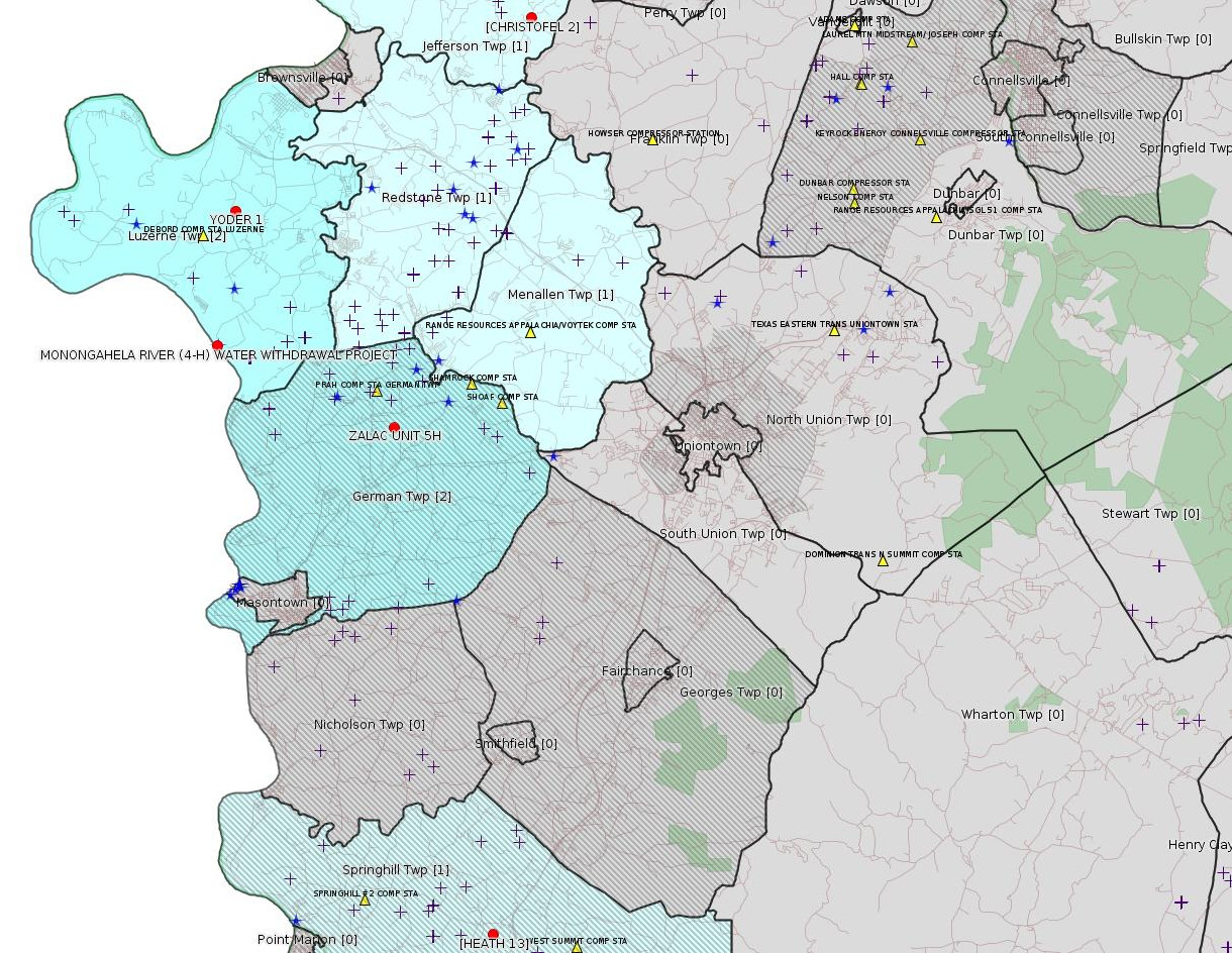
Click the map to enlarge

Map
Key
Red dots: items in this permit list with an exact location.
Blue stars: Marcellus Gas Well Water Sources.
Municipality shading: number of "facilities", with each well counting separately
(includes the red dots):
Red dots: items in this permit list with an exact location.
Blue stars: Marcellus Gas Well Water Sources.
Municipality shading: number of "facilities", with each well counting separately
(includes the red dots):
gray: 0
pale turquoise: 1
turquoise: 2
pale blue: 3
middle blue: 4
dark blue: 7
dark purple: 11
purple: 19
(Color coding may differ from one issue to the next.)
(Note if a project spans multiple municipalities -- e.g. a pipeline -- it will show in the count for each municipality.)
The number of facilities also follows the municipality name in brackets.
Municipality counts are based on the way the permit is listed by DEP; DEP has been known to get a municipality wrong.
Locations in brackets identify a precise location used to locate a surrogate for the actual site being permitted (e.g. locating a well pad or pipeline by the known location of a well.) Locations labeled beginning with "~" and ending in "[?]" are approximate and speculative based on inferences using on-line property and lease records. These are marked in the text as "[Approximate, Speculative]
Cross-hatching: Environmental Justice Areas
Yellow triangles: Compressor Stations
Crosses: Unconventional well permits (may not have been drilled)
Green: "Natural areas", e.g. state game lands, state forests
Yellow triangles: Compressor Stations
Crosses: Unconventional well permits (may not have been drilled)
Green: "Natural areas", e.g. state game lands, state forests
More Maps
 |
Source: Pennsylvania Bulletin
[No Activity]
-------------------------
Source: eNOTICE (+ PA Oil and Gas Mapping)
Authorization ID: 1085017
Permit number: ESX12-051-0007
Site: CHRISTOFEL WELL CONNECT ESCGP-EXPEDITED
Client: LAUREL MTN MIDSTREAM OPR LLC
Authorization type: Expedited E&S Stormwater General Permit 1
Application type: Notification
Authorization is for: SITE
Date received: 08/12/2015
Status: Pending
<http://www.ahs.dep.pa.gov/eFACTSWeb/searchResults_singleAuth.aspx?AuthID=1085017>
Location [of CHRISTOFEL 2 (surrogate)]: 40.037386,-79.797899 <http://osm.org/go/ZWp1Aw7k--?m=>
Municipalities: Jefferson Twp
Authorization ID: 1085018
Permit number: ESX11-051-0033
Site: HEATH WELL CONNECT ESCGP-EXPEDITED
Client: LAUREL MTN MIDSTREAM OPR LLC
Authorization type: Expedited E&S Stormwater General Permit 1
Application type: Notification
Authorization is for: SITE
Date received: 08/12/2015
Status: Pending
<http://www.ahs.dep.pa.gov/eFACTSWeb/searchResults_singleAuth.aspx?AuthID=1085018>
Location [of HEATH 13 (surrogate)]: 39.739447,-79.819220 <http://osm.org/go/ZWpKsmeI--?m=>
Municipalities: Springhill Twp [an Environmental Justice Area]
Authorization ID: 1085249
Permit number: GP04260715001
Site: MONONGAHELA RIVER (4-H) WATER WITHDRAWAL PROJECT GP4
Client: CHEVRON APPALACHIA LLC
Authorization type: GP-04 Intake & Outfall Structures
Application type: New
Authorization is for: FACILITY
Date received: 07/23/2015
Status: Pending
Sub-Facility ID Sub-Facility Name Description
1183139 MONONGAHELA RIVER (4-H) WATER WITHDRAWAL PROJECT GP4 Intake Structure
<http://www.ahs.dep.pa.gov/eFACTSWeb/searchResults_singleAuth.aspx?AuthID=1085249>
Location: 39.931997,-79.932245 <http://osm.org/go/ZWpYxPCq--?m=>
Municipalities: Luzerne Twp
Authorization ID: 1077080
Permit number: ESX10-051-0039
Site: NORTH PIPELINE PROJECT ESCGP-EXPEDITED
Client: LAUREL MTN MIDSTREAM OPR LLC
Authorization type: Expedited E&S Stormwater General Permit 1
Application type: Notification
Authorization is for: SITE
Date received: 06/11/2015
Status: Pending
<http://www.ahs.dep.pa.gov/eFACTSWeb/searchResults_singleAuth.aspx?AuthID=1077080>
Municipalities: German Twp [an Environmental Justice Area], Menallen Twp, Redstone Twp
Authorization ID: 1089542
Permit number: 051-24635
Site: YODER WELL PAD ESCGP-2 EXPEDITED
Client: CHEVRON APPALACHIA LLC
Authorization type: Drill & Operate Well Permit
Application type: New
Authorization is for: FACILITY
Date received: 09/14/2015
Status: Pending [Actually Issued 10/16/2015? -See Notes. -jr]
Sub-Facility ID Sub-Facility Name Description
1186051 YODER 1 Well
<http://www.ahs.dep.pa.gov/eFACTSWeb/searchResults_singleAuth.aspx?AuthID=1089542>
Conservation Well: N
Well Configuration: Vertical Well
Location: 39.975683,-79.923763 <http://osm.org/go/ZWpZzGbq--?m=>
Municipalities: Luzerne Twp
Full Permit:
<http://www.depgis.state.pa.us/PaOilAndGasMapping/PdFFetcher.ashx?Doc=xoTKsgMc2OcAAYSta5c4WA%3d%3d&ext=PDF>
-------------------------
Source: DEP Oil and Gas Compliance Report
OPERATOR: CHEVRON APPALACHIA LLC
INSPECTION_ID: 2416027
INSPECTION_DATE: 09/28/2015
INSPECTION_TYPE: Incident- Response to Accident or Event
API_PERMIT: 051-24622
FARM_NAME: ZALAC UNIT 5H
UNCONVENTIONAL: Y
SITE_ID: 786409
SITE_NAME: ZALAC UNIT #5-11H WELL SITE ESCGP-2 EXPEDITED
FACILITY_TYPE: Oil & Gas Location
INSPECTION_CATEGORY: Primary Facility
REGION: EP DOGO SWDO Dstr Off
COUNTY: Fayette
MUNICIPALITY: German Twp
INSPECTION_RESULT_DESCRIPTION: In Compliance with Policy
INSPECTION_COMMENT: "On 9/28/15, I inspected the Zalac site in response to a spill reported on 9/20/15 by the operator and made the following observations:
•The operator initially reported a spill of 50-100 gallons of synthetic based mud with approximately half of the spill spraying off of containment with no contamination to waterways.
•A secondary report from the operator reduced the estimated amount that escaped containment to 15 gallons.
•At the time of inspection contaminated soil and vegetation had been removed and temporary stabilization was in place on the site; contaminated materials were placed in a 55 gallon drum and dumpsters prior to inspection.
oThe area cleared of contaminated materials was filled in and stabilized at the time of inspection.
•At the time of inspection pad containment was nearly overtopped with water, the site supervisor noted that vac trucks were scheduled to remove the water the next morning."
Location: 39.904511,-79.858119 <http://osm.org/go/ZWpaKHBm--?m=>
[There is a similar report for each well on the same pad.]
-------------------------
Source: Reuters Commodities: Energy
Natural Gas
| Commodity | Exchange | Currency | Expire | Last Trade | Trade Time | Change | Open | Day's High | Day's Low |
|---|---|---|---|---|---|---|---|---|---|
| NATURAL
GAS CON1 Oct15 |
NYM | USD | 10/28 | 2.45 | 10/17 21:43 | +0.02 | 2.46 | 2.48 | 2.45 |
-------------------------
Notes:
As above, eFACTS shows as of Sunday afternoon, 10/18/2015, that status for the Yoder 1 well application, authorization id 1089542, is Pending. However, the record on PA Oil & Gas Mapping for this well shows Issued 10/16/2015. Attempting to pull the Permits Issued Detail report for start and end 10/16/2015 for Fayette County produces an error message, so presumably there is something faulty here in the data entry. The full permit has been normally available on PA Oil & Gas Mapping only for permits that have been issued. So One assumes that the correct status for this well should be Issued 10/16/2015 and not the way eFACTS shows it.
------------------------
DEP defines an environmental justice area as "any census tract where 20 percent or more individuals live in poverty, and/or 30 percent or more of the population is minority". (See:
<http://www.portal.state.pa.us/portal/server.pt/community/pa_environmental_justice_areas/20991>
<http://www.portal.state.pa.us/portal/server.pt/community/dep_enhanced_public_participation_policy/20988>
). There are supposed to be enhanced public participation requirements for permits in environmental justice areas, but news of this actually ever happening is scarce. In Fayette County, the entirety of Springhill, Nicholson, German, and Georges Townships are environmental justice areas, as well as a large part of Dunbar Township. DEP's policy document on public participation guidelines for environmental justice areas is located here:
<http://www.elibrary.dep.state.pa.us/dsweb/Get/Version-48671/012-0501-002.pdf>
eNOTICE records are likely to list the same permit multiple times, as that permit moves through the DEP process.
Oil & Gas Wells designated with a site a number and the letter H typically designate horizontal wells.
The eMapPa web site does not work in web browsers other than Internet Explorer. For instructions on how to view eMapPa data in Firefox send me E-mail.
-------------------------
Resources:
Pennsylvania Bulletin: <http://www.pabulletin.com/>
eNOTICE: <http://www.ahs2.dep.state.pa.
DEP Well Details Report: <https://www.paoilandgasreport
Well Details may not show any
information for new permits and will not show permits which have
not yet been issued. Lookup for Well Details is by permit number.
DEP Permits Issued Detail Report:
<http://www.depreportingservic
DEP SPUD (drilling started) Report:
<http://www.depreportingservices.state.pa.us/ReportServer/Pages/ReportViewer.aspx?/Oil_Gas/Spud_External_Data>
DEP Oil and Gas Compliance Report:
<http://www.depreportingservices.state.pa.us/ReportServer/Pages/ReportViewer.aspx?/Oil_Gas/OG_Compliance>
DEP PA Oil & Gas Mapping:
<http://www.depgis.state.pa.us/PaOilAndGasMapping>
Pennsylvania Spatial Data Access:
<http://www.pasda.psu.edu/default.asp>
DEP Spatial Data Repository:
<ftp://www.pasda.psu.edu/pub/pasda/dep/>
National Response Center:
<http://www.nrc.uscg.mil/>
EPA-Echo: <http://www.epa-echo.gov/echo/
FERC citizen involvement: <http://www.ferc.gov/for-citiz
To receive E-mail notification of
all documents filed in a FERC docket, see:
<http://www.ferc.gov/docs-filing/esubscription.asp >
<http://www.ferc.gov/docs-fili
Follow the directions and enter the docket number to subscribe to.
Township Supervisors receive information regarding Erosion & Sedimentation permits, and these records may be reviewable at township municipal offices.
DEP permits are reviewable through the File Review process, for application to do file review see: <http://www.portal.state.pa.us/portal/server.pt/community/southwest_regional_office/13775/file_review/593164>
Environmental Hearing Board: <http://ehb.courtapps.com/publ
PA DEP Environmental Policy Comment System:
<http://www.ahs.dep.pa.gov/eComment/>
Federal Register Environment: <https://www.federalregister.g
Browsing of recent comment
opportunities for federal agencies, e.g. EPA. Click "sign up" to
subscribe to daily E-mails of new document listings.
SkyTruth Fayette County Drilling Alerts: <http://frack.skytruth.org/pen
EPA Region 3 Water Protection Public Notices: <http://www.epa.gov/reg3wapd/p
Marcellus Shale waste disposal
injection wells in Pennsylvania are regulated directly by EPA, not
DEP. Notice of any new permit applications will appear at the
above web address. I'm not aware of any subscription service
to be notified of such applications. I'm not aware of any
Marcellus Shale waste disposal injection wells in Fayette County
(yet ...) but we need to monitor this page for future
applications.
Energy Assurance Daily: <http://www.oe.netl.doe.gov/ead.aspx>
Daily newsletter from the US
Department of Energy about events relating to energy. The Natural
Gas section has information about pipelines.
-------------------------
Disclaimers:
This compilation from the above sources was done by hand using copy and paste and may omit relevant permits.
Does not currently include water supply permits. Does not include landfill permits even though many such are for Marcellus Shale waste. (It is not possible at this time to distinguish which landfill permits are for Marcellus Shale waste and which are not without doing File Review for each permit.)
Erosion & Sedimentation permit records do not currently include latitude and longitude. Where I am publishing latitude and longitude with E&S permits it is by inferring an associated well permit and using published latitude and longitude for the well. It is possible I may be inferring the wrong well site.
Municipalities are shown from eFACTS records on the DEP web site. The DEP has been known to list a municipality incorrectly.