The Harmed Success Stories Concepts How To What Is Commentary
Fayette County Marcellus Shale Permits 10/17/16 - 10/30/16
Click the map to enlarge
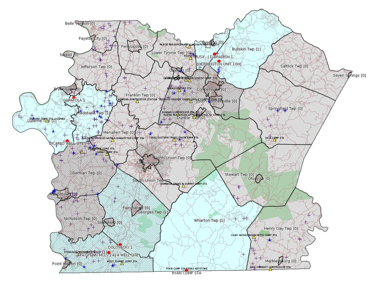
Map
Key
Red dots: items in this permit list with an exact location.
Blue stars: Marcellus Gas Well Water Sources.
Municipality shading: number of "facilities", with each well counting separately
(includes the red dots):
Red dots: items in this permit list with an exact location.
Blue stars: Marcellus Gas Well Water Sources.
Municipality shading: number of "facilities", with each well counting separately
(includes the red dots):
gray: 0
pale turquoise: 1
turquoise: 2
pale blue: 3
middle blue: 4
dark blue: 6
dark purple: 9
purple: 19
(Color coding may differ from one issue to the next.)
(Note if a project spans multiple municipalities -- e.g. a pipeline -- it will show in the count for each municipality.)
The number of facilities also follows the municipality name in brackets.
Municipality counts are based on the way the permit is listed by DEP; DEP has been known to get a municipality wrong.
Locations in brackets identify a precise location used to locate a surrogate for the actual site being permitted (e.g. locating a well pad or pipeline by the known location of a well.) Locations labeled beginning with "~" and ending in "[?]" are approximate and speculative based on inferences using on-line property and lease records. These are marked in the text as "[Approximate, Speculative]
Cross-hatching: Environmental Justice Areas
Yellow triangles: Compressor Stations
Crosses: Unconventional well permits (may not have been drilled)
Green: "Natural areas", e.g. state game lands, state forests
Yellow triangles: Compressor Stations
Crosses: Unconventional well permits (may not have been drilled)
Green: "Natural areas", e.g. state game lands, state forests
More Maps
 |
Source: Pennsylvania Bulletin
ESCGP-2 # ESX11-051-0034
Applicant Name Chevron Appalachia, LLC
Contact Person Branden Weimer
Address 800 Mountain View Drive
City, State, Zip Smithfield, PA 15478
County Fayette County
Township(s) Luzerne Township
Receiving Stream(s) and Classification(s) Wallace Run, UNT to Wallace Run, UNT to Lily Run/Middle Monongahela River (WWF)
<http://www.pabulletin.com/secure/data/vol46/46-43/1813c.html>
Site: DICARLO WELL SITES ESCGP-EXPEDITED
Location: 39.934281,-79.895722 <http://osm.org/go/ZWpY72yi--?m=>
Presumed Parcel ID: 19340017
Well Pad ID: 148231
Well Pad Name: DICARLO UNIT 13H
Well Pad Site ID: 752636
Wells on this pad:
051-24472 DICARLO UNIT 13H
051-24473 DICARLO UNIT 14H
051-24474 DICARLO UNIT 15H
051-24475 DICARLO UNIT 16H
051-24476 DICARLO UNIT 17H
051-24477 DICARLO UNIT 18H
[See Notes from the 10/2/16 issue of this bulletin]
RULES AND REGULATIONS
Title 25—ENVIRONMENTAL PROTECTION
ENVIRONMENTAL QUALITY BOARD
[ 25 PA. CODE CH. 78a ]
Environmental Protection Performance Standards at Oil and Gas Well Sites; Correction
[46 Pa.B. 6829]
[Saturday, October 29, 2016]
An error occurred in the final-form rulemaking published at 46 Pa.B. 6431, 6484 (October 8, 2016). In subparagraph (i) of the definition of ''well development pipelines'' in § 78a.1 (relating to definitions), ''; and,'' was inadvertently deleted.
The correct version of the definition of ''well development pipelines'' in § 78a.1 appears in Annex A, with ellipses referring to the existing text of the regulations.
Annex A
TITLE 25. ENVIRONMENTAL PROTECTION
PART I. DEPARTMENT OF ENVIRONMENTAL PROTECTION
Subpart C. PROTECTION OF NATURAL RESOURCES
ARTICLE I. LAND RESOURCES
CHAPTER 78a. UNCONVENTIONAL WELLS
Subchapter A. GENERAL PROVISIONS
§ 78a.1. Definitions.
The following words and terms, when used in this chapter, have the following meanings, unless the context clearly indicates otherwise, or as otherwise provided in this chapter:
* * * * *
Well development pipelines—Pipelines used for oil and gas operations that:
(i) Transport materials used for the drilling or hydraulic fracture stimulation, or both, of a well and the residual waste generated as a result of the activities; and,
(ii) Lose functionality after the well site it serviced has been restored under § 78a.65 (related to site restoration).
* * * * *
<http://www.pabulletin.com/secure/data/vol46/46-44/1859.html>
-------------------------
Source: eNOTICE (+ PA Oil and Gas Mapping, Well Pad Report) Please see the Disclaimer below regarding Parcel Id data.
Authorization ID: 1129399
Permit number: GP5-26-00572C
Site: RYAN COMP STA/TEXAS KEYSTONE
Client: DIVERSIFIED OIL & GAS LLC
Authorization type: AQ General Permit
Application type: New
Authorization is for: FACILITY
Date received: 02/17/2016
Status: Withdrawn on 10/17/2016
<http://www.ahs.dep.pa.gov/eFACTSWeb/searchResults_singleAuth.aspx?AuthID=1129399>
Location: 39.721949,-79.649167 <http://osm.org/go/ZWo39DCv--?m=>
Presumed Parcel Id: 42360001
Municipalities: Wharton Twp
Authorization ID: 1156372
Permit number: ESX12-051-0005
Site: HERRINGTON UNIT 16H-20H ESCGP-EXPEDITED
Client: CHEVRON APPALACHIA LLC
Authorization type: Expedited E&S Stormwater General Permit 1
Application type: Notification
Authorization is for: SITE
Date received: 08/02/2016
Status: Issued on 10/21/2016
<http://www.ahs.dep.pa.gov/eFACTSWeb/searchResults_singleAuth.aspx?AuthID=1156372>
Location [of HERRINGTON UNIT 16H (surrogate):] 40.060144,-79.574089 <http://osm.org/go/ZWp9w7_Y--?m=>
Municipalities: Bullskin Twp
Presumed Parcel Id: 04280072
[See Notes.]
Authorization ID: 1156762
Permit number: ESX13-051-0003
Site: FAY-PENN MCLS 1414 WELL SITE ESCGP2 - EXPEDITED
Client: CHEVRON APPALACHIA LLC
Authorization type: Expedited E&S Stormwater General Permit 1
Application type: Notification
Authorization is for: SITE
Date received: 06/30/2016
Status: Pending
<http://www.ahs.dep.pa.gov/eFACTSWeb/searchResults_singleAuth.aspx?AuthID=1156762>
Location: 39.752572,-79.811431 <http://osm.org/go/ZWpK6bVi--?m=>
Municipalities: Springhill Twp [an Environmental Justice Area]
Presumed Parcel Id: 36080081
Wells on this pad:
051-24583 FAY-PENN UNIT 46H
051-24584 FAY-PENN UNIT 47H
051-24585 FAY-PENN UNIT 48H
[See Notes.]
[Conventional Well:]
Authorization ID: 1153264
Permit number: 051-23998
Site: DOLOVACKY 1 OG WELL
Client: ATLAS RESOURCES LLC
Authorization type: Well Plugging Notice Intent to Plug Single Well
Application type: New
Authorization is for: FACILITY
Date received: 09/15/2016
Status: Pending
Sub-Facility ID Sub-Facility Name Description
968705 DOLOVACKY 1 Well
<http://www.ahs.dep.pa.gov/eFACTSWeb/searchResults_singleAuth.aspx?AuthID=1153264>
Location: 39.765064,-79.787708 <http://osm.org/go/ZWpgXgI6--?m=>
Municipalities: Georges Twp [an Environmental Justice Area]
Presumed Parcel Id: 1440004104
[Conventional Well:]
Authorization ID: 1153337
Permit number: 051-21193
Site: USX J D BRADISH 1 OG WELL
Client: KEYROCK ENERGY LLC
Authorization type: Well Plugging Notice Intent to Plug Single Well
Application type: New
Authorization is for: FACILITY
Date received: 09/21/2016
Status: Pending
Sub-Facility ID Sub-Facility Name Description
523611 USX - J D BRADISH 1 Well
Permit Review Notes:
Date Review Note
9/28/2016 Applicant has been issued a deficiency letter. If applicable, this application no longer qualifies for the Permit Decision Guarantee.
<http://www.ahs.dep.pa.gov/eFACTSWeb/searchResults_singleAuth.aspx?AuthID=1153337>
Location: 40.071913,-79.58292 <http://osm.org/go/ZWp90Wf7--?m=>
Municipalities: Upper Tyrone Twp
Presumed Parcel Id: 39140011
[Conventional Well:]
Authorization ID: 1153348
Permit number: 051-21230
Site: GARAFOLA 1 OG WELL
Client: KEYROCK ENERGY LLC
Authorization type: Well Plugging Notice Intent to Plug Single Well
Application type: New
Authorization is for: FACILITY
Date received: 09/21/2016
Status: Pending
Sub-Facility ID Sub-Facility Name Description
533284 GARAFOLA 1 Well
<http://www.ahs.dep.pa.gov/eFACTSWeb/searchResults_singleAuth.aspx?AuthID=1153348>
Location: 40.004581,-79.880819 <http://osm.org/go/ZWpeGQ1h--?m=>
Municipalities: Redstone Twp
Presumed Parcel Id: 30040220
-------------------------
Source: Reuters Commodities: Energy
Natural Gas
| Commodity | Exchange | Currency | Expire | Last Trade | Trade Time | Change | Open | Day's High | Day's Low |
|---|---|---|---|---|---|---|---|---|---|
| NATURAL
GAS CON1 Nov16 |
NYM | USD | 11/28 | 3.13 | 10/29 23:00 | +0.03 | 3.15 | 3.15 | 3.13 |
-------------------------
Notes:
The authorization record above for HERRINGTON UNIT 16H-20H ESCGP-EXPEDITED appears to duplicate authorization 1152103,
<http://www.ahs.dep.pa.gov/eFACTSWeb/searchResults_singleAuth.aspx?AuthID=1152103>, (issued 9/15/2016), which is for the same permit and is indicated as having the same received date. As noted in the 10/2/16 issue of this bulletin, all of the wells Herrington Unit 16H-20H are shown as "Proposed But Never Materialized" in a DEP Facility Search for "Herrington", program Oil & Gas, county Fayette.
---
Evidently none of the wells at the FAY-PENN MCLS 1414 WELL SITE was ever in production.
------------------------
DEP defines an environmental justice area as "any census tract where 20 percent or more individuals live in poverty, and/or 30 percent or more of the population is minority". (See:
<http://www.portal.state.pa.us/portal/server.pt/community/pa_environmental_justice_areas/20991>
<http://www.portal.state.pa.us/portal/server.pt/community/dep_enhanced_public_participation_policy/20988>
). There are supposed to be enhanced public participation requirements for permits in environmental justice areas, but news of this actually ever happening is scarce. In Fayette County, the entirety of Springhill, Nicholson, German, and Georges Townships are environmental justice areas, as well as a large part of Dunbar Township. DEP's policy document on public participation guidelines for environmental justice areas is located here:
<http://www.elibrary.dep.state.pa.us/dsweb/Get/Version-48671/012-0501-002.pdf>
eNOTICE records are likely to list the same permit multiple times, as that permit moves through the DEP process.
Oil & Gas Wells designated with a site a number and the letter H typically designate horizontal wells.
-------------------------
Resources:
Pennsylvania Bulletin: <http://www.pabulletin.com/>
eNOTICE: <http://www.ahs2.dep.state.pa.
DEP Well Details Report: <https://www.paoilandgasreport
Well Details may not show any
information for new permits and will not show permits which have
not yet been issued. Lookup for Well Details is by permit number.
DEP Permits Issued Detail Report:
<http://www.depreportingservic
DEP SPUD (drilling started) Report:
<http://www.depreportingservices.state.pa.us/ReportServer/Pages/ReportViewer.aspx?/Oil_Gas/Spud_External_Data>
DEP Oil and Gas Compliance Report:
<http://www.depreportingservices.state.pa.us/ReportServer/Pages/ReportViewer.aspx?/Oil_Gas/OG_Compliance>
DEP PA Oil & Gas Mapping:
<http://www.depgis.state.pa.us/PaOilAndGasMapping>
DEP Oil and Gas Electronic Notifications
<http://www.depreportingservices.state.pa.us/ReportServer?/Oil_Gas/OG_Notifications>
DEP Oil and Gas Well Pad Report
<http://www.depreportingservices.state.pa.us/ReportServer?/Oil_Gas/Well_Pads>
Fayette County Assessment Office Search For Tax Records:
<http://property.co.fayette.pa.us/search.aspx>
Pennsylvania Spatial Data Access:
<http://www.pasda.psu.edu/default.asp>
DEP Spatial Data Repository:
<ftp://www.pasda.psu.edu/pub/pasda/dep/>
National Response Center:
<http://www.nrc.uscg.mil/>
EPA-Echo: <http://www.epa-echo.gov/echo/
FERC citizen involvement: <http://www.ferc.gov/for-citiz
To receive E-mail notification of
all documents filed in a FERC docket, see:
<http://www.ferc.gov/docs-filing/esubscription.asp >
<http://www.ferc.gov/docs-fili
Follow the directions and enter the docket number to subscribe to.
Township Supervisors receive information regarding Erosion & Sedimentation permits, and these records may be reviewable at township municipal offices.
DEP permits are reviewable through the File Review process, for application to do file review see: <http://www.portal.state.pa.us/portal/server.pt/community/southwest_regional_office/13775/file_review/593164>
Environmental Hearing Board: <http://ehb.courtapps.com/publ
PA DEP Environmental Policy Comment System:
<http://www.ahs.dep.pa.gov/eComment/>
Federal Register Environment: <https://www.federalregister.g
Browsing of recent comment
opportunities for federal agencies, e.g. EPA. Click "sign up" to
subscribe to daily E-mails of new document listings.
SkyTruth Fayette County Drilling Alerts: <http://frack.skytruth.org/pen
New: U.S. Army Corps of Engineers, Pittsburgh District, Public Notices:
<http://www.lrp.usace.army.mil/Missions/Regulatory/Public-Notices/>
EPA Pennsylvania Public Notices: <http://www2.epa.gov/aboutepa/epa-pennsylvania#notice>
Marcellus Shale waste disposal
injection wells in Pennsylvania are regulated directly by EPA, not
DEP. Notice of any new permit applications will appear at the
above web address. I'm not aware of any subscription service
to be notified of such applications. I'm not aware of any
Marcellus Shale waste disposal injection wells in Fayette County
(yet ...) but we need to monitor this page for future
applications.
Energy Assurance Daily: <http://www.oe.netl.doe.gov/ead.aspx>
Daily newsletter from the US
Department of Energy about events relating to energy. The Natural
Gas section has information about pipelines.
-------------------------
Disclaimers:
This compilation from the above sources was done by hand using copy and paste and may omit relevant permits.
Parcel data is provided via the tax records search web page offered by the Fayette County Assessment Office (http://property.co.fayette.pa.us/). Presumed Parcel Id links are subject to availability provided by that agency and associated web sites. Presumed Parcel Ids are determined as the mapped parcel containing a given latitude and longitude, are a best effort determination which is subject to error, and are not official. In cases where a facility is leased and there is a separate parcel id for the lease, if this parcel id is not separately mapped, the parcel id shown will be the id for the enclosing parcel. Parcel owners may be surface owners only and may or may not have any relationship to oil & gas facilities.
Does not currently include water supply permits. Does not include landfill permits even though many such are for Marcellus Shale waste. (It is not possible at this time to distinguish which landfill permits are for Marcellus Shale waste and which are not without doing File Review for each permit.)
Erosion & Sedimentation permit records do not currently include latitude and longitude. Where I am publishing latitude and longitude with E&S permits it is by inferring an associated well permit and using published latitude and longitude for the well. It is possible I may be inferring the wrong well site.
Municipalities are shown from eFACTS records on the DEP web site. The DEP has been known to list a municipality incorrectly.