The Harmed Success Stories Concepts How To What Is Commentary
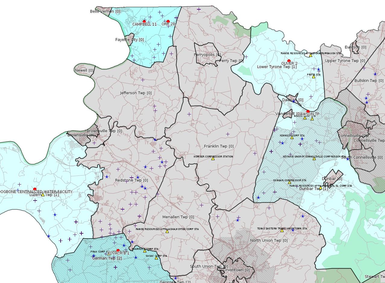
Fayette County Marcellus Shale Permits 11/27/17 - 12/17/17

Red dots: items in this permit list with an exact location.
Blue stars: Marcellus Gas Well Water Sources.
Municipality shading: number of "facilities", with each well counting separately
(includes the red dots):
pale turquoise: 1
turquoise: 2
pale blue: 3
middle blue: 4
dark blue: 5
dark purple: 8
purple: 19
(Color coding may differ from one issue to the next.)
(Note if a project spans multiple municipalities -- e.g. a pipeline -- it will show in the count for each municipality.)
The number of facilities also follows the municipality name in brackets.
Municipality counts are based on the way the permit is listed by DEP; DEP has been known to get a municipality wrong.
Locations in brackets identify a precise location used to locate a surrogate for the actual site being permitted (e.g. locating a well pad or pipeline by the known location of a well.) Locations labeled beginning with "~" and ending in "[?]" are approximate and speculative based on inferences using on-line property and lease records. These are marked in the text as "[Approximate, Speculative]
Yellow triangles: Compressor Stations
Orange triangles: Storage Field Wells (currently Dominion North Summit Storage Field)
Crosses: SPUD Unconventional well permits
Green: "Natural areas", e.g. state game lands, state forests
More Maps
 |
Source: Pennsylvania Bulletin
[Repeat listing from the 10/1/17 issue of this bulletin:]
Southwest Region: Waterways & Wetlands Program, 400 Waterfront Drive, Pittsburgh, PA 15222, Dana Drake, Waterways and Wetlands Program Manager, 412-442-4000.
| Facility Location and Municipality | Permit No. | Applicant Name and Address | Receiving Water/Use |
Contact Office and Phone No. |
|---|---|---|---|---|
| Luzerne Township | PAC260008 | Chevron Appalachia, LLC 700 Cherrington Drive Coraopolis, PA 15108 |
UNT to Rush Run (WWF) |
Fayette County Conservation District 10 Nickman Plaza Lemont Furnace, PA 15456 (724) 438-4497 |
Site: DOGBONE CENTRALIZED WATER FACILITY
Location: 39.972496,-79.946939 <http://osm.org/go/ZWpZaULM--?m=>
Municipalities: Luzerne Twp
Parcel Id: 19160040
Fayette County Act 14 Notification: <http://faymarwatch.org/documents/SKM_554e17050309530.pdf>
[See Notes.]
---
NOTICES
Extension of Erosion and Sediment Control General Permit (ESCGP-2) for Earth Disturbance Associated with Oil and Gas Exploration, Production, Processing or Treatment Operations or Transmission Facilities
[47 Pa.B. 7533]
[Saturday, December 9, 2017]
Under 25 Pa. Code § 102.5(m) (relating to permit requirements), The Clean Streams Law (35 P.S. §§ 691.1—691.1001), 58 Pa.C.S. §§ 3201—3274 (relating to development), and sections 1905-A, 1917-A and 1920-A of The Administrative Code of 1929 (71 P.S. §§ 510-5, 510-17 and 510-20), the Department of Environmental Protection (Department) is, by this notice, extending for 12 months the availability of the current Erosion and Sediment Control General Permit (ESCGP-2) for Earth Disturbance Associated with Oil and Gas Exploration, Production, Processing or Treatment Operations or Transmission Facilities.
The existing ESCGP-2 will expire on December 29, 2017. By this notice, the Department is administratively extending ESCGP-2 to December 29, 2018. Persons that are operating under the ESCGP-2 may continue to operate until December 29, 2018, or the expiration date of coverage identified on the permit coverage approval page, whichever is later. Persons may also continue to seek coverage under the ESCGP-2 during this administrative extension or until the new ESCGP-3 is issued if that issuance occurs before December 29, 2018. The Department is extending the availability of this permit to adequately complete preparation of the issuance of ESCGP-3.
To access the ESCGP-2 Permit and related documents, visit www.elibrary.dep.state.pa.us (select ''Permit and Authorization Packages,'' then ''Oil and Gas,'' then ''Environmental Controls,'' then ''Erosion and Sediment Control General Permit (ESCGP-2)'').
Questions regarding ESCGP-2 should be directed to Joseph Kelly, Chief, Division of Well Development and Surface Activities at (717) 772-5991 or josephkel@pa.gov.
PATRICK McDONNELL,
Secretary
<https://www.pabulletin.com/secure/data/vol47/47-49/2038.html>
[See Notes.]
-------------------------
Source: eNOTICE (+ PA Oil and Gas Mapping, Well Pad Report.) Well Details via Data Portal Services: Oil and Gas Wells All (ID: 3).
Please see the Disclaimer below regarding Parcel Id data.
[Conventional Well:]
Authorization ID: 1146844
Permit number: 051-23376
Site: HAMILTON-JOHNSON UNIT 3 OG WELL
Client: RANGE RESOURCES APPALACHIA LLC
Authorization type: Well Plugging Notice Alternate Method
Application type: New
Authorization is for: FACILITY
Date received: 07/25/2016
Status: Denied on 12/11/2017
Permit Decision Guarantee Applies?: No
Permit Review Notes:
Date Review Note
8/4/2016 Application has been deemed to be technically deficient and has been denied.
8/4/2016 Application has been deemed to be technically deficient and has been denied.
8/4/2016 The technical review and decision review are complete and either the permit decision and/or permit issuance are forthcoming.
8/4/2016 The permit application package is complete, has been accepted, and is undergoing technical review.
<http://www.ahs.dep.pa.gov/eFACTSWeb/searchResults_singleAuth.aspx?AuthID=1146844>
Site Programs:
Oil & Gas
Municipalities:
Georges Twp [an Environmental Justice Area], Fayette County
Well Details:
Permit Number: 051-23376
Well Name: HAMILTON-JOHNSON UNIT 3
Unconventional Well: N
Well Configuration: Vertical Well
Well Type: COMB. OIL&GAS
Well Status: Plugged OG Well
Coal Association: NonCoal
Conservation Well: N
Primary Facility ID: 683216
Site ID: 675894
Site Name: HAMILTON-JOHNSON UNIT 3 OG WELL
Well Pad ID: 0
Well Pad Name:
Storage Field:
Operator: RANGE RESOURCES APPALACHIA LLC
Operator Number: OGO-60915
Permit Date: 2006-08-17
Permit Date Expires: 2007-08-17
SPUD Date: 2006-10-11
Date Plugged: 2016-08-06
UIC ID:
UIC Type:
Surface Elevation: 1065
County: Fayette
Municipality: Georges Twp
Location: 39.803556,-79.823667
Map URL: <http://www.openstreetmap.org/?mlat=39.803556&mlon=-79.823667#map=15/39.803556/-79.823667>
Presumed Parcel Id: 14240076
Authorization ID: 1162243
Permit number: 051-23452
Site: ORR 28 OG WELL
Client: TAFT OPERATING LLC
Authorization type: Well Plugging Notice Alternate Method
Application type: New
Authorization is for: FACILITY
Date received: 12/09/2016
Status: Issued on 12/11/2017
Permit Decision Guarantee Applies?: No
Permit Review Notes:
Date Review Note
12/11/2017 The technical review and decision review are complete and either the permit decision and/or permit issuance are forthcoming.
12/12/2016 The permit application package is complete, has been accepted, and is undergoing technical review.
<http://www.ahs.dep.pa.gov/eFACTSWeb/searchResults_singleAuth.aspx?AuthID=1162243>
Site Programs:
Oil & Gas
Municipalities:
Washington Twp, Fayette County
Well Details:
Permit Number: 051-23452
Well Name: ORR 28
Unconventional Well: Y
Well Configuration: Vertical Well
Well Type: GAS
Well Status: Plugged OG Well
Coal Association: Coal
Conservation Well: Y
Primary Facility ID: 684955
Site ID: 678275
Site Name: ORR 28 OG WELL
Well Pad ID: 146291
Well Pad Name: ORR 28
Storage Field:
Operator: TAFT OPERATING LLC
Operator Number: OGO-40027
Permit Date: 2006-09-25
Permit Date Expires: 2007-09-25
SPUD Date: 2006-11-13
Date Plugged: 2017-02-06
UIC ID:
UIC Type:
Surface Elevation: 1178
County: Fayette
Municipality: Washington Twp
Location: 40.115393,-79.795546
Map URL: <http://www.openstreetmap.org/?mlat=40.115393&mlon=-79.795546#map=15/40.115393/-79.795546>
Presumed Parcel Id: 41190001
[See Notes.]
[Conventional Well:]
Authorization ID: 1166875
Permit number: 051-21242
Site: OLIVER 2 OG WELL
Client: RANGE RESOURCES APPALACHIA LLC
Authorization type: Well Plugging Notice Alternate Method
Application type: New
Authorization is for: FACILITY
Date received: 08/08/2016
Status: Issued on 12/11/2017
Permit Decision Guarantee Applies?: No
Permit Review Notes:
Date Review Note
1/23/2017 The technical review and decision review are complete and either the permit decision and/or permit issuance are forthcoming.
1/23/2017 The permit application package is complete, has been accepted, and is undergoing technical review.
<http://www.ahs.dep.pa.gov/eFACTSWeb/searchResults_singleAuth.aspx?AuthID=1166875>
Site Programs:
Oil & Gas
Municipalities:
Lower Tyrone Twp, Fayette County
Well Details:
Permit Number: 051-21242
Well Name: OLIVER 2
Unconventional Well: N
Well Configuration: Vertical Well
Well Type: GAS
Well Status: Plugged OG Well
Coal Association: NonCoal
Conservation Well: N
Primary Facility ID: 560540
Site ID: 541221
Site Name: OLIVER 2 OG WELL
Well Pad ID: 0
Well Pad Name:
Storage Field:
Operator: RANGE RESOURCES APPALACHIA LLC
Operator Number: OGO-60915
Permit Date: 2000-12-04
Permit Date Expires: 2001-12-04
SPUD Date: 2000-12-20
Date Plugged: 2016-08-14
UIC ID:
UIC Type:
Surface Elevation: 1270
County: Fayette
Municipality: Lower Tyrone Twp
Location: 40.080049,-79.660931
Map URL: <http://www.openstreetmap.org/?mlat=40.080049&mlon=-79.660931#map=15/40.080049/-79.660931>
Presumed Parcel Id: 18040086
Authorization ID: 1206221
Permit number: 051-24429
Site: POLK 1H OG WELL
Client: LPR ENERGY LLC
Authorization type: Drill & Operate Well Permit Inactive Status
Application type: New
Authorization is for: FACILITY
Date received: 11/09/2017
Status: Issued on 11/30/2017
Permit Decision Guarantee Applies?: No
Sub-Facilities for Authorization:
Sub-Facility ID Sub-Facility Name Description
1035637 POLK UNIT 2H Well
1035636 POLK UNIT 2H Well
Permit Review Notes:
Date Review Note
11/30/2017 The technical review and decision review are complete and either the permit decision and/or permit issuance are forthcoming.
11/30/2017 The permit application package is complete, has been accepted, and is undergoing technical review.
<http://www.ahs.dep.pa.gov/eFACTSWeb/searchResults_singleAuth.aspx?AuthID=1206221>
Site Programs:
Oil & Gas
Municipalities:
Wharton Twp, Fayette County
Well Details:
Permit Number: 051-24429
Well Name: POLK UNIT 2H
Unconventional Well: Y
Well Configuration: Horizontal Well
Well Type: GAS
Well Status: Regulatory Inactive Status
Coal Association: NonCoal
Conservation Well: N
Primary Facility ID: 738664
Site ID: 739411
Site Name: POLK 1H OG WELL
Well Pad ID: 149075
Well Pad Name: POLK UNIT 1H
Storage Field:
Operator: LPR ENERGY LLC
Operator Number: OGO-68579
Permit Date: 2011-02-28
Permit Date Expires: 2012-02-28
SPUD Date: 2011-08-26
Date Plugged:
UIC ID:
UIC Type:
Surface Elevation: 2310
County: Fayette
Municipality: Wharton Twp
Location: 39.746419,-79.529614
Map URL: <http://www.openstreetmap.org/?mlat=39.746419&mlon=-79.529614#map=15/39.746419/-79.529614>
Presumed Parcel Id: 4233000106
Authorization ID: 1208661
Permit number: 051-24432
Site: POLK 1H OG WELL
Client: LPR ENERGY LLC
Authorization type: Drill & Operate Well Permit Inactive Status
Application type: New
Authorization is for: FACILITY
Date received: 11/21/2017
Status: Pending
Permit Decision Guarantee Applies?: No
Sub-Facilities for Authorization:
Sub-Facility ID Sub-Facility Name Description
1035645 POLK UNIT 5H Well
1035644 POLK UNIT 5H Well
Permit Review Notes:
Date Review Note
12/6/2017 The permit application package is complete, has been accepted, and is undergoing technical review.
<http://www.ahs.dep.pa.gov/eFACTSWeb/searchResults_singleAuth.aspx?AuthID=1208661>
Site Programs:
Oil & Gas
Municipalities:
Wharton Twp, Fayette County
Well Details:
Permit Number: 051-24432
Well Name: POLK UNIT 5H
Unconventional Well: Y
Well Configuration: Horizontal Well
Well Type: GAS
Well Status: Regulatory Inactive Status
Coal Association: NonCoal
Conservation Well: N
Primary Facility ID: 738669
Site ID: 739411
Site Name: POLK 1H OG WELL
Well Pad ID: 149075
Well Pad Name: POLK UNIT 1H
Storage Field:
Operator: LPR ENERGY LLC
Operator Number: OGO-68579
Permit Date: 2011-02-28
Permit Date Expires: 2012-02-28
SPUD Date: 2011-12-01
Date Plugged:
UIC ID:
UIC Type:
Surface Elevation: 2310
County: Fayette
Municipality: Wharton Twp
Location: 39.746569,-79.529519
Map URL: <http://www.openstreetmap.org/?mlat=39.746569&mlon=-79.529519#map=15/39.746569/-79.529519>
Authorization ID: 1208662
Permit number: 051-24431
Site: POLK 1H OG WELL
Client: LPR ENERGY LLC
Authorization type: Drill & Operate Well Permit Inactive Status
Application type: New
Authorization is for: FACILITY
Date received: 11/21/2017
Status: Pending
Permit Decision Guarantee Applies?: No
Sub-Facilities for Authorization:
Sub-Facility ID Sub-Facility Name Description
1035642 POLK UNIT 4H Well
1035641 POLK UNIT 4H Well
<http://www.ahs.dep.pa.gov/eFACTSWeb/searchResults_singleAuth.aspx?AuthID=1208662>
Site Programs:
Oil & Gas
Municipalities:
Wharton Twp, Fayette County
Well Details:
Permit Number: 051-24431
Well Name: POLK UNIT 4H
Unconventional Well: Y
Well Configuration: Horizontal Well
Well Type: GAS
Well Status: Regulatory Inactive Status
Coal Association: NonCoal
Conservation Well: N
Primary Facility ID: 738667
Site ID: 739411
Site Name: POLK 1H OG WELL
Well Pad ID: 149075
Well Pad Name: POLK UNIT 1H
Storage Field:
Operator: LPR ENERGY LLC
Operator Number: OGO-68579
Permit Date: 2011-02-28
Permit Date Expires: 2012-02-28
SPUD Date: 2011-12-03
Date Plugged:
UIC ID:
UIC Type:
Surface Elevation: 2310
County: Fayette
Municipality: Wharton Twp
Location: 39.746531,-79.529544
Map URL: <http://www.openstreetmap.org/?mlat=39.746531&mlon=-79.529544#map=15/39.746531/-79.529544>
Authorization ID: 1209509
Permit number: 26-00594
Site: CALFRAC WELL SVCS CORP
Client: CALFRAC WELL SVCS CORP
Authorization type: Minor Source Operating Permit
Application type: Renewal
Authorization is for: FACILITY
Date received: 10/19/2017
Status: Pending
Permit Decision Guarantee Applies?: No
<http://www.ahs.dep.pa.gov/eFACTSWeb/searchResults_singleAuth.aspx?AuthID=1209509>
Site Programs:
Air Quality
Clean Water
Waste Management
Municipalities:
Georges Twp, Fayette County
Location: 39.81,-79.773333
<http://www.openstreetmap.org/?mlat=39.81&mlon=-79.77332&zoom=15&layers=M>
Presumed Parcel Id: 1425020722
[See Notes.]
Authorization ID: 1210110
Permit number: PA0217778
Site: DAWSON TP
Client: KEYROCK ENERGY LLC
Authorization type: Minor IW Facility with ELG
Application type: Renewal
Authorization is for: FACILITY
Date received: 11/28/2017
Status: Pending
Permit Decision Guarantee Applies?: No
Sub-Facilities for Authorization:
Sub-Facility ID Sub-Facility Name Description
1025459 OUTFALL 001 Discharge Point
<http://www.ahs.dep.pa.gov/eFACTSWeb/searchResults_singleAuth.aspx?AuthID=1210110>
Site Programs:
Clean Water
Oil & Gas
Municipalities:
Dunbar Twp, Fayette County
Location: 40.036247,-79.640533 [an Environmental Justice Area]
Map URL: <http://www.openstreetmap.org/?mlat=40.036247&mlon=-79.640533#map=15/40.036247/-79.640533>
Presumed Parcel Id: 09050007
[See Notes.]
New:
Authorization ID: 1210331
Permit number: ESX17-051-0003
Site: KOVACH B WELL SITE AND TANK SITE ESCGP ESX17-051-0003
Client: CHEVRON APPALACHIA LLC
Authorization type: Expedited E&S Stormwater General Permit 1
Application type: New
Authorization is for: SITE
Date received: 12/12/2017
Status: Pending
Permit Decision Guarantee Applies?: Yes
Permit Decision Guarantee status: ACTIVE
<http://www.ahs.dep.pa.gov/eFACTSWeb/searchResults_singleAuth.aspx?AuthID=1210331>
Site Programs:
Municipalities:
German Twp [an Environmental Justice Area], Fayette County
[For location information see the next entry.]
New:
Authorization ID: 1210459
Permit number: 051-24640
Site: KOVACH B
Client: CHEVRON APPALACHIA LLC
Authorization type: Drill & Operate Well Permit (Unconventional)
Application type: New
Authorization is for: FACILITY
Date received: 12/15/2017
Status: Pending
Permit Decision Guarantee Applies?: No
Sub-Facilities for Authorization:
Sub-Facility ID Sub-Facility Name Description
1250546 WELLBORE SURFACE HOLE LOCATION Well
<http://www.ahs.dep.pa.gov/eFACTSWeb/searchResults_singleAuth.aspx?AuthID=1210459>
Site Programs:
Oil & Gas
Municipalities:
German Twp [an Environmental Justice Area], Fayette County
Well Details:
Permit Number: 051-24640
Well Name: KOVACH B 1
Unconventional Well: Y
Well Configuration: Vertical Well
Well Type: GAS
Well Status: Active
Coal Association: Coal
Conservation Well: N
Primary Facility ID: 823474
Site ID: 826935
Site Name: KOVACH B
Well Pad ID: 155005
Well Pad Name: KOVACH B
Storage Field:
Operator: CHEVRON APPALACHIA LLC
Operator Number: OGO-39307
Permit Date:
Permit Date Expires:
SPUD Date:
Date Plugged:
UIC ID:
UIC Type:
Surface Elevation: 1278
County: Fayette
Municipality: German Twp
Location: 39.918967,-79.854906
Map URL: <http://www.openstreetmap.org/?mlat=39.918967&mlon=-79.854906#map=15/39.918967/-79.854906>
Presumed Parcel Id: 1511002301
-------------------------
Source: DEP Oil and Gas Compliance Report
OPERATOR: ATLAS RESOURCES LLC
INSPECTION_ID: 2664582
INSPECTION_DATE: 11/15/2017
INSPECTION_TYPE: Incident- Response to Accident or Event
API_PERMIT: 051-22938
FARM_NAME: CAMPBELL 11
UNCONVENTIONAL: No
SITE_ID: 659835
SITE_NAME: CAMPBELL 11 OG WELL
FACILITY_TYPE: Oil & Gas Location
INSPECTION_CATEGORY: Primary Facility
REGION: EP DOGO SWDO Dstr Off
COUNTY: Fayette
MUNICIPALITY: Washington Twp
INSPECTOR: NAJEWICZ, JUSTIN
INSPECTION_SOURCE: SAIR
INSPECTION_RESULT_DESCRIPTION: Violation(s) Noted
INSPECTION_COMMENT: "An incident response inspection was conducted due to a spill that occurred 11/10/2017. Approximately 35 gallons of crude oil and brine were spilled at the site. The operator believes a third party vehicle being driven on the access road struck the well, causing oil and brine to be released. Once discovered, the operator excavated the impacted area and disposed of the material on 11/15/17. At the time of inspection the site had been remediated, seeded, mulched, and new stone installed on the access road.
The incident has resulted in violations of 78.57(a) and SWMA 301."
VIOLATION_ID: 802989
VIOLATION_DATE: 11/15/2017
VIOLATION_CODE: 78.57(a) - CONTROL, STORAGE AND DISPOSAL OF PRODUCTION FLUIDS - Operator failed to collect the brine and other fluids produced during operation, service and plugging of the well in a tank, pit or a series of pits or tanks, or other device approved by the Department or Operator discharged brine or other fluids on or into the ground or into waters of the Commonwealth.
VIOLATION_TYPE: Environmental Health & Safety
VIOLATION_COMMENT: Operator discharged brine or other fluids.
RESOLVED_DATE:
RESOLUTION_REASON_CODE_DESCRIPTION:
ENFORCEMENT_ID:
ENFORCEMENT_CODE_DESCRIPTION: 359893
DATE_EXECUTED: NOV - Notice of Violation
ENFORCEMENT_FINAL_DATE: 11/28/2017
ENFORCEMENT_FINAL_STATUS:
PENALTY_FINAL_DATE:
PENALTY_FINAL_STATUS_CODE_DESCRIPTION:
PENALTY_AMOUNT:
TOTAL_AMOUNT_COLLECTED:
VIOLATION_ID: 802990
VIOLATION_DATE: 11/15/2017
VIOLATION_CODE: SWMA 301 - Failure to properly store, transport, process or dispose of a residual waste.
VIOLATION_TYPE: Environmental Health & Safety
VIOLATION_COMMENT: Failure to properly store and dispose of a residual waste.
RESOLVED_DATE:
RESOLUTION_REASON_CODE_DESCRIPTION:
ENFORCEMENT_ID:
ENFORCEMENT_CODE_DESCRIPTION: 359893
DATE_EXECUTED: NOV - Notice of Violation
ENFORCEMENT_FINAL_DATE: 11/28/2017
ENFORCEMENT_FINAL_STATUS:
PENALTY_FINAL_DATE:
PENALTY_FINAL_STATUS_CODE_DESCRIPTION:
PENALTY_AMOUNT:
TOTAL_AMOUNT_COLLECTED:
Well Details:
Permit Number: 051-22938
Well Name: CAMPBELL 11
Unconventional Well: N
Well Configuration: Vertical Well
Well Type: GAS
Well Status: Active
Coal Association: Coal
Conservation Well: N
Primary Facility ID: 671251
Site ID: 659835
Site Name: CAMPBELL 11 OG WELL
Well Pad ID: 0
Well Pad Name:
Storage Field:
Operator: ATLAS RESOURCES LLC
Operator Number: OGO-66455
Permit Date: 2005-09-16
Permit Date Expires: 2006-09-16
SPUD Date: 2006-08-14
Date Plugged:
UIC ID:
UIC Type:
Surface Elevation: 1022
County: Fayette
Municipality: Washington Twp
Location: 40.115596,-79.822339
Map URL: <http://www.openstreetmap.org/?mlat=40.115596&mlon=-79.822339#map=15/40.115596/-79.822339>
-------------------------
Source: Reuters Commodities: Energy
Natural Gas
| Commodity | Exchange | Currency | Expire | Last Trade | Trade Time | Change | Open | Day's High | Day's Low |
|---|---|---|---|---|---|---|---|---|---|
| NATURAL
GAS CON1 Dec17 |
NYM | USD | 12/27 | 2.76 | 12/19 00:57 | +0.01 | 2.73 | 2.76 | 2.73 |
<http://www.reuters.com/finance/commodities/energy>
-------------------------
Notes:
The Dogbone Centralized Water Facility was the subject of a hearing before the Fayette County Zoning Hearing Board, case ZHB 17-41, 12/13/17. The hearing was continued to 1/17/18 at 10 a.m. At the hearing Chevron testified that the facility was the subject of two different permits, permit # WMGR123SW025, which has been carried in this bulletin under Authorization ID: 1179749 (still pending), and a second Erosion & Sedimentation / NPDES permit which was being handled by the Fayette County Conservation District. They also testified that the project has been scaled back from 6 tanks (as notified to Fayette County in the Act 14 Notification) to 5 tanks, and projected that the E&S permit would be issued by Conservation District on the following day, 12/14/17. The permit # PAC260008 shown above appeared in the 9/23/17 issue of the PA Bulletin and has such meager metadata that it does not show either the issue date nor what the permit is for, so prior issues of this bulletin did not have it linked properly to the Dogbone Centralized Water Facility. Based on personal conversation with the Conservation District, it appears the 9/23/17 PA Bulletin listing is for the original 6-tank design, and that Chevron submitted a modification to the Conservation District for the 5-tank design. Presumably the modification PAC260008 will appear in the next issue of the PA Bulletin. It would appear from all of this that when a permit application is submitted direct to the Conservation District, there is no eFACTS listing for it and no "automatic" notification of any kind from the Conservation District; the only notification appears to be a listing in the PA Bulletin after the permit is issued.
---
ESCGP-2 is the permit needed to build a Marcellus well pad.
---
The well ORR 28 shown above is listed as an unconventional well, but it is not Marcellus. The producing interval for this well is the Oriskany Sandstone. For more information on the Oriskany Sandstone, see the note in the 11/13/16 issue of this bulletin,
<http://www.faymarwatch.org/happening/permits/111316.shtml#Oriskany>
---
The June 8, 2013 issue of the PA Bulletin lists the following information for Air Quality permit # 26-00594 for the CalFrac Plant:
26-00594: CalFrac Well Services, Corp.—CalFrac Plant (2001 Summit View Drive, Smithfield, PA 15478) on May 28, 2013, to operate a cement and fly ash storage facility for the oil and gas industry in Georges Township, Fayette County. The subject facility consists of four storage silos and two blend tanks control by a dust collector used to store materials used for oil and gas well isolation. The facility has the potential to emit less than 1.0 tpy PM / PM10. The facility is required to conduct a weekly survey of the facility during daylight hours while the facility is operating to ensure compliance with the visible emission, fugitive emission and malodor restrictions. Records of the weekly survey performed must be recorded. Monthly preventative maintenance inspections are to be performed on the control devices and recorded in an on-site log. The facility is also required to water all in-plant roads once per day, dependent on the weather, maintain a set vehicle pattern, post speed limit sign of 15 mph as well as promptly remove earth or other material from paved roads onto with earth or other material has been transported by trucking or earth moving equipment, or other means. Particulate matter emissions are not to exceed 0.04 gr/dscf. The proposed authorization is subject to State and Federal Regulations. The permit includes operation requirements, monitoring requirements, and recordkeeping requirements.
<https://www.pabulletin.com/secure/data/vol43/43-23/1035c.html>
---
There is some lack of precision in the exact overlay of GIS layers when doing mapping. At high resolution the location given for the DAWSON TP site actually falls within parcel 09010001, which is the Yough River Trail. It is unlikely that this is where the outfall actually is; the actual discharge is into an unnamed tributary of the Youghiogheny River. An entry for this permit from the PA Bulletin of April 20, 2013 shows:
PA0217778, SIC Code 1389, Keyrock Energy LLC, 106 Ferrell Avenue Suite 5, Kingsport, TN 37663-2371. Facility Name: Dawson Treatment Plant. This existing facility is located in Dunbar Township, Fayette County.
Description of Existing Activity: The application is for a renewal of an NPDES permit for an existing discharge of treated coalbed methane production water.
The receiving stream(s), Unnamed Tributary to Youghiogheny River, is located in State Water Plan watershed 19-D and is classified for Warm Water Fishes, aquatic life, water supply and recreation. The discharge is not expected to affect public water supplies.
The proposed effluent limits for Outfall 001 are based on a design flow of 0.06 MGD.
| Mass (lb/day) | Concentration (mg/l) | |||||
|---|---|---|---|---|---|---|
| Parameters | Average Monthly |
Daily Maximum |
Minimum | Average Monthly |
Daily Maximum |
Instant. Maximum |
| Flow (MGD) | Report | 0.06 | XXX | XXX | XXX | XXX |
| pH | XXX | XXX | 6 | XXX | XXX | 9 |
| Total Suspended Solids | XXX | XXX | XXX | 30 | XXX | 60 |
| Total Dissolved Solids | Report | Report | XXX | Report | Report | XXX |
| Oil and Grease | XXX | XXX | XXX | 15 | XXX | 30 |
| Acidity, Total (as CaCO3) | XXX | XXX | XXX | Report | Report | XXX |
| Alkalinity, Total (as CaCO3) | XXX | XXX | XXX | Report | Report | XXX |
| Alkalinity, Total (as CaCO3) | ||||||
| Effluent Net | XXX | XXX | XXX | Report | Report | XXX |
| Dissolved Iron | XXX | XXX | XXX | Report | Report | XXX |
| Total Iron | XXX | XXX | XXX | 3.5 | XXX | 7.0 |
| Chloride | Report | Report | XXX | Report | Report | XXX |
In addition, the permit contains the following major special conditions:
• Chemical Additives, Total Dissolved Solids—Chapter 95.10 Discharge Loadings
You may make an appointment to review the DEP files on this case by calling the File Review Coordinator at 412-442-4000.
The EPA Waiver is not in effect.
<https://www.pabulletin.com/secure/data/vol43/43-16/713.html>------------------------
DEP defines an environmental justice area as "any census tract where 20 percent or more individuals live in poverty, and/or 30 percent or more of the population is minority". (See:
<http://www.dep.pa.gov/PublicParticipation/OfficeofEnvironmentalJustice/Pages/default.aspx>). There are supposed to be enhanced public participation requirements for permits in environmental justice areas, but news of this actually ever happening is scarce. In Fayette County, the entirety of Springhill, Nicholson, German, and Georges Townships are environmental justice areas, as well as a large part of Dunbar Township. DEP's policy document on public participation guidelines for environmental justice areas is located here:
<http://www.elibrary.dep.state.pa.us/dsweb/Get/Version-48671/012-0501-002.pdf>
eNOTICE records are likely to list the same permit multiple times, as that permit moves through the DEP process.
Oil & Gas Wells designated with a site a number and the letter H typically designate horizontal wells.
-------------------------
Resources:
Pennsylvania Bulletin: <http://www.pabulletin.com/>
eNOTICE: <http://www.ahs2.dep.state.pa.
DEP Oil and Gas Reports: <http://www.dep.pa.gov/DataandTools/Reports/Oil%20and%20Gas%20Reports/Pages/default.aspx>
DEP Well Details Report: <https://www.paoilandgasreport
DEP Permits Issued Detail Report:
<http://www.depreportingservic
DEP SPUD (drilling started) Report:
<http://www.depreportingservices.state.pa.us/ReportServer/Pages/ReportViewer.aspx?/Oil_Gas/Spud_External_Data>
DEP Oil and Gas Compliance Report:
<http://www.depreportingservices.state.pa.us/ReportServer/Pages/ReportViewer.aspx?/Oil_Gas/OG_Compliance>
DEP PA Oil & Gas Mapping:
<http://www.depgis.state.pa.us/PaOilAndGasMapping>
Data Portal Services Directory [Technical]
<http://www.depgis.state.pa.us/arcgis/rest/services>
Query: Oil and Gas Wells All (ID: 3) [Technical]:
<http://www.depgis.state.pa.us/arcgis/rest/services/OilGas/OilGasAllStrayGas/MapServer/3/query?where=&text=&objectIds=&time=&geometry=&geometryType=esriGeometryEnvelope&inSR=&spatialRel=esriSpatialRelIntersects&relationParam=&outFields=OBJECTID%2CPERMIT_NUMBER%2CWELL_NAME%2COPERATOR%2COPERATOR_NUMBER%2CWELL_TYPE%2CWELL_TYPE_CODE%2CWELL_STATUS%2CWELL_STATUS_CODE%2CPERMIT_DATE%2CPERMIT_DATE_EXPIRES%2CSPUD_DATE%2CCONSERVATION_IND%2CCOUNTY%2CCOUNTY_ID%2CMUNICIPALITY%2CMUNICIPALITY_TYPE%2CMUNICIPALITY_CODE%2CLATITUDE%2CLONGITUDE%2CPRMRY_FID%2CUNCONVENTIONAL_IND%2CSURFACE_ELEVATION%2CWELL_CONFIG_CODE%2CCOAL_IND%2CWELL_PAD_NAME%2CSHAPE%2CDATE_PLUGGED%2CWELL_PAD_ID%2CUIC_ID%2CUIC_TYPE_DESCRIPTION%2CSTORAGE_FIELD_NAME%2CSITE_ID%2CSITE_NAME&returnGeometry=true&returnTrueCurves=false&maxAllowableOffset=&geometryPrecision=&outSR=&returnIdsOnly=false&returnCountOnly=false&orderByFields=&groupByFieldsForStatistics=&outStatistics=&returnZ=false&returnM=false&gdbVersion=&returnDistinctValues=false&resultOffset=&resultRecordCount=&f=html>
(Be sure to enter a Where clause in SQL format. Dates are in milliseconds since midnight 1/1/1970).
DEP Oil and Gas Electronic Notifications
<http://www.depreportingservices.state.pa.us/ReportServer?/Oil_Gas/OG_Notifications>
DEP Oil and Gas Well Pad Report
<http://www.depreportingservices.state.pa.us/ReportServer?/Oil_Gas/Well_Pads>
Fayette County Assessment Office Search For Tax Records:
<http://property.co.fayette.pa.us/search.aspx>
Pennsylvania Spatial Data Access:
<http://www.pasda.psu.edu/default.asp>
DEP Spatial Data Repository:
<ftp://www.pasda.psu.edu/pub/pasda/dep/>
National Response Center:
<http://www.nrc.uscg.mil/>
EPA-Echo: <http://www.epa-echo.gov/echo/
FERC citizen involvement: <http://www.ferc.gov/for-citiz
<http://www.ferc.gov/docs-fili
Follow the directions and enter the docket number to subscribe to.
Township Supervisors receive information regarding Erosion & Sedimentation permits, and these records may be reviewable at township municipal offices.
DEP permits are reviewable through the File Review process, for application to do file review see: <http://www.portal.state.pa.us/portal/server.pt/community/southwest_regional_office/13775/file_review/593164>
Environmental Hearing Board: <http://ehb.courtapps.com/publ
PA DEP Environmental Policy Comment System:
<http://www.ahs.dep.pa.gov/eComment/>
Federal Register Environment: <https://www.federalregister.g
SkyTruth Fayette County Drilling Alerts: <http://frack.skytruth.org/pen
U.S. Army Corps of Engineers, Pittsburgh District, Public Notices:
<http://www.lrp.usace.army.mil/Missions/Regulatory/Public-Notices/>
EPA Pennsylvania Public Notices: <http://www2.epa.gov/aboutepa/epa-pennsylvania#notice>
Energy Assurance Daily: <http://www.oe.netl.doe.gov/ead.aspx>
-------------------------
Disclaimers:
This compilation from the above sources was done by hand using copy and paste and may omit relevant permits.
Parcel data is provided via the tax records search web page offered by the Fayette County Assessment Office (http://property.co.fayette.pa.us/). Presumed Parcel Id links are subject to availability provided by that agency and associated web sites. Presumed Parcel Ids are determined as the mapped parcel containing a given latitude and longitude, are a best effort determination which is subject to error, and are not official. In cases where a facility is leased and there is a separate parcel id for the lease, if this parcel id is not separately mapped, the parcel id shown will be the id for the enclosing parcel. Parcel owners may be surface owners only and may or may not have any relationship to oil & gas facilities.
Does not currently include water supply permits. Does not include landfill permits even though many such are for Marcellus Shale waste. (It is not possible at this time to distinguish which landfill permits are for Marcellus Shale waste and which are not without doing File Review for each permit.)
Erosion & Sedimentation permit records do not currently include latitude and longitude. Where I am publishing latitude and longitude with E&S permits it is by inferring an associated well permit and using published latitude and longitude for the well. It is possible I may be inferring the wrong well site.
Municipalities are shown from eFACTS records on the DEP web site. The DEP has been known to list a municipality incorrectly.