The Harmed Success Stories Concepts How To What Is Commentary
Fayette County Marcellus Shale Permits 12/15/14 - 12/28/14
Click the map to enlarge
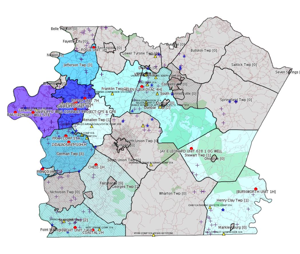
Map
Key
Red dots: items in this permit list with an exact location.
Orange triangles: Notifications in this permit list with an exact location.
Blue stars: Marcellus Gas Well Water Sources.
Municipality shading: number of "facilities", with each well counting separately
(includes the red dots):
Red dots: items in this permit list with an exact location.
Orange triangles: Notifications in this permit list with an exact location.
Blue stars: Marcellus Gas Well Water Sources.
Municipality shading: number of "facilities", with each well counting separately
(includes the red dots):
gray: 0
pale turquoise: 1
turquoise: 2
pale blue: 3
middle blue: 4
dark blue: 6
dark purple: 7
purple: 11
(Color coding may differ from one issue to the next.)
(Note if a project spans multiple municipalities -- e.g. a pipeline -- it will show in the count for each municipality.)
The number of facilities also follows the municipality name in brackets.
Municipality counts are based on the way the permit is listed by DEP; DEP has been known to get a municipality wrong.
Locations in brackets identify a precise location used to locate the actual site being permitted (e.g. locating a well pad or pipeline by the known location of a well.) Locations labeled beginning with "~" and ending in "[?]" are approximate and speculative based on inferences using on-line property and lease records. These are marked in the text as "[Approximate, Speculative]
eFACTS/eNOTICE applications of type Notification are not mapped.
Cross-hatching: Environmental
Justice
Areas
Yellow triangles: Compressor Stations
Crosses: Unconventional well permits (may not have been drilled)
Green: "Natural areas", e.g. state game lands, state forests
Yellow triangles: Compressor Stations
Crosses: Unconventional well permits (may not have been drilled)
Green: "Natural areas", e.g. state game lands, state forests
More Maps
 |
 |
|
Source: Pennsylvania Bulletin
Helen Bukovac #4 Well Site, 760 Little Summit Road Extension, Dunbar Township, Fayette County. Groundwater & Environmental Services, Inc., 301 Commerce Park Drive, Cranberry Township, PA 16066 on behalf of XTO Energy Inc., 395 Airport Road, Indiana, PA 15701 has submitted a Final Report to demonstrate attainment of a combination of residential Statewide Health and Site Specific Standards concerning site soils contaminated with aluminum, antimony, arsenic, barium, beryllium boron, cadmium chromium, cobalt, copper, iron lead, manganese, mercury, nickel, selenium, silver, thallium, vanadium, zinc and chloride. Notice of the Final Report was published in the Daily Courier on July 15, 2014.
<http://www.pabulletin.com/secure/data/vol44/44-51/2628d.html>
Site: HELEN BUKOVAC #4 WELL SITE
Site ID: 783992
Location [of HELEN K BUKOVAC 4H] 40.010133,-79.672622 [an Environmental Justice Area]
<http://osm.org/go/ZWp2lQXc--?m=>
ESCGP-2 No.: ESX14-051-0014
Applicant Name: Chevron Appalachia LLC
Contact Person: Alex Genovese
Address: 800 Mountain View Drive
City: Smithfield State: PA Zip Code: 15478
County: Fayette Township(s): German
Receiving Stream(s) and Classifications: UNTs to Dunlap
Creek/Middle Monongahela River Watershed; Other
WWF
<http://www.pabulletin.com/secure/data/vol44/44-51/2628e.html>
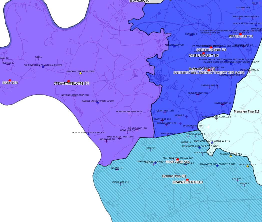
Site: ZALAC UNIT #5-11H WELL SITE ESCGP-2 EXPEDITED
Location: 39.904511,-79.858119 <http://osm.org/go/ZWpaKFq~--?m=>
Municipalities: German Twp [an Environmental Justice Area]
-------------------------
Source: eNOTICE (+ PA Oil and Gas Mapping)
Authorization ID: 1054393
Permit number: 051-24617
Site: ZALAC UNIT #5-11H WELL SITE ESCGP-2 EXPEDITED
Client: CHEVRON APPALACHIA LLC
Authorization type: Drill & Operate Well Permit
Application type: New
Authorization is for: FACILITY
Date received: 11/24/2014
Status: Pending
Sub-Facility ID Sub-Facility Name Description
1150489 ZALAC UNIT 10H Well
<http://www.ahs.dep.pa.gov/eFACTSWeb/searchResults_singleAuth.aspx?AuthID=1054393>
Conservation Well: N
Location: 39.904611,-79.858172 <http://osm.org/go/ZWpaKHEP--?m=>
Municipalities: German Twp [an Environmental Justice Area]
Authorization ID: 1050186
Permit number: ESX14-051-0016
Site: STEWART WELL SITE ESCGP-2 EXPEDITED
Client: CHEVRON APPALACHIA LLC
Authorization type: Expedited E&S Stormwater General Permit 1
Application type: New
Authorization is for: SITE
Date received: 11/07/2014
Status: Pending
<http://www.ahs.dep.pa.gov/eFACTSWeb/searchResults_singleAuth.aspx?AuthID=1050186>
Location: 39.962961,-79.946956 <http://osm.org/go/ZWpZPAOD--?m=>
Municipalities: Luzerne Twp
Authorization ID: 1040092
Permit number: ESX14-051-0013
Site: KNIGHT 14-20H WELL SERVICE CONNECT ESCGP-2 EXPEDITED
Client: CHEVRON APPALACHIA LLC
Authorization type: Expedited E&S Stormwater General Permit 1
Application type: New
Authorization is for: SITE
Date received: 08/27/2014
Status: Issued on 12/17/2014
<http://www.ahs.dep.pa.gov/eFACTSWeb/searchResults_singleAuth.aspx?AuthID=1040092>
Location [of KNIGHT UNIT 14H]: 39.738978,-79.844828 <http://osm.org/go/ZWpKkMoT--?m=>
Municipalities: Springhill Twp [an Environmental Justice Area]
Authorization ID: 1051811
Permit number: GP5-26-00546B
Site: PRAH COMP STA GERMAN TWP
Client: LAUREL MTN MIDSTREAM OPR LLC
Authorization type: AQ General Permit
Application type: New
Authorization is for: FACILITY
Date received: 11/21/2014
Status: Pending
Sub-Facility ID Sub-Facility Name Description
943514 CATERPILLAR G3516TALE 1340 BHP ENGINE 1 Process
943546 CATERPILLAR G3516TALE 1340 BHP ENGINE 2 Process
<http://www.ahs.dep.pa.gov/eFACTSWeb/searchResults_singleAuth.aspx?AuthID=1051811>
Location: 39.916422,-79.865258 <http://osm.org/go/ZWpaMa6C--?m=>
Municipalities: German Twp [an Environmental Justice Area]
Fayette County Parcel ID 15-11-0031
[See Notes.]
Authorization ID: 1054649
Permit number: WMGR123SW001
Site: RONCO
Client: SHALLENBERGER CONST INC
Authorization type: Minor Modification to an Existing Fac
Application type: Modification
Authorization is for: FACILITY
Date received: 12/12/2014
Status: Pending
Sub-Facility ID Sub-Facility Name Description
1024777 RESIDUAL WASTE PROC FAC Processing Facility
<http://www.ahs.dep.pa.gov/eFACTSWeb/searchResults_singleAuth.aspx?AuthID=1054649>
Location: 39.852778,-79.924722 <http://osm.org/go/ZWpM2V0y--?m=>
Municipalities: Masontown Boro
Authorization ID: 1054842
Permit number: 051-24619
Site: SANFILIPPO WELL SITES ESCGP-EXPEDITED
Client: CHEVRON APPALACHIA LLC
Authorization type: Drill & Operate Well Permit
Application type: New
Authorization is for: FACILITY
Date received: 11/25/2014
Status: Pending
Sub-Facility ID Sub-Facility Name Description
1150696 SANFILIPPO UNIT 7H Well
<http://www.ahs.dep.pa.gov/eFACTSWeb/searchResults_singleAuth.aspx?AuthID=1054842>
Conservation Well: N
Location: 39.981538,-79.8388 <http://osm.org/go/ZWpb0vHu--?m=>
Municipalities: Redstone Twp
Authorization ID: 1054843
Permit number: 051-24620
Site: SANFILIPPO WELL SITES ESCGP-EXPEDITED
Client: CHEVRON APPALACHIA LLC
Authorization type: Drill & Operate Well Permit
Application type: New
Authorization is for: FACILITY
Date received: 11/25/2014
Status: Pending
Sub-Facility ID Sub-Facility Name Description eMap PA Location
1150697 SANFILIPPO UNIT 8H Well
<http://www.ahs.dep.pa.gov/eFACTSWeb/searchResults_singleAuth.aspx?AuthID=1054843>
Conservation Well: N
Location: 39.978247,-79.844608 <http://osm.org/go/ZWpbxcvv--?m=>
Municipalities: Redstone Twp
[See Notes.]
Authorization ID: 1055059
Permit number: ESX14-051-0017
Site: SANFILIPPO WELL CONNECT PROJECT ESCGP-2 EXPEDITED
Client: LAUREL MTN MIDSTREAM OPR LLC
Authorization type: Expedited E&S Stormwater General Permit 1
Application type: New
Authorization is for: SITE
Date received: 12/17/2014
Status: Pending
<http://www.ahs.dep.pa.gov/eFACTSWeb/searchResults_singleAuth.aspx?AuthID=1055059>
Municipalities: Redstone Twp
Authorization ID: 1055284
Permit number: GP05260714007
Site: SANFILIPPO WELL CONNECT PROJECT GP5 & GP8
Client: LAUREL MTN MIDSTREAM OPR LLC
Authorization type: GP-05 Utility Line Stream Crossings
Application type: New
Authorization is for: FACILITY
Date received: 12/17/2014
Status: Pending
Sub-Facility ID Sub-Facility Name Description
1150994 SANFILIPPO WELL CONNECT GP5 Pipeline or Conduit
<http://www.ahs.dep.pa.gov/eFACTSWeb/searchResults_singleAuth.aspx?AuthID=1055284>
Location: 39.968333,-79.840833 <http://osm.org/go/ZWpbwimq--?m=>
Municipalities: Redstone Twp
Authorization ID: 1055287
Permit number: GP08260714004
Site: SANFILIPPO WELL CONNECT PROJECT GP5 & GP8
Client: LAUREL MTN MIDSTREAM OPR LLC
Authorization type: GP-08 Temporary Road Crossings
Application type: New
Authorization is for: FACILITY
Date received: 12/17/2014
Status: Pending
<http://www.ahs.dep.pa.gov/eFACTSWeb/searchResults_singleAuth.aspx?AuthID=1055287>
Sub-Facilities for Authorization
Sub-Facility ID Sub-Facility Name Description eMap PA Location
1150997 SANFILIPPO WELL CONNECT GP8 Culvert
Authorization ID: 1036791
Permit number: ESX14-051-0012
Site: GRINDSTONE PIPELINE PROJECT ESCGP-2 EXPEDITED
Client: LAUREL MTN MIDSTREAM OPR LLC
Authorization type: Expedited E&S Stormwater General Permit 1
Application type: New
Authorization is for: SITE
Date received: 08/04/2014
Status: Pending
<http://www.ahs.dep.pa.gov/eFACTSWeb/searchResults_singleAuth.aspx?AuthID=1036791>
Municipalities: Franklin Twp, Jefferson Twp
Authorization ID: 1050673
Permit number: 051-24525
Site: CHESS 1H ESCGP-EXPEDITED
Client: BURNETT OIL CO INC
Authorization type: Drill & Operate Well Permit
Application type: Renewal
Authorization is for: FACILITY
Date received: 10/20/2014
Status: Issued on 12/23/2014
<http://www.ahs.dep.pa.gov/eFACTSWeb/searchResults_singleAuth.aspx?AuthID=1050673>
Location: 39.859844,-79.7907 <http://osm.org/go/ZWplCMCe--?m=>
Municipalities: Georges Twp [an Environmental Justice Area]
Authorization ID: 1047032
Permit number: ESX11-051-0008
Site: LESTER TO NORTH 12 PIPELINE ESCGP-EXPEDITED
Client: LAUREL MTN MIDSTREAM OPR LLC
Authorization type: Expedited E&S Stormwater General Permit 1
Application type: Notification
Authorization is for: SITE
Date received: 10/16/2014
Status: Issued on 12/19/2014
<http://www.ahs.dep.pa.gov/eFACTSWeb/searchResults_singleAuth.aspx?AuthID=1047032>
Municipalities: Jefferson Twp
Authorization ID: 1055438
Permit number: ESX11-051-0021
Site: DUNBAR TO DANCHO BROWN PIPELINE ESCGP-EXPEDITED
Client: LAUREL MTN MIDSTREAM OPR LLC
Authorization type: Expedited E&S Stormwater General Permit 1
Application type: Notification
Authorization is for: SITE
Date received: 12/23/2014
Status: Pending
<http://www.ahs.dep.pa.gov/eFACTSWeb/searchResults_singleAuth.aspx?AuthID=1055438>
Municipalities: Dunbar Boro, Franklin Twp, Menallen Twp
Authorization ID: 1035789
Permit number: GP112614205
Site: NORTH UNION TWP- FAYETTE CO RD SYS
Client: NORTH UNION TWP FAYETTE CNTY
Authorization type: BWM-GP-11 Maintenance, Testing, Repair, Rehabilitation or Replacement General Pmt
Application type: New
Authorization is for: FACILITY
Date received: 07/17/2014
Status: Pending
Sub-Facility ID Sub-Facility Name Description
[Off-topic sub-facilities omitted]
1140718 TEXAS EASTERN PIPELINE EROSION Pipeline or Conduit
<http://www.ahs.dep.pa.gov/eFACTSWeb/searchResults_singleAuth.aspx?AuthID=1035789>
Location: 39.928889,-79.643889 <http://osm.org/go/ZWpy42Rm--?m=>
Municipalities: North Union Twp
[Conventional Well]
Authorization ID: 1055431
Permit number: 051-20051
Site: JAY E LEONARD UNIT 628 1 OG WELL
Client: XTO ENERGY INC
Authorization type: Well Plugging Notice Intent to Plug Single Well
Application type: New
Authorization is for: FACILITY
Date received: 12/16/2014
Status: Pending
Sub-Facility ID Sub-Facility Name Description eMap PA Location
56258 JAY E LEONARD UNIT 628 1 Well
<http://www.ahs.dep.pa.gov/eFACTSWeb/searchResults_singleAuth.aspx?AuthID=1055431>
Location: 39.888691,-79.551041 <http://osm.org/go/ZWpt7Qi1--?m=>
Municipalities: Stewart Twp
Authorization ID: 1051951
Permit number: ESX10-051-0028
Site: BURNWORTH FRESHWATER IMPOUNDMENT ESCGP-EXPEDITED
Client: CHIEF OIL & GAS LLC
Authorization type: Expedited E&S Stormwater General Permit 1
Application type: Notification
Authorization is for: SITE
Date received: 11/24/2014
Status: Withdrawn on 12/22/2014
<http://www.ahs.dep.pa.gov/eFACTSWeb/searchResults_singleAuth.aspx?AuthID=1051951>
Location [of BURNWORTH UNIT 1H]: 39.808139,-79.390917 <http://osm.org/go/ZWrB22cP--?m=>
Municipalities: Henry Clay Twp
Authorization ID: 1054727
Permit number: 051-24618
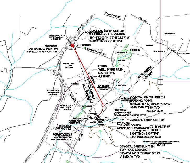
Site: COASTAL 1H FLOW BACK PIT FRESHWATER PITS ESCGP-EXPEDITED
Client: BURNETT OIL CO INC
Authorization type: Drill & Operate Well Permit
Application type: New
Authorization is for: FACILITY
Date received: 12/17/2014
Status: Pending
Sub-Facility ID Sub-Facility Name Description
1150653 WELLBORE SURFACE HOLE LOCATION [Should be COASTAL SMITH UNIT 2H -jr] Well
<http://www.ahs.dep.pa.gov/eFACTSWeb/searchResults_singleAuth.aspx?AuthID=1054727>
Location: 39.733371,-79.80094 <http://osm.org/go/ZWpgBJ3s--?m=>
Municipalities: Springhill Twp
Conservation Well: N
Permit Application:
<http://www.depgis.state.pa.us/PaOilAndGasMapping/eWellDocServiceFetcher.ashx?Doc=5xEy7%2f39Ax%2f4CX%2ff%2fOCsug%3d%3d>
-------------------------
Source: DEP SPUD (drilling started) Report
SPUD_DATE: 12/17/14
API: 051-24596
OGO_NUM: OGO-39307
OPERATOR: CHEVRON APPALACHIA LLC
MUNICIPALITY: Luzerne Twp
FARM_NAME: BAILY UNIT 12H
WELL_CODE_DESC: GAS
WELL_STATUS: Active
LATITUDE: 39.963755
LONGITUDE: -79.991394
CONFIGURATION: Horizontal Well
UNCONVENTIONAL: Yes
SPUD_DATE: 12/19/14
API: 051-24597
OGO_NUM: OGO-39307
OPERATOR: CHEVRON APPALACHIA LLC
MUNICIPALITY: Luzerne Twp
FARM_NAME: BAILY UNIT 13H
WELL_CODE_DESC: GAS
WELL_STATUS: Active
LATITUDE: 39.963794
LONGITUDE: -79.991488
CONFIGURATION: Horizontal Well
UNCONVENTIONAL: Yes
SPUD_DATE: 12/21/14
API: 051-24598
OGO_NUM: OGO-39307
OPERATOR: CHEVRON APPALACHIA LLC
MUNICIPALITY: Luzerne Twp
FARM_NAME: BAILY UNIT 14H
WELL_CODE_DESC: GAS
WELL_STATUS: Active
LATITUDE: 39.963719
LONGITUDE: -79.991419
CONFIGURATION: Horizontal Well
UNCONVENTIONAL: Yes
SPUD_DATE: 12/23/14
API: 051-24599
OGO_NUM: OGO-39307
OPERATOR: CHEVRON APPALACHIA LLC
MUNICIPALITY: Luzerne Twp
FARM_NAME: BAILY UNIT 15H
WELL_CODE_DESC: GAS
WELL_STATUS: Active
LATITUDE: 39.963758
LONGITUDE: -79.991513
CONFIGURATION: Horizontal Well
UNCONVENTIONAL: Yes
SPUD_DATE: 12/25/14
API: 051-24600
OGO_NUM: OGO-39307
OPERATOR: CHEVRON APPALACHIA LLC
MUNICIPALITY: Luzerne Twp
FARM_NAME: BAILY UNIT 16H
WELL_CODE_DESC: GAS
WELL_STATUS: Active
LATITUDE: 39.963683
LONGITUDE: -79.991444
CONFIGURATION: Horizontal Well
UNCONVENTIONAL: Yes
SPUD_DATE: 12/27/14
API: 051-24601
OGO_NUM: OGO-39307
OPERATOR: CHEVRON APPALACHIA LLC
MUNICIPALITY: Luzerne Twp
FARM_NAME: BAILY UNIT 17H
WELL_CODE_DESC: GAS
WELL_STATUS: Active
LATITUDE: 39.963722
LONGITUDE: -79.991538
CONFIGURATION: Horizontal Well
UNCONVENTIONAL: Yes
-------------------------
Source: DEP Oil and Gas Compliance Report
OPERATOR: CHEVRON APPALACHIA LLC
INSPECTION_ID: 2331108
INSPECTION_DATE: 12/13/14
INSPECTION_TYPE: Administrative/File Review
API_PERMIT: 051-24590
FARM_NAME: RITTER UNIT 7H
UNCONVENTIONAL: Y
SITE_ID: 766655
SITE_NAME: RITTER 1H, 2H, 3H, 4H AND 5H
FACILITY_TYPE: Oil & Gas Location
INSPECTION_CATEGORY: Primary Facility
MUNICIPALITY: Redstone Twp
INSPECTION_RESULT_DESCRIPTION: In Compliance with Policy
INSPECTION_COMMENT: SPILL. ON 12/13 AT 1041, RELEASE OF 75 BBL FRAC WATER REPORTED TO FIRST CHOICE TELEPHONE ANSWERING SERVICE BY OPERATOR REPRESENTATIVE BETH SMOCK. RELEASE OCCURRED ON CONTAINMENT, REPORTED TO BE CLEANED UP AT TIME OF THIS NOTIFICATION. ON 12/13 AT 1128, A REPEAT NOTIFICATION WAS REPORTED TO FIRST CHOICE TELEPHONE ANSWERING SERVICE BY OPERATOR REPRESENTATIVE MATT BARCH.
Location: 39.989144,-79.816458 <http://osm.org/go/ZWpb9_PO--?m=>
OPERATOR: CHEVRON APPALACHIA LLC
INSPECTION_ID: 2331119
INSPECTION_DATE: 12/15/14
INSPECTION_TYPE: Administrative/File Review
API_PERMIT: 051-24479
FARM_NAME: ROSUL UNIT 1H
UNCONVENTIONAL: Y
SITE_ID: 753789
SITE_NAME: ROSUL UNIT EAST OG WELL PAD
FACILITY_TYPE: Oil & Gas Location
INSPECTION_CATEGORY: Primary Facility
REGION: EP DOGO SWDO Dstr Off
COUNTY: Fayette
MUNICIPALITY: Jefferson Twp
INSPECTION_RESULT_DESCRIPTION: In Compliance with Policy
INSPECTION_COMMENT: SPILL. ON 12/15 AT 1105, A RELEASE OF 50 GALLONS FLOWBACK WATER WAS REPORTED TO SWRO REPRESENTATIVE CAROL STACOVIAK BY OPERATOR REPRESENTATIVE B.A. LAMBIE. RELEASE OCCURRED AT 1100 ONTO SITE CONTAINMENT AND IS CURRENTLY BEING VAC'D UP.
Location: 40.0876,-79.792428 <http://osm.org/go/ZWsgDR77--?m=>
-------------------------
Source: PA Oil and Gas Mapping
Site Inspection for Site ID - 777526 - BAILY 8-17H WELL SITE ESCGP-2 EXPEDITED.
Inspection ID: 2329749
Date Inspected: 12/9/2014
Inspection Type Description: Preoperation Inspection
Inspection Result Description: Violation(s) Noted
Violations: 1
Inspection Comment: Pre-operation inspection. This ESCGP-2 was issued on 10/28/2013 and expires on 10/27/2018. Well pad in process of being rocked. Maintenance currently being performed on access road to pad and access road to tank pad. Tank pad not yet rocked. Rip-rap being implemented per the E&S plan. Perimeter E&S controls installed per on-site E&S plan and appear to be functioning properly. No signs of accelerated erosion and/or sedimentation issues observed at this time.Disturbed perimeters of access road temporarily stabilized with seed/mulch, minimal growth observed. Per Mr. Diamond, additional seeding/mulching to occur along entire site today upon completion of current and final construction activities, prior to spudding. RCE to be installed at access road entrance per the approved E&S plan, however access road entrance is paved. As no revisions and/or modifications are currently on record to account for this alteration, violations are being issued for failure to comply with the standard permit conditions as set forth in the approved ESCGP-2.
[See Notes.]
-------------------------
Source: Reuters Commodities: Energy
Natural Gas
| Commodity | Exch | Currency | Expire | Last | Trade Date/Time |
Net Chg | Open | High | Low |
|---|---|---|---|---|---|---|---|---|---|
| NATURAL
GAS CON1 Dec14 |
NYM | USD | 12/29 | 3.45 | 12/19 17:14 | -0.18 | 3.66 | 3.68 | 3.44 |
-------------------------
Notes:
The Fayette County Office of Planning, Zoning, and Community Development can find no record that the Prah Compressor Station received a Special Exception for Public / Private Works from the Zoning Hearing Board. Fayette County apparently did not receive notification of the permit application above as required under Act 14.
There are two Sanfilippo well pads located in close proximity; the two Drill & Operate Well permits for Sanfilippo listed above are 1 each for the two separate well pads.
The inspection report for Inspection ID 2329749 cited above under PA Oil and Gas Mapping should have shown up under DEP Oil and Gas Compliance Report. That it doesn't is apparently a bug. There seems to be no way to copy to the clipboard information from an inspection report accessed via PA Oil and Gas Mapping. Alas, the information cited above for this inspection was retyped.
------------------------
DEP defines an environmental justice area as "any census tract where 20 percent or more individuals live in poverty, and/or 30 percent or more of the population is minority". (See:
<http://www.portal.state.pa.us/portal/server.pt/community/pa_environmental_justice_areas/20991>
<http://www.portal.state.pa.us/portal/server.pt/community/dep_enhanced_public_participation_policy/20988>
). There are supposed to be enhanced public participation requirements for permits in environmental justice areas, but news of this actually ever happening is scarce. In Fayette County, the entirety of Springhill, Nicholson, German, and Georges Townships are environmental justice areas, as well as a large part of Dunbar Township. DEP's policy document on public participation guidelines for environmental justice areas is located here:
<http://www.elibrary.dep.state.pa.us/dsweb/Get/Version-48671/012-0501-002.pdf>
eNOTICE records are likely to list the same permit multiple times, as that permit moves through the DEP process.
Oil & Gas Wells designated with a site a number and the letter H typically designate horizontal wells.
The eMapPa web site does not work in web browsers other than Internet Explorer. For instructions on how to view eMapPa data in Firefox send me E-mail.
-------------------------
Resources:
Pennsylvania Bulletin: <http://www.pabulletin.com/>
eNOTICE: <http://www.ahs2.dep.state.pa.
DEP Well Details Report: <https://www.paoilandgasreport
Well Details may not show any
information for new permits and will not
show permits which have not yet been issued. Lookup for Well Details is
by permit number.
DEP Permits Issued Detail Report:
<http://www.depreportingservic
DEP SPUD (drilling started) Report:
<http://www.depreportingservices.state.pa.us/ReportServer/Pages/ReportViewer.aspx?/Oil_Gas/Spud_External_Data>
DEP Oil and Gas Compliance Report:
<http://www.depreportingservices.state.pa.us/ReportServer/Pages/ReportViewer.aspx?/Oil_Gas/OG_Compliance>
DEP PA Oil & Gas Mapping:
<http://www.depgis.state.pa.us/PaOilAndGasMapping>
Pennsylvania Spatial Data Access:
<http://www.pasda.psu.edu/default.asp>
DEP Spatial Data Repository:
<ftp://www.pasda.psu.edu/pub/pasda/dep/>
National Response Center:
<http://www.nrc.uscg.mil/>
EPA-Echo: <http://www.epa-echo.gov/echo/
FERC citizen involvement: <http://www.ferc.gov/for-citiz
To receive E-mail notification of all
documents filed in a FERC docket,
see:
<http://www.ferc.gov/docs-filing/esubscription.asp >
<http://www.ferc.gov/docs-fili
Follow the directions and enter the docket number to subscribe to.
Township Supervisors receive information regarding Erosion & Sedimentation permits, and these records may be reviewable at township municipal offices.
DEP permits are reviewable through the File Review process, for application to do file review see: <http://www.portal.state.pa.us/portal/server.pt/community/southwest_regional_office/13775/file_review/593164>
Environmental Hearing Board: <http://ehb.courtapps.com/publ
PA DEP Public Participation Center Proposals Currently Open for Comment:
<http://www.portal.state.pa.us
This location contains links for open
public comment periods.
Federal Register Environment: <https://www.federalregister.g
Browsing of recent comment
opportunities for federal agencies, e.g.
EPA. Click "sign up" to subscribe to daily E-mails of new document
listings.
SkyTruth Fayette County Drilling Alerts: <http://frack.skytruth.org/pen
EPA Region 3 Water Protection Public Notices: <http://www.epa.gov/reg3wapd/p
Marcellus Shale waste disposal
injection wells in Pennsylvania are
regulated directly by EPA, not DEP. Notice of any new permit
applications will appear at the above web address. I'm not aware
of any subscription service to be notified of such applications. I'm
not aware of any Marcellus Shale waste disposal injection wells in
Fayette County (yet ...) but we need to monitor this page for future
applications.
Energy Assurance Daily: <http://www.oe.netl.doe.gov/ead.aspx>
Daily newsletter from the US Department
of Energy about events relating to energy. The Natural Gas section has
information about pipelines.
-------------------------
Disclaimers:
This compilation from the above sources was done by hand using copy and paste and may omit relevant permits.
Does not currently include water supply permits. Does not include landfill permits even though many such are for Marcellus Shale waste. (It is not possible at this time to distinguish which landfill permits are for Marcellus Shale waste and which are not without doing File Review for each permit.)
Erosion & Sedimentation permit records do not currently include latitude and longitude. Where I am publishing latitude and longitude with E&S permits it is by inferring an associated well permit and using published latitude and longitude for the well. It is possible I may be inferring the wrong well site.
Municipalities are shown from eFACTS records on the DEP web site. The DEP has been known to list a municipality incorrectly.