The Harmed Success Stories Concepts How To What Is Commentary
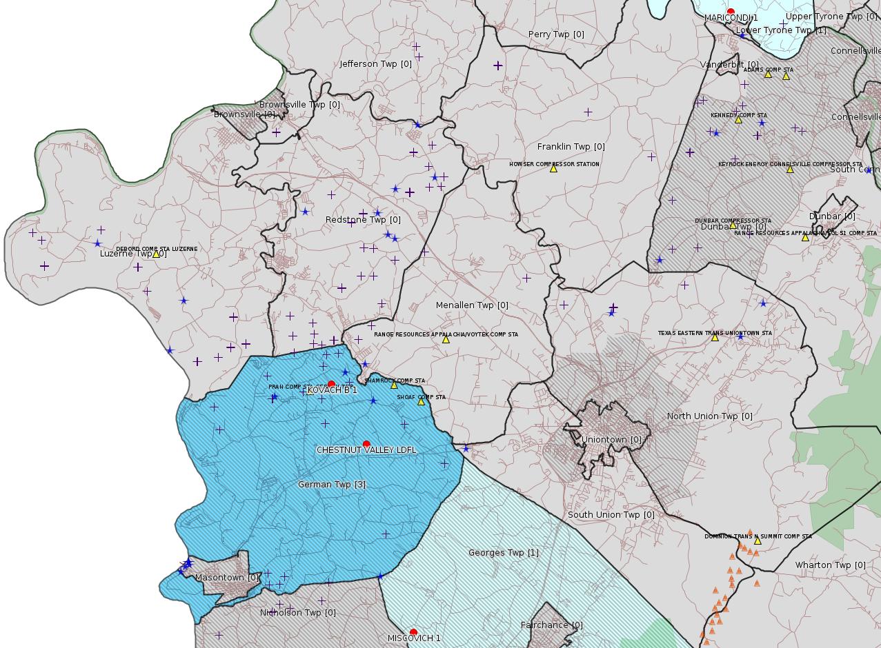
Fayette County Marcellus Shale Permits 12/18/17 - 12/31/17
Click the map to enlarge
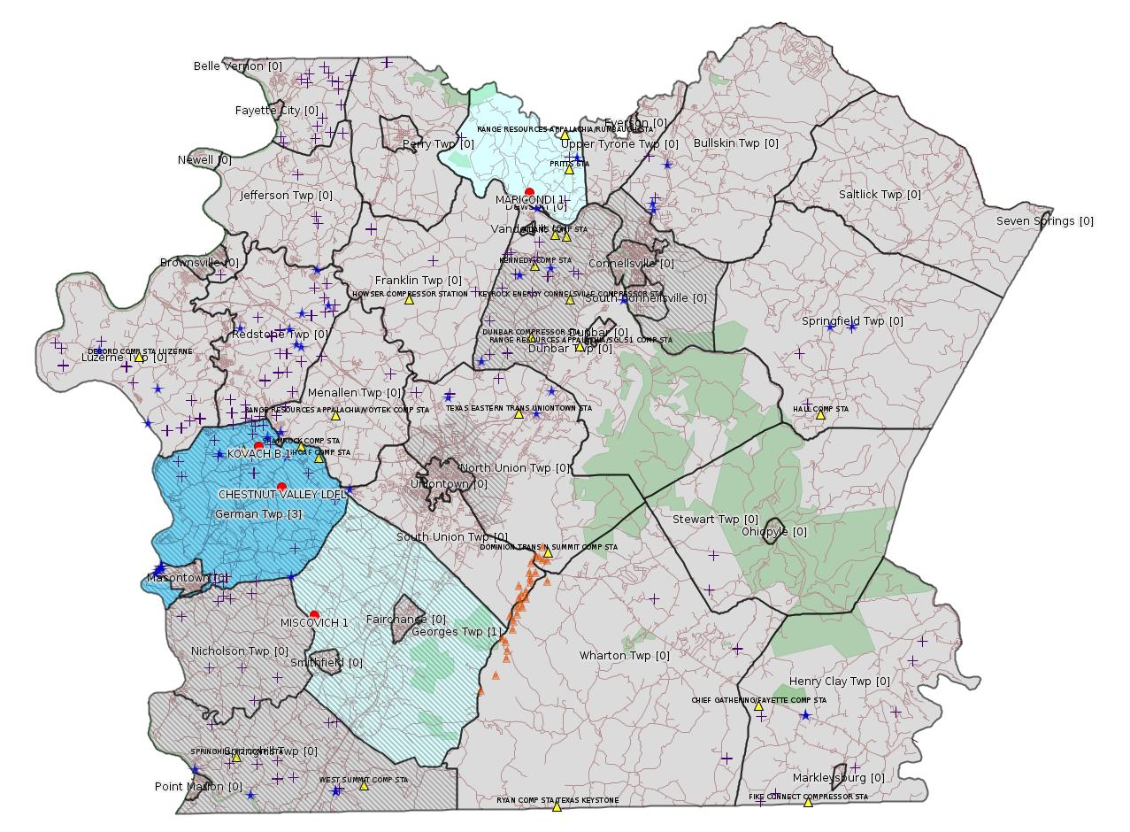
Map
Key
Red dots: items in this permit list with an exact location.
Blue stars: Marcellus Gas Well Water Sources.
Municipality shading: number of "facilities", with each well counting separately
(includes the red dots):
Red dots: items in this permit list with an exact location.
Blue stars: Marcellus Gas Well Water Sources.
Municipality shading: number of "facilities", with each well counting separately
(includes the red dots):
gray: 0
pale turquoise: 1
turquoise: 2
pale blue: 3
middle blue: 4
dark blue: 5
dark purple: 8
purple: 19
(Color coding may differ from one issue to the next.)
(Note if a project spans multiple municipalities -- e.g. a pipeline -- it will show in the count for each municipality.)
The number of facilities also follows the municipality name in brackets.
Municipality counts are based on the way the permit is listed by DEP; DEP has been known to get a municipality wrong.
Locations in brackets identify a precise location used to locate a surrogate for the actual site being permitted (e.g. locating a well pad or pipeline by the known location of a well.) Locations labeled beginning with "~" and ending in "[?]" are approximate and speculative based on inferences using on-line property and lease records. These are marked in the text as "[Approximate, Speculative]
Cross-hatching: Environmental Justice Areas
Yellow triangles: Compressor Stations
Orange triangles: Storage Field Wells (currently Dominion North Summit Storage Field)
Crosses: SPUD Unconventional well permits
Green: "Natural areas", e.g. state game lands, state forests
Yellow triangles: Compressor Stations
Orange triangles: Storage Field Wells (currently Dominion North Summit Storage Field)
Crosses: SPUD Unconventional well permits
Green: "Natural areas", e.g. state game lands, state forests
More Maps
 |
Source: Pennsylvania Bulletin
[No Activity]
-------------------------
Source: eNOTICE (+ PA Oil and Gas Mapping, Well Pad Report.) Well Details via Data Portal Services: Oil and Gas Wells All (ID: 3).
Please see the Disclaimer below regarding Parcel Id data.
[Conventional Well:]
Authorization ID: 1141957
Permit number: 051-21434
Site: MARICONDI 1 OG WELL
Client: RANGE RESOURCES APPALACHIA LLC
Authorization type: Drill & Operate Well Permit Inactive Status
Application type: New
Authorization is for: FACILITY
Date received: 04/25/2015
Status: Denied on 12/19/2017
Permit Decision Guarantee Applies?: No
Sub-Facilities for Authorization:
Sub-Facility ID Sub-Facility Name Description
569358 MARICONDI 1 Well
Permit Review Notes:
Date Review Note
12/19/2017 Application has been deemed to be technically deficient and has been denied.
12/19/2017 Application has been deemed to be technically deficient and has been denied.
12/19/2017 The technical review and decision review are complete and either the permit decision and/or permit issuance are forthcoming.
6/22/2016 The permit application package is complete, has been accepted, and is undergoing technical review.
<http://www.ahs.dep.pa.gov/eFACTSWeb/searchResults_singleAuth.aspx?AuthID=1141957>
Site Programs:
Oil & Gas
Municipalities:
Lower Tyrone Twp, Fayette County
Well Details:
Permit Number: 051-21434
Well Name: MARICONDI 1
Unconventional Well: N
Well Configuration: Vertical Well
Well Type: GAS
Well Status: Active
Coal Association: NonCoal
Conservation Well: N
Primary Facility ID: 571234
Site ID: 555332
Site Name: MARICONDI 1 OG WELL
Well Pad ID: 0
Well Pad Name:
Storage Field:
Operator: RANGE RESOURCES APPALACHIA LLC
Operator Number: OGO-60915
Permit Date: 2002-02-13
Permit Date Expires: 2003-02-13
SPUD Date: 2002-02-21
Date Plugged:
UIC ID:
UIC Type:
Surface Elevation: 975
County: Fayette
Municipality: Lower Tyrone Twp
Location: 40.05393,-79.661847
Map URL: <http://www.openstreetmap.org/?mlat=40.05393&mlon=-79.661847#map=15/40.05393/-79.661847>
Presumed Parcel Id: 18080076
[See Notes.]
[Conventional Well:]
Authorization ID: 1141971
Permit number: 051-23289
Site: MISCOVICH 1 OG WELL
Client: RANGE RESOURCES APPALACHIA LLC
Authorization type: Drill & Operate Well Permit Inactive Status
Application type: New
Authorization is for: FACILITY
Date received: 04/25/2016
Status: Denied on 12/19/2017
Permit Decision Guarantee Applies?: No
Sub-Facilities for Authorization:
Sub-Facility ID Sub-Facility Name Description
921218 MISCOVICH 1 Well
Permit Review Notes:
Date Review Note
12/19/2017 Application has been deemed to be technically deficient and has been denied.
12/19/2017 Application has been deemed to be technically deficient and has been denied.
12/19/2017 The technical review and decision review are complete and either the permit decision and/or permit issuance are forthcoming.
6/22/2016 The permit application package is complete, has been accepted, and is undergoing technical review.
<http://www.ahs.dep.pa.gov/eFACTSWeb/searchResults_singleAuth.aspx?AuthID=1141971>
Site Programs:
Oil & Gas
Municipalities:
Georges Twp [an Environmental Justice Area], Fayette County
Well Details:
Permit Number: 051-23289
Well Name: MISCOVICH 1
Unconventional Well: N
Well Configuration: Vertical Well
Well Type: COMB. OIL&GAS
Well Status: Active
Coal Association: Coal
Conservation Well: N
Primary Facility ID: 680422
Site ID: 672183
Site Name: MISCOVICH 1 OG WELL
Well Pad ID: 0
Well Pad Name:
Storage Field:
Operator: RANGE RESOURCES APPALACHIA LLC
Operator Number: OGO-60915
Permit Date: 2006-06-05
Permit Date Expires: 2007-06-05
SPUD Date: 2006-10-19
Date Plugged:
UIC ID:
UIC Type:
Surface Elevation: 1170
County: Fayette
Municipality: Georges Twp
Location: 39.827222,-79.817345
Map URL: <http://www.openstreetmap.org/?mlat=39.827222&mlon=-79.817345#map=15/39.827222/-79.817345>
Presumed Parcel Id: 14110062
[Possibly off-topic:]
Authorization ID: 1202153
Permit number: 100419
Site: CHESTNUT VALLEY LDFL
Client: ADVANCED DSPL SVC CHESTNUT VALLEY LDFL INC
Authorization type: Minor Modification to an Existing Fac
Application type: Modification
Authorization is for: FACILITY
Date received: 10/11/2017
Status: Pending
Permit Decision Guarantee Applies?: Yes
Permit Decision Guarantee status: ACTIVE
Sub-Facilities for Authorization:
Sub-Facility ID Sub-Facility Name Description
212043 J&J LANDFILL Landfill
<http://www.ahs.dep.pa.gov/eFACTSWeb/searchResults_singleAuth.aspx?AuthID=1202153>
Site Programs:
Air Quality
Clean Water
Environmental Cleanup & Brownfields
Mining
Radiation Protection
Waste Management
Water Planning and Conservation
Municipalities:
German Twp [an Environmental Justice Area], Fayette County
Location: 39.896765,-79.838766 <http://osm.org/go/ZWpP0~XK--?m=>
Presumed Parcel Id: 15280012
[Possibly off-topic:]
Authorization ID: 1204807
Permit number: 100419
Site: CHESTNUT VALLEY LDFL
Client: ADVANCED DSPL SVC CHESTNUT VALLEY LDFL INC
Authorization type: Landfill Pmt Final Construction Certification Form 37
Application type: Modification
Authorization is for: FACILITY
Date received: 10/31/2017
Status: Pending
Permit Decision Guarantee Applies?: Yes
Permit Decision Guarantee status: ACTIVE
Permit Review Notes:
Date Review Note
12/27/2017 The permit application package is complete, has been accepted, and is undergoing technical review.
<http://www.ahs.dep.pa.gov/eFACTSWeb/searchResults_singleAuth.aspx?AuthID=1204807>
Site Programs:
Air Quality
Clean Water
Environmental Cleanup & Brownfields
Mining
Radiation Protection
Waste Management
Water Planning and Conservation
Municipalities:
German Twp [an Environmental Justice Area], Fayette County
[Location information above.]
Authorization ID: 1210459
Permit number: 051-24640
Site: KOVACH B
Client: CHEVRON APPALACHIA LLC
Authorization type: Drill & Operate Well Permit (Unconventional)
Application type: New
Authorization is for: FACILITY
Date received: 12/15/2017
Status: Pending
Permit Decision Guarantee Applies?: No
Sub-Facilities for Authorization:
Sub-Facility ID Sub-Facility Name Description
1250546 WELLBORE SURFACE HOLE LOCATION Well
<http://www.ahs.dep.pa.gov/eFACTSWeb/searchResults_singleAuth.aspx?AuthID=1210459>
Site Programs:
Oil & Gas
Municipalities:
German Twp [an Environmental Justice Area], Fayette County
Well Details:
Permit Number: 051-24640
Well Name: KOVACH B 1
Unconventional Well: Y
Well Configuration: Vertical Well
Well Type: GAS
Well Status: Active
Coal Association: Coal
Conservation Well: N
Primary Facility ID: 823474
Site ID: 826935
Site Name: KOVACH B
Well Pad ID: 155005
Well Pad Name: KOVACH B
Storage Field:
Operator: CHEVRON APPALACHIA LLC
Operator Number: OGO-39307
Permit Date:
Permit Date Expires:
SPUD Date:
Date Plugged:
UIC ID:
UIC Type:
Surface Elevation: 1278
County: Fayette
Municipality: German Twp
Location: 39.918967,-79.854906
Map URL: <http://www.openstreetmap.org/?mlat=39.918967&mlon=-79.854906#map=15/39.918967/-79.854906>
Presumed Parcel Id: 1511002301
-------------------------
Source: Reuters Commodities: Energy
Natural Gas
| Commodity | Exchange | Currency | Expire | Last Trade | Trade Time | Change | Open | Day's High | Day's Low |
|---|---|---|---|---|---|---|---|---|---|
| NATURAL
GAS CON1 Jan18 |
NYM | USD | 01/29 | 3.07 | 12/31 23:06 | +0.12 | 3.03 | 3.10 | 3.03 |
-------------------------
Notes:
DEP denies very few permits -- certainly with respect to Oil & Gas. The typical reason for a permit denial seems to be failure to respond when DEP raises an issue. The well MARICONDI 1 was inspected on 2016-07-27, Inspection ID 2505312, no violations, and the only comment was "Routine Inspection pryor to approving Inactive Status." It is not clear from eFACTS why there was over a year's delay between the permit received date and the permit review note on 6/22/2016 stating "The permit application package is complete, has been accepted, and is undergoing technical review." Presumably there was some correspondence between DEP and Range Resources that would shed light on what happened here, which would take File Review to reveal. (Circumstances for the well MISCOVICH 1 seem to be exactly the same.)
------------------------
DEP defines an environmental justice area as "any census tract where 20 percent or more individuals live in poverty, and/or 30 percent or more of the population is minority". (See:
<http://www.dep.pa.gov/PublicParticipation/OfficeofEnvironmentalJustice/Pages/default.aspx>). There are supposed to be enhanced public participation requirements for permits in environmental justice areas, but news of this actually ever happening is scarce. In Fayette County, the entirety of Springhill, Nicholson, German, and Georges Townships are environmental justice areas, as well as a large part of Dunbar Township. DEP's policy document on public participation guidelines for environmental justice areas is located here:
<http://www.elibrary.dep.state.pa.us/dsweb/Get/Version-48671/012-0501-002.pdf>
eNOTICE records are likely to list the same permit multiple times, as that permit moves through the DEP process.
Oil & Gas Wells designated with a site a number and the letter H typically designate horizontal wells.
-------------------------
Resources:
Pennsylvania Bulletin: <http://www.pabulletin.com/>
eNOTICE: <http://www.ahs2.dep.state.pa.
DEP Oil and Gas Reports: <http://www.dep.pa.gov/DataandTools/Reports/Oil%20and%20Gas%20Reports/Pages/default.aspx>
DEP Well Details Report: <https://www.paoilandgasreport
Well Details may not show any
information for new permits and will not show permits which have
not yet been issued. Lookup for Well Details is by permit number.
DEP Permits Issued Detail Report:
<http://www.depreportingservic
DEP SPUD (drilling started) Report:
<http://www.depreportingservices.state.pa.us/ReportServer/Pages/ReportViewer.aspx?/Oil_Gas/Spud_External_Data>
DEP Oil and Gas Compliance Report:
<http://www.depreportingservices.state.pa.us/ReportServer/Pages/ReportViewer.aspx?/Oil_Gas/OG_Compliance>
DEP PA Oil & Gas Mapping:
<http://www.depgis.state.pa.us/PaOilAndGasMapping>
Data Portal Services Directory [Technical]
<http://www.depgis.state.pa.us/arcgis/rest/services>
Query: Oil and Gas Wells All (ID: 3) [Technical]:
<http://www.depgis.state.pa.us/arcgis/rest/services/OilGas/OilGasAllStrayGas/MapServer/3/query?where=&text=&objectIds=&time=&geometry=&geometryType=esriGeometryEnvelope&inSR=&spatialRel=esriSpatialRelIntersects&relationParam=&outFields=OBJECTID%2CPERMIT_NUMBER%2CWELL_NAME%2COPERATOR%2COPERATOR_NUMBER%2CWELL_TYPE%2CWELL_TYPE_CODE%2CWELL_STATUS%2CWELL_STATUS_CODE%2CPERMIT_DATE%2CPERMIT_DATE_EXPIRES%2CSPUD_DATE%2CCONSERVATION_IND%2CCOUNTY%2CCOUNTY_ID%2CMUNICIPALITY%2CMUNICIPALITY_TYPE%2CMUNICIPALITY_CODE%2CLATITUDE%2CLONGITUDE%2CPRMRY_FID%2CUNCONVENTIONAL_IND%2CSURFACE_ELEVATION%2CWELL_CONFIG_CODE%2CCOAL_IND%2CWELL_PAD_NAME%2CSHAPE%2CDATE_PLUGGED%2CWELL_PAD_ID%2CUIC_ID%2CUIC_TYPE_DESCRIPTION%2CSTORAGE_FIELD_NAME%2CSITE_ID%2CSITE_NAME&returnGeometry=true&returnTrueCurves=false&maxAllowableOffset=&geometryPrecision=&outSR=&returnIdsOnly=false&returnCountOnly=false&orderByFields=&groupByFieldsForStatistics=&outStatistics=&returnZ=false&returnM=false&gdbVersion=&returnDistinctValues=false&resultOffset=&resultRecordCount=&f=html>
(Be sure to enter a Where clause in SQL format. Dates are in milliseconds since midnight 1/1/1970).
DEP Oil and Gas Electronic Notifications
<http://www.depreportingservices.state.pa.us/ReportServer?/Oil_Gas/OG_Notifications>
DEP Oil and Gas Well Pad Report
<http://www.depreportingservices.state.pa.us/ReportServer?/Oil_Gas/Well_Pads>
Fayette County Assessment Office Search For Tax Records:
<http://property.co.fayette.pa.us/search.aspx>
Pennsylvania Spatial Data Access:
<http://www.pasda.psu.edu/default.asp>
DEP Spatial Data Repository:
<ftp://www.pasda.psu.edu/pub/pasda/dep/>
National Response Center:
<http://www.nrc.uscg.mil/>
EPA-Echo: <http://www.epa-echo.gov/echo/
FERC citizen involvement: <http://www.ferc.gov/for-citiz
To receive E-mail notification of
all documents filed in a FERC docket, see:
<http://www.ferc.gov/docs-filing/esubscription.asp >
<http://www.ferc.gov/docs-fili
Follow the directions and enter the docket number to subscribe to.
Township Supervisors receive information regarding Erosion & Sedimentation permits, and these records may be reviewable at township municipal offices.
DEP permits are reviewable through the File Review process, for application to do file review see: <http://www.portal.state.pa.us/portal/server.pt/community/southwest_regional_office/13775/file_review/593164>
Environmental Hearing Board: <http://ehb.courtapps.com/publ
PA DEP Environmental Policy Comment System:
<http://www.ahs.dep.pa.gov/eComment/>
Federal Register Environment: <https://www.federalregister.g
Browsing of recent comment
opportunities for federal agencies, e.g. EPA. Click "sign up" to
subscribe to daily E-mails of new document listings.
SkyTruth Fayette County Drilling Alerts: <http://frack.skytruth.org/pen
U.S. Army Corps of Engineers, Pittsburgh District, Public Notices:
<http://www.lrp.usace.army.mil/Missions/Regulatory/Public-Notices/>
EPA Pennsylvania Public Notices: <http://www2.epa.gov/aboutepa/epa-pennsylvania#notice>
Marcellus Shale waste disposal
injection wells in Pennsylvania are regulated directly by EPA, not
DEP. Notice of any new permit applications will appear at the
above web address. I'm not aware of any subscription service
to be notified of such applications. I'm not aware of any
Marcellus Shale waste disposal injection wells in Fayette County
(yet ...) but we need to monitor this page for future
applications.
Energy Assurance Daily: <http://www.oe.netl.doe.gov/ead.aspx>
Daily newsletter from the US
Department of Energy about events relating to energy. The Natural
Gas section has information about pipelines.
-------------------------
Disclaimers:
This compilation from the above sources was done by hand using copy and paste and may omit relevant permits.
Parcel data is provided via the tax records search web page offered by the Fayette County Assessment Office (http://property.co.fayette.pa.us/). Presumed Parcel Id links are subject to availability provided by that agency and associated web sites. Presumed Parcel Ids are determined as the mapped parcel containing a given latitude and longitude, are a best effort determination which is subject to error, and are not official. In cases where a facility is leased and there is a separate parcel id for the lease, if this parcel id is not separately mapped, the parcel id shown will be the id for the enclosing parcel. Parcel owners may be surface owners only and may or may not have any relationship to oil & gas facilities.
Does not currently include water supply permits. Does not include landfill permits even though many such are for Marcellus Shale waste. (It is not possible at this time to distinguish which landfill permits are for Marcellus Shale waste and which are not without doing File Review for each permit.)
Erosion & Sedimentation permit records do not currently include latitude and longitude. Where I am publishing latitude and longitude with E&S permits it is by inferring an associated well permit and using published latitude and longitude for the well. It is possible I may be inferring the wrong well site.
Municipalities are shown from eFACTS records on the DEP web site. The DEP has been known to list a municipality incorrectly.