The Harmed Success Stories Concepts How To What Is Commentary
Pennsylvania Oil & Gas Wells Recently Issued or Pending in
ePermitting
DEP Open Data Portal Data Repository
ArcGIS REST Services Directory
Home > services > OilGas > OilGasAllStrayGasEGSP (MapServer) > GDC.OG_WELL_EPERMIT_AUTHS > query
<https://gis.dep.pa.gov/depgisprd/rest/services/OilGas/OilGasAllStrayGasEGSP/MapServer/58/query?where=AUTH_ID+is+not+null&text=&objectIds=&time=&geometry=&geometryType=esriGeometryEnvelope&inSR=&spatialRel=esriSpatialRelIntersects&relationParam=&outFields=*&returnGeometry=true&returnTrueCurves=false&maxAllowableOffset=&geometryPrecision=&outSR=&having=&returnIdsOnly=false&returnCountOnly=false&orderByFields=PERMIT_NUMBER+desc&groupByFieldsForStatistics=&outStatistics=&returnZ=false&returnM=false&gdbVersion=&historicMoment=&returnDistinctValues=false&resultOffset=&resultRecordCount=&queryByDistance=&returnExtentOnly=false&datumTransformation=¶meterValues=&rangeValues=&quantizationParameters=&featureEncoding=esriDefault&f=pjson>
Note: Wells are listed below by Permit number descending. This should place all wells for a given county together, with the newest first, counties in reverse alphabetical order. Wells will disappear from this list when the authorization record is no longer Pending, e.g. the permit has been Issued or Withdrawn or (don't hold your breath!) Denied.
A plat should be available for each well (except for Renewals) by following the Public_Permit_Review link, clicking on the UDOW Well Plat link, and clicking on the Download button.
Contents
Data as of 2026-07-13:
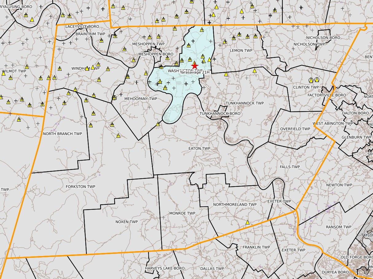
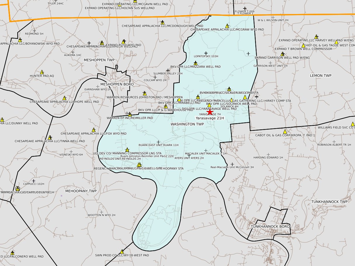
Wyoming County
EXPAND OPER LLC MCGRAW 25H Drill & Operate Well Permit (Unconventional)
EXPAND OPER LLC MCGRAW 24HC Drill & Operate Well Permit (Unconventional)
Westmoreland County
EQT CHAP LLC Dermotta B 113H Drill & Operate Well Permit (Unconventional)
EQT CHAP LLC Dermotta B 111H Drill & Operate Well Permit (Unconventional)
EQT CHAP LLC Dermotta B 109H Drill & Operate Well Permit (Unconventional)
EQT CHAP LLC Dermotta B 107H Drill & Operate Well Permit (Unconventional)
EQT CHAP LLC Dermotta B 105H Drill & Operate Well Permit (Unconventional)
EQT CHAP LLC Dermotta B 103H Drill & Operate Well Permit (Unconventional)
EQT CHAP LLC Dermotta B 101H Drill & Operate Well Permit (Unconventional)
CNX GAS CO LLC CNX MAM14LHSU Drill & Operate Well Permit (Unconventional) Modification Issued on 2026-06-30
CNX GAS CO LLC CNX MAM14KHSU Drill & Operate Well Permit (Unconventional) Modification Issued on 2026-06-30
CNX GAS CO LLC CNX MAM14JHSU Drill & Operate Well Permit (Unconventional) Modification Issued on 2026-06-30
CNX GAS CO LLC CNX MAM14MHSU Drill & Operate Well Permit (Unconventional) Modification Issued on 2026-06-30
Washington County
RANGE RESOURCES APPALACHIA LLC HARRIS MICHAEL 11116 5H Drill & Operate Well Permit (Unconventional)
RANGE RESOURCES APPALACHIA LLC HARRIS MICHAEL 11116 4H Drill & Operate Well Permit (Unconventional)
RANGE RESOURCES APPALACHIA LLC HARRIS MICHAEL 11116 3H Drill & Operate Well Permit (Unconventional)
RANGE RESOURCES APPALACHIA LLC HARRIS MICHAEL 11116 2H Drill & Operate Well Permit (Unconventional)
RANGE RESOURCES APPALACHIA LLC HARRIS MICHAEL 11116 1H Drill & Operate Well Permit (Unconventional)
CNX GAS CO LLC Collins WFN13FHSM Drill & Operate Well Permit (Unconventional) Issued on 2026-07-02
CNX GAS CO LLC Collins WFN13EHSM Drill & Operate Well Permit (Unconventional) Issued on 2026-07-02
CNX GAS CO LLC Collins WFN13DHSM Drill & Operate Well Permit (Unconventional) Issued on 2026-07-02
CNX GAS CO LLC Collins WFN13CHSM Drill & Operate Well Permit (Unconventional) Issued on 2026-07-02
CNX GAS CO LLC Collins WFN13BHSM Drill & Operate Well Permit (Unconventional) Issued on 2026-07-02
CNX GAS CO LLC Collins WFN13AHSM Drill & Operate Well Permit (Unconventional) Issued on 2026-07-02
RANGE RESOURCES APPALACHIA LLC YONKER GEORGE 11360 16H Drill & Operate Well Permit (Unconventional) Issued on 2026-07-02
RANGE RESOURCES APPALACHIA LLC YONKER GEORGE 11360 15H Drill & Operate Well Permit (Unconventional) Issued on 2026-07-02
RANGE RESOURCES APPALACHIA LLC WYLIE DENNIS 17563 7H Drill & Operate Well Permit (Unconventional) Modification
RANGE RESOURCES APPALACHIA LLC WYLIE DENNIS 17563 6H Drill & Operate Well Permit (Unconventional) Modification
RANGE RESOURCES APPALACHIA LLC FOLTZ LOWRY 11923 6H Drill & Operate Well Permit (Unconventional) Modification Issued on 2026-06-30
RANGE RESOURCES APPALACHIA LLC FOLTZ LOWRY 11923 5H Drill & Operate Well Permit (Unconventional) Modification Issued on 2026-06-30
Tioga County
SENECA RESOURCES CO LLC Lingle 1102 West 239HU 54138 Drill & Operate Well Permit (Unconventional)
SENECA RESOURCES CO LLC Lingle 1102 West 193HU 54050 Drill & Operate Well Permit (Unconventional)
SENECA RESOURCES CO LLC Lingle 1102 West 43HU 53624 Drill & Operate Well Permit (Unconventional)
SENECA RESOURCES CO LLC Lingle 1102 West 42HU 53623 Drill & Operate Well Permit (Unconventional)
SENECA RESOURCES CO LLC Lingle 1102 West 41HU 53622 Drill & Operate Well Permit (Unconventional)
SENECA RESOURCES CO LLC Bathgate 766 214HU 54103 Drill & Operate Well Permit (Unconventional)
JKLM ENERGY LLC Belz 2001 53HU Drill & Operate Well Permit (Unconventional) Modification
JKLM ENERGY LLC Belz 2001 55HU Drill & Operate Well Permit (Unconventional) Modification
SENECA RESOURCES CO LLC DCNR 007 Pad D 248HU 54081 Drill & Operate Well Permit (Unconventional) Modification
Lycoming County
PA GEN ENERGY CO LLC COP Tract 726 Pad F 2871 Drill & Operate Well Permit (Unconventional)
PA GEN ENERGY CO LLC COP Tract 726 Pad F 2865 Drill & Operate Well Permit (Unconventional)
PA GEN ENERGY CO LLC COP Tract 726 Pad F 2864 Drill & Operate Well Permit (Unconventional)
PA GEN ENERGY CO LLC COP Tract 726 Pad F 2863 Drill & Operate Well Permit (Unconventional)
PA GEN ENERGY CO LLC COP Tract 726 Pad F 2861 Drill & Operate Well Permit (Unconventional)
PA GEN ENERGY CO LLC COP Tract 726 Pad F 2860 Drill & Operate Well Permit (Unconventional)
FORMENTERA OPR LLC Strouse 1H Drill & Operate Well Permit (Unconventional) Renewal
Indiana County
INR OPR LLC Anegada 12HM Drill & Operate Well Permit (Unconventional)
INR OPR LLC Anegada 10HM Drill & Operate Well Permit (Unconventional)
Greene County
CNX GAS CO LLC BLAIR RHL22LHSM Drill & Operate Well Permit (Unconventional) Renewal
CNX GAS CO LLC BLAIR RHL22MHSM Drill & Operate Well Permit (Unconventional) Renewal
EQT PROD CO Clemente 32H Drill & Operate Well Permit (Unconventional) Renewal Issued on 2026-07-02
RICE DRILLING B LLC COSGRAY 9 Drill & Operate Well Permit (Unconventional) Modification
Butler County
LAUREL MOUNTAIN PRODUCTION CMB Well Pad 10H Drill & Operate Well Permit (Unconventional)
LAUREL MOUNTAIN PRODUCTION CMB Well Pad 8H Drill & Operate Well Permit (Unconventional)
LAUREL MOUNTAIN PRODUCTION CMB Well Pad 6H Drill & Operate Well Permit (Unconventional)
LAUREL MOUNTAIN PRODUCTION CMB Well Pad 4H Drill & Operate Well Permit (Unconventional)
LAUREL MOUNTAIN PRODUCTION CMB Well Pad 2H Drill & Operate Well Permit (Unconventional)
Bradford County
EXPAND OPER LLC BURNS 5HC Drill & Operate Well Permit (Unconventional)
EXPAND OPER LLC BURNS 4HC Drill & Operate Well Permit (Unconventional)
EXPAND OPER LLC BURNS 3HC Drill & Operate Well Permit (Unconventional)
EXPAND OPER LLC RAIMO 101HC Drill & Operate Well Permit (Unconventional)
EXPAND OPER LLC RAIMO 3HC Drill & Operate Well Permit (Unconventional)
EXPAND OPER LLC STONE 22HC Drill & Operate Well Permit (Unconventional) Issued on 2026-07-07
EXPAND OPER LLC STONE 21HC Drill & Operate Well Permit (Unconventional) Issued on 2026-07-01
EXPAND OPER LLC JANNEY 104HC Drill & Operate Well Permit (Unconventional)
EXPAND OPER LLC SGL-12 G 104HC Drill & Operate Well Permit (Unconventional)
EXPAND OPER LLC BENNETT 122HC Drill & Operate Well Permit (Unconventional) Issued on 2026-06-30
EXPAND OPER LLC BENNETT 23HC Drill & Operate Well Permit (Unconventional) Issued on 2026-06-30
Armstrong County
SNYDER BROS INC Brestensky 9H Drill & Operate Well Permit (Unconventional)
Wyoming County