The Harmed Success Stories Concepts How To What Is Commentary
Fayette County Marcellus Shale Permits 1/15/18 - 1/28/18
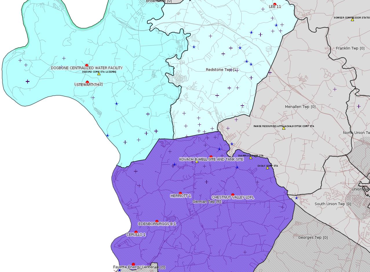
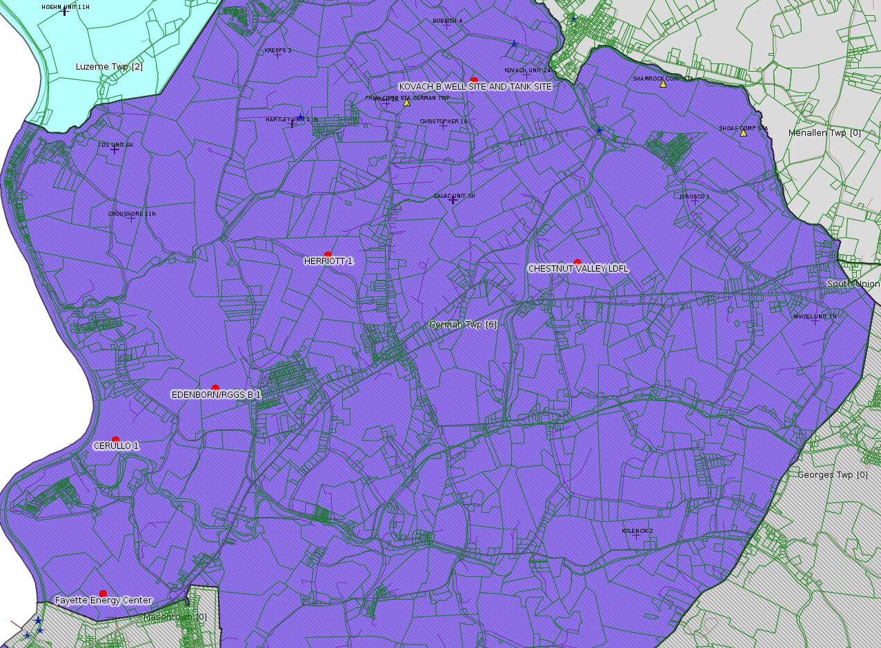
Click the map to enlarge
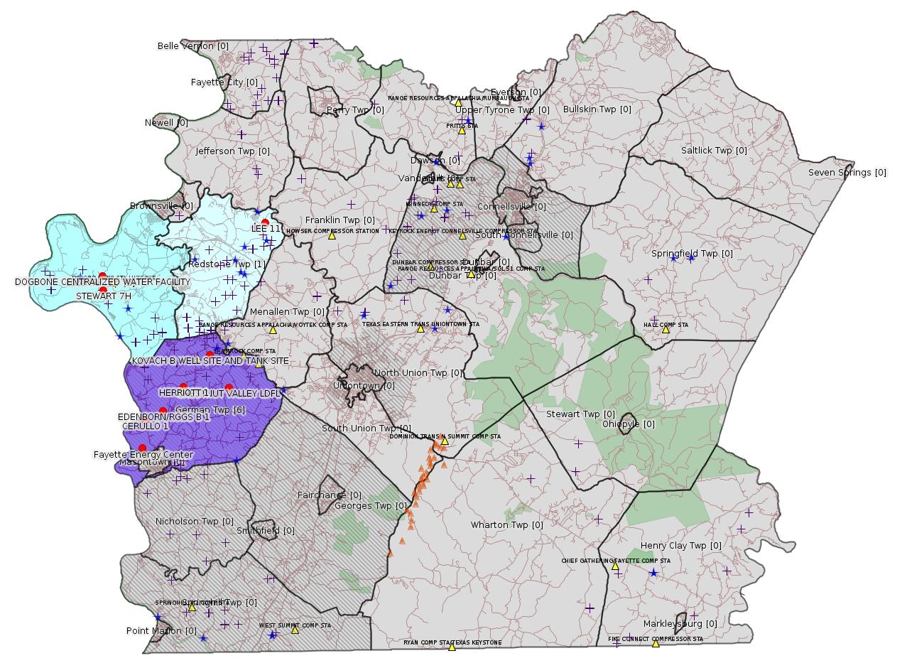
Map
Key
Red dots: items in this permit list with an exact location.
Blue stars: Marcellus Gas Well Water Sources.
Municipality shading: number of "facilities", with each well counting separately
(includes the red dots):
Red dots: items in this permit list with an exact location.
Blue stars: Marcellus Gas Well Water Sources.
Municipality shading: number of "facilities", with each well counting separately
(includes the red dots):
gray: 0
pale turquoise: 1
turquoise: 2
pale blue: 3
middle blue: 4
dark blue: 5
dark purple: 6
purple: 14
(Color coding may differ from one issue to the next.)
(Note if a project spans multiple municipalities -- e.g. a pipeline -- it will show in the count for each municipality.)
The number of facilities also follows the municipality name in brackets.
Municipality counts are based on the way the permit is listed by DEP; DEP has been known to get a municipality wrong.
Locations in brackets identify a precise location used to locate a surrogate for the actual site being permitted (e.g. locating a well pad or pipeline by the known location of a well.) Locations labeled beginning with "~" and ending in "[?]" are approximate and speculative based on inferences using on-line property and lease records. These are marked in the text as "[Approximate, Speculative]
Cross-hatching: Environmental Justice Areas
Yellow triangles: Compressor Stations
Orange triangles: Storage Field Wells (currently Dominion North Summit Storage Field)
Crosses: SPUD Unconventional well permits
Green: "Natural areas", e.g. state game lands, state forests
Yellow triangles: Compressor Stations
Orange triangles: Storage Field Wells (currently Dominion North Summit Storage Field)
Crosses: SPUD Unconventional well permits
Green: "Natural areas", e.g. state game lands, state forests
More Maps
 |
 |
 |
Source: Pennsylvania Bulletin
[No Activity]
-------------------------
Source: eNOTICE (+ PA Oil and Gas Mapping, Well Pad Report.) Well Details via Data Portal Services: Oil and Gas Wells All (ID: 3).
Please see the Disclaimer below regarding Parcel Id data.
Authorization ID: 1179749
Permit number: WMGR123SW025
Site: DOGBONE CENTRALIZED WATER FACILITY
Client: CHEVRON APPALACHIA, LLC
Authorization type: RW General Permit Processing Registration
Application type: New
Authorization is for: FACILITY
Date received: 04/25/2017
Status: Pending
Permit Decision Guarantee Applies?: Yes
Permit Decision Guarantee status: VOID
Sub-Facilities for Authorization:
Sub-Facility ID Sub-Facility Name Description
1232831 DOGBONE CENTRALIZED WATER FACILITY Processing Facility
Permit Review Notes:
Date Review Note
7/24/2017 Applicant has been issued a deficiency letter. If applicable, this application no longer qualifies for the Permit Decision Guarantee.
6/5/2017 Applicant has been issued a deficiency letter. If applicable, this application no longer qualifies for the Permit Decision Guarantee.
<http://www.ahs.dep.pa.gov/eFACTSWeb/searchResults_singleAuth.aspx?AuthID=1179749>
Site Programs:
Waste Management
Municipalities:
Luzerne Twp, Fayette County
Location: 39.972496,-79.946939 <http://osm.org/go/ZWpZaULM--?m=>
Municipalities: Luzerne Twp
Presumed Parcel Id: 19160040
Fayette County Act 14 Notification: <http://faymarwatch.org/documents/SKM_554e17050309530.pdf>
Chevron Topographic Map Including "Proposed" Pipelines: <http://faymarwatch.org/documents/ZHB_17-41_121317_topo.pdf>
[See Notes.]
[Possibly Off-Topic:]
Authorization ID: 1202153
Permit number: 100419
Site: CHESTNUT VALLEY LDFL
Client: ADVANCED DSPL SVC CHESTNUT VALLEY LDFL INC
Authorization type: Minor Modification to an Existing Fac
Application type: Modification
Authorization is for: FACILITY
Date received: 10/11/2017
Status: Pending
Permit Decision Guarantee Applies?: Yes
Permit Decision Guarantee status: VOID
Sub-Facilities for Authorization:
Sub-Facility ID Sub-Facility Name Description
212043 J&J LANDFILL Landfill
<http://www.ahs.dep.pa.gov/eFACTSWeb/searchResults_singleAuth.aspx?AuthID=1202153>
Site Programs:
Air Quality
Clean Water
Environmental Cleanup & Brownfields
Mining
Radiation Protection
Waste Management
Water Planning and Conservation
Municipalities:
German Twp [an Environmental Justice Area], Fayette County
Location: 39.896765,-79.838766 <http://osm.org/go/ZWpP0~XK--?m=>
Presumed Parcel Id: 15280012
Authorization ID: 1203103
Permit number: 051-24639
Site: STEWART WELL SITE ESCGP-2 EXPEDITED
Client: CHEVRON APPALACHIA LLC
Authorization type: Drill & Operate Well Permit (Unconventional)
Application type: New
Authorization is for: FACILITY
Date received: 10/17/2017
Status: Pending
Permit Decision Guarantee Applies?: No
Sub-Facilities for Authorization:
Sub-Facility ID Sub-Facility Name Description
1246056 WELLBORE SURFACE HOLE LOCATION Well
Permit Review Notes:
Date Review Note
1/4/2018 Applicant has been issued a deficiency letter. If applicable, this application no longer qualifies for the Permit Decision Guarantee.
1/4/2018 The technical review and decision review are complete and either the permit decision and/or permit issuance are forthcoming.
11/15/2017 The permit application package is complete, has been accepted, and is undergoing technical review.
<http://www.ahs.dep.pa.gov/eFACTSWeb/searchResults_singleAuth.aspx?AuthID=1203103>
Site Programs:
Oil & Gas
Municipalities:
Luzerne Twp, Fayette County
Well Details:
Permit Number: 051-24639
Well Name: STEWART 7H
Unconventional Well: Y
Well Configuration: Horizontal Well
Well Type: GAS
Well Status: Active
Coal Association: Coal
Conservation Well: N
Primary Facility ID: 822072
Site ID: 788124
Site Name: STEWART WELL SITE ESCGP-2 EXPEDITED
Well Pad ID: 152396
Well Pad Name: STEWART
Storage Field:
Operator: CHEVRON APPALACHIA LLC
Operator Number: OGO-39307
Permit Date: 2018-01-26
Permit Date Expires: 2019-01-26
SPUD Date:
Date Plugged:
UIC ID:
UIC Type:
Surface Elevation: 1140
County: Fayette
Municipality: Luzerne Twp
Location: 39.962917,-79.946617
Map URL: <http://www.openstreetmap.org/?mlat=39.962917&mlon=-79.946617#map=15/39.962917/-79.946617>
Presumed Parcel Id: 19250010
[See Notes.]
Authorization ID: 1212314
Permit number: 051-24639
Site: STEWART WELL SITE ESCGP-2 EXPEDITED
Client: CHEVRON APPALACHIA LLC
Authorization type: Alt Method of Equipping, Casing, or Venting Well
Application type: New
Authorization is for: FACILITY
Date received: 12/27/2017
Status: Issued on 1/17/2018
Permit Decision Guarantee Applies?: Yes
Permit Decision Guarantee status: ACTIVE
Sub-Facilities for Authorization:
Sub-Facility ID Sub-Facility Name Description
1246056 WELLBORE SURFACE HOLE LOCATION Well
Permit Review Notes:
Date Review Note
1/17/2018 The technical review and decision review are complete and either the permit decision and/or permit issuance are forthcoming.
1/4/2018 The permit application package is complete, has been accepted, and is undergoing technical review.
<http://www.ahs.dep.pa.gov/eFACTSWeb/searchResults_singleAuth.aspx?AuthID=1212314>
Site Programs:
Oil & Gas
Municipalities:
Luzerne Twp, Fayette County
[Well Details above.]
Authorization ID: 1210331
Permit number: ESX17-051-0003
Site: KOVACH B WELL SITE AND TANK SITE ESCGP ESX17-051-0003
Client: CHEVRON APPALACHIA LLC
Authorization type: Expedited E&S Stormwater General Permit 1
Application type: New
Authorization is for: SITE
Date received: 12/12/2017
Status: Pending
Permit Decision Guarantee Applies?: Yes
Permit Decision Guarantee status: VOID
Permit Review Notes:
Date Review Note
1/18/2018 Applicant has been issued a deficiency letter. If applicable, this application no longer qualifies for the Permit Decision Guarantee.
1/16/2018 The permit application package is complete, has been accepted, and is undergoing technical review.
<http://www.ahs.dep.pa.gov/eFACTSWeb/searchResults_singleAuth.aspx?AuthID=1210331>
Site Programs:
Municipalities:
German Twp [an Environmental Justice Area], Fayette County
Location: 39.918939,-79.854611
Well Pad ID: 155005
Wells on this Pad:
051-24640 KOVACH B 1
Presumed Parcel Id: 1511002301
New:
Authorization ID: 1213815
Permit number: 051-24649
Site: HERRIOTT
Client: CHEVRON APPALACHIA LLC
Authorization type: Drill & Operate Well Permit (Unconventional)
Application type: New
Authorization is for: FACILITY
Date received: 01/18/2018
Status: Pending
Permit Decision Guarantee Applies?: No
Sub-Facilities for Authorization:
Sub-Facility ID Sub-Facility Name Description
1252289 WELLBORE SURFACE HOLE LOCATION Well
Permit Review Notes:
Date Review Note
1/19/2018 The permit application package is complete, has been accepted, and is undergoing technical review.
<http://www.ahs.dep.pa.gov/eFACTSWeb/searchResults_singleAuth.aspx?AuthID=1213815>
Site Programs:
Oil & Gas
Municipalities:
German Twp [an Environmental Justice Area], Fayette County
Well Details:
Permit Number: 051-24649
Well Name: HERRIOTT 1
Unconventional Well: Y
Well Configuration: Vertical Well
Well Type: GAS
Well Status: Active
Coal Association: Coal
Conservation Well: N
Primary Facility ID: 824040
Site ID: 827337
Site Name: HERRIOTT
Well Pad ID: 155082
Well Pad Name: HERRIOTT
Storage Field:
Operator: CHEVRON APPALACHIA LLC
Operator Number: OGO-39307
Permit Date:
Permit Date Expires:
SPUD Date:
Date Plugged:
UIC ID:
UIC Type:
Surface Elevation: 1265
County: Fayette
Municipality: German Twp
Location: 39.898056,-79.877942
Map URL: <http://www.openstreetmap.org/?mlat=39.898056&mlon=-79.877942#map=15/39.898056/-79.877942>
Presumed Parcel Id: 15220125
New:
Authorization ID: 1213817
Permit number: 051-24650
Site: CERULLO
Client: CHEVRON APPALACHIA LLC
Authorization type: Drill & Operate Well Permit (Unconventional)
Application type: New
Authorization is for: FACILITY
Date received: 01/18/2018
Status: Pending
Permit Decision Guarantee Applies?: No
Sub-Facilities for Authorization:
Sub-Facility ID Sub-Facility Name Description
1252291 WELLBORE SURFACE HOLE LOCATION Well
Permit Review Notes:
Date Review Note
1/19/2018 The permit application package is complete, has been accepted, and is undergoing technical review.
<http://www.ahs.dep.pa.gov/eFACTSWeb/searchResults_singleAuth.aspx?AuthID=1213817>
Site Programs:
Oil & Gas
Municipalities:
German Twp [an Environmental Justice Area], Fayette County
Well Details:
Permit Number: 051-24650
Well Name: CERULLO 1
Unconventional Well: Y
Well Configuration: Vertical Well
Well Type: GAS
Well Status: Active
Coal Association: Coal
Conservation Well: N
Primary Facility ID: 824042
Site ID: 827238
Site Name: CERULLO
Well Pad ID: 155068
Well Pad Name: CERULLO
Storage Field:
Operator: CHEVRON APPALACHIA LLC
Operator Number: OGO-39307
Permit Date:
Permit Date Expires:
SPUD Date:
Date Plugged:
UIC ID:
UIC Type:
Surface Elevation: 1063
County: Fayette
Municipality: German Twp
Location: 39.875992,-79.911644
Map URL: <http://www.openstreetmap.org/?mlat=39.875992&mlon=-79.911644#map=15/39.875992/-79.911644>
Presumed Parcel Id: 15190070
New:
Authorization ID: 1213996
Permit number: 051-24651
Site: EDENBORN/RGGS B
Client: CHEVRON APPALACHIA LLC
Authorization type: Drill & Operate Well Permit (Unconventional)
Application type: New
Authorization is for: FACILITY
Date received: 01/19/2018
Status: Pending
Permit Decision Guarantee Applies?: No
Sub-Facilities for Authorization:
Sub-Facility ID Sub-Facility Name Description
1252365 WELLBORE SURFACE HOLE LOCATION Well
Permit Review Notes:
Date Review Note
1/23/2018 The permit application package is complete, has been accepted, and is undergoing technical review.
<http://www.ahs.dep.pa.gov/eFACTSWeb/searchResults_singleAuth.aspx?AuthID=1213996>
Site Programs:
Oil & Gas
Municipalities:
German Twp [an Environmental Justice Area], Fayette County
Well Details:
Permit Number: 051-24651
Well Name: EDENBORN/RGGS B 1
Unconventional Well: Y
Well Configuration: Vertical Well
Well Type: GAS
Well Status: Active
Coal Association: Coal
Conservation Well: N
Primary Facility ID: 824076
Site ID: 827338
Site Name: EDENBORN/RGGS B
Well Pad ID: 155083
Well Pad Name: EDENBORN/RGGS B
Storage Field:
Operator: CHEVRON APPALACHIA LLC
Operator Number: OGO-39307
Permit Date:
Permit Date Expires:
SPUD Date:
Date Plugged:
UIC ID:
UIC Type:
Surface Elevation: 1167
County: Fayette
Municipality: German Twp
Location: 39.882106,-79.895881
Map URL: <http://www.openstreetmap.org/?mlat=39.882106&mlon=-79.895881#map=15/39.882106/-79.895881>
Presumed Parcel Id: 15220014
[Arguably Off-Topic:]
Authorization ID: 1214629
Permit number: 26-00535B
Site: FAYETTE ENERGY FACILITY
Client: DYNEGY FAYETTE II, LLC
Authorization type: Major Facility Plan Approval New Source Performance Std
Application type: Extension
Authorization is for: FACILITY
Date received: 01/18/2018
Status: Pending
Permit Decision Guarantee Applies?: No
Permit Review Notes:
Date Review Note
1/26/2018 The permit application package is complete, has been accepted, and is undergoing technical review.
<http://www.ahs.dep.pa.gov/eFACTSWeb/searchResults_singleAuth.aspx?AuthID=1214629>
Site Programs:
Air Quality
Waste Management
Water Planning and Conservation
Municipalities:
German Twp [an Environmental Justice Area], Fayette County
Masontown Boro, Fayette County
Location: 39.857412,-79.913878 <http://osm.org/go/ZWpM9Ua6--?m=>
Municipalities: German Twp [an Environmental Justice Area], Masontown Boro
Presumed Parcel Id: 1530006703
-------------------------
Source: DEP Oil and Gas Compliance Report
OPERATOR: ATLAS RESOURCES LLC
INSPECTION_ID: 2679644
INSPECTION_DATE: 01/05/2018
INSPECTION_TYPE: Routine/Complete Inspection
API_PERMIT: 051-24206
FARM_NAME: LEE 11
UNCONVENTIONAL: Yes
SITE_ID: 719250
SITE_NAME: LEE 11 OG WELL
FACILITY_TYPE: Oil & Gas Location
INSPECTION_CATEGORY: Primary Facility
REGION: EP DOGO SWDO Dstr Off
COUNTY: Fayette
MUNICIPALITY: Redstone Twp
INSPECTOR: NAJEWICZ, JUSTIN
INSPECTION_SOURCE: SAIR
INSPECTION_RESULT_DESCRIPTION: No Violations Noted
INSPECTION_COMMENT: The Act 9 sign was in place and all required documents were present at the site. The site was snow covered at the time of inspection. The well head appeared to be in good condition. The production tanks showed signs of corrosion. It is recommended the tanks be inspected to ensure integrity.
Well Details:
Permit Number: 051-24206
Well Name: LEE 11
Unconventional Well: Y
Well Configuration: Vertical Well
Well Type: GAS
Well Status: Active
Coal Association: Coal
Conservation Well: Y
Primary Facility ID: 717789
Site ID: 719250
Site Name: LEE 11 OG WELL
Well Pad ID: 147263
Well Pad Name: LEE 11
Storage Field:
Operator: ATLAS RESOURCES LLC
Operator Number: OGO-66455
Permit Date: 2009-04-27
Permit Date Expires: 2010-04-27
SPUD Date: 2009-05-11
Date Plugged:
UIC ID:
UIC Type:
Surface Elevation: 1122
County: Fayette
Municipality: Redstone Twp
Location: 40.006517,-79.805408
Map URL: <http://www.openstreetmap.org/?mlat=40.006517&mlon=-79.805408#map=15/40.006517/-79.805408>
Presumed Parcel Id: 30120010
[See Notes.]
-------------------------
Source: Reuters Commodities: Energy
Natural Gas
| Commodity | Exchange | Currency | Expire | Last Trade | Trade Time | Change | Open | Day's High | Day's Low |
|---|---|---|---|---|---|---|---|---|---|
| NATURAL
GAS CON1 Jan18 |
NYM | USD | 01/29 | 3.36 | 01/29 03:10 | -0.14 | 3.39 | 3.40 | 3.30 |
<http://www.reuters.com/finance/commodities/energy>
-------------------------
Notes:
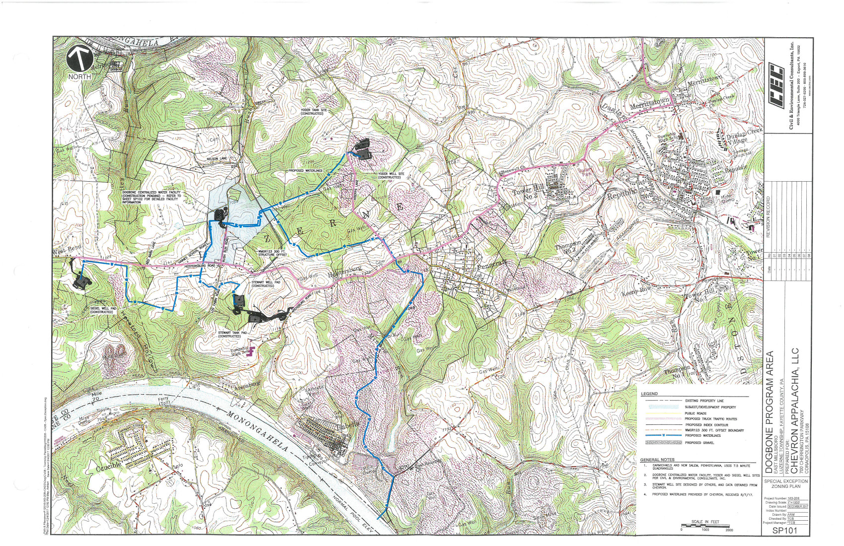
The Dogbone Centralized Water Facility was the subject of a Fayette County Zoning Hearing Board hearing on 12/13/2017, at which Chevron presented a topographic map including "proposed" pipelines. An unofficial copy of that map is available here:
<http://faymarwatch.org/documents/ZHB_17-41_121317_topo.pdf>
(and as the right-hand map in the "More Maps" section above). Although the pipelines show on this map as "proposed", the pipeline routings clearly include sections of existing pipelines, including the 4-H (Young) Pipeline and the buried section of the Dog Bone Waterline.
The hearing has been continued, with the continuance currently scheduled for 2/28/2018, 10 a.m., Fayette County Public Service Building, 22 East Main St., Uniontown PA.
There appears to be no visible difference (that can be discerned from the eFACTS web interface) between the current eFACTS entry for this facility vs. the previous time this authorization was listed in eNOTICE. There is presumably a difference in some database column or other that we are not seeing over the web.
---
The authorization record above for STEWART 7H shows Status as Pending; however the Open Data Repository record for this well shows the permit date as 2018-01-26, suggesting that the permit has in fact been issued and that the two databases are not automatically sync'ed.
---
There is something important to note about the inspection report above of the well Lee 11. As a mere comment, the inspector notes: "It is recommended the tanks be inspected to ensure integrity." This is a head-shaker. Why didn't that inspector just do that inspection at the time? The answer seems to be that DEP apparently has two totally separate crews doing inspections at well sites: one crew inspects the well pad Erosion & Sedimentation permits, and a separate crew inspects the actual wells and well equipment. Why can't these crews be cross-trained and do both kinds of inspections? If all an inspector can do when noting a problem that should be handled by the "other kind" of inspector is "recommend" in a comment, there is too much room for error in whether that "recommended" second inspection actually happens.
------------------------
DEP defines an environmental justice area as "any census tract where 20 percent or more individuals live in poverty, and/or 30 percent or more of the population is minority". (See:
<http://www.dep.pa.gov/PublicParticipation/OfficeofEnvironmentalJustice/Pages/default.aspx>). There are supposed to be enhanced public participation requirements for permits in environmental justice areas, but news of this actually ever happening is scarce. In Fayette County, the entirety of Springhill, Nicholson, German, and Georges Townships are environmental justice areas, as well as a large part of Dunbar Township. DEP's policy document on public participation guidelines for environmental justice areas is located here:
<http://www.elibrary.dep.state.pa.us/dsweb/Get/Version-48671/012-0501-002.pdf>
eNOTICE records are likely to list the same permit multiple times, as that permit moves through the DEP process.
Oil & Gas Wells designated with a site a number and the letter H typically designate horizontal wells.
-------------------------
Resources:
Pennsylvania Bulletin: <http://www.pabulletin.com/>
eNOTICE: <http://www.ahs2.dep.state.pa.
DEP Oil and Gas Reports: <http://www.dep.pa.gov/DataandTools/Reports/Oil%20and%20Gas%20Reports/Pages/default.aspx>
DEP Permits Issued Detail Report:
<http://www.depreportingservic
DEP SPUD (drilling started) Report:
<http://www.depreportingservices.state.pa.us/ReportServer/Pages/ReportViewer.aspx?/Oil_Gas/Spud_External_Data>
DEP Oil and Gas Compliance Report:
<http://www.depreportingservices.state.pa.us/ReportServer/Pages/ReportViewer.aspx?/Oil_Gas/OG_Compliance>
DEP PA Oil & Gas Mapping:
<http://www.depgis.state.pa.us/PaOilAndGasMapping>
Data Portal Services Directory [Technical]
<http://www.depgis.state.pa.us/arcgis/rest/services>
Query: Oil and Gas Wells All (ID: 3) [Technical]:
<http://www.depgis.state.pa.us/arcgis/rest/services/OilGas/OilGasAllStrayGas/MapServer/3/query?where=&text=&objectIds=&time=&geometry=&geometryType=esriGeometryEnvelope&inSR=&spatialRel=esriSpatialRelIntersects&relationParam=&outFields=OBJECTID%2CPERMIT_NUMBER%2CWELL_NAME%2COPERATOR%2COPERATOR_NUMBER%2CWELL_TYPE%2CWELL_TYPE_CODE%2CWELL_STATUS%2CWELL_STATUS_CODE%2CPERMIT_DATE%2CPERMIT_DATE_EXPIRES%2CSPUD_DATE%2CCONSERVATION_IND%2CCOUNTY%2CCOUNTY_ID%2CMUNICIPALITY%2CMUNICIPALITY_TYPE%2CMUNICIPALITY_CODE%2CLATITUDE%2CLONGITUDE%2CPRMRY_FID%2CUNCONVENTIONAL_IND%2CSURFACE_ELEVATION%2CWELL_CONFIG_CODE%2CCOAL_IND%2CWELL_PAD_NAME%2CSHAPE%2CDATE_PLUGGED%2CWELL_PAD_ID%2CUIC_ID%2CUIC_TYPE_DESCRIPTION%2CSTORAGE_FIELD_NAME%2CSITE_ID%2CSITE_NAME&returnGeometry=true&returnTrueCurves=false&maxAllowableOffset=&geometryPrecision=&outSR=&returnIdsOnly=false&returnCountOnly=false&orderByFields=&groupByFieldsForStatistics=&outStatistics=&returnZ=false&returnM=false&gdbVersion=&returnDistinctValues=false&resultOffset=&resultRecordCount=&f=html>
(Be sure to enter a Where clause in SQL format. Dates are in milliseconds since midnight 1/1/1970).
DEP Oil and Gas Electronic Notifications
<http://www.depreportingservices.state.pa.us/ReportServer?/Oil_Gas/OG_Notifications>
DEP Oil and Gas Well Pad Report
<http://www.depreportingservices.state.pa.us/ReportServer?/Oil_Gas/Well_Pads>
Fayette County Assessment Office Search For Tax Records:
<http://property.co.fayette.pa.us/search.aspx>
Pennsylvania Spatial Data Access:
<http://www.pasda.psu.edu/default.asp>
DEP Spatial Data Repository:
<ftp://www.pasda.psu.edu/pub/pasda/dep/>
National Response Center:
<http://www.nrc.uscg.mil/>
EPA-Echo: <http://www.epa-echo.gov/echo/
FERC citizen involvement: <http://www.ferc.gov/for-citiz
To receive E-mail notification of
all documents filed in a FERC docket, see:
<http://www.ferc.gov/docs-filing/esubscription.asp >
<http://www.ferc.gov/docs-fili
Follow the directions and enter the docket number to subscribe to.
Township Supervisors receive information regarding Erosion & Sedimentation permits, and these records may be reviewable at township municipal offices.
DEP permits are reviewable through the File Review process, for application to do file review see: <http://www.portal.state.pa.us/portal/server.pt/community/southwest_regional_office/13775/file_review/593164>
Environmental Hearing Board: <http://ehb.courtapps.com/publ
PA DEP Environmental Policy Comment System:
<http://www.ahs.dep.pa.gov/eComment/>
Federal Register Environment: <https://www.federalregister.g
Browsing of recent comment
opportunities for federal agencies, e.g. EPA. Click "sign up" to
subscribe to daily E-mails of new document listings.
SkyTruth Fayette County Drilling Alerts: <http://frack.skytruth.org/pen
U.S. Army Corps of Engineers, Pittsburgh District, Public Notices:
<http://www.lrp.usace.army.mil/Missions/Regulatory/Public-Notices/>
EPA Pennsylvania Public Notices: <http://www2.epa.gov/aboutepa/epa-pennsylvania#notice>
Marcellus Shale waste disposal
injection wells in Pennsylvania are regulated directly by EPA, not
DEP. Notice of any new permit applications will appear at the
above web address. I'm not aware of any subscription service
to be notified of such applications. I'm not aware of any
Marcellus Shale waste disposal injection wells in Fayette County
(yet ...) but we need to monitor this page for future
applications.
Energy Assurance Daily: <http://www.oe.netl.doe.gov/ead.aspx>
Daily newsletter from the US
Department of Energy about events relating to energy. The Natural
Gas section has information about pipelines.
-------------------------
Disclaimers:
This compilation from the above sources was done by hand using copy and paste and may omit relevant permits.
Parcel data is provided via the tax records search web page offered by the Fayette County Assessment Office (http://property.co.fayette.pa.us/). Presumed Parcel Id links are subject to availability provided by that agency and associated web sites. Presumed Parcel Ids are determined as the mapped parcel containing a given latitude and longitude, are a best effort determination which is subject to error, and are not official. In cases where a facility is leased and there is a separate parcel id for the lease, if this parcel id is not separately mapped, the parcel id shown will be the id for the enclosing parcel. Parcel owners may be surface owners only and may or may not have any relationship to oil & gas facilities.
Does not currently include water supply permits. Does not include landfill permits even though many such are for Marcellus Shale waste. (It is not possible at this time to distinguish which landfill permits are for Marcellus Shale waste and which are not without doing File Review for each permit.)
Erosion & Sedimentation permit records do not currently include latitude and longitude. Where I am publishing latitude and longitude with E&S permits it is by inferring an associated well permit and using published latitude and longitude for the well. It is possible I may be inferring the wrong well site.
Municipalities are shown from eFACTS records on the DEP web site. The DEP has been known to list a municipality incorrectly.