The Harmed Success Stories Concepts How To What Is Commentary
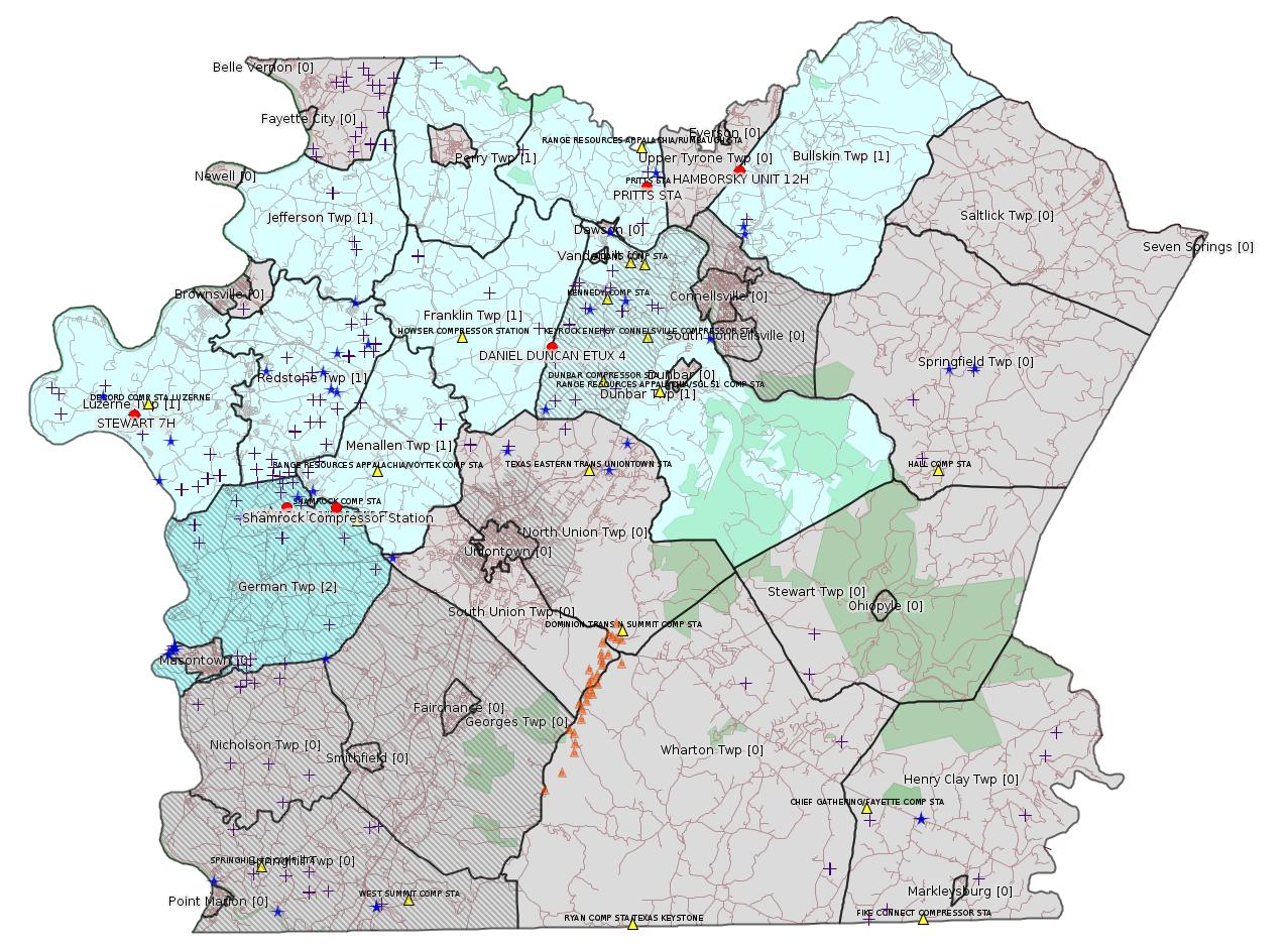
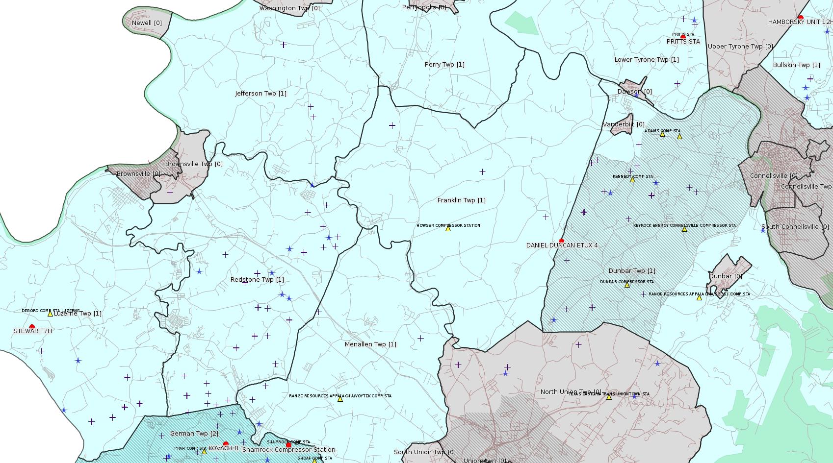
Fayette County Marcellus Shale Permits 1/29/18 - 2/11/18
Click the map to enlarge
Map
Key
Red dots: items in this permit list with an exact location.
Blue stars: Marcellus Gas Well Water Sources.
Municipality shading: number of "facilities", with each well counting separately
(includes the red dots):
Red dots: items in this permit list with an exact location.
Blue stars: Marcellus Gas Well Water Sources.
Municipality shading: number of "facilities", with each well counting separately
(includes the red dots):
gray: 0
pale turquoise: 1
turquoise: 2
pale blue: 3
middle blue: 4
dark blue: 5
dark purple: 6
purple: 14
(Color coding may differ from one issue to the next.)
(Note if a project spans multiple municipalities -- e.g. a pipeline -- it will show in the count for each municipality.)
The number of facilities also follows the municipality name in brackets.
Municipality counts are based on the way the permit is listed by DEP; DEP has been known to get a municipality wrong.
Locations in brackets identify a precise location used to locate a surrogate for the actual site being permitted (e.g. locating a well pad or pipeline by the known location of a well.) Locations labeled beginning with "~" and ending in "[?]" are approximate and speculative based on inferences using on-line property and lease records. These are marked in the text as "[Approximate, Speculative]
Cross-hatching: Environmental Justice Areas
Yellow triangles: Compressor Stations
Orange triangles: Storage Field Wells (currently Dominion North Summit Storage Field)
Crosses: SPUD Unconventional well permits
Green: "Natural areas", e.g. state game lands, state forests
Yellow triangles: Compressor Stations
Orange triangles: Storage Field Wells (currently Dominion North Summit Storage Field)
Crosses: SPUD Unconventional well permits
Green: "Natural areas", e.g. state game lands, state forests
More Maps
 |
Source: Pennsylvania Bulletin
NOTICES
PENNSYLVANIA PUBLIC
UTILITY COMMISSION
Act 13 of 2012; Producer Fees for Calendar Year 2017
[48 Pa.B. 839]
[Saturday, February 3, 2018]
Average Annual Price of Natural Gas for
Calendar Year 2017:(1)
$3.11
Consumer Price Index (CPI), Urban Consumers,
PA, NJ, DE and MD:(2)
0.8%
Number of Spud Wells for Calendar
Years 2016 and 2017
2016 2017
Number of wells spud 503 786
CPI adjustment to spud well fees is applicable in 2017. See 58 Pa.C.S. § 2302(c) (relating to unconventional gas well fee).
Unconventional Gas Well Fees for Calendar
Year 2017
Year of Well(3) Horizontal Vertical—Producing
Year 1 $50,700 $10,100
Year 2 $40,500 $8,100
Year 3 $30,400 $6,100
Year 4—10 $20,300 $4,100
(1) Source: www.business.directenergy.com
(2) Source: www.bls.gov
(3) Horizontal unconventional gas wells pay the yearly fee upon spudding plus 2 subsequent years. Fees after the first 3 years are based on production levels as defined in 58 Pa.C.S. § 2302(b.1). Vertical wells producing gas levels above a 90,000 cubic foot average in any given month during the current year are subject to 20% of the applicable horizontal well fee.
ROSEMARY CHIAVETTA,
Secretary
<https://www.pabulletin.com/secure/data/vol48/48-5/199.html>
-------------------------
Source: eNOTICE (+ PA Oil and Gas Mapping, Well Pad Report.) Well Details via Data Portal Services: Oil and Gas Wells All (ID: 3).
Please see the Disclaimer below regarding Parcel Id data.
Authorization ID: 1136973
Permit number: GP5-26-00578C
Site: PRITTS STA
Client: LAUREL MTN MIDSTREAM OPR LLC
Authorization type: AQ General Permit
Application type: New
Authorization is for: FACILITY
Date received: 05/10/2016
Status: Pending
Permit Decision Guarantee Applies?: No
Sub-Facilities for Authorization:
Sub-Facility ID Sub-Facility Name Description
1070885 DEHYDRATION UNIT(S) Process
1044372 EMIT TECHNOLOGIES OXIDATION CATALYST Air Pollution Control Device
1044365 ENG #2 CATERPILLAR G3516B 1380 BHP COMPRESSOR Process
1070888 FUGITIVES Process
1183055 HEATERS/REBOILERS Process
1196012 PIGGING OPERATIONS Process
1183053 PNEUMATIC DEVICES Process
1183054 TANKS/VESSELS Process
1183052 VENTING/BLOWDOWNS Process
Permit Review Notes:
Date Review Note
5/11/2016 The permit application package is complete, has been accepted, and is undergoing technical review.
<http://www.ahs.dep.pa.gov/eFACTSWeb/searchResults_singleAuth.aspx?AuthID=1136973>
Site Programs:
Air Quality
Municipalities:
Lower Tyrone Twp, Fayette County
Location: 40.066216,-79.633629 <http://osm.org/go/ZWp370n6--?m=>
Municipalities: Lower Tyrone Twp
Parcel Id: 1808001301
Fayette County Act 14 Notification: <http://faymarwatch.org/documents/Pritts_NOI_GP5-26-00578C.pdf>
[See Notes.]
Authorization ID: 1203103
Permit number: 051-24639
Site: STEWART WELL SITE ESCGP-2 EXPEDITED
Client: CHEVRON APPALACHIA LLC
Authorization type: Drill & Operate Well Permit (Unconventional)
Application type: New
Authorization is for: FACILITY
Date received: 10/17/2017
Status: Issued on 1/26/2018
Permit Decision Guarantee Applies?: No
Sub-Facilities for Authorization:
Sub-Facility ID Sub-Facility Name Description
1246056 WELLBORE SURFACE HOLE LOCATION Well
Permit Review Notes:
Date Review Note
1/4/2018 Applicant has been issued a deficiency letter. If applicable, this application no longer qualifies for the Permit Decision Guarantee.
1/4/2018 The technical review and decision review are complete and either the permit decision and/or permit issuance are forthcoming.
11/15/2017 The permit application package is complete, has been accepted, and is undergoing technical review.
<http://www.ahs.dep.pa.gov/eFACTSWeb/searchResults_singleAuth.aspx?AuthID=1203103>
Site Programs:
Oil & Gas
Municipalities:
Luzerne Twp, Fayette County
Well Details:
Permit Number: 051-24639
Well Name: STEWART 7H
Unconventional Well: Y
Well Configuration: Horizontal Well
Well Type: GAS
Well Status: Active
Coal Association: Coal
Conservation Well: N
Primary Facility ID: 822072
Site ID: 788124
Site Name: STEWART WELL SITE ESCGP-2 EXPEDITED
Well Pad ID: 152396
Well Pad Name: STEWART
Storage Field:
Operator: CHEVRON APPALACHIA LLC
Operator Number: OGO-39307
Permit Date: 2018-01-26
Permit Date Expires: 2019-01-26
SPUD Date:
Date Plugged:
UIC ID:
UIC Type:
Surface Elevation: 1140
County: Fayette
Municipality: Luzerne Twp
Location: 39.962917,-79.946617
Map URL: <http://www.openstreetmap.org/?mlat=39.962917&mlon=-79.946617#map=15/39.962917/-79.946617>
Presumed Parcel Id: 19250010
Documents [excepting Affidavits of Non-Delivery]:
DOCUMENT_NAME: Stewart Pad A PNDI 8-22-17.pdfLanding Point: 39.960906,-79.9456023
DOCUMENT_TYPE: Pennsylvania Natural Diversity Inventory Form
<http://www.depgis.state.pa.us/eWellDocHandler/pdFHandler.ashx?Doc=MzcwNTYy>
DOCUMENT_NAME: Stewart Well Plats 7H.dwg
DOCUMENT_TYPE: Location Plat
<http://www.depgis.state.pa.us/eWellDocHandler/pdFHandler.ashx?Doc=MzkxMTE3>
DOCUMENT_NAME: Stewart 1H-7H Waiver Request Section 7.pdf
DOCUMENT_TYPE: Coal and Gas Resource Coord Act - Section 7 Exception
<http://www.depgis.state.pa.us/eWellDocHandler/pdFHandler.ashx?Doc=MzkxMTE4>
DOCUMENT_NAME: Stewart 7H Page 4.pdf
DOCUMENT_TYPE: Well Cross-Section Diagram
<http://www.depgis.state.pa.us/eWellDocHandler/pdFHandler.ashx?Doc=MzkxMTE5>
DOCUMENT_NAME: Stewart 1H-7H 2017 Coal Module.pdf
DOCUMENT_TYPE: Well Permit Application - Coal Module
<http://www.depgis.state.pa.us/eWellDocHandler/pdFHandler.ashx?Doc=MzkxMTIw>
DOCUMENT_NAME: 1609175.pdf
DOCUMENT_TYPE: Permit Application to Drill and Operate a Well
<http://www.depgis.state.pa.us/eWellDocHandler/pdFHandler.ashx?Doc=MzkyODA2>
Inflection Point: 39.9510634,-79.933606
Bottom Hole: 39.935717,-79.918111
Wellbore Deepest Point True Vertical Depth (TVD): 8045
Wellbore Deepest Point Total Measured Distance (TMD): 8462
Bottom Hole True Vertical Depth (TVD): 8045
Bottom Hole Total Measured Distance (TMD): 20459
[See Notes.]
Authorization ID: 1206946
Permit number: ESX11-051-0016
Site: CONSTANTINE TO LYNN PIPELINE ESXGP-EXPEDITED
Client: LAUREL MTN MIDSTREAM OPR LLC
Authorization type: Expedited E&S Stormwater General Permit 1
Application type: Notification
Authorization is for: SITE
Date received: 11/15/2017
Status: Issued on 1/30/2018
Permit Decision Guarantee Applies?: No
Permit Review Notes:
Date Review Note
1/30/2018 The technical review and decision review are complete and either the permit decision and/or permit issuance are forthcoming.
11/15/2017 The permit application package is complete, has been accepted, and is undergoing technical review.
<http://www.ahs.dep.pa.gov/eFACTSWeb/searchResults_singleAuth.aspx?AuthID=1206946>
Site Programs:
Municipalities:
Franklin Twp, Fayette County
Jefferson Twp, Fayette County
Menallen Twp, Fayette County
Perry Twp, Fayette County
Redstone Twp, Fayette County
Rostraver Twp, Westmoreland County
Authorization ID: 1210459
Permit number: 051-24640
Site: KOVACH B
Client: CHEVRON APPALACHIA LLC
Authorization type: Drill & Operate Well Permit (Unconventional)
Application type: New
Authorization is for: FACILITY
Date received: 12/15/2017
Status: Pending
Permit Decision Guarantee Applies?: No
Sub-Facilities for Authorization:
Sub-Facility ID Sub-Facility Name Description
1250546 WELLBORE SURFACE HOLE LOCATION Well
Permit Review Notes:
Date Review Note
2/8/2018 Applicant has been issued a deficiency letter. If applicable, this application no longer qualifies for the Permit Decision Guarantee.
1/8/2018 The permit application package is complete, has been accepted, and is undergoing technical review.
<http://www.ahs.dep.pa.gov/eFACTSWeb/searchResults_singleAuth.aspx?AuthID=1210459>
Site Programs:
Oil & Gas
Municipalities:
German Twp [an Environmental Justice Area], Fayette County
Well Details:
Permit Number: 051-24640
Well Name: KOVACH B 1
Unconventional Well: Y
Well Configuration: Vertical Well
Well Type: GAS
Well Status: Active
Coal Association: Coal
Conservation Well: N
Primary Facility ID: 823474
Site ID: 826935
Site Name: KOVACH B
Well Pad ID: 155005
Well Pad Name: KOVACH B
Storage Field:
Operator: CHEVRON APPALACHIA LLC
Operator Number: OGO-39307
Permit Date:
Permit Date Expires:
SPUD Date:
Date Plugged:
UIC ID:
UIC Type:
Surface Elevation: 1278
County: Fayette
Municipality: German Twp
Location: 39.918967,-79.854906
Map URL: <http://www.openstreetmap.org/?mlat=39.918967&mlon=-79.854906#map=15/39.918967/-79.854906>
Documents [excepting Affidavits of Non-Delivery]:
DOCUMENT_NAME: Kovach B PNDI.pdfParcel Id: 1511002301
DOCUMENT_TYPE: Pennsylvania Natural Diversity Inventory Form
<http://www.depgis.state.pa.us/eWellDocHandler/pdFHandler.ashx?Doc=NDM0MTAy>
DOCUMENT_NAME: Kovach B Section 7 Exception.pdf
DOCUMENT_TYPE: Coal and Gas Resource Coord Act - Section 7 Exception
<http://www.depgis.state.pa.us/eWellDocHandler/pdFHandler.ashx?Doc=NDM0MTAz>
DOCUMENT_NAME: Kovach B 1 Plat 1-3-18.dwg
DOCUMENT_TYPE: Location Plat
<http://www.depgis.state.pa.us/eWellDocHandler/pdFHandler.ashx?Doc=NDQ4NTc0>
DOCUMENT_NAME: 1654493.pdf
DOCUMENT_TYPE: Permit Application to Drill and Operate a Well
<http://www.depgis.state.pa.us/eWellDocHandler/pdFHandler.ashx?Doc=NDQ4NzMz>
Wellbore Origin Point True Vertical Depth (TVD): 8400
[See Notes.]
Authorization ID: 1216447
Permit number: 26-00588
Site: SHAMROCK COMP STA
Client: LAUREL MTN MIDSTREAM OPR LLC
Authorization type: Minor Facility Plan Approval New Source Performance Std
Application type: Extension
Authorization is for: FACILITY
Date received: 01/26/2018
Status: Pending
Permit Decision Guarantee Applies?: No
<http://www.ahs.dep.pa.gov/eFACTSWeb/searchResults_singleAuth.aspx?AuthID=1216447>
Site Programs:
Air Quality
Municipalities:
German Twp [an Environmental Justice Area], Fayette County
Location: 39.918333,-79.825 <http://osm.org/go/ZWpasXGm--?m=>
Parcel ID: 15140026
Authorization ID: 1216448
Permit number: 26-00588A
Site: SHAMROCK COMP STA
Client: LAUREL MTN MIDSTREAM OPR LLC
Authorization type: Major Facility Plan Approval New Facility Review Prevention of Significant Deterioration
Application type: Extension
Authorization is for: FACILITY
Date received: 01/26/2018
Status: Pending
Permit Decision Guarantee Applies?: No
<http://www.ahs.dep.pa.gov/eFACTSWeb/searchResults_singleAuth.aspx?AuthID=1216448>
Site Programs:
Air Quality
Municipalities:
German Twp [an Environmental Justice Area], Fayette County
-------------------------
Source: DEP Oil and Gas Electronic Notifications
[Conventional Well:]
NOTIFICATION_ID: 39202
OGO: 65675
OPERATOR: ALLIANCE PETROLEUM CORP
API_PERMIT: 051-21017
SPUD_DATE: 09/17/1998
COUNTY: Fayette
MUNICIPALITY: Dunbar
LATITUDE: 39.991844
LONGITUDE: -79.6932
SUBJECT: [NOTIFICATION]: Notification of return of regulatory inactive well to active status 3214(d) for well API 37-051-21017-00-00
QUESTION: Select from wells that are Regulatory Inactive and have been SPUD
ANSWER: 051-21017
SENT_DATE: 2/8/2018 9:05:01 AM
SENT_SUCCESS: Yes
LAST_RESENT_DATE:
RESENT_SUCCESS:
Comments:
Well Details:
Permit Number: 051-21017Map URL: <http://www.openstreetmap.org/?mlat=39.991844&mlon=-79.6932#map=15/39.991844/-79.6932>
Well Name: DANIEL DUNCAN ETUX 4
Unconventional Well: N
Well Configuration: Vertical Well
Well Type: GAS
Well Status: Active
Coal Association: NonCoal
Conservation Well: N
Primary Facility ID: 518869
Site ID: 490525
Site Name: DANIEL DUNCAN ET UX 4 OG WELL
Well Pad ID: 0
Well Pad Name:
Storage Field:
Operator: ALLIANCE PETROLEUM CORP
Operator Number: OGO-65675
Permit Date: 1998-08-03
Permit Date Expires: 1999-08-03
SPUD Date: 1998-09-17
Date Plugged:
UIC ID:
UIC Type:
Surface Elevation: 1195
County: Fayette
Municipality: Dunbar Twp
Location: 39.991844,-79.6932 [an Environmental Justice Area]
Presumed Parcel Id: 09200077
-------------------------
Source: DEP Oil and Gas Compliance Report
OPERATOR: CHEVRON APPALACHIA LLC
INSPECTION_ID: 2685605
INSPECTION_DATE: 01/22/2018
INSPECTION_TYPE: Routine/Partial Inspection
API_PERMIT: 051-24381
FARM_NAME: HAMBORSKY UNIT 12H
UNCONVENTIONAL: Yes
SITE_ID: 737696
SITE_NAME: HAMBORSKY UNIT 12H OG WELL
FACILITY_TYPE: Oil & Gas Location
INSPECTION_CATEGORY: Primary Facility
REGION: EP DOGO SWDO Dstr Off
COUNTY: Fayette
MUNICIPALITY: Bullskin Twp
INSPECTOR: WITHAM, CYNTHIA
INSPECTION_SOURCE: SAIR
INSPECTION_RESULT_DESCRIPTION: Violation(s) Noted
INSPECTION_COMMENT: "Routine partial inspection due to well site being surrounded by security fence. Well appears equipped for production. Two brine tanks on site. The NOT for this site was approved in 2013.
Department observed erosion gully beginning to form and a small amount of what appears to be water leaving well pad area on NW side of well pad. Department contacted operator rep Chad Eiserman by phone from site. Mr. Eiserman stated that Chevron personnel will be sent to site and he would follow up with department.
UPDATE 14:57: Operator rep Curtis Small contacted Department by phone. Mr. Small stated a Chevron rep will be on site today and inspect the NW area of the well pad. Mr. Small also stated that he personally would be on site first thing tomorrow morning and will follow up with Department by phone or email. Department requested operator determine the source of the water leaving the site. Mr. Small stated that information would be provided in the follow up call/email.
UPDATE 1-23-18: Operator rep Curtis Small contacted Department by phone. Mr. Small stated he was on site today. He believes the water leaving the pad is surface run off; he recorded a water sample reading of 290 microsemens this morning.
He also stated the well tender said that after heavy rains water often drains from the pad in that area.
Violation is being issued for failure to comply with 25 PA Code 102 (E and S requirements).
A follow up inspection will be conducted at a later date."
VIOLATION_ID: 807089
VIOLATION_DATE: 01/22/2018
VIOLATION_CODE: 78a53 - EROSION AND SEDIMENT CONTROL AND STORMWATER MANAGEMENT - Person proposing or conducting earth disturbance activities associated with oil and gas operations failed to comply with 25 Pa. Code § 102.
VIOLATION_TYPE: Environmental Health & Safety
VIOLATION_COMMENT: Liquid leaving well pad area.
RESOLVED_DATE:
RESOLUTION_REASON_CODE_DESCRIPTION:
CONTINUING_VIOLATION:
ENFORCEMENT_ID: 361157
ENFORCEMENT_CODE_DESCRIPTION: NOV - Notice of Violation
DATE_EXECUTED: 01/22/2018
ENFORCEMENT_FINAL_DATE:
ENFORCEMENT_FINAL_STATUS:
PENALTY_FINAL_DATE:
PENALTY_FINAL_STATUS_CODE_DESCRIPTION:
PENALTY_AMOUNT:
TOTAL_AMOUNT_COLLECTED:
OPERATOR: CHEVRON APPALACHIA LLC
INSPECTION_ID: 2691626
INSPECTION_DATE: 02/06/2018
INSPECTION_TYPE: Administrative/File Review
API_PERMIT: 051-24381
FARM_NAME: HAMBORSKY UNIT 12H
UNCONVENTIONAL: Yes
SITE_ID: 737696
SITE_NAME: HAMBORSKY UNIT 12H OG WELL
FACILITY_TYPE: Oil & Gas Location
INSPECTION_CATEGORY: Primary Facility
REGION: EP DOGO SWDO Dstr Off
COUNTY: Fayette
MUNICIPALITY: Bullskin Twp
INSPECTOR: WITHAM, CYNTHIA
INSPECTION_SOURCE: SAIR
INSPECTION_RESULT_DESCRIPTION: Outstanding Violations - Viols Req'd
INSPECTION_COMMENT: "ADMIN inspection to inspection record #2685605 where a violation was issued for operator failure to comply with E and S requirements.
Department received operator response to NOV via email.
Previously issued violation still exists for this well site.
A follow up inspection will be conducted at a later date."
VIOLATION_ID: 807632
VIOLATION_DATE: 01/06/2018
VIOLATION_CODE: 78a53 - EROSION AND SEDIMENT CONTROL AND STORMWATER MANAGEMENT - Person proposing or conducting earth disturbance activities associated with oil and gas operations failed to comply with 25 Pa. Code § 102.
VIOLATION_TYPE: Environmental Health & Safety
VIOLATION_COMMENT: What appears to water is leaving well pad area, entering Ag field.
RESOLVED_DATE:
RESOLUTION_REASON_CODE_DESCRIPTION:
CONTINUING_VIOLATION: Yes
ENFORCEMENT_ID:
ENFORCEMENT_CODE_DESCRIPTION:
DATE_EXECUTED:
ENFORCEMENT_FINAL_DATE:
ENFORCEMENT_FINAL_STATUS:
PENALTY_FINAL_DATE:
PENALTY_FINAL_STATUS_CODE_DESCRIPTION:
PENALTY_AMOUNT:
TOTAL_AMOUNT_COLLECTED:
Well Details:
Permit Number: 051-24381Map URL: <http://www.openstreetmap.org/?mlat=40.072761&mlon=-79.577281#map=15/40.072761/-79.577281>
Well Name: HAMBORSKY UNIT 12H
Unconventional Well: Y
Well Configuration: Horizontal Well
Well Type: GAS
Well Status: Active
Coal Association: Coal
Conservation Well: Y
Primary Facility ID: 733126
Site ID: 737696
Site Name: HAMBORSKY UNIT 12H OG WELL
Well Pad ID: 148470
Well Pad Name: HAMBORSKY UNIT 12H
Storage Field:
Operator: CHEVRON APPALACHIA LLC
Operator Number: OGO-39307
Permit Date: 2010-09-09
Permit Date Expires: 2011-09-09
SPUD Date: 2011-06-13
Date Plugged:
UIC ID:
UIC Type:
Surface Elevation: 1200
County: Fayette
Municipality: Bullskin Twp
Location: 40.072761,-79.577281
Presumed Parcel Id: 04280001
[See Notes.]
-------------------------
Source: Reuters Commodities: Energy
Natural Gas
| Commodity | Exchange | Currency | Expire | Last Trade | Trade Time | Change | Open | Day's High | Day's Low |
|---|---|---|---|---|---|---|---|---|---|
| NATURAL
GAS CON1 Feb18 |
NYM | USD | 02/26 | 2.58 | 02/12 18:42 | +0.02 | 2.57 | 2.58 | 2.56 |
<http://www.reuters.com/finance/commodities/energy>
-------------------------
Notes:
[Repeat note from the 5/15/16 issue of this bulletin]: The most recent prior permit for the Pritts Compressor Station was issued in 2011, as listed in PA Bulletin [41 Pa.B. 3739], [Saturday, July 9, 2011]:
GP5-26-00578B: Laurel Mountain Midstream, LLC (1550 Coraopolis Height Road, 2nd Floor, Moon Township, PA 15108) on June 17, 2011, to allow modification and operation of a natural gas production facility with the addition of five lean burn natural gas-fired compressor engines rated at 1,380 bhp each controlled by oxidation catalysts, and two 30 MMscfd dehydration units with reboilers rated at 0.5 MMBtu/hr and controlled by a flare. The facility will be authorized under GP-5 for natural gas production at the Pritts Compressor Station located in Lower Tyrone Township, Fayette County.
<http://www.pabulletin.com/secure/data/vol41/41-28/1137c.html>
That makes altogether 6 compression engines as of 2011. The current application is apparently in lieu of a straight renewal; LMM is reducing the facility to one compression engine, one dehydrator, and a flare (and other miscellaneous equipment). For details see the NOI listed above.
---
DEP is now requiring electronic document submission for operators of unconventional gas wells. The plats -- which used to be available as .pdf files -- are now required to be submitted as .dwg files. .dwg is a CAD software file format family; to be able to view .dwg files you will need to install a .dwg viewer or a full CAD package. An unofficial .pdf version of pages 1-3 of the plat for Stewart 7H is available here:
<http://faymarwatch.org/documents/stewart_well_pad/jr_Stewart%20Well%20Plats%207H_pp_1-3.pdf>
Note that there has been some color conversion (currently incomplete) in converting to .pdf to make the plat more readable. (Stay tuned for a more complete approach to the .dwg file problem in the future.)
---
An unofficial .pdf version of the plat for Kovach B 1 is available here:
<http://faymarwatch.org/documents/kovach_b_well_pad/jr_Kovach%20B%201%20Plat%201-3-18.pdf>
Note that there has been some color conversion (currently incomplete) in converting to .pdf to make the plat more readable.
---
The comment in inspection report 2685605 above is pasted directly from the text on the DEP's web site. There is a unit of conductivity (which would make sense for measuring runoff) called "microsiemens", which is evidently what was intended.
------------------------
DEP defines an environmental justice area as "any census tract where 20 percent or more individuals live in poverty, and/or 30 percent or more of the population is minority". (See:
<http://www.dep.pa.gov/PublicParticipation/OfficeofEnvironmentalJustice/Pages/default.aspx>). There are supposed to be enhanced public participation requirements for permits in environmental justice areas, but news of this actually ever happening is scarce. In Fayette County, the entirety of Springhill, Nicholson, German, and Georges Townships are environmental justice areas, as well as a large part of Dunbar Township. DEP's policy document on public participation guidelines for environmental justice areas is located here:
<http://www.elibrary.dep.state.pa.us/dsweb/Get/Version-48671/012-0501-002.pdf>
eNOTICE records are likely to list the same permit multiple times, as that permit moves through the DEP process.
Oil & Gas Wells designated with a site a number and the letter H typically designate horizontal wells.
-------------------------
Resources:
Pennsylvania Bulletin: <http://www.pabulletin.com/>
eNOTICE: <http://www.ahs2.dep.state.pa.
DEP Oil and Gas Reports: <http://www.dep.pa.gov/DataandTools/Reports/Oil%20and%20Gas%20Reports/Pages/default.aspx>
DEP Permits Issued Detail Report:
<http://www.depreportingservic
DEP SPUD (drilling started) Report:
<http://www.depreportingservices.state.pa.us/ReportServer/Pages/ReportViewer.aspx?/Oil_Gas/Spud_External_Data>
DEP Oil and Gas Compliance Report:
<http://www.depreportingservices.state.pa.us/ReportServer/Pages/ReportViewer.aspx?/Oil_Gas/OG_Compliance>
DEP PA Oil & Gas Mapping:
<http://www.depgis.state.pa.us/PaOilAndGasMapping>
Data Portal Services Directory [Technical]
<http://www.depgis.state.pa.us/arcgis/rest/services>
Query: Oil and Gas Wells All (ID: 3) [Technical]:
<http://www.depgis.state.pa.us/arcgis/rest/services/OilGas/OilGasAllStrayGas/MapServer/3/query?where=&text=&objectIds=&time=&geometry=&geometryType=esriGeometryEnvelope&inSR=&spatialRel=esriSpatialRelIntersects&relationParam=&outFields=OBJECTID%2CPERMIT_NUMBER%2CWELL_NAME%2COPERATOR%2COPERATOR_NUMBER%2CWELL_TYPE%2CWELL_TYPE_CODE%2CWELL_STATUS%2CWELL_STATUS_CODE%2CPERMIT_DATE%2CPERMIT_DATE_EXPIRES%2CSPUD_DATE%2CCONSERVATION_IND%2CCOUNTY%2CCOUNTY_ID%2CMUNICIPALITY%2CMUNICIPALITY_TYPE%2CMUNICIPALITY_CODE%2CLATITUDE%2CLONGITUDE%2CPRMRY_FID%2CUNCONVENTIONAL_IND%2CSURFACE_ELEVATION%2CWELL_CONFIG_CODE%2CCOAL_IND%2CWELL_PAD_NAME%2CSHAPE%2CDATE_PLUGGED%2CWELL_PAD_ID%2CUIC_ID%2CUIC_TYPE_DESCRIPTION%2CSTORAGE_FIELD_NAME%2CSITE_ID%2CSITE_NAME&returnGeometry=true&returnTrueCurves=false&maxAllowableOffset=&geometryPrecision=&outSR=&returnIdsOnly=false&returnCountOnly=false&orderByFields=&groupByFieldsForStatistics=&outStatistics=&returnZ=false&returnM=false&gdbVersion=&returnDistinctValues=false&resultOffset=&resultRecordCount=&f=html>
(Be sure to enter a Where clause in SQL format. Dates are in milliseconds since midnight 1/1/1970).
DEP Oil and Gas Electronic Notifications
<http://www.depreportingservices.state.pa.us/ReportServer?/Oil_Gas/OG_Notifications>
DEP Oil and Gas Well Pad Report
<http://www.depreportingservices.state.pa.us/ReportServer?/Oil_Gas/Well_Pads>
Fayette County Assessment Office Search For Tax Records:
<http://property.co.fayette.pa.us/search.aspx>
Pennsylvania Spatial Data Access:
<http://www.pasda.psu.edu/default.asp>
DEP Spatial Data Repository:
<ftp://www.pasda.psu.edu/pub/pasda/dep/>
National Response Center:
<http://www.nrc.uscg.mil/>
EPA-Echo: <http://www.epa-echo.gov/echo/
FERC citizen involvement: <http://www.ferc.gov/for-citiz
To receive E-mail notification of
all documents filed in a FERC docket, see:
<http://www.ferc.gov/docs-filing/esubscription.asp >
<http://www.ferc.gov/docs-fili
Follow the directions and enter the docket number to subscribe to.
Township Supervisors receive information regarding Erosion & Sedimentation permits, and these records may be reviewable at township municipal offices.
DEP permits are reviewable through the File Review process, for application to do file review see: <http://www.portal.state.pa.us/portal/server.pt/community/southwest_regional_office/13775/file_review/593164>
Environmental Hearing Board: <http://ehb.courtapps.com/publ
PA DEP Environmental Policy Comment System:
<http://www.ahs.dep.pa.gov/eComment/>
Federal Register Environment: <https://www.federalregister.g
Browsing of recent comment
opportunities for federal agencies, e.g. EPA. Click "sign up" to
subscribe to daily E-mails of new document listings.
SkyTruth Fayette County Drilling Alerts: <http://frack.skytruth.org/pen
U.S. Army Corps of Engineers, Pittsburgh District, Public Notices:
<http://www.lrp.usace.army.mil/Missions/Regulatory/Public-Notices/>
EPA Pennsylvania Public Notices: <http://www2.epa.gov/aboutepa/epa-pennsylvania#notice>
Marcellus Shale waste disposal
injection wells in Pennsylvania are regulated directly by EPA, not
DEP. Notice of any new permit applications will appear at the
above web address. I'm not aware of any subscription service
to be notified of such applications. I'm not aware of any
Marcellus Shale waste disposal injection wells in Fayette County
(yet ...) but we need to monitor this page for future
applications.
Energy Assurance Daily: <http://www.oe.netl.doe.gov/ead.aspx>
Daily newsletter from the US
Department of Energy about events relating to energy. The Natural
Gas section has information about pipelines.
-------------------------
Disclaimers:
This compilation from the above sources was done by hand using copy and paste and may omit relevant permits.
Parcel data is provided via the tax records search web page offered by the Fayette County Assessment Office (http://property.co.fayette.pa.us/). Presumed Parcel Id links are subject to availability provided by that agency and associated web sites. Presumed Parcel Ids are determined as the mapped parcel containing a given latitude and longitude, are a best effort determination which is subject to error, and are not official. In cases where a facility is leased and there is a separate parcel id for the lease, if this parcel id is not separately mapped, the parcel id shown will be the id for the enclosing parcel. Parcel owners may be surface owners only and may or may not have any relationship to oil & gas facilities.
Does not currently include water supply permits. Does not include landfill permits even though many such are for Marcellus Shale waste. (It is not possible at this time to distinguish which landfill permits are for Marcellus Shale waste and which are not without doing File Review for each permit.)
Erosion & Sedimentation permit records do not currently include latitude and longitude. Where I am publishing latitude and longitude with E&S permits it is by inferring an associated well permit and using published latitude and longitude for the well. It is possible I may be inferring the wrong well site.
Municipalities are shown from eFACTS records on the DEP web site. The DEP has been known to list a municipality incorrectly.