The Harmed Success Stories Concepts How To What Is Commentary
Fayette County Marcellus Shale Permits 3/20/17 - 4/2/17
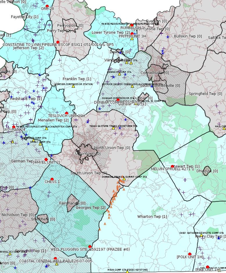
Click the map to enlarge
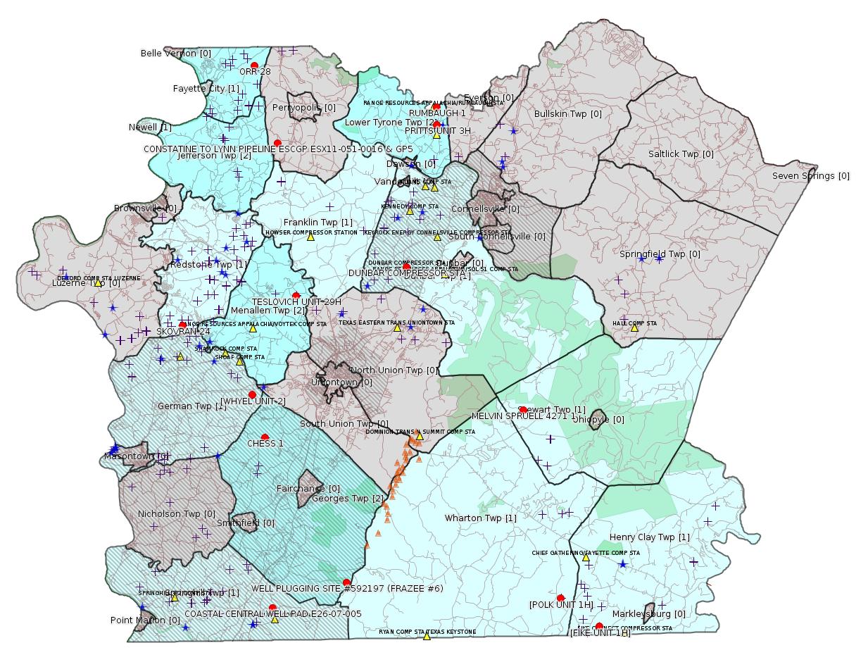
Map
Key
Red dots: items in this permit list with an exact location.
Blue stars: Marcellus Gas Well Water Sources.
Municipality shading: number of "facilities", with each well counting separately
(includes the red dots):
Red dots: items in this permit list with an exact location.
Blue stars: Marcellus Gas Well Water Sources.
Municipality shading: number of "facilities", with each well counting separately
(includes the red dots):
gray: 0
pale turquoise: 1
turquoise: 2
pale blue: 3
middle blue: 4
dark blue: 6
dark purple: 10
purple: 19
(Color coding may differ from one issue to the next.)
(Note if a project spans multiple municipalities -- e.g. a pipeline -- it will show in the count for each municipality.)
The number of facilities also follows the municipality name in brackets.
Municipality counts are based on the way the permit is listed by DEP; DEP has been known to get a municipality wrong.
Locations in brackets identify a precise location used to locate a surrogate for the actual site being permitted (e.g. locating a well pad or pipeline by the known location of a well.) Locations labeled beginning with "~" and ending in "[?]" are approximate and speculative based on inferences using on-line property and lease records. These are marked in the text as "[Approximate, Speculative]
Cross-hatching: Environmental Justice Areas
Yellow triangles: Compressor Stations
Orange triangles: Storage Field Wells (currently Dominion North Summit Storage Field)
Crosses: Unconventional well permits (may not have been drilled)
Green: "Natural areas", e.g. state game lands, state forests
Yellow triangles: Compressor Stations
Orange triangles: Storage Field Wells (currently Dominion North Summit Storage Field)
Crosses: Unconventional well permits (may not have been drilled)
Green: "Natural areas", e.g. state game lands, state forests
More Maps
 |
Source: Pennsylvania Bulletin
NOTICES
Environmental Justice Listening Sessions
[47 Pa.B. 1918]
[Saturday, April 1, 2017]
The Office of Environmental Justice fulfills a critical role within the Department of Environmental Protection (Department) ensuring that all residents of this Commonwealth, especially those that have historically been disenfranchised, are fully involved in the decisions that affect their environment.
The Department will hold nine listening sessions around this Commonwealth to accept comments on Environmental Justice in this Commonwealth. Verbal testimony is limited to 5 minutes for each witness and will be recorded by a court stenographer. Witnesses are asked to submit one written copy of their verbal testimony. Organizations are asked to designate one witness to present testimony on their behalf at each listening session.
Specifically, the Department is soliciting input on the following questions:
• What environmental justice concerns are most pressing in your community?
• Do you feel that the current definition of an environmental justice community (20% poverty or 30% minority, or both) properly represents the needs of your community and the Commonwealth at large?
• Do you feel the Department is engaged with marginalized communities to ensure that they have a voice in the decision-making process? How can the Department be more engaged with these communities?
• What tools have you used to find out information on Department permitting/enforcement actions?
• What ways can the Department be more effective at sharing information with the public?
• How can the Department be more effective at receiving public input?
• What resource is your community lacking that the Department can provide that would assist in efforts to ensure environmental equity?
• What additional steps can be taken by the Department to effectively reach out to these vulnerable communities to ensure that their concerns are taken into consideration?
The listening session schedule is as follows:
April 12, 2017
4:30 p.m.—6:30 p.m. Greene County
Margaret Bell Miller Middle
School
126 East Lincoln Street
Waynesburg, PA 15370
[Other venues omitted.]
Contact
Questions concerning the comment period and listening sessions can be directed to the Department's Office of Environmental Justice at (484) 250-5942. For more information about Environmental Justice in this Commonwealth or the listening sessions, visit the Department's web site at www.dep.pa.gov (Keyword: Environmental Justice).
Persons in need of accommodations as provided for in the Americans with Disabilities Act of 1990 should contact the Department at (484) 250-5818, or through the Pennsylvania AT&T Relay Service at (800) 654-5984 (TDD users) or (800) 654-5988 (voice users) to discuss how the Department may accommodate their needs.
PATRICK McDONNELL,
Acting Secretary
<http://www.pabulletin.com/secure/data/vol47/47-13/537.html>
-------------------------
Source: eNOTICE (+ PA Oil and Gas Mapping, Well Pad Report) Please see the Disclaimer below regarding Parcel Id data.
Authorization ID: 1110133
Permit number: 051-20022
Site: MELVIN SPRUELL 1 OG WELL
Client: XTO ENERGY INC
Authorization type: Well Plugging Notice Intent to Plug Single Well
Application type: New
Authorization is for: FACILITY
Date received: 03/02/2016
Status: Issued on 3/15/2017
Sub-Facility ID Sub-Facility Name Description
56229 MELVIN SPRUELL 4271 1 Well
<http://www.ahs.dep.pa.gov/eFACTSWeb/searchResults_singleAuth.aspx?AuthID=1110133>
Location: 39.876056,-79.560111 <http://osm.org/go/ZWpttJR5--?m=>
Presumed Parcel Id: 37100001
Municipalities: Stewart Twp
Well Details Report Record:
<https://www.paoilandgasreporting.state.pa.us/publicreports/Modules/WellDetails/WellDetails.aspx?PermitNumber=051-20022>
Authorization ID: 1159660
Permit number: 051-21095
Site: RUMBAUGH 1 OG WELL
Client: RANGE RESOURCES APPALACHIA LLC
Authorization type: Well Plugging Notice Intent to Plug Single Well
Application type: New
Authorization is for: FACILITY
Date received: 08/08/2016
Status: Issued on 3/15/2017
Sub-Facility ID Sub-Facility Name Description
435555 RUMBAUGH 1 Well
<http://www.ahs.dep.pa.gov/eFACTSWeb/searchResults_singleAuth.aspx?AuthID=1159660>
Location: 40.085135,-79.633338 <http://osm.org/go/ZWsirkpT--?m=>
Municipality: Lower Tyrone Twp
Presumed Parcel Id: 18050023
Well Details Report Record:
<https://www.paoilandgasreporting.state.pa.us/publicreports/Modules/WellDetails/WellDetails.aspx?PermitNumber=051-21095>
Authorization ID: 1171328
Permit number: 63174001
Site: ARRAN 3D
Client: GEOKINETICS INC
Authorization type: Blasting Activity Permit
Application type: New
Authorization is for: SITE
Date received: 02/27/2017
Status: Issued on 3/20/2017
<http://www.ahs.dep.pa.gov/eFACTSWeb/searchResults_singleAuth.aspx?AuthID=1171328>
Municipalities: Fayette City Boro, Jefferson Twp, Newell Boro, Washington Twp
Washington County Municipalities: Allenport Boro, California Boro, Carroll Twp, Centerville Boro, Charleroi Boro, Donora Boro, Dunlevy Boro, Elco Boro, Fallowfield Twp, Long Branch Boro, Monessen, North Belle Vernon Boro, North Charleroi Boro, Roscoe Boro, Rostraver Twp, Speers Boro, Stockdale Boro, Twilight Boro, West Brownsville Boro, West Pike Run Twp
Authorization ID: 1173963
Permit number: GP5-26-00584E
Site: DUNBAR COMPRESSOR STA
Client: LAUREL MTN MIDSTREAM OPR LLC
Authorization type: AQ GP 5 - Natural Gas Compression and/or Processing Facilities
Application type: New
Authorization is for: FACILITY
Date received: 03/07/2017
Status: Pending
<http://www.ahs.dep.pa.gov/eFACTSWeb/searchResults_singleAuth.aspx?AuthID=1173963>
Municipalities: Dunbar Twp
Location: 39.975576,-79.662295 <http://osm.org/go/ZWpzxuzL--?m=> [an Environmental Justice Area]
Presumed Parcel Id: 0920019903
[See Notes.]
Authorization ID: 1174188
Permit number: 051-24257
Site: PRITTS UNIT 2 OG WELL
Client: CHEVRON APPALACHIA LLC
Authorization type: Well Plugging Notice Intent to Plug Single Well
Application type: New
Authorization is for: FACILITY
Date received: 03/20/2017
Status: Pending
Sub-Facility ID Sub-Facility Name Description
996175 PRITTS UNIT 3H Well
<http://www.ahs.dep.pa.gov/eFACTSWeb/searchResults_singleAuth.aspx?AuthID=1174188>
Location: 40.073017,-79.633347 <http://osm.org/go/ZWp3~g4H--?m=>
Municipalities: Lower Tyrone Twp
Presumed Parcel Id: 18080013
SPUD Date: 7/8/2010
Conservation Well: Y
Coal: Coal
Well Pad Id: 149098
Well Details Report Record:
<https://www.paoilandgasreporting.state.pa.us/publicreports/Modules/WellDetails/WellDetails.aspx?PermitNumber=051-24257>
Authorization ID: 1164426
Permit number: 051-24525
Site: CHESS 1H ESCGP-EXPEDITED
Client: BURNETT OIL CO INC
Authorization type: Drill & Operate Well Permit
Application type: Renewal
Authorization is for: FACILITY
Date received: 10/06/2016
Status: Issued on 3/24/2017
<http://www.ahs.dep.pa.gov/eFACTSWeb/searchResults_singleAuth.aspx?AuthID=1164426>
Location: 39.859844,-79.7907 <http://osm.org/go/ZWplCMCe--?m=>
Municipalities, Georges Twp [an Environmental Justice Area]
Parcel Id: 14060098
Farm Name: Chess 1
Conservation Well: Y
Unconventional Well: N
Well Configuration: Vertical Well
Full 2014 Renewal Permit:
<http://www.depgis.state.pa.us/pdfHandler/pdFHandler.ashx?Doc=MTk1OTAx&ext=PDF>
Full 2015 Renewal Permit:
<http://www.depgis.state.pa.us/pdfHandler/pdFHandler.ashx?Doc=MzIyMzgz&ext=PDF>
[See Notes from the 1/8/17 issue.]
Authorization ID: 1174460
Permit number: GP07260717-001
Site: WELL PLUGGING SITE #592197 (FRAZEE #6) GP07260717-001
Client: EQT PRODUCTION CO
Authorization type: GP-07 Minor Road Crossings
Application type: New
Authorization is for: FACILITY
Date received: 02/09/2017
Status: Pending
Sub-Facility ID Sub-Facility Name Description
1230220 FRAZEE WELL PLUGGING #6 GP07260717-001 Floodway Activity
<http://www.ahs.dep.pa.gov/eFACTSWeb/searchResults_singleAuth.aspx?AuthID=1174460>
Location: 39.759788,-79.719995 <http://osm.org/go/ZWpg_inI--?m=>
Municipalities: Georges Twp [an Environmental Justice Area]
Authorization ID: 1174654
Permit number: GP05260717-001
Site: LPR MIDSTREAM PARTNERS LLC POLK PIPELINE ESCGP ESG17-051-0001 & GP05 GP08
Client: LPR MIDSTREAM PARTNERS LLC
Authorization type: GP-05 Utility Line Stream Crossings
Application type: New
Authorization is for: FACILITY
Date received: 03/01/2017
Status: Pending
Sub-Facility ID Sub-Facility Name Description
1230294 POLK PIPELINE PROJECT GP05260717-001 Pipeline or Conduit
<http://www.ahs.dep.pa.gov/eFACTSWeb/searchResults_singleAuth.aspx?AuthID=1174654>
Municipalities: Henry Clay Twp, Wharton Twp
Location [of POLK UNIT 1H]: 39.746494,-79.529567 <http://osm.org/go/ZWpqHRIj--?m=>
Presumed Parcel Id: 4233000106
Location [of FIKE UNIT 1H]: 39.727028 -79.495752 <http://osm.org/go/ZWpqgA7n--?m=>
Parcel Id: 16190003
[See Notes.]
Authorization ID: 1174655
Permit number: GP08260717-001
Site: LPR MIDSTREAM PARTNERS LLC POLK PIPELINE ESCGP ESG17-051-0001 & GP05 GP08
Client: LPR MIDSTREAM PARTNERS LLC
Authorization type: GP-08 Temporary Road Crossings
Application type: New
Authorization is for: FACILITY
Date received: 03/01/2017
Status: Pending
Sub-Facility ID Sub-Facility Name Description
1230296 POLK PIPELINE PROJECT GP08260717-001 Bridge
<http://www.ahs.dep.pa.gov/eFACTSWeb/searchResults_singleAuth.aspx?AuthID=1174655>
Authorization ID: 1174700
Permit number: GP05260717-002
Site: CONSTATINE TO LYNN PIPELINE ESCGP ESX11-051-0016 & GP5
Client: LAUREL MTN MIDSTREAM OPR LLC
Authorization type: GP-05 Utility Line Stream Crossings
Application type: New
Authorization is for: FACILITY
Date received: 03/03/2017
Status: Pending
Sub-Facility ID Sub-Facility Name Description
1230346 CONSTANTINE TO LYNN PIPELINE GP05260717-002 Pipeline or Conduit
<http://www.ahs.dep.pa.gov/eFACTSWeb/searchResults_singleAuth.aspx?AuthID=1174700>
Location: 40.061863,-79.776075 <http://osm.org/go/ZWp1Zgsy--?m=>
Municipalities: Franklin Twp, Jefferson Twp, Menallen Twp
[See Notes.]
Authorization ID: 1161323
Permit number: E26-07-005
Site: COASTAL CENTRAL WELL PAD E26-07-005
Client: BURNETT OIL CO INC
Authorization type: Water Obstruction & Encroachment Pmt
Application type: New
Authorization is for: FACILITY
Date received: 10/14/2016
Status: Pending
Sub-Facility ID Sub-Facility Name Description
1222427 COASTAL CENTRAL WELL PAD E26-07-005 Pipeline or Conduit
<http://www.ahs.dep.pa.gov/eFACTSWeb/searchResults_singleAuth.aspx?AuthID=1161323>
Location: 39.743049,-79.786279 <http://osm.org/go/ZWpgHiKC--?m=>
Municipalities: Springhill Twp
Presumed Parcel Id: 36210048
Authorization ID: 1161814
Permit number: ESX11-051-0017
Site: WHYEL UNIT PREVIOUSLY SUMEY 1H ESCGP-EXPEDITED
Client: BURNETT OIL CO INC
Authorization type: Expedited E&S Stormwater General Permit 1
Application type: Amendment
Authorization is for: SITE
Date received: 06/08/2016
Status: Pending
Permit Review Notes:
Date Review Note
3/29/2017 Applicant has been issued a deficiency letter. If applicable, this application no longer qualifies for the Permit Decision Guarantee.
2/21/2017 Applicant has been issued a deficiency letter. If applicable, this application no longer qualifies for the Permit Decision Guarantee.
<http://www.ahs.dep.pa.gov/eFACTSWeb/searchResults_singleAuth.aspx?AuthID=1161814>
Location [of WHYEL UNIT 2]: 39.889344,-79.80168 <http://osm.org/go/ZWplRYcV--?m=>
Municipalities: German Twp [an Environmental Justice Area]
Presumed Parcel Id: 15290036
Authorization ID: 1175717
Permit number: 051-24062
Site: SKOVRAN 24 OG WELL
Client: CHEVRON APPALACHIA LLC
Authorization type: Well Plugging Notice Intent to Plug Single Well
Application type: New
Authorization is for: FACILITY
Date received: 03/30/2017
Status: Pending
Sub-Facility ID Sub-Facility Name Description
974880 SKOVRAN 24 Well
<http://www.ahs.dep.pa.gov/eFACTSWeb/searchResults_singleAuth.aspx?AuthID=1175717>
Location: 39.937693,-79.862935 <http://osm.org/go/ZWpacnl2--?m=>
Municipalities: Redstone Twp
Presumed Parcel Id: 30330064
SPUD Date: 9/30/2008
Conservation Well: Y
Coal: Coal
Well Details Report Record:
<https://www.paoilandgasreporting.state.pa.us/publicreports/Modules/WellDetails/WellDetails.aspx?PermitNumber=051-24062>
-------------------------
Source: DEP Oil and Gas Compliance Report
OPERATOR: ATLAS RESOURCES LLC
INSPECTION_ID: 2576617
INSPECTION_DATE: 03/29/2017
INSPECTION_TYPE: Routine/Complete Inspection
API_PERMIT: 051-24416
FARM_NAME: TESLOVICH UNIT 29H
UNCONVENTIONAL: Y
SITE_ID: 743214
SITE_NAME: TESLOVICH UNIT 29H OG WELL
FACILITY_TYPE: Oil & Gas Location
INSPECTION_CATEGORY: Primary Facility
REGION: EP DOGO SWDO Dstr Off
COUNTY: Fayette
MUNICIPALITY: Menallen Twp
INSPECTOR: NAJEWICZ, JUSTIN
INSPECTION_RESULT_DESCRIPTION: No Violations Noted
INSPECTION_COMMENT: The Act 9 sign was in place. The E&S plan was not in place. It is recommended that the E&S plan be placed at the site. The production equipment appeared to be in good condition. The well site was well vegetated overall. An extensive erosion channel was observed at the outfall of the access road culvert (see photograph). Sediment was not observed outside of the LOD. It is highly recommended that repairs be made and it is requested that photographs of the repairs be sent to my attention.
Location: 39.95705,-79.761208 <http://osm.org/go/ZWpxL~zM--?m=>
Presumed Parcel Id: 22060117
Well Details Report Record:
<https://www.paoilandgasreporting.state.pa.us/publicreports/Modules/WellDetails/WellDetails.aspx?PermitNumber=051-24416>
[There are similar records for wells TESLOVICH UNIT 30H and TESLOVICH UNIT 31H at the same site.]
---
OPERATOR: TAFT OPERATING LLC
INSPECTION_ID: 2575143
INSPECTION_DATE: 03/24/2017
INSPECTION_TYPE: Plugging(Includes Plugged/Mined Through)
API_PERMIT: 051-23452
FARM_NAME: ORR 28
UNCONVENTIONAL: Y
SITE_ID: 678275
SITE_NAME: ORR 28 OG WELL
FACILITY_TYPE: Oil & Gas Location
INSPECTION_CATEGORY: Primary Facility
REGION: EP DOGO SWDO Dstr Off
COUNTY: Fayette
MUNICIPALITY: Washington Twp
INSPECTOR: LEWIS, RICHARD
INSPECTION_RESULT_DESCRIPTION: No Violations Noted
INSPECTION_COMMENT: During Final Inspection by WQS early this week indicates issues with exspose 2" pipes on site. One could have low presure of gas. The discussion is who is requred to address these concerns.The operator on record believes these concerns are past operator concerns.
OPERATOR: TAFT OPERATING LLC
INSPECTION_ID: 2575934
INSPECTION_DATE: 03/24/2017
INSPECTION_TYPE: Routine/Partial Inspection
API_PERMIT: 051-23452
FARM_NAME: ORR 28
UNCONVENTIONAL: Y
SITE_ID: 678275
SITE_NAME: ORR 28 OG WELL
FACILITY_TYPE: Oil & Gas Location
INSPECTION_CATEGORY: Primary Facility
REGION: EP DOGO SWDO Dstr Off
COUNTY: Fayette
MUNICIPALITY: Washington Twp
INSPECTOR: NAJEWICZ, JUSTIN
INSPECTION_RESULT_DESCRIPTION: No Violations Noted
INSPECTION_COMMENT: "The site was lightly mulched, but did not appear to be seeded. It is recommended that the site be seeded and receive additional mulching to prevent erosion. An erosion channel had formed upslope of the access road and pad and sediment was observed near the cross drain. An erosion rill in the access road was observed. It is recommended these be repaired to prevent further erosion. Silt socks were present at the site. It is recommended that these be removed and any soil exposed from the removal be seeded and mulched. A pipe was found in the grass between the access road and well pad on the downslope side. It is recommended the pipe be removed.
The well marker was in place and clearly visible. What appeared to be production lines and equipment were observed on the pad (see photographs). It is requested that the lines and equipment be identified and a document depicting the location of underground infrastructure be provided to the Department."
Location: 40.115393,-79.795546 <http://osm.org/go/ZWsgU8mN--?m=>
Municipalities: Washington Twp
Presumed Parcel Id: 41190001
Well Details Report Record:
<https://www.paoilandgasreporting.state.pa.us/publicreports/Modules/WellDetails/WellDetails.aspx?PermitNumber=051-23452>
-------------------------
Source: Uniontown Herald-Standard
According to the 3/30/17 issue of the Uniontown Herald Standard, John Ashley Joseph of Connellsville faces 21 counts of illegal dumping at 5 different locations. This is apparently an investigation by the Office of Attorney General, and an outgrowth of a DEP investigation which resulted in a citation by DEP. Mr. Joseph appealed that citation, and several others, in cases before the Environmental Hearing Board, which have been consolidated under EHB case number 2015046; for the docket sheet in that case, see:
<http://ehb.courtapps.com/public/document_shower_pub.php?docketNumber=2015046>
This case has been covered several times in this bulletin, see:
<http://www.faymarwatch.org/happening/permits/012416.shtml#Joseph>
<http://www.faymarwatch.org/happening/permits/082315.shtml#Joseph>
<http://www.faymarwatch.org/happening/permits/100415.shtml#Joseph>
Proceedings in the EHB case were stayed on 2/5/2016 pending the outcome of the Attorney General's investigation -- see case documents 18 and 19:
<http://ehb.courtapps.com/efile/documentViewer.php?documentID=29857>
<http://ehb.courtapps.com/efile/documentViewer.php?documentID=29858>
<http://ehb.courtapps.com/efile/documentViewer.php?documentID=29864>
The Docket Sheet for the criminal case against Mr. Joseph can be found here:
<https://ujsportal.pacourts.us/DocketSheets/MDJReport.ashx?docketNumber=MJ-14304-CR-0000138-2017>
The Uniontown Herald-Standard article can be found here (requires subscription):
<http://www.heraldstandard.com/news/local_news/investigation-reveals-oil-and-gas-drilling-waste-dumped-at-local/article_f174292b-c8eb-5682-bb05-b832ae6c04e3.html>
We do not have precise locations for all of the alleged dumping locations, so none of these locations show on the map for this issue. Hopefully they will be available in the map for the next issue of this bulletin.
-------------------------
Source: Reuters Commodities: Energy
Natural Gas
| Commodity | Exchange | Currency | Expire | Last Trade | Trade Time | Change | Open | Day's High | Day's Low |
|---|---|---|---|---|---|---|---|---|---|
| NATURAL
GAS CON1 Apr17 |
NYM | USD | 04/26 | 3.15 | 04/02 20:51 | +0.02 | 3.14 | 3.15 | 3.14 |
-------------------------
Notes:
The latitude/longitude for the Dunbar Compressor Station appears in DEP records as: 39.985868,-79.664650. This is apparently incorrect. The parcel record shown above, 0920019903, is clearly the location of a compressor station, and the billing address for property taxes on this parcel is evidently a Williams address.
Equipment already installed at the Dunbar Compressor Station, as shown in the eFACTS Facility Record, lists as:
Sub Facility Name Type: Other ID: Status:
#1 DEHYDRATOR HANOVER (500,000 BTU/HR) Process 401 Active
ADMIN SF FOR:LAUREL MTN MIDSTREAM LLC/DUNBAR COMP STA General Administrative Location ADMIN Active
DEHYDRATOR FLARE Air Pollution Control Device C201 Active
DEHYDRATOR STACK Point of Air Emission Z401 Active
ENGINE 1 CATERPILLAR G3516LE (1340 HP) Process 101 Active
ENGINE 1 STACK Point of Air Emission S101 Active
ENGINE 2 CATERPILLAR G3516LE (1340 HP) Process 102 Active
ENGINE 2 STACK Point of Air Emission S102 Active
ENGINE 3 CATERPILLAR 3516 (1340HP) Process 103 Active
ENGINE 3 STACK Point of Air Emission S103 Active
FUGITIVES Process 701 Active
FUGITIVES STACK Point of Air Emission Z701 Active
HEATERS/REBOILERS Process 201 Active
HEATERS/REBOILERS STACK Point of Air Emission Z201 Active
NATURAL GAS LINE Fuel Material Location FML01 Active
PIGGING OPERATIONS Process 801 Active
PIGGING OPERATIONS STACK Point of Air Emission Z801 Active
PNEUMATIC DEVICES Process 501 Active
PNEUMATIC DEVICES STACK Point of Air Emission Z501 Active
TANKS/VESSELS Process 301 Active
TANKS/VESSELS STACK Point of Air Emission Z301 Active
VENTING/BLOWDOWNS Process 601 Active
VENTING/BLOWDOWNS STACK Point of Air Emission Z601 Active
---
Locations for POLK UNIT 1H and FIKE UNIT 1H are exact; it's speculation that these correctly locate the ends of the pipeline applied for as LPR MIDSTREAM PARTNERS LLC POLK PIPELINE ESCGP ESG17-051-0001 above.
---
The "point" location mapped regarding authorization 1174700 above in the Constantine to Lynn pipeline project shows the location of a single conduit; the site municipalities apparently reflect the extent of the whole pipeline. (DEP does not typically publish GIS data for pipeline Erosion & Sedimentation permits.)
------------------------
DEP defines an environmental justice area as "any census tract where 20 percent or more individuals live in poverty, and/or 30 percent or more of the population is minority". (See:
<http://www.dep.pa.gov/PublicParticipation/OfficeofEnvironmentalJustice/Pages/default.aspx>). There are supposed to be enhanced public participation requirements for permits in environmental justice areas, but news of this actually ever happening is scarce. In Fayette County, the entirety of Springhill, Nicholson, German, and Georges Townships are environmental justice areas, as well as a large part of Dunbar Township. DEP's policy document on public participation guidelines for environmental justice areas is located here:
<http://www.elibrary.dep.state.pa.us/dsweb/Get/Version-48671/012-0501-002.pdf>
eNOTICE records are likely to list the same permit multiple times, as that permit moves through the DEP process.
Oil & Gas Wells designated with a site a number and the letter H typically designate horizontal wells.
-------------------------
Resources:
Pennsylvania Bulletin: <http://www.pabulletin.com/>
eNOTICE: <http://www.ahs2.dep.state.pa.
DEP Well Details Report: <https://www.paoilandgasreport
Well Details may not show any
information for new permits and will not show permits which have
not yet been issued. Lookup for Well Details is by permit number.
DEP Permits Issued Detail Report:
<http://www.depreportingservic
DEP SPUD (drilling started) Report:
<http://www.depreportingservices.state.pa.us/ReportServer/Pages/ReportViewer.aspx?/Oil_Gas/Spud_External_Data>
DEP Oil and Gas Compliance Report:
<http://www.depreportingservices.state.pa.us/ReportServer/Pages/ReportViewer.aspx?/Oil_Gas/OG_Compliance>
DEP PA Oil & Gas Mapping:
<http://www.depgis.state.pa.us/PaOilAndGasMapping>
DEP Oil and Gas Electronic Notifications
<http://www.depreportingservices.state.pa.us/ReportServer?/Oil_Gas/OG_Notifications>
DEP Oil and Gas Well Pad Report
<http://www.depreportingservices.state.pa.us/ReportServer?/Oil_Gas/Well_Pads>
Fayette County Assessment Office Search For Tax Records:
<http://property.co.fayette.pa.us/search.aspx>
Pennsylvania Spatial Data Access:
<http://www.pasda.psu.edu/default.asp>
DEP Spatial Data Repository:
<ftp://www.pasda.psu.edu/pub/pasda/dep/>
National Response Center:
<http://www.nrc.uscg.mil/>
EPA-Echo: <http://www.epa-echo.gov/echo/
FERC citizen involvement: <http://www.ferc.gov/for-citiz
To receive E-mail notification of
all documents filed in a FERC docket, see:
<http://www.ferc.gov/docs-filing/esubscription.asp >
<http://www.ferc.gov/docs-fili
Follow the directions and enter the docket number to subscribe to.
Township Supervisors receive information regarding Erosion & Sedimentation permits, and these records may be reviewable at township municipal offices.
DEP permits are reviewable through the File Review process, for application to do file review see: <http://www.portal.state.pa.us/portal/server.pt/community/southwest_regional_office/13775/file_review/593164>
Environmental Hearing Board: <http://ehb.courtapps.com/publ
PA DEP Environmental Policy Comment System:
<http://www.ahs.dep.pa.gov/eComment/>
Federal Register Environment: <https://www.federalregister.g
Browsing of recent comment
opportunities for federal agencies, e.g. EPA. Click "sign up" to
subscribe to daily E-mails of new document listings.
SkyTruth Fayette County Drilling Alerts: <http://frack.skytruth.org/pen
U.S. Army Corps of Engineers, Pittsburgh District, Public Notices:
<http://www.lrp.usace.army.mil/Missions/Regulatory/Public-Notices/>
EPA Pennsylvania Public Notices: <http://www2.epa.gov/aboutepa/epa-pennsylvania#notice>
Marcellus Shale waste disposal
injection wells in Pennsylvania are regulated directly by EPA, not
DEP. Notice of any new permit applications will appear at the
above web address. I'm not aware of any subscription service
to be notified of such applications. I'm not aware of any
Marcellus Shale waste disposal injection wells in Fayette County
(yet ...) but we need to monitor this page for future
applications.
Energy Assurance Daily: <http://www.oe.netl.doe.gov/ead.aspx>
Daily newsletter from the US
Department of Energy about events relating to energy. The Natural
Gas section has information about pipelines.
-------------------------
Disclaimers:
This compilation from the above sources was done by hand using copy and paste and may omit relevant permits.
Parcel data is provided via the tax records search web page offered by the Fayette County Assessment Office (http://property.co.fayette.pa.us/). Presumed Parcel Id links are subject to availability provided by that agency and associated web sites. Presumed Parcel Ids are determined as the mapped parcel containing a given latitude and longitude, are a best effort determination which is subject to error, and are not official. In cases where a facility is leased and there is a separate parcel id for the lease, if this parcel id is not separately mapped, the parcel id shown will be the id for the enclosing parcel. Parcel owners may be surface owners only and may or may not have any relationship to oil & gas facilities.
Does not currently include water supply permits. Does not include landfill permits even though many such are for Marcellus Shale waste. (It is not possible at this time to distinguish which landfill permits are for Marcellus Shale waste and which are not without doing File Review for each permit.)
Erosion & Sedimentation permit records do not currently include latitude and longitude. Where I am publishing latitude and longitude with E&S permits it is by inferring an associated well permit and using published latitude and longitude for the well. It is possible I may be inferring the wrong well site.
Municipalities are shown from eFACTS records on the DEP web site. The DEP has been known to list a municipality incorrectly.