The Harmed Success Stories Concepts How To What Is Commentary
Fayette County Marcellus Shale Permits 4/3/17 - 4/16/17
Click the map to enlarge
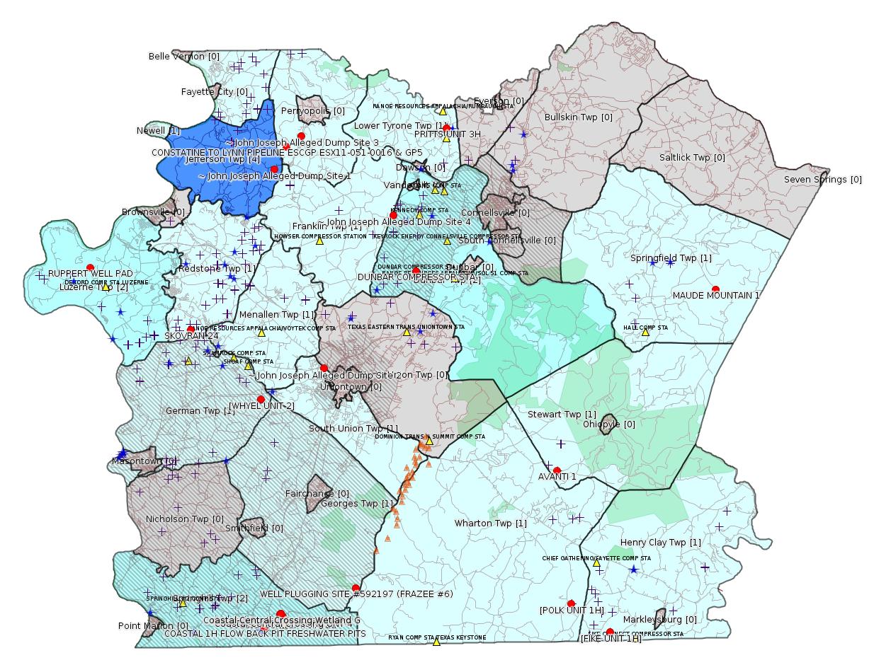
Map
Key
Red dots: items in this permit list with an exact location.
Blue stars: Marcellus Gas Well Water Sources.
Municipality shading: number of "facilities", with each well counting separately
(includes the red dots):
Red dots: items in this permit list with an exact location.
Blue stars: Marcellus Gas Well Water Sources.
Municipality shading: number of "facilities", with each well counting separately
(includes the red dots):
gray: 0
pale turquoise: 1
turquoise: 2
pale blue: 3
middle blue: 4
dark blue: 6
dark purple: 10
purple: 19
(Color coding may differ from one issue to the next.)
(Note if a project spans multiple municipalities -- e.g. a pipeline -- it will show in the count for each municipality.)
The number of facilities also follows the municipality name in brackets.
Municipality counts are based on the way the permit is listed by DEP; DEP has been known to get a municipality wrong.
Locations in brackets identify a precise location used to locate a surrogate for the actual site being permitted (e.g. locating a well pad or pipeline by the known location of a well.) Locations labeled beginning with "~" and ending in "[?]" are approximate and speculative based on inferences using on-line property and lease records. These are marked in the text as "[Approximate, Speculative]
Cross-hatching: Environmental Justice Areas
Yellow triangles: Compressor Stations
Orange triangles: Storage Field Wells (currently Dominion North Summit Storage Field)
Crosses: Unconventional well permits (may not have been drilled)
Green: "Natural areas", e.g. state game lands, state forests
Yellow triangles: Compressor Stations
Orange triangles: Storage Field Wells (currently Dominion North Summit Storage Field)
Crosses: Unconventional well permits (may not have been drilled)
Green: "Natural areas", e.g. state game lands, state forests
More Maps
 |
 |
Source: Pennsylvania Bulletin
63174001. Geokinetics (1000 Commerce Circle, Trafford, PA 15085). Blasting activity permit for the Arran 3D, to conduct seismic activity located in Donor, North Charleroi, Charleroi, Speers, Dunlevy, Stockdale, Roscoe, Elco, Bentleville, Centerville and West Brownsville Boroughs, Carroll, Fallowfield, Twilight, Long Branch, Allenport, California, and West Pike Run Townships, Washington County; Monessen and North Belle Vernon Boroughs, Rostraver Township, Westmoreland County; Washington, Jefferson and Newel Townships, Fayette City, Fayette County with an expiration date of March 30, 2018. Blasting permit issued: March 20, 2017.
<http://www.pabulletin.com/secure/data/vol47/47-14/577c.html>
---
NOTICES
DEPARTMENT OF CONSERVATION AND NATURAL RESOURCES
Execution of Oil and Gas Lease for Publicly-Owned Streambeds
[47 Pa.B. 2190]
[Saturday, April 15, 2017]
Effective August 9, 2016, an Oil and Gas Lease for Publicly-Owned Streambeds, Contract No. M-2102032-04, was executed by and between the Commonwealth, acting through the Department of Conservation and Natural Resources (Department) (lessor), and EQT Production Company (lessee), with its principal place of business located at 625 Liberty Avenue, Pittsburgh, PA 15222.
The lease is for Streambed Tract 2032 on the Monongahela River encompassing a total of 553 acres of submerged lands located in Carroll, Monongahela, Union, Luzerne, Forward, Jefferson and Rices Landing Townships, Greene, Fayette, Washington and Allegheny Counties. The lease was recorded at the Allegheny County Courthouse on September 19, 2016, document No. 2016-29397, Bk-DE VI-16540, page 95; the Fayette County Courthouse on January 11, 2017, instrument No. 201700000404, book 3329, page 2415; the Greene County Courthouse on December 2, 2016, instrument No. 201600007325, book 496, pages 2216—2246; and the Washington County Courthouse on September 19, 2016, instrument No. 201623799. The lease allows for the development of oil and natural gas below and between the ordinary low water marks of the Monongahela River solely by means of directional, including horizontal, drilling on a nondevelopment basis that will not disturb the river or its bed. Contract No. M-2102032-04 may be viewed online at http://contracts.patreasury.gov/admin/Upload/373228_M-2102032-04%20Streambed%20Lease%20Tract%202032%20Monongahela%20River%20EQT.pdf.
Questions regarding this lease should be directed to the Department's Bureau of Forestry, Minerals Division, (717) 787-2703.
CINDY ADAMS DUNN,
Secretary
<http://www.pabulletin.com/secure/data/vol47/47-15/623.html>
---
Applications received under sections 5 and 402 of The Clean Streams Law (35 P.S. §§ 691.5 and 691.402)
Southwest Region: Oil and Gas Management Program Manager, 400 Waterfront Drive, Pittsburgh PA, 15222.
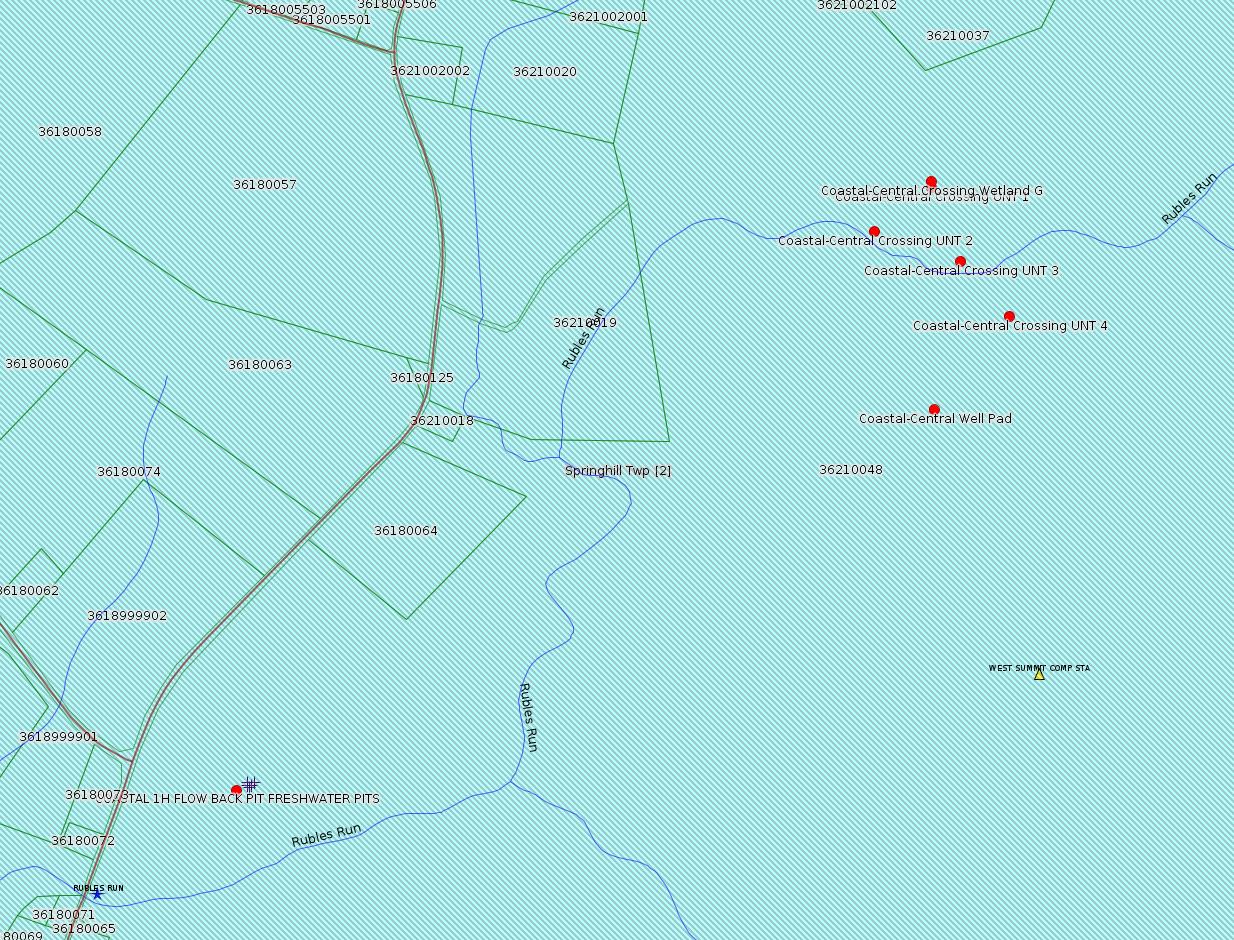
E26-07-005: Burnett Oil Company, Inc., 801 Cherry Street, Unity 9, Fort Worth, TX 76102, Springhill Township, Fayette County, ACOE Pittsburgh District.
Burnett Oil Company, Inc. is proposing to install 0.99 mile of permanent gravel access road and the 119,500 square foot Coastal-Central Well Pad (N 39° 44` 21.48", W 79° 47` 10.68") in Springhill Township, Fayette County, Pennsylvania. The well pad is located approximately 0.59 mile Southwest of State Route 3004 (Wymps Gap Road) and approximately 0.59 mile East of State Route 857 (Springhill Furnace Road). The proposed access road will be 16 feet wide with additional spaces required for road construction and stormwater management.
The entire project area is approximately 23.3 acres and consists primarily of meadow and woodlands. Four individuals of the tree species Oxydendrum arboreum (Sourwood) was found in the project area and, per a letter from the Department of Conservation and Natural Resources (DCNR), will be relocated to an area outside of the limit of disturbance. All disturbed areas except for the described access road and well pad will be stabilized and seeded upon construction completion. The project is a Joint Permit Application due to the crossing of a stream where the drainage area is greater than 1 square mile (based on USGS Stream Stats). The project will result in one (1) wetland crossing and five (5) watercourse crossings, resulting in a total of 871 ft2 of permanent wetland impacts and 348 linear feet of permanent stream impacts.
Each of the following crossings will be crossed by the permanent access road mentioned above:
Wetland Crossing
Latitude/Longitude Area of Impact
Wetland G
Palustrine Emergent (PEM) Lat: N 39.7430,
Long: W 79.7863 Temporary: 0.0 acre
Permanent: 0.02 acre
Stream Crossings
Latitude/Longitude Area of Impact
UNT 1 to Rubles Run (CWF) Lat: N 39.7429,
Long: W 79.7863
Temporary: 410 ft2
Permanent: 310 ft2
UNT 2 to Rubles Run (CWF) Lat: N 39.7422,
Long: W 79.7875
Temporary: 136 ft2
Permanent: 168 ft2
Stream Crossings
Latitude/Longitude Area of Impact
UNT 3 to Rubles Run (CWF) Lat: N 39.7417,
Long: W 79.7857
Temporary: 438 ft2
Permanent: 1,149 ft2
Rubles Run (CWF) Lat: N 39.7416,
Long: W 79.7855 Temporary: 714 ft2
Permanent: 1,875 ft2
UNT 4 to Rubles Run (CWF) Lat: N 39.7408
Long: W 79.7847 Temporary: 290 ft2
Permanent: 1,640 ft2
This permit contains the following special permit conditions:
1. The permittee shall avoid wetland areas for use as staging areas or to store equipment and supplies.
2. Prior to the start of earthmoving activities, all wetlands that are not authorized for impact by this permit shall be clearly marked in the field with orange construction fencing or other similar highly visible material.
3. The permittee and his agents will be watchful for archaeological artifacts and will assure that ground disturbance activities will cease immediately upon discovery of archaeological artifacts, and immediately notify the DEP Regional Office and the Pennsylvania Historical and Museum Commission at P.O. Box 1026, Harrisburg, PA 17120-1026, telephone (717) 783-8947.
<http://www.pabulletin.com/secure/data/vol47/47-15/626b.html>
Presumed Parcel Id: 36210048
---
E56-381, Columbia Gas Transmission, LLC, 1700 MacCorkle Avenue, S.E., Charleston, WV 25314, Addison Township and Elk Lick Township, Somerset County, ACOE Pittsburgh District.
Has been given consent to:
The proposed project starts approximately 2.25 miles south of the US Route 40 bridge over the Youghiogheny River in Addison Township, Somerset County (Friends-ville, MD, PA, WV Quadrangle N: 39°, 43`, 18"; W: -79°, 23`, 32") and ends approximately 0.7 mile southwest of the intersection of State Route 669 and Ash Hill Road in Elk Lick Township, Somerset County (Grantsville, MD, PA Quadrangle N: 39°, 43`, 22"; W: -79°, 10`, 18"). In Somerset County, the project consists of the construction and maintenance of an approximately 475 LF temporary road crossing of wetland W74A (EV) and an approximately 480 LF temporary road crossing of wetland W72 (EV), Sub basin 19F; Zehner Run Watershed (HQ-CWF). In addition, the proposed project impacts in Somerset County also include a total of five (5) pipeline crossings through the construction of a 0.65-mile-long 2-inch lateral pipeline, the removal of ten (10) pipeline crossings, grouting of seven (7) pipeline crossings, the removal of one (1) valve within a wetland, the removal of one (1) tap within a wetland, and the operation of maintenance of some segments of the existing line 138 within an existing Right-of-Way where service will be abandoned in Addison and Elk Lick Townships, which will be constructed in accordance with the terms and conditions of General Permit No. 11 (GP-11) regarding maintenance of existing water obstructions and General Permit No. 8 (GP-8) regarding temporary road crossings. These structures and activities will cumulatively affect approximately 1898LF of watercourses including Collier Run (WWF) and Zehner Run (HQ-CWF), and unnamed tributaries of Chub Run (WWF), Mill Run (WWF), Zehner Run (HQ-CWF), Big Shade Run (CWF), and Youghiogheny Lake (WWF) and 1.05 acre of wetlands (including the aforementioned wetland). The aforementioned proposed project impacts in this permit application are associated with a larger proposed, approximately 33 mile transmission pipeline service abandonment project, with portions extending into Somerset and Fayette Counties, in Pennsylvania. For more detailed information regarding the Chapter 105 permit application related to this proposed project, which is available in the DEP regional office, please contact the Waterways and Wetlands Program Manager, Rita Coleman at 412-442-4149 to request a file review.
<http://www.pabulletin.com/secure/data/vol47/47-15/626d.html>
-------------------------
Source: eNOTICE (+ PA Oil and Gas Mapping, Well Pad Report) Please see the Disclaimer below regarding Parcel Id data.
Authorization ID: 1175717
Permit number: 051-24062
Site: SKOVRAN 24 OG WELL
Client: CHEVRON APPALACHIA LLC
Authorization type: Well Plugging Notice Intent to Plug Single Well
Application type: New
Authorization is for: FACILITY
Date received: 03/30/2017
Status: Issued on 3/30/2017
Sub-Facility ID Sub-Facility Name Description
974880 SKOVRAN 24 Well
<http://www.ahs.dep.pa.gov/eFACTSWeb/searchResults_singleAuth.aspx?AuthID=1175717>
Location: 39.937693,-79.862935 <http://osm.org/go/ZWpacnl2--?m=>
Municipalities: Redstone Twp
Presumed Parcel Id: 30330064
SPUD Date: 9/30/2008
Conservation Well: Y
Coal: Coal
Well Details Report Record:
<https://www.paoilandgasreporting.state.pa.us/publicreports/Modules/WellDetails/WellDetails.aspx?PermitNumber=051-24062>
Most Recent Production Period: Jan - Jun 2013 -- Gas Qty (Mcf): 6157
Authorization ID: 1176640
Permit number:
Site: SKOVRAN 24 OG WELL
Client: CHEVRON APPALACHIA LLC
Authorization type: Residual Waste Processing
Application type: New
Authorization is for: FACILITY
Date received: 04/06/2017
Status: Issued on 4/6/2017
Sub-Facility ID Sub-Facility Name Description eMap PA Location
1231302 SKOVRAN 24 ALT RW Residual Waste Processing Locations
<http://www.ahs.dep.pa.gov/eFACTSWeb/searchResults_singleAuth.aspx?AuthID=1176640>
Authorization ID: 1176035
Permit number: ESX17-051-0002
Site: RUPPERT WELL PAD ESCGP ESX17-051-0002
Client: CHEVRON APPALACHIA LLC
Authorization type: Expedited E&S Stormwater General Permit 1
Application type: New
Authorization is for: SITE
Date received: 03/31/2017
Status: Pending
Permit Review Notes:
Date Review Note
4/7/2017 Applicant has been issued a deficiency letter. If applicable, this application no longer qualifies for the Permit Decision Guarantee.
<http://www.ahs.dep.pa.gov/eFACTSWeb/searchResults_singleAuth.aspx?AuthID=1176035>
Location: 39.980714,-79.951394 <http://osm.org/go/ZWpZcmDI--?m=>
Municipalities: Luzerne Twp
Act 14 Notification: <http://faymarwatch.org/documents/SKM_554e17041316431.pdf>
Presumed Parcel Id: 19150099
[See Notes.]
Authorization ID: 1176609
Permit number:
Site: PRITTS UNIT 2 OG WELL
Client: CHEVRON APPALACHIA LLC
Authorization type: Residual Waste Processing
Application type: New
Authorization is for: FACILITY
Date received: 03/29/2017
Status: Issued on 4/6/2017
Sub-Facility ID Sub-Facility Name Description
1231276 PRITTS UNIT ALT RW Residual Waste Processing Locations
<http://www.ahs.dep.pa.gov/eFACTSWeb/searchResults_singleAuth.aspx?AuthID=1176609>
Well Pad Id: 149098
Wells on this pad:
051-24257 PRITTS UNIT 3H
Municipalities: Lower Tyrone Twp
Presumed Parcel Id: 18080013
[Following individual well details are for PRITTS UNIT 3H, which is the only well on this pad -jr.]
Location: 40.073017,-79.633347 <http://osm.org/go/ZWp3~g4H--?m=>
SPUD Date: 7/8/2010
Conservation Well: Y
Coal: Coal
Well Details Report Record:
<https://www.paoilandgasreporting.state.pa.us/publicreports/Modules/WellDetails/WellDetails.aspx?PermitNumber=051-24257>
Authorization ID: 1176627
Permit number:
Site: AVANTI 1 OG WELL
Client: CHEVRON APPALACHIA LLC
Authorization type: Residual Waste Processing
Application type: New
Authorization is for: FACILITY
Date received: 03/29/2017
Status: Issued on 4/6/2017
Sub-Facility ID Sub-Facility Name Description
1231296 AVANTI ALT RW Residual Waste Processing Locations
<http://www.ahs.dep.pa.gov/eFACTSWeb/searchResults_singleAuth.aspx?AuthID=1176627>
Location: 39.837527,-79.54003 <http://osm.org/go/ZWpuQBy2--?m=>
Municipalities: Stewart Twp
Presumed Parcel Id: 37150002
Wells on this pad:
051-23958 AVANTI 1
SPUD Date: 5/16/2008
Well Status: Regulatory Inactive Status
Conservation Well: Y
Well Configuration: Vertical Well
Coal: Coal
Well Details Report Record:
<https://www.paoilandgasreporting.state.pa.us/publicreports/Modules/WellDetails/WellDetails.aspx?PermitNumber=051-23958>
Most Recent Production Period: *Never*
[See Notes.]
Authorization ID: 1174460
Permit number: GP07260717-001
Site: WELL PLUGGING SITE #592197 (FRAZEE #6) GP07260717-001
Client: EQT PRODUCTION CO
Authorization type: GP-07 Minor Road Crossings
Application type: New
Authorization is for: FACILITY
Date received: 02/09/2017
Status: Pending
Sub-Facility ID Sub-Facility Name Description
1230220 FRAZEE WELL PLUGGING #6 GP07260717-001 Floodway Activity
<http://www.ahs.dep.pa.gov/eFACTSWeb/searchResults_singleAuth.aspx?AuthID=1174460>
Location: 39.759788,-79.719995 <http://osm.org/go/ZWpg_inI--?m=>
Municipalities: Georges Twp [an Environmental Justice Area]
Authorization ID: 1174654
Permit number: GP05260717-001
Site: LPR MIDSTREAM PARTNERS LLC POLK PIPELINE ESCGP ESG17-051-0001 & GP05 GP08
Client: LPR MIDSTREAM PARTNERS LLC
Authorization type: GP-05 Utility Line Stream Crossings
Application type: New
Authorization is for: FACILITY
Date received: 03/01/2017
Status: Pending
Sub-Facility ID Sub-Facility Name Description
1230294 POLK PIPELINE PROJECT GP05260717-001 Pipeline or Conduit
Permit Review Notes:
Date Review Note
4/10/2017 Applicant has been issued a deficiency letter. If applicable, this application no longer qualifies for the Permit Decision Guarantee.
<http://www.ahs.dep.pa.gov/eFACTSWeb/searchResults_singleAuth.aspx?AuthID=1174654>
Municipalities: Henry Clay Twp, Wharton Twp
Location [of POLK UNIT 1H]: 39.746494,-79.529567 <http://osm.org/go/ZWpqHRIj--?m=>
Presumed Parcel Id: 4233000106
Location [of FIKE UNIT 1H]: 39.727028 -79.495752 <http://osm.org/go/ZWpqgA7n--?m=>
Parcel Id: 16190003
[See Notes.]
Authorization ID: 1174655
Permit number: GP08260717-001
Site: LPR MIDSTREAM PARTNERS LLC POLK PIPELINE ESCGP ESG17-051-0001 & GP05 GP08
Client: LPR MIDSTREAM PARTNERS LLC
Authorization type: GP-08 Temporary Road Crossings
Application type: New
Authorization is for: FACILITY
Date received: 03/01/2017
Status: Pending
Sub-Facility ID Sub-Facility Name Description
1230296 POLK PIPELINE PROJECT GP08260717-001 Bridge
Permit Review Notes:
Date Review Note
4/10/2017 Applicant has been issued a deficiency letter. If applicable, this application no longer qualifies for the Permit Decision Guarantee.
<http://www.ahs.dep.pa.gov/eFACTSWeb/searchResults_singleAuth.aspx?AuthID=1174655>
Authorization ID: 1100685
Permit number: ESX10-051-0035
Site: COASTAL 1H FLOW BACK PIT FRESHWATER PITS ESCGP-EXPEDITED
Client: BURNETT OIL CO INC
Authorization type: Expedited E&S Stormwater General Permit 1
Application type: Amendment
Authorization is for: SITE
Date received: 12/08/2015
Status: Pending
Permit Review Notes:
Date Review Note
12/21/2016 Applicant has been issued a deficiency letter. If applicable, this application no longer qualifies for the Permit Decision Guarantee.
4/6/2016 Applicant has been issued a deficiency letter. If applicable, this application no longer qualifies for the Permit Decision Guarantee.
3/31/2016 Applicant has been issued a deficiency letter. If applicable, this application no longer qualifies for the Permit Decision Guarantee.
<http://www.ahs.dep.pa.gov/eFACTSWeb/searchResults_singleAuth.aspx?AuthID=1100685>
Location: 39.733294,-79.801028 <http://osm.org/go/ZWpgBJ2N--?m=>
Municipalities: Springhill Twp [an Environmental Justice Area]
Presumed Parcel Id: 36210048
Well Pad Id: 147971
Wells on this pad:
051-24318 COASTAL 1H
051-24382 COASTAL/SMITH UNIT 1H
Authorization ID: 1161814
Permit number: ESX11-051-0017
Site: WHYEL UNIT PREVIOUSLY SUMEY 1H ESCGP-EXPEDITED
Client: BURNETT OIL CO INC
Authorization type: Expedited E&S Stormwater General Permit 1
Application type: Amendment
Authorization is for: SITE
Date received: 06/08/2016
Status: Issued on 4/11/2017
Permit Review Notes:
Date Review Note
3/29/2017 Applicant has been issued a deficiency letter. If applicable, this application no longer qualifies for the Permit Decision Guarantee.
3/29/2017 Applicant has been issued a deficiency letter. If applicable, this application no longer qualifies for the Permit Decision Guarantee.
2/21/2017 Applicant has been issued a deficiency letter. If applicable, this application no longer qualifies for the Permit Decision Guarantee.
<http://www.ahs.dep.pa.gov/eFACTSWeb/searchResults_singleAuth.aspx?AuthID=1161814>
Location [of WHYEL UNIT 2]: 39.889344,-79.80168 <http://osm.org/go/ZWplRYcV--?m=>
Municipalities: German Twp [an Environmental Justice Area]
Presumed Parcel Id: 15290036
Authorization ID: 1174700
Permit number: GP05260717-002
Site: CONSTATINE TO LYNN PIPELINE ESCGP ESX11-051-0016 & GP5
Client: LAUREL MTN MIDSTREAM OPR LLC
Authorization type: GP-05 Utility Line Stream Crossings
Application type: New
Authorization is for: FACILITY
Date received: 03/03/2017
Status: Issued on 4/12/2017
Sub-Facility ID Sub-Facility Name Description
1231646 CONSTANTINE TO LYNN PIPELINE GP05260717-002 Pipeline or Conduit
1230346 CONSTANTINE TO LYNN PIPELINE GP05260717-002 Pipeline or Conduit
<http://www.ahs.dep.pa.gov/eFACTSWeb/searchResults_singleAuth.aspx?AuthID=1174700>
Location: 40.061863,-79.776075 <http://osm.org/go/ZWp1Zgsy--?m=>
Municipalities: Franklin Twp, Jefferson Twp, Menallen Twp
[See Notes.]
[Repeat Listing]
Authorization ID: 1173963
Permit number: GP5-26-00584E
Site: DUNBAR COMPRESSOR STA
Client: LAUREL MTN MIDSTREAM OPR LLC
Authorization type: AQ GP 5 - Natural Gas Compression and/or Processing Facilities
Application type: New
Authorization is for: FACILITY
Date received: 03/07/2017
Status: Pending
<http://www.ahs.dep.pa.gov/eFACTSWeb/searchResults_singleAuth.aspx?AuthID=1173963>
Municipalities: Dunbar Twp
Location: 39.975576,-79.662295 <http://osm.org/go/ZWpzxuzL--?m=> [an Environmental Justice Area]
Presumed Parcel Id: 0920019903
Fayette County Act 14 Notification: <http://faymarwatch.org/documents/SKM_554e17041316430.pdf>
[See Notes.]
-------------------------
Source: DEP Oil and Gas Electronic Notifications
NOTIFICATION_ID: 33890
OGO: 39307
OPERATOR: CHEVRON APPALACHIA LLC
API_PERMIT: 051-24257
SPUD_DATE: 07/08/2010
COUNTY: Fayette
MUNICIPALITY: Lower Tyrone
LATITUDE: 40.073017
LONGITUDE: -79.633347
SUBJECT: [NOTIFICATION]: Abandonment or plugging notification 58 Pa. C.S. 3211(f)(2) for well API 37-051-24257-00-00
QUESTION: Date and approximate time action is to occur
ANSWER: Date: 04/10/2017 Time: 9:30AM
SENT_DATE: 4/6/2017 7:44:00 AM
SENT_SUCCESS: Yes
LAST_RESENT_DATE:
RESENT_SUCCESS:
Comments:
Farm Name: PRITTS UNIT 3H
[Location above.]
-------------------------
Source: DEP Oil and Gas Compliance Report
[Conventional Well:]
OPERATOR: CNX GAS CO LLC
INSPECTION_ID: 2580646
INSPECTION_DATE: 03/24/2017
INSPECTION_TYPE: Incident- Response to Accident or Event
API_PERMIT: 051-20200
FARM_NAME: MAUDE MOUNTAIN 1
UNCONVENTIONAL: N
SITE_ID: 41098
SITE_NAME: MAUDE MTN 1 WELL
FACILITY_TYPE: Oil & Gas Location
INSPECTION_CATEGORY: Primary Facility
REGION: EP DOGO SWDO Dstr Off
COUNTY: Fayette
MUNICIPALITY: Springfield Twp
INSPECTOR: NAJEWICZ, JUSTIN
INSPECTION_RESULT_DESCRIPTION: In Compliance with Policy
INSPECTION_COMMENT: On 03/21/17 a spill of approximately 20 gallons occurred. The brine tanks were immediately drained and moved. The impacted material was removed and the brine tanks were replaced. The disturbed location was stabilized at the time of inspection.
Location: 39.959746,-79.396764 <http://osm.org/go/ZWrRmHQc--?m=>
Presumed Parcel Id: 35160013
Lease Parcel Id: 35160013GW
Well Details Report Record:
<https://www.paoilandgasreporting.state.pa.us/publicreports/Modules/WellDetails/WellDetails.aspx?PermitNumber=051-20200>
[See Notes.]
-------------------------
Source: Uniontown Herald-Standard [Repeat, revised]
According to the 3/30/17 issue of the Uniontown Herald Standard, John Ashley Joseph of Connellsville faces 21 counts of illegal dumping at 5 different locations. This is apparently an investigation by the Office of Attorney General, and an outgrowth of a DEP investigation which resulted in a citation by DEP. Mr. Joseph appealed that citation, and several others, in cases before the Environmental Hearing Board, which have been consolidated under EHB case number 2015046; for the docket sheet in that case, see:
<http://ehb.courtapps.com/public/document_shower_pub.php?docketNumber=2015046>
This case has been covered several times in this bulletin, see:
<http://www.faymarwatch.org/happening/permits/012416.shtml#Joseph>
<http://www.faymarwatch.org/happening/permits/082315.shtml#Joseph>
<http://www.faymarwatch.org/happening/permits/100415.shtml#Joseph>
Proceedings in the EHB case were stayed on 2/5/2016 pending the outcome of the Attorney General's investigation -- see case documents 18 and 19:
<http://ehb.courtapps.com/efile/documentViewer.php?documentID=29857>
<http://ehb.courtapps.com/efile/documentViewer.php?documentID=29858>
<http://ehb.courtapps.com/efile/documentViewer.php?documentID=29864>
The Docket Sheet for the criminal case against Mr. Joseph can be found here:
<https://ujsportal.pacourts.us/DocketSheets/MDJReport.ashx?docketNumber=MJ-14304-CR-0000138-2017>
The Uniontown Herald-Standard article can be found here:
<http://www.heraldstandard.com/news/hsnewsnow/investigation-reveals-oil-and-gas-drilling-waste-dumped-at-local/article_ec3b9a18-12ae-5b25-89ef-2aa5f78d7d45.html>
All dump site locations shown below are approximate. The first location was determined based on the EHB case documents; the others were geolocated based on addresses taken from the Uniontown Herald-Standard article. (Location for Site 5 is too vague to map.)
Location (Site 1) [approximate]: 40.046520,-79.786988 <http://osm.org/go/ZWp1Gh7r--?m=>
Location (Site 2) [approximate]: 39.910008, -79.745298 <http://osm.org/go/ZWpwjPDu--?m=>
Location (Site 3) [approximate]: 40.069206,-79.762616 <http://osm.org/go/ZWp1etiE--?m=>
Location (Site 4) [approximate]: 40.014028,-79.681737 <http://osm.org/go/ZWp2aGxD--?m=>
-------------------------
Source: Reuters Commodities: Energy
Natural Gas
| Commodity | Exchange | Currency | Expire | Last Trade | Trade Time | Change | Open | Day's High | Day's Low |
|---|---|---|---|---|---|---|---|---|---|
| NATURAL
GAS CON1 Apr17 |
NYM | USD | 04/26 | 3.15 | 04/18 01:20 | -0.01 | 3.16 | 3.17 | 3.15 |
-------------------------
Notes:
The Ruppert Well Pad is apparently the first new well pad permit from Chevron in Fayette County in many months. Latitude and longitude information above are taken from the Act 14 notification. Act 14 is a state law requiring notification of counties and municipalities of intent to apply to DEP for several kinds of permits; these include Erosion & Sedimentation (E&S) Permits for well pads, E&S permits for pipelines, and Air Quality permits (including General Permits). Counties and Municipalities are supposed to get a 30 day comment period on all permits subject to Act 14 notifications, even if there is no "general" public comment on such permits. The Act 14 Notification link above is to faymarwatch.org; the copy of the notification was provided thanks to the Fayette County Office of Planning, Zoning, and Community Development. Act 14 notifications for well pad E&S permits are required to include an NOI (Notice of Intent) form from DEP with required boxes for latitude and longitude; this geolocation is the earliest precise location available anywhere for new unconventional wells. Act 14 NOIs are typically not available on-line.
The Ruppert Well Pad notification appears to show this is planned for 10 wells. The favored direction for drilling Marcellus horizontal wells in our area is approximately northwest to southeast. Precise GIS coordinates for the horizontal may be typically found by locating latitude and longitude for the "landing point" and the "bottom hole" on the plat. For "newer" wells the plat is available at DEP Oil & Gas Mapping, and where available is shown in this bulletin by the link to "Full Permit" under the original Drill & Operate Well permit.
The presumed parcel for the Ruppert Well Pad also appears to include a conventional well known as J ROBISON 1, permit # 051-24168. (This well is apparently still in production.)
---
The Avanti 1 well site was the site of several violations dating to 2008 and 2009. For details see:
<http://www.ahs.dep.pa.gov/eFACTSWeb/searchResults_singleViol.aspx?InspectionID=1712825>
<http://www.ahs.dep.pa.gov/eFACTSWeb/searchResults_singleViol.aspx?InspectionID=1847524>
Fines assessed were 8400 and 7425.
---
Locations for POLK UNIT 1H and FIKE UNIT 1H are exact; it's speculation that these correctly locate the ends of the pipeline applied for as LPR MIDSTREAM PARTNERS LLC POLK PIPELINE ESCGP ESG17-051-0001 above.
---
The "point" location mapped regarding authorization 1174700 above in the Constantine to Lynn pipeline project shows the location of a single conduit; the site municipalities apparently reflect the extent of the whole pipeline. (DEP does not typically publish GIS data for pipeline Erosion & Sedimentation permits.)
---
When the inspection report field "INSPECTION_RESULT_DESCRIPTION" shows as "In Compliance with Policy", this is apparently a violation which has been remediated by the time the inspector arrives. Note these inspections are NOT retrieved if you search inspection reports for violations only.
The parcel marked "Lease Parcel Id" for MAUDE MOUNTAIN 1 above actually shows pictures of the well. However it is not mapped on the Fayette County Tax Assessment Office Property Search web site, so (as usual) the parcel marked "Presumed Parcel Id" -- which is mapped -- is the enclosing parcel.
---
The "point" location mapped regarding authorization 1174700 above in the Constantine to Lynn pipeline project shows the location of a single conduit; the site municipalities apparently reflect the extent of the whole pipeline. (DEP does not typically publish GIS data for pipeline Erosion & Sedimentation permits.)
---
The latitude/longitude for the Dunbar Compressor Station appears in DEP records as: 39.985868,-79.664650. This is apparently incorrect. The parcel record shown above, 0920019903, is clearly the location of a compressor station, and the billing address for property taxes on this parcel is evidently a Williams address.
The Act 14 notification (as well as the DEP site record) lists the address of this facility as 538 Monarch Road, which we believe to be incorrect. It appears from the Act 14 notification that there are two reasons for the application for GP5-26-00584E: GP5-26-00584D (the existing permit) is due to expire on May 16, 2017, and one gas-fired compression engine is being removed, leaving one 1340 hp gas-fired engine, one 3000 hp electric engine, and one dehydrator, among other equipment. (See the Act 14 notification for Laurel Mountain Midstream's equipment list.)
The Act 14 notification was provided thanks to the Fayette County Office of Planning, Zoning, and Community Development.
------------------------
DEP defines an environmental justice area as "any census tract where 20 percent or more individuals live in poverty, and/or 30 percent or more of the population is minority". (See:
<http://www.dep.pa.gov/PublicParticipation/OfficeofEnvironmentalJustice/Pages/default.aspx>). There are supposed to be enhanced public participation requirements for permits in environmental justice areas, but news of this actually ever happening is scarce. In Fayette County, the entirety of Springhill, Nicholson, German, and Georges Townships are environmental justice areas, as well as a large part of Dunbar Township. DEP's policy document on public participation guidelines for environmental justice areas is located here:
<http://www.elibrary.dep.state.pa.us/dsweb/Get/Version-48671/012-0501-002.pdf>
eNOTICE records are likely to list the same permit multiple times, as that permit moves through the DEP process.
Oil & Gas Wells designated with a site a number and the letter H typically designate horizontal wells.
-------------------------
Resources:
Pennsylvania Bulletin: <http://www.pabulletin.com/>
eNOTICE: <http://www.ahs2.dep.state.pa.
DEP Oil and Gas Reports: <http://www.dep.pa.gov/DataandTools/Reports/Oil%20and%20Gas%20Reports/Pages/default.aspx>
DEP Well Details Report: <https://www.paoilandgasreport
Well Details may not show any
information for new permits and will not show permits which have
not yet been issued. Lookup for Well Details is by permit number.
DEP Permits Issued Detail Report:
<http://www.depreportingservic
DEP SPUD (drilling started) Report:
<http://www.depreportingservices.state.pa.us/ReportServer/Pages/ReportViewer.aspx?/Oil_Gas/Spud_External_Data>
DEP Oil and Gas Compliance Report:
<http://www.depreportingservices.state.pa.us/ReportServer/Pages/ReportViewer.aspx?/Oil_Gas/OG_Compliance>
DEP PA Oil & Gas Mapping:
<http://www.depgis.state.pa.us/PaOilAndGasMapping>
DEP Oil and Gas Electronic Notifications
<http://www.depreportingservices.state.pa.us/ReportServer?/Oil_Gas/OG_Notifications>
DEP Oil and Gas Well Pad Report
<http://www.depreportingservices.state.pa.us/ReportServer?/Oil_Gas/Well_Pads>
Fayette County Assessment Office Search For Tax Records:
<http://property.co.fayette.pa.us/search.aspx>
Pennsylvania Spatial Data Access:
<http://www.pasda.psu.edu/default.asp>
DEP Spatial Data Repository:
<ftp://www.pasda.psu.edu/pub/pasda/dep/>
National Response Center:
<http://www.nrc.uscg.mil/>
EPA-Echo: <http://www.epa-echo.gov/echo/
FERC citizen involvement: <http://www.ferc.gov/for-citiz
To receive E-mail notification of
all documents filed in a FERC docket, see:
<http://www.ferc.gov/docs-filing/esubscription.asp >
<http://www.ferc.gov/docs-fili
Follow the directions and enter the docket number to subscribe to.
Township Supervisors receive information regarding Erosion & Sedimentation permits, and these records may be reviewable at township municipal offices.
DEP permits are reviewable through the File Review process, for application to do file review see: <http://www.portal.state.pa.us/portal/server.pt/community/southwest_regional_office/13775/file_review/593164>
Environmental Hearing Board: <http://ehb.courtapps.com/publ
PA DEP Environmental Policy Comment System:
<http://www.ahs.dep.pa.gov/eComment/>
Federal Register Environment: <https://www.federalregister.g
Browsing of recent comment
opportunities for federal agencies, e.g. EPA. Click "sign up" to
subscribe to daily E-mails of new document listings.
SkyTruth Fayette County Drilling Alerts: <http://frack.skytruth.org/pen
U.S. Army Corps of Engineers, Pittsburgh District, Public Notices:
<http://www.lrp.usace.army.mil/Missions/Regulatory/Public-Notices/>
EPA Pennsylvania Public Notices: <http://www2.epa.gov/aboutepa/epa-pennsylvania#notice>
Marcellus Shale waste disposal
injection wells in Pennsylvania are regulated directly by EPA, not
DEP. Notice of any new permit applications will appear at the
above web address. I'm not aware of any subscription service
to be notified of such applications. I'm not aware of any
Marcellus Shale waste disposal injection wells in Fayette County
(yet ...) but we need to monitor this page for future
applications.
Energy Assurance Daily: <http://www.oe.netl.doe.gov/ead.aspx>
Daily newsletter from the US
Department of Energy about events relating to energy. The Natural
Gas section has information about pipelines.
-------------------------
Disclaimers:
This compilation from the above sources was done by hand using copy and paste and may omit relevant permits.
Parcel data is provided via the tax records search web page offered by the Fayette County Assessment Office (http://property.co.fayette.pa.us/). Presumed Parcel Id links are subject to availability provided by that agency and associated web sites. Presumed Parcel Ids are determined as the mapped parcel containing a given latitude and longitude, are a best effort determination which is subject to error, and are not official. In cases where a facility is leased and there is a separate parcel id for the lease, if this parcel id is not separately mapped, the parcel id shown will be the id for the enclosing parcel. Parcel owners may be surface owners only and may or may not have any relationship to oil & gas facilities.
Does not currently include water supply permits. Does not include landfill permits even though many such are for Marcellus Shale waste. (It is not possible at this time to distinguish which landfill permits are for Marcellus Shale waste and which are not without doing File Review for each permit.)
Erosion & Sedimentation permit records do not currently include latitude and longitude. Where I am publishing latitude and longitude with E&S permits it is by inferring an associated well permit and using published latitude and longitude for the well. It is possible I may be inferring the wrong well site.
Municipalities are shown from eFACTS records on the DEP web site. The DEP has been known to list a municipality incorrectly.