The Harmed Success Stories Concepts How To What Is Commentary
Fayette County Marcellus Shale Permits 7/11/16 - 7/24/16
Click the map to enlarge
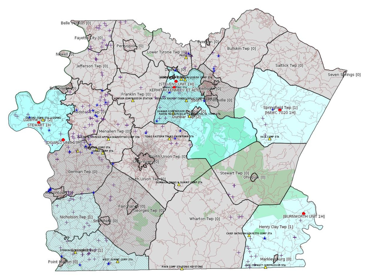
Map
Key
Red dots: items in this permit list with an exact location.
Blue stars: Marcellus Gas Well Water Sources.
Municipality shading: number of "facilities", with each well counting separately
(includes the red dots):
Red dots: items in this permit list with an exact location.
Blue stars: Marcellus Gas Well Water Sources.
Municipality shading: number of "facilities", with each well counting separately
(includes the red dots):
gray: 0
pale turquoise: 1
turquoise: 2
pale blue: 3
middle blue: 4
dark blue: 6
dark purple: 11
purple: 19
(Color coding may differ from one issue to the next.)
(Note if a project spans multiple municipalities -- e.g. a pipeline -- it will show in the count for each municipality.)
The number of facilities also follows the municipality name in brackets.
Municipality counts are based on the way the permit is listed by DEP; DEP has been known to get a municipality wrong.
Locations in brackets identify a precise location used to locate a surrogate for the actual site being permitted (e.g. locating a well pad or pipeline by the known location of a well.) Locations labeled beginning with "~" and ending in "[?]" are approximate and speculative based on inferences using on-line property and lease records. These are marked in the text as "[Approximate, Speculative]
Cross-hatching: Environmental Justice Areas
Yellow triangles: Compressor Stations
Crosses: Unconventional well permits (may not have been drilled)
Green: "Natural areas", e.g. state game lands, state forests
Yellow triangles: Compressor Stations
Crosses: Unconventional well permits (may not have been drilled)
Green: "Natural areas", e.g. state game lands, state forests
More Maps
 |
Source: Pennsylvania Bulletin
[No Activity]
-------------------------
Source: eNOTICE (+ PA Oil and Gas Mapping) Please see the Disclaimer below regarding Parcel Id data.
Authorization ID: 1142380
Permit number: 051-24244
Site: KERMIT M KENNEDY ET AL 6 OG WELL
Client: XTO ENERGY INC
Authorization type: Well Plugging Notice Intent to Plug Single Well
Application type: New
Authorization is for: FACILITY
Date received: 05/11/2016
Status: Issued on 7/6/2016
Sub-Facility ID Sub-Facility Name Description
993060 KERMIT M KENNEDY ET AL 6 Well
<http://www.ahs.dep.pa.gov/eFACTSWeb/searchResults_singleAuth.aspx?AuthID=1142380>
Municipalities: Dunbar Twp
Location: 40.017272,-79.65972 [an Environmental Justice Area] <http://osm.org/go/ZWp2yXlK--?m=>
Presumed Parcel ID: 09110006
Authorization ID: 1090372
Permit number: ESX11-051-0002
Site: SPRINGHILL CS TO BEZJAK PIPELINE ESGPX-EXPEDITED
Client: LAUREL MTN MIDSTREAM OPR LLC
Authorization type: Expedited E&S Stormwater General Permit 1
Application type: Notification
Authorization is for: SITE
Date received: 09/17/2015
Status: Issued on 7/8/2016
<http://www.ahs.dep.pa.gov/eFACTSWeb/searchResults_singleAuth.aspx?AuthID=1090372>
Municipalities: Nicholson Twp [an Environmental Justice Area], Springhill Twp [an Environmental Justice Area]
Authorization ID: 1136302
Permit number: 051-24621
Site: STEWART WELL SITE ESCGP-2 EXPEDITED
Client: CHEVRON APPALACHIA LLC
Authorization type: Alt Method of Equipping, Casing, or Venting Well
Application type: New
Authorization is for: FACILITY
Date received: 04/29/2016
Status: Pending
Sub-Facility ID Sub-Facility Name Description
1211522 STEWART 1H Well
<http://www.ahs.dep.pa.gov/eFACTSWeb/searchResults_singleAuth.aspx?AuthID=1136302>
Location: 39.962961,-79.946955 <http://osm.org/go/ZWpZPAL7--?m=>
Municipalities: Luzerne Twp
Presumed Parcel Id: 19250010
Conservation Well: N
SPUD Date: 9/2/2015
[See Notes.]
Authorization ID: 1129409
Permit number: ESX09-051-0013
Site: FAYETTE COUNTY PROJECT ESCGP-EXPEDITED MAWC 7020 PAD
Client: TRIANA ENERGY LLC
Authorization type: Expedited E&S Stormwater General Permit 1
Application type: Notification
Authorization is for: SITE
Date received: 03/03/2016
Status: Issued on 7/15/2016
<http://www.ahs.dep.pa.gov/eFACTSWeb/searchResults_singleAuth.aspx?AuthID=1129409>
Location [of MAWC 7020 1H]: 39.977794,-79.437139 <http://osm.org/go/ZWrRTb3C--?m=>
Municipalities: Springfield Twp
Presumed Parcel Id: 35130001
Authorization ID: 1130367
Permit number: ESX16-051-0001
Site: STEVENS UNIT 1H 2H ESCGP-2 EXPEDITED
Client: XTO ENERGY INC
Authorization type: Expedited E&S Stormwater General Permit 1
Application type: New
Authorization is for: SITE
Date received: 03/23/2016
Status: Pending
Permit Review Notes:
Date Review Note
7/18/2016 Applicant has been issued a deficiency letter. If applicable, this application no longer qualifies for the Permit Decision Guarantee.
7/12/2016 Applicant has been issued a deficiency letter. If applicable, this application no longer qualifies for the Permit Decision Guarantee.
<http://www.ahs.dep.pa.gov/eFACTSWeb/searchResults_singleAuth.aspx?AuthID=1130367>
Location [of STEVENS UNIT 1H]: 40.027158,-79.655672 <http://osm.org/go/ZWp22x0B--?m=>
Municipalities: Dunbar Twp
Presumed Parcel ID: 09050277
[See Notes.]
Authorization ID: 1091345
Permit number: ESX11-051-0034
Site: DICARLO WELL SITES ESCGP-EXPEDITED
Client: CHEVRON APPALACHIA LLC
Authorization type: Expedited E&S Stormwater General Permit 1
Application type: Amendment
Authorization is for: SITE
Date received: 10/01/2015
Status: Pending
Permit Review Notes:
Date Review Note
11/23/2015 Applicant has been issued a deficiency letter. If applicable, this application no longer qualifies for the Permit Decision Guarantee.
<http://www.ahs.dep.pa.gov/eFACTSWeb/searchResults_singleAuth.aspx?AuthID=1091345>
Location [of DICARLO UNIT 13H (surrogate)]: 39.934281,-79.895722 <http://osm.org/go/ZWpY72yi--?m=>
Municipalities: Luzerne Twp
Presumed Parcel ID: 19340017
Authorization ID: 1085677
Permit number: ESX10-051-0028
Site: BURNWORTH FRESHWATER IMPOUNDMENT ESCGP-EXPEDITED
Client: CHIEF OIL & GAS LLC
Authorization type: Expedited E&S Stormwater General Permit 1
Application type: Notification
Authorization is for: SITE
Date received: 08/13/2015
Status: Withdrawn on 7/20/2016
<http://www.ahs.dep.pa.gov/eFACTSWeb/searchResults_singleAuth.aspx?AuthID=1085677>
Location [of BURNWORTH UNIT 1H]: 39.808139,-79.390917 <http://osm.org/go/ZWrB22cP--?m=>
Municipalities: Henry Clay Twp
Presumed Parcel ID: 16090033
-------------------------
Source: Reuters Commodities: Energy
Natural Gas
| Commodity | Exchange | Currency | Expire | Last Trade | Trade Time | Change | Open | Day's High | Day's Low |
|---|---|---|---|---|---|---|---|---|---|
| NATURAL
GAS CON1 Jul16 |
NYM | USD | 07/27 | 2.81 | 07/24 19:04 | +0.03 | 2.78 | 2.82 | 2.78 |
-------------------------
Notes:
The Stewart Well Pad was the location of a cementing anomaly at Stewart 2H that was evidently so serious it caused Chevron to apply for inactive status on all the wells on this pad except for Stewart 1H. For details on the cementing problem, see the 5/15/16 issue of this bulletin here:
<http://www.faymarwatch.org/happening/permits/051516.shtml#Stewart>
---
[Repeat note from the 5/1/16 issue of this bulletin:] The Facility Record for STEVENS UNIT 1H,
<http://www.ahs.dep.pa.gov/eFACTSWeb/searchResults_singleFacility.aspx?FacilityID=735807>, shows:
Corrective Action/Tank Closure requirements remain outstanding for incidents in Inactive status.
(It actually shows in red on the eFACTS web page.) It's possible this "corrective action" is what the permit above is for, rather than new wells at this site.
------------------------
DEP defines an environmental justice area as "any census tract where 20 percent or more individuals live in poverty, and/or 30 percent or more of the population is minority". (See:
<http://www.portal.state.pa.us/portal/server.pt/community/pa_environmental_justice_areas/20991>
<http://www.portal.state.pa.us/portal/server.pt/community/dep_enhanced_public_participation_policy/20988>
). There are supposed to be enhanced public participation requirements for permits in environmental justice areas, but news of this actually ever happening is scarce. In Fayette County, the entirety of Springhill, Nicholson, German, and Georges Townships are environmental justice areas, as well as a large part of Dunbar Township. DEP's policy document on public participation guidelines for environmental justice areas is located here:
<http://www.elibrary.dep.state.pa.us/dsweb/Get/Version-48671/012-0501-002.pdf>
eNOTICE records are likely to list the same permit multiple times, as that permit moves through the DEP process.
Oil & Gas Wells designated with a site a number and the letter H typically designate horizontal wells.
-------------------------
Resources:
Pennsylvania Bulletin: <http://www.pabulletin.com/>
eNOTICE: <http://www.ahs2.dep.state.pa.
DEP Well Details Report: <https://www.paoilandgasreport
Well Details may not show any
information for new permits and will not show permits which have
not yet been issued. Lookup for Well Details is by permit number.
DEP Permits Issued Detail Report:
<http://www.depreportingservic
DEP SPUD (drilling started) Report:
<http://www.depreportingservices.state.pa.us/ReportServer/Pages/ReportViewer.aspx?/Oil_Gas/Spud_External_Data>
DEP Oil and Gas Compliance Report:
<http://www.depreportingservices.state.pa.us/ReportServer/Pages/ReportViewer.aspx?/Oil_Gas/OG_Compliance>
DEP PA Oil & Gas Mapping:
<http://www.depgis.state.pa.us/PaOilAndGasMapping>
Fayette County Assessment Office Search For Tax Records:
<http://property.co.fayette.pa.us/search.aspx>
Pennsylvania Spatial Data Access:
<http://www.pasda.psu.edu/default.asp>
DEP Spatial Data Repository:
<ftp://www.pasda.psu.edu/pub/pasda/dep/>
National Response Center:
<http://www.nrc.uscg.mil/>
EPA-Echo: <http://www.epa-echo.gov/echo/
FERC citizen involvement: <http://www.ferc.gov/for-citiz
To receive E-mail notification of
all documents filed in a FERC docket, see:
<http://www.ferc.gov/docs-filing/esubscription.asp >
<http://www.ferc.gov/docs-fili
Follow the directions and enter the docket number to subscribe to.
Township Supervisors receive information regarding Erosion & Sedimentation permits, and these records may be reviewable at township municipal offices.
DEP permits are reviewable through the File Review process, for application to do file review see: <http://www.portal.state.pa.us/portal/server.pt/community/southwest_regional_office/13775/file_review/593164>
Environmental Hearing Board: <http://ehb.courtapps.com/publ
PA DEP Environmental Policy Comment System:
<http://www.ahs.dep.pa.gov/eComment/>
Federal Register Environment: <https://www.federalregister.g
Browsing of recent comment
opportunities for federal agencies, e.g. EPA. Click "sign up" to
subscribe to daily E-mails of new document listings.
SkyTruth Fayette County Drilling Alerts: <http://frack.skytruth.org/pen
EPA Pennsylvania Public Notices: <http://www2.epa.gov/aboutepa/epa-pennsylvania#notice>
Marcellus Shale waste disposal
injection wells in Pennsylvania are regulated directly by EPA, not
DEP. Notice of any new permit applications will appear at the
above web address. I'm not aware of any subscription service
to be notified of such applications. I'm not aware of any
Marcellus Shale waste disposal injection wells in Fayette County
(yet ...) but we need to monitor this page for future
applications.
Energy Assurance Daily: <http://www.oe.netl.doe.gov/ead.aspx>
Daily newsletter from the US
Department of Energy about events relating to energy. The Natural
Gas section has information about pipelines.
-------------------------
Disclaimers:
This compilation from the above sources was done by hand using copy and paste and may omit relevant permits.
Parcel data is provided via the tax records search web page offered by the Fayette County Assessment Office (http://property.co.fayette.pa.us/). Presumed Parcel Id links are subject to availability provided by that agency and associated web sites. Presumed Parcel Ids are determined as the mapped parcel containing a given latitude and longitude, are a best effort determination which is subject to error, and are not official. In cases where a facility is leased and there is a separate parcel id for the lease, if this parcel id is not separately mapped, the parcel id shown will be the id for the enclosing parcel. Parcel owners may be surface owners only and may or may not have any relationship to oil & gas facilities.
Does not currently include water supply permits. Does not include landfill permits even though many such are for Marcellus Shale waste. (It is not possible at this time to distinguish which landfill permits are for Marcellus Shale waste and which are not without doing File Review for each permit.)
Erosion & Sedimentation permit records do not currently include latitude and longitude. Where I am publishing latitude and longitude with E&S permits it is by inferring an associated well permit and using published latitude and longitude for the well. It is possible I may be inferring the wrong well site.
Municipalities are shown from eFACTS records on the DEP web site. The DEP has been known to list a municipality incorrectly.