The Harmed Success Stories Concepts How To What Is Commentary
Fayette County Marcellus Shale Permits 7/13/15 - 7/26/15
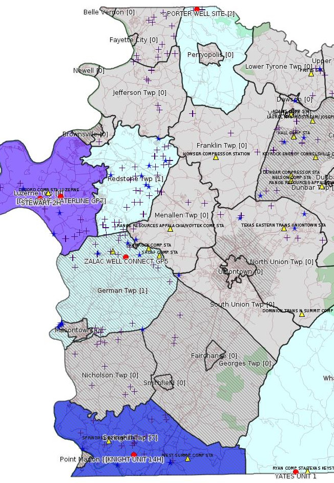
Click the map to enlarge
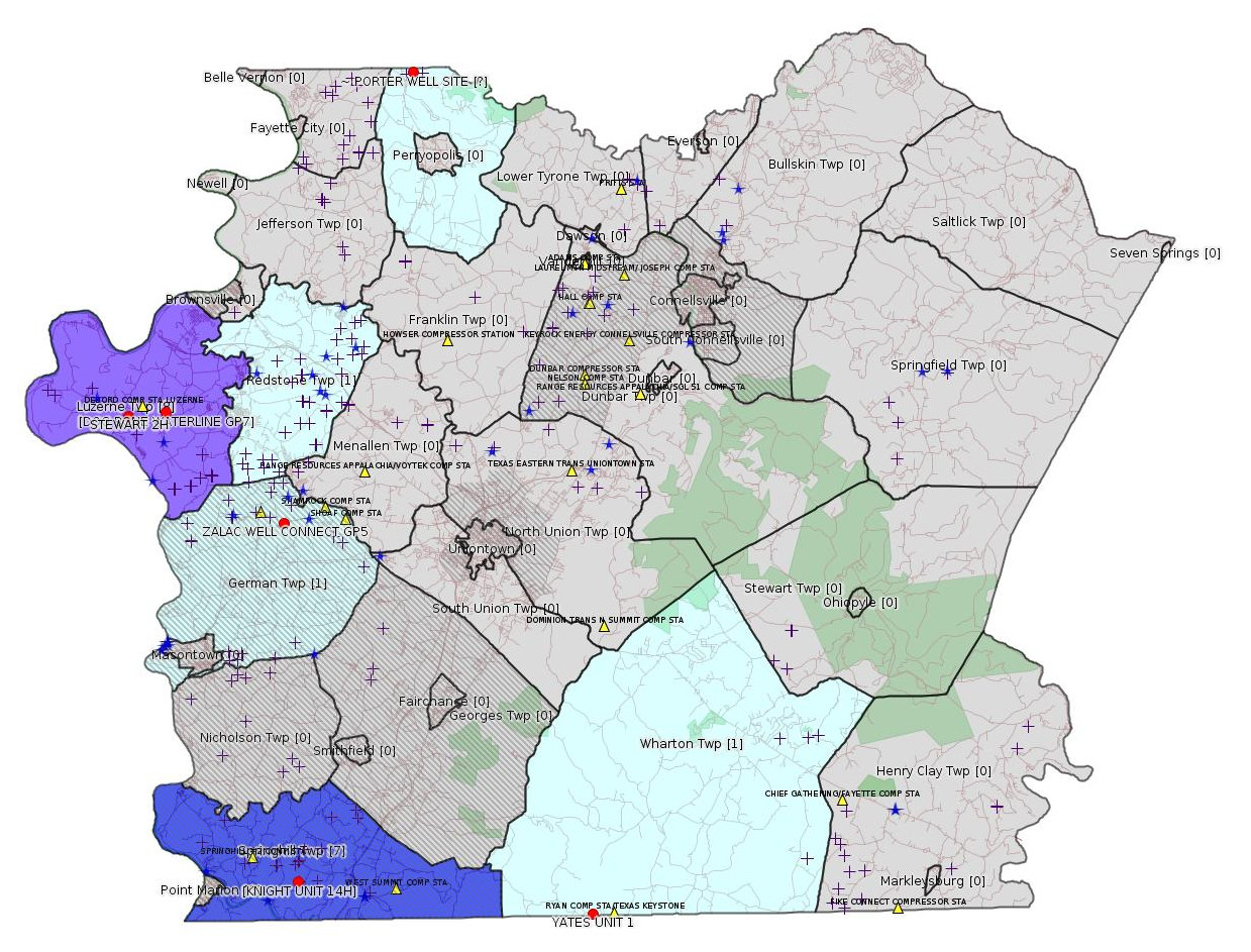
Map
Key
Red dots: items in this permit list with an exact location.
Orange triangles: Notifications in this permit list with an exact location.
Blue stars: Marcellus Gas Well Water Sources.
Municipality shading: number of "facilities", with each well counting separately
(includes the red dots):
Red dots: items in this permit list with an exact location.
Orange triangles: Notifications in this permit list with an exact location.
Blue stars: Marcellus Gas Well Water Sources.
Municipality shading: number of "facilities", with each well counting separately
(includes the red dots):
gray: 0
pale turquoise: 1
turquoise: 2
pale blue: 3
middle blue: 4
dark blue: 7
dark purple: 8
purple: 17
(Color coding may differ from one issue to the next.)
(Note if a project spans multiple municipalities -- e.g. a pipeline -- it will show in the count for each municipality.)
The number of facilities also follows the municipality name in brackets.
Municipality counts are based on the way the permit is listed by DEP; DEP has been known to get a municipality wrong.
Locations in brackets identify a precise location used to locate a surrogate for the actual site being permitted (e.g. locating a well pad or pipeline by the known location of a well.) Locations labeled beginning with "~" and ending in "[?]" are approximate and speculative based on inferences using on-line property and lease records. These are marked in the text as "[Approximate, Speculative]
eFACTS/eNOTICE applications of type Notification are not mapped.
Cross-hatching: Environmental Justice Areas
Yellow triangles: Compressor Stations
Crosses: Unconventional well permits (may not have been drilled)
Green: "Natural areas", e.g. state game lands, state forests
Yellow triangles: Compressor Stations
Crosses: Unconventional well permits (may not have been drilled)
Green: "Natural areas", e.g. state game lands, state forests
More Maps
 |
 |
Source: Pennsylvania Bulletin
ESCGP-2 No: ESX14-051-0016
Applicant Name: Chevron Appalachia LLC
Contact Person Alex Genovese
Address: 800 Mountain View Drive
City: Smithfield State: PA Zip Code: 15478
County: Fayette Township: Luzerne
Receiving Stream(s) and Classifications: UNTs to
Monongahela River, UNT to Rush Run/Middle
Monongahela River; Other WWF
<http://www.pabulletin.com/secure/data/vol45/45-29/1326d.html>
Site: STEWART WELL SITE ESCGP-2 EXPEDITED
Location [of STEWART 2H (surrogate)]: 39.962947,-79.946841 <http://osm.org/go/ZWpZPAOq--?m=>
-------------------------
Source: eNOTICE (+ PA Oil and Gas Mapping)
Authorization ID: 1075933
Permit number: ESX11-051-0030
Site: PORTER WELL SITE ESCGP-EXPEDITED
Client: CHEVRON APPALACHIA LLC
Authorization type: Expedited E&S Stormwater General Permit 1
Application type: Amendment
Authorization is for: SITE
Date received: 06/01/2015
Status: Withdrawn on 7/9/2015
<http://www.ahs.dep.pa.gov/eFACTSWeb/searchResults_singleAuth.aspx?AuthID=1075933>
Location [Approximate, Speculative]: 40.126115,-79.766563 <http://osm.org/go/ZWshKb9A--?m=>
Municipalities: Perry Twp, Rostraver Twp, Westmoreland County
Authorization ID: 1079834
Permit number: GP05260715006
Site: ZALAC WELL CONNECT GP5 & GP8
Client: LAUREL MTN MIDSTREAM OPR LLC
Authorization type: GP-05 Utility Line Stream Crossings
Application type: New
Authorization is for: FACILITY
Date received: 07/06/2015
Status: Pending
Sub-Facility ID Sub-Facility Name Description
1180403 ZALAC WELL CONNECT GP5 Pipeline or Conduit
<http://www.ahs.dep.pa.gov/eFACTSWeb/searchResults_singleAuth.aspx?AuthID=1079834>
Location: 39.910944,-79.850717 <http://osm.org/go/ZWpaL4lE--?m=>
Municipalities: German Twp [an Environmental Justice Area]
Authorization ID: 1079836
Permit number: GP08260715005
Site: ZALAC WELL CONNECT GP5 & GP8
Client: LAUREL MTN MIDSTREAM OPR LLC
Authorization type: GP-08 Temporary Road Crossings
Application type: New
Authorization is for: FACILITY
Date received: 07/06/2015
Status: Pending
Sub-Facility ID Sub-Facility Name Description
1180404 ZALAC WELL CONNECT GP8 Floodway Activity
<http://www.ahs.dep.pa.gov/eFACTSWeb/searchResults_singleAuth.aspx?AuthID=1079836>
Authorization ID: 1080933
Permit number: GP052615208
Site: COLUMBIA GAS OF PA FAYETTE CNTY
Client: COLUMBIA GAS OF PA INC
Authorization type: GP-05 Utility Line Stream Crossings
Application type: New
Authorization is for: FACILITY
Date received: 06/25/2015
Status: Pending
<http://www.ahs.dep.pa.gov/eFACTSWeb/searchResults_singleAuth.aspx?AuthID=1080933>
[No location information available.]
[Conventional Well:]
Authorization ID: 1078978
Permit number: 051-21949
Site: YATES UNIT 1 OG WELL
Client: RANGE RESOURCES APPALACHIA LLC
Authorization type: Well Plugging Notice Intent to Plug Single Well
Application type: New
Authorization is for: FACILITY
Date received: 06/18/2015
Status: Issued on 7/21/2015
Sub-Facility ID Sub-Facility Name Description
1059437 YATES UNIT 1 Well
<http://www.ahs.dep.pa.gov/eFACTSWeb/searchResults_singleAuth.aspx?AuthID=1078978>
Authorization ID: 1078991
Permit number: 051-21949
Site: YATES UNIT 1 OG WELL
Client: RANGE RESOURCES APPALACHIA LLC
Authorization type: Well Plugging Notice Alternate Method
Application type: New
Authorization is for: FACILITY
Date received: 06/18/2015
Status: Withdrawn on 7/16/2015
Sub-Facility ID Sub-Facility Name Description
784129 YATES UNIT 1 Well
<http://www.ahs.dep.pa.gov/eFACTSWeb/searchResults_singleAuth.aspx?AuthID=1078991>
Location: 39.721862,-79.662396 <http://osm.org/go/ZWo31rkU--?m=>
Municipalities: Wharton Twp
Authorization ID: 1077193
Permit number: 051-24628
Site: STEWART WELL SITE ESCGP-2 EXPEDITED
Client: CHEVRON APPALACHIA LLC
Authorization type: Drill & Operate Well Permit
Application type: New
Authorization is for: FACILITY
Date received: 06/04/2015
Status: Issued on 7/17/2015
Sub-Facility ID Sub-Facility Name Description
1171233 STEWART 2H Well
<http://www.ahs.dep.pa.gov/eFACTSWeb/searchResults_singleAuth.aspx?AuthID=1077193>
Location: 39.962947,-79.946841 <http://osm.org/go/ZWpZPAOq--?m=>
Municipalities: Luzerne Twp
Conservation Well: N
Full Permit:
<http://www.depgis.state.pa.us/PaOilAndGasMapping/PdFFetcher.ashx?Doc=wkQNC%2bx50KcZGJ%2fE8crb7A%3d%3d&ext=PDF>
Well Pad Emergency Response Plan:
<http://www.depgis.state.pa.us/PaOilAndGasMapping/eWellDocServiceFetcher.ashx?Doc=sHDan6cjN5XgGJrSvi7fZQ%3d%3d>
Authorization ID: 1077195
Permit number: 051-24629
Site: STEWART WELL SITE ESCGP-2 EXPEDITED
Client: CHEVRON APPALACHIA LLC
Authorization type: Drill & Operate Well Permit
Application type: New
Authorization is for: FACILITY
Date received: 06/04/2015
Status: Issued on 7/17/2015
Sub-Facility ID Sub-Facility Name Description
1171237 STEWART 3H Well
<http://www.ahs.dep.pa.gov/eFACTSWeb/searchResults_singleAuth.aspx?AuthID=1077195>
Conservation Well: N
Full Permit:
<http://www.depgis.state.pa.us/PaOilAndGasMapping/PdFFetcher.ashx?Doc=yxCWg7rgv7Wc98qsfjznTQ%3d%3d&ext=PDF>
Authorization ID: 1077198
Permit number: 051-24630
Site: STEWART WELL SITE ESCGP-2 EXPEDITED
Client: CHEVRON APPALACHIA LLC
Authorization type: Drill & Operate Well Permit
Application type: New
Authorization is for: FACILITY
Date received: 06/04/2015
Status: Issued on 7/17/2015
Sub-Facility ID Sub-Facility Name Description
1171239 STEWART 4H Well
<http://www.ahs.dep.pa.gov/eFACTSWeb/searchResults_singleAuth.aspx?AuthID=1077198>
Conservation Well: N
Full Permit:
<http://www.depgis.state.pa.us/PaOilAndGasMapping/PdFFetcher.ashx?Doc=EuBJH6OQeT0zmvJYwrp74A%3d%3d&ext=PDF>
Authorization ID: 1077201
Permit number: 051-24631
Site: STEWART WELL SITE ESCGP-2 EXPEDITED
Client: CHEVRON APPALACHIA LLC
Authorization type: Drill & Operate Well Permit
Application type: New
Authorization is for: FACILITY
Date received: 06/04/2015
Status: Issued on 7/17/2015
Sub-Facility ID Sub-Facility Name Description
1171242 STEWART 5H Well
<http://www.ahs.dep.pa.gov/eFACTSWeb/searchResults_singleAuth.aspx?AuthID=1077201>
Conservation Well: N
Full Permit:
<http://www.depgis.state.pa.us/PaOilAndGasMapping/PdFFetcher.ashx?Doc=%2bYpE000cTL%2bwH6eS1D%2bXtw%3d%3d&ext=PDF>
Authorization ID: 1077205
Permit number: 051-24632
Site: STEWART WELL SITE ESCGP-2 EXPEDITED
Client: CHEVRON APPALACHIA LLC
Authorization type: Drill & Operate Well Permit
Application type: New
Authorization is for: FACILITY
Date received: 06/04/2015
Status: Issued on 7/17/2015
Sub-Facility ID Sub-Facility Name Description
1171243 STEWART 6H Well
<http://www.ahs.dep.pa.gov/eFACTSWeb/searchResults_singleAuth.aspx?AuthID=1077205>
Conservation Well: N
Full Permit:
<http://www.depgis.state.pa.us/PaOilAndGasMapping/PdFFetcher.ashx?Doc=mDtjHBmG9q71gWsOMJXXFg%3d%3d&ext=PDF>
Authorization ID: 1081589
Permit number: ESX12-051-0011
Site: DUNLAP CREEK PIPELINE ESCGP-EXPEDITED
Client: LAUREL MTN MIDSTREAM OPR LLC
Authorization type: Expedited E&S Stormwater General Permit 1
Application type: Notification
Authorization is for: SITE
Date received: 07/17/2015
Status: Pending
<http://www.ahs.dep.pa.gov/eFACTSWeb/searchResults_singleAuth.aspx?AuthID=1081589>
Municipalities: Luzerne Twp, Redstone Twp
Authorization ID: 1070758
Permit number: 051-24537
Site: KNIGHT UNIT WELL ESCGP-EXPEDITED
Client: CHEVRON APPALACHIA LLC
Authorization type: Alternate Waste Management Practice
Application type: New
Authorization is for: FACILITY
Date received: 04/03/2015
Status: Issued on 7/21/2015
Sub-Facility ID Sub-Facility Name Description
1087658 KNIGHT UNIT 14H Well
1087656 KNIGHT UNIT 15H Well
1087655 KNIGHT UNIT 16H Well
1127596 KNIGHT UNIT 17H Well
1087653 KNIGHT UNIT 17H Well
1087654 KNIGHT UNIT 17H Well
1087652 KNIGHT UNIT 18H Well
1087651 KNIGHT UNIT 19H Well
1087649 KNIGHT UNIT 20H Well
<http://www.ahs.dep.pa.gov/eFACTSWeb/searchResults_singleAuth.aspx?AuthID=1070758>
Location [of KNIGHT UNIT 14H (surrogate)]: 39.738977,-79.844827 <http://osm.org/go/ZWpKkMoT--?m=>
Municipalities: Springhill Twp [an Environmental Justice Area]
Authorization ID: 1071252
Permit number: ESX15-051-0009
Site: DOG BONE WATERLINE ESCGP-2 EXPEDITED
Client: CHEVRON APPALACHIA LLC
Authorization type: Expedited E&S Stormwater General Permit 1
Application type: New
Authorization is for: SITE
Date received: 04/29/2015
Status: Pending
<http://www.ahs.dep.pa.gov/eFACTSWeb/searchResults_singleAuth.aspx?AuthID=1071252>
Location [of DOG BONE WATERLINE GP7]: 39.964714,-79.923661 <http://osm.org/go/ZWpZnGdB--?m=>
Municipalities: Luzerne Twp
-------------------------
Source: Reuters Commodities: Energy
Natural Gas
| Commodity | Exchange | Currency | Expire | Last Trade | Trade Time | Change | Open | Day's High | Day's Low |
|---|---|---|---|---|---|---|---|---|---|
| NATURAL
GAS CON1 Jul15 |
NYM | USD | 07/29 | 2.76 | 07/27 01:13 | -0.02 | 2.74 | 2.76 | 2.73 |
-------------------------
Notes:
[None]
------------------------
DEP defines an environmental justice area as "any census tract where 20 percent or more individuals live in poverty, and/or 30 percent or more of the population is minority". (See:
<http://www.portal.state.pa.us/portal/server.pt/community/pa_environmental_justice_areas/20991>
<http://www.portal.state.pa.us/portal/server.pt/community/dep_enhanced_public_participation_policy/20988>
). There are supposed to be enhanced public participation requirements for permits in environmental justice areas, but news of this actually ever happening is scarce. In Fayette County, the entirety of Springhill, Nicholson, German, and Georges Townships are environmental justice areas, as well as a large part of Dunbar Township. DEP's policy document on public participation guidelines for environmental justice areas is located here:
<http://www.elibrary.dep.state.pa.us/dsweb/Get/Version-48671/012-0501-002.pdf>
eNOTICE records are likely to list the same permit multiple times, as that permit moves through the DEP process.
Oil & Gas Wells designated with a site a number and the letter H typically designate horizontal wells.
The eMapPa web site does not work in web browsers other than Internet Explorer. For instructions on how to view eMapPa data in Firefox send me E-mail.
-------------------------
Resources:
Pennsylvania Bulletin: <http://www.pabulletin.com/>
eNOTICE: <http://www.ahs2.dep.state.pa.
DEP Well Details Report: <https://www.paoilandgasreport
Well Details may not show any
information for new permits and will not show permits which have
not yet been issued. Lookup for Well Details is by permit number.
DEP Permits Issued Detail Report:
<http://www.depreportingservic
DEP SPUD (drilling started) Report:
<http://www.depreportingservices.state.pa.us/ReportServer/Pages/ReportViewer.aspx?/Oil_Gas/Spud_External_Data>
DEP Oil and Gas Compliance Report:
<http://www.depreportingservices.state.pa.us/ReportServer/Pages/ReportViewer.aspx?/Oil_Gas/OG_Compliance>
DEP PA Oil & Gas Mapping:
<http://www.depgis.state.pa.us/PaOilAndGasMapping>
Pennsylvania Spatial Data Access:
<http://www.pasda.psu.edu/default.asp>
DEP Spatial Data Repository:
<ftp://www.pasda.psu.edu/pub/pasda/dep/>
National Response Center:
<http://www.nrc.uscg.mil/>
EPA-Echo: <http://www.epa-echo.gov/echo/
FERC citizen involvement: <http://www.ferc.gov/for-citiz
To receive E-mail notification of
all documents filed in a FERC docket, see:
<http://www.ferc.gov/docs-filing/esubscription.asp >
<http://www.ferc.gov/docs-fili
Follow the directions and enter the docket number to subscribe to.
Township Supervisors receive information regarding Erosion & Sedimentation permits, and these records may be reviewable at township municipal offices.
DEP permits are reviewable through the File Review process, for application to do file review see: <http://www.portal.state.pa.us/portal/server.pt/community/southwest_regional_office/13775/file_review/593164>
Environmental Hearing Board: <http://ehb.courtapps.com/publ
PA DEP Environmental Policy Comment System:
<http://www.ahs.dep.pa.gov/eComment/>
Federal Register Environment: <https://www.federalregister.g
Browsing of recent comment
opportunities for federal agencies, e.g. EPA. Click "sign up" to
subscribe to daily E-mails of new document listings.
SkyTruth Fayette County Drilling Alerts: <http://frack.skytruth.org/pen
EPA Region 3 Water Protection Public Notices: <http://www.epa.gov/reg3wapd/p
Marcellus Shale waste disposal
injection wells in Pennsylvania are regulated directly by EPA, not
DEP. Notice of any new permit applications will appear at the
above web address. I'm not aware of any subscription service
to be notified of such applications. I'm not aware of any
Marcellus Shale waste disposal injection wells in Fayette County
(yet ...) but we need to monitor this page for future
applications.
Energy Assurance Daily: <http://www.oe.netl.doe.gov/ead.aspx>
Daily newsletter from the US
Department of Energy about events relating to energy. The Natural
Gas section has information about pipelines.
-------------------------
Disclaimers:
This compilation from the above sources was done by hand using copy and paste and may omit relevant permits.
Does not currently include water supply permits. Does not include landfill permits even though many such are for Marcellus Shale waste. (It is not possible at this time to distinguish which landfill permits are for Marcellus Shale waste and which are not without doing File Review for each permit.)
Erosion & Sedimentation permit records do not currently include latitude and longitude. Where I am publishing latitude and longitude with E&S permits it is by inferring an associated well permit and using published latitude and longitude for the well. It is possible I may be inferring the wrong well site.
Municipalities are shown from eFACTS records on the DEP web site. The DEP has been known to list a municipality incorrectly.