The Harmed Success Stories Concepts How To What Is Commentary
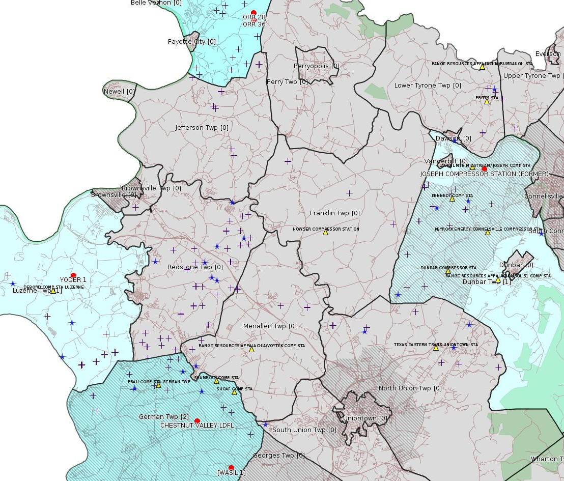
Fayette County Marcellus Shale Permits 10/31/16 - 11/13/16
Click the map to enlarge

Map
Key
Red dots: items in this permit list with an exact location.
Blue stars: Marcellus Gas Well Water Sources.
Municipality shading: number of "facilities", with each well counting separately
(includes the red dots):
Red dots: items in this permit list with an exact location.
Blue stars: Marcellus Gas Well Water Sources.
Municipality shading: number of "facilities", with each well counting separately
(includes the red dots):
gray: 0
pale turquoise: 1
turquoise: 2
pale blue: 3
middle blue: 4
dark blue: 6
dark purple: 9
purple: 19
(Color coding may differ from one issue to the next.)
(Note if a project spans multiple municipalities -- e.g. a pipeline -- it will show in the count for each municipality.)
The number of facilities also follows the municipality name in brackets.
Municipality counts are based on the way the permit is listed by DEP; DEP has been known to get a municipality wrong.
Locations in brackets identify a precise location used to locate a surrogate for the actual site being permitted (e.g. locating a well pad or pipeline by the known location of a well.) Locations labeled beginning with "~" and ending in "[?]" are approximate and speculative based on inferences using on-line property and lease records. These are marked in the text as "[Approximate, Speculative]
Cross-hatching: Environmental Justice Areas
Yellow triangles: Compressor Stations
Crosses: Unconventional well permits (may not have been drilled)
Green: "Natural areas", e.g. state game lands, state forests
Yellow triangles: Compressor Stations
Crosses: Unconventional well permits (may not have been drilled)
Green: "Natural areas", e.g. state game lands, state forests
More Maps
 |
 |
 |
| Zoomed map 10/31/16 - 11/13/16 |
Oriskany Sandstone Map |
Oriskany Sandstone
Stratigraphic Chart |
Source: Pennsylvania Bulletin
[No Activity]
-------------------------
Source: eNOTICE (+ PA Oil and Gas Mapping, Well Pad Report) Please see the Disclaimer below regarding Parcel Id data.
[Conventional Well:]
Authorization ID: 1157950
Permit number: ESX11-051-0025
Site: WASIL 1 WELL PAD ESCGP-EXPEDITED
Client: BURNETT OIL CO INC
Authorization type: Expedited E&S Stormwater General Permit 1
Application type: Notification
Authorization is for: SITE
Date received: 07/18/2016
Status: Issued on 11/2/2016
<http://www.ahs.dep.pa.gov/eFACTSWeb/searchResults_singleAuth.aspx?AuthID=1157950>
Location [of WASIL 1]: 39.871472,-79.815522 <http://osm.org/go/ZWpPuFAu--?m=>
Municipalities: German Twp [an Environmental Justice Area]
Presumed Parcel Id: 1536004304
Well Details Report Record [for WASIL 1]:
<https://www.paoilandgasreporting.state.pa.us/publicreports/Modules/WellDetails/WellDetails.aspx?PermitNumber=051-24448>
Authorization ID: 1098628
Permit number: 100419
Site: CHESTNUT VALLEY LDFL
Client: ADVANCED DSPL SVC CHESTNUT VALLEY LDFL INC
Authorization type: Minor Modification to an Existing Fac
Application type: Modification
Authorization is for: FACILITY
Date received: 11/23/2015
Status: Pending
Sub-Facility ID Sub-Facility Name Description
212043 J&J LANDFILL Landfill
<http://www.ahs.dep.pa.gov/eFACTSWeb/searchResults_singleAuth.aspx?AuthID=1098628>
Location: 39.896765,-79.838766 <http://osm.org/go/ZWpP0~XK--?m=>
Municipalities: German Twp [an Environmental Justice Area]
Presumed Parcel Id: 15280012
A Notice of Intent to Remediate (NIR) has been submitted to the Department for the following facilities. The submission of an NIR demonstrates an intention by a private party to implement a remedial response action at a contaminated site under the terms of the Land Recycling Act.
--
Fayette:
Facility # 813543 located in Dunbar - NIR date received 10/17/2016.
--
Land Recycling Information Details
Activity ID: 49865
--
Response Action Name: Risk Assess Report Required?: Cleanup Standard: Cleanup Plan Required?:
N Statewide Health Standard N
No records matched the criteria.
--
Buyer/Seller Agreement: Cleanup Costs: Remarks:
None None None
There were not any Cleanup Indicators found.
There were not any Remarks found.
--
Milestones: Event Date: Decision Date: Decision:
SWH Date NIR published in newspaper 09/22/2016
SWH Date DEP acknowledged receipt of NIR 10/17/2016
SWH Date NIR submitted (Statewide Health) 10/17/2016
SWH Date of proof of submittal of the NIR to municipality 10/17/2016
SWH Date of submittal of NIR newspaper notice proof 10/17/2016
Oil & Gas Remedial Action Completion Report Submitted
Oil & Gas Remedial Action Plan Submitted
Oil & Gas Site Characterization Report Submitted
SWH Date final report published in newspaper
SWH Date DEP acknowledged receipt of final report
SWH Date DEP received proof of final report submit to muni.
SWH Date NIR published in Pa Bulletin
SWH Date final report action published in Pa Bulletin
SWH Date final report submission published in Pa Bulletin
SWH Date final report submitted
SWH Date final report submitted within 90 days of release
SWH Date proof of final report newspaper pub. submitted
--
Media Type Information
Sub Facility ID: Media Type Name: Media Type: Latitude: Longitude:
1221143 JOSEPH COMPRESSOR STATION (FORMER) SOIL
--
There were not any Chemicals found.
<http://www.ahs.dep.pa.gov/eFACTSWeb/searchResults_singleLandDetInfo.aspx?ActivityID=49865>
Land Recycling Information Search Details
Property Size: Site Size: Jobs Saved/Created: Multi-Site Agreement Date: Non-Use Aquifer Date: Areawide Background Date: Land Designation Desc:
None
--
General Information
NIR Type NIR Received Date Preparer of NIR
NIR 10/17/2016
--
Land Recycling Information Search Activity Details
Response Action Name: Cleanup Standard: Residential/Non-Residential: Risk Assessment Report Required?: Cleanup Plan Required?:
(49865) Statewide Health Standard No No
<http://www.ahs.dep.pa.gov/eFACTSWeb/searchResults_singleLandInfo.aspx?LRPFACDETID=67195>
Location: 40.029921,-79.635939 [an Environmental Justice Area] <http://osm.org/go/ZWp2~J_F--?m=>
Presumed Parcel Id: 09050236
Municipalities: Dunbar Twp
[See Notes.]
Authorization ID: 1158921
Permit number: 051-24635
Site: YODER WELL PAD ESCGP-2 EXPEDITED
Client: CHEVRON APPALACHIA LLC
Authorization type: Drill & Operate Well Permit
Application type: Renewal
Authorization is for: FACILITY
Date received: 09/23/2016
Status: Pending
<http://www.ahs.dep.pa.gov/eFACTSWeb/searchResults_singleAuth.aspx?AuthID=1158921>
Sub-Facility ID Sub-Facility Name Description eMap PA Location
1186051 YODER 1 Well
Conservation Well: N
Well Configuration: Vertical Well
Coal: Coal
Anticipated Maximum TVD: 8005 feet
Location: 39.975683,-79.923763 <http://osm.org/go/ZWpZzGbq--?m=>
Municipalities: Luzerne Twp
Parcel Id: 19160034
Original Full Permit:
<http://www.depgis.state.pa.us/pdfHandler/pdFHandler.ashx?Doc=MjE4NzEx&ext=PDF>
-------------------------
Source: DEP Oil and Gas Electronic Notifications
NOTIFICATION_ID: 31813
OGO: 40027
OPERATOR: TAFT OPERATING LLC
API_PERMIT: 051-23940
SPUD_DATE: 06/11/2008
COUNTY: Fayette
MUNICIPALITY: Washington
LATITUDE: 40.111696
LONGITUDE: -79.795435
SUBJECT: [NOTIFICATION]: Stimulation notification 58 Pa. C.S. 3211(f)(2) for well API 37-051-23940-00-00
QUESTION: Date and approximate time action is to occur
ANSWER: Date: 11/14/2016 Time: 12:00 PM
SENT_DATE: 11/10/2016 6:42:55 AM
SENT_SUCCESS: Yes
LAST_RESENT_DATE:
RESENT_SUCCESS:
Comments: Taft Operating, LLC intends to stimulate the Oriskany Sandstone on November 14th, 2016 at approximately 12:00 PM EST.
Farm Name: ORR 36
Location: 40.111696,-79.795435 <http://osm.org/go/ZWsgUo3r--?m=>
Presumed Parcel Id: 41190001
Well Details Report Record:
<https://www.paoilandgasreporting.state.pa.us/publicreports/Modules/WellDetails/WellDetails.aspx?PermitNumber=051-23940>
[See Notes.]
NOTIFICATION_ID: 31698
OGO: 40027
OPERATOR: TAFT OPERATING LLC
API_PERMIT: 051-23452
SPUD_DATE: 11/13/2006
COUNTY: Fayette
MUNICIPALITY: Washington
LATITUDE: 40.115393
LONGITUDE: -79.795546
SUBJECT: [NOTIFICATION]: Stimulation notification 58 Pa. C.S. 3211(f)(2) for well API 37-051-23452-00-00
QUESTION: Date and approximate time action is to occur
ANSWER: Date: 11/14/2016 Time: 07:00 PM
SENT_DATE: 11/3/2016 9:19:27 AM
SENT_SUCCESS: Yes
LAST_RESENT_DATE:
RESENT_SUCCESS:
Comments: Taft Operating, LLC intends to stimulate the Oriskany Sandstone on November 14th, 2016 at approximately 7:00 PM EST.
Farm Name: ORR 28
Location: 40.115393,-79.795546 <http://osm.org/go/ZWsgU8mN--?m=>
Presumed Parcel Id: 41190001
Well Details Report Record:
<https://www.paoilandgasreporting.state.pa.us/publicreports/Modules/WellDetails/WellDetails.aspx?PermitNumber=051-23452>
-------------------------
Source: Reuters Commodities: Energy
Natural Gas
| Commodity | Exchange | Currency | Expire | Last Trade | Trade Time | Change | Open | Day's High | Day's Low |
|---|---|---|---|---|---|---|---|---|---|
| NATURAL
GAS CON1 Nov16 |
NYM | USD | 11/28 | 2.75 | 11/13 19:25 | -0.00 | 2.75 | 2.75 | 2.73 |
-------------------------
Notes:
Remediation of the former Joseph Compressor Station was listed in the 10/16/16 issue of this bulletin based on a legal notice in the Uniontown Herald Standard. That notice stated that "the site had been found to be contaminated with triethylene glycol." However the records above are showing "There were not any Chemicals found." At this time there is no explanation for this discrepancy. It is not clear whether there will be any public comment opportunities regarding this issue. As noted in the 10/16/16 issue:
Triethylene glycol is the chemical used in most dehydrators to remove water from the gas stream. If it has contaminated the soil, then obviously it was leaking; it would be surprising if such a leak did not also release significant amounts of air pollution. Laurel Mountain Midstream's own self-reported Marcellus Shale Air Emissions Inventory figures for 2012-2014 show over 3 tons of formaldehyde in each year, which considering it is an extremely small compressor station seems excessive.
---
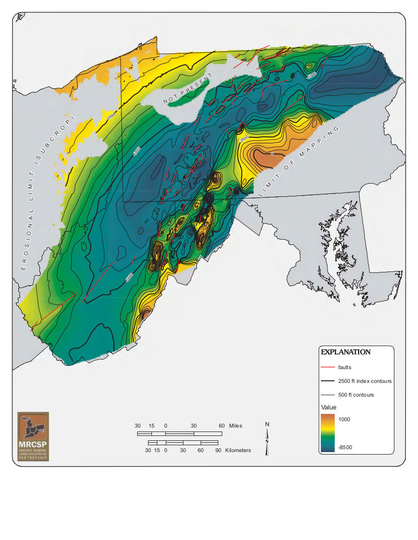
The Oriskany Sandstone is just below the Onondaga Limestone, meaning that the ORR wells referred to above under Electronic Notifications are covered under the Oil & Gas Conservation Law. The OGC Law includes a Forced Pooling Provision, but apparently it has never been invoked. The details are complicated, but to invoke Forced Pooling, an operator must first obtain a Well Spacing Order, and then obtain an Integration Order. For a web page explaining Forced Pooling see: <http://faymarwatch.org/whatis/Forced_Pooling.shtml>
For a map and stratigraphic chart showing the Oriskany Sandstone, see the "More Maps" section at the beginning of this bulletin. Map source:
<http://www.dcnr.state.pa.us/cs/groups/public/documents/document/dcnr_016123.pdf>
Chart source:
<http://www.dcnr.state.pa.us/cs/groups/public/documents/document/dcnr_016125.pdf>
"Stimulation" with respect to the ORR wells above is apparently the "classical" kind of Oil & Gas stimulation to boost production toward the end of a well's lifetime, as opposed to Marcellus or Utica fracking where without "stimulation" at the beginning of a well's lifetime, there will be no gas produced at all. When the Oil & Gas industry claims that "fracking has been going on for 60 years", they are referring to the older, extend end of life type of stimulation. Evidently DEP uses the same type of electronic notification message for both. Whether it will be economical to "refrack" shale gas wells is not yet clear; fracking tends to be extremely expensive.
The ORR wells mentioned above were originally drilled by Atlas.
------------------------
DEP defines an environmental justice area as "any census tract where 20 percent or more individuals live in poverty, and/or 30 percent or more of the population is minority". (See:
<http://www.portal.state.pa.us/portal/server.pt/community/pa_environmental_justice_areas/20991>
<http://www.portal.state.pa.us/portal/server.pt/community/dep_enhanced_public_participation_policy/20988>
). There are supposed to be enhanced public participation requirements for permits in environmental justice areas, but news of this actually ever happening is scarce. In Fayette County, the entirety of Springhill, Nicholson, German, and Georges Townships are environmental justice areas, as well as a large part of Dunbar Township. DEP's policy document on public participation guidelines for environmental justice areas is located here:
<http://www.elibrary.dep.state.pa.us/dsweb/Get/Version-48671/012-0501-002.pdf>
eNOTICE records are likely to list the same permit multiple times, as that permit moves through the DEP process.
Oil & Gas Wells designated with a site a number and the letter H typically designate horizontal wells.
-------------------------
Resources:
Pennsylvania Bulletin: <http://www.pabulletin.com/>
eNOTICE: <http://www.ahs2.dep.state.pa.
DEP Well Details Report: <https://www.paoilandgasreport
Well Details may not show any
information for new permits and will not show permits which have
not yet been issued. Lookup for Well Details is by permit number.
DEP Permits Issued Detail Report:
<http://www.depreportingservic
DEP SPUD (drilling started) Report:
<http://www.depreportingservices.state.pa.us/ReportServer/Pages/ReportViewer.aspx?/Oil_Gas/Spud_External_Data>
DEP Oil and Gas Compliance Report:
<http://www.depreportingservices.state.pa.us/ReportServer/Pages/ReportViewer.aspx?/Oil_Gas/OG_Compliance>
DEP PA Oil & Gas Mapping:
<http://www.depgis.state.pa.us/PaOilAndGasMapping>
DEP Oil and Gas Electronic Notifications
<http://www.depreportingservices.state.pa.us/ReportServer?/Oil_Gas/OG_Notifications>
DEP Oil and Gas Well Pad Report
<http://www.depreportingservices.state.pa.us/ReportServer?/Oil_Gas/Well_Pads>
Fayette County Assessment Office Search For Tax Records:
<http://property.co.fayette.pa.us/search.aspx>
Pennsylvania Spatial Data Access:
<http://www.pasda.psu.edu/default.asp>
DEP Spatial Data Repository:
<ftp://www.pasda.psu.edu/pub/pasda/dep/>
National Response Center:
<http://www.nrc.uscg.mil/>
EPA-Echo: <http://www.epa-echo.gov/echo/
FERC citizen involvement: <http://www.ferc.gov/for-citiz
To receive E-mail notification of
all documents filed in a FERC docket, see:
<http://www.ferc.gov/docs-filing/esubscription.asp >
<http://www.ferc.gov/docs-fili
Follow the directions and enter the docket number to subscribe to.
Township Supervisors receive information regarding Erosion & Sedimentation permits, and these records may be reviewable at township municipal offices.
DEP permits are reviewable through the File Review process, for application to do file review see: <http://www.portal.state.pa.us/portal/server.pt/community/southwest_regional_office/13775/file_review/593164>
Environmental Hearing Board: <http://ehb.courtapps.com/publ
PA DEP Environmental Policy Comment System:
<http://www.ahs.dep.pa.gov/eComment/>
Federal Register Environment: <https://www.federalregister.g
Browsing of recent comment
opportunities for federal agencies, e.g. EPA. Click "sign up" to
subscribe to daily E-mails of new document listings.
SkyTruth Fayette County Drilling Alerts: <http://frack.skytruth.org/pen
New: U.S. Army Corps of Engineers, Pittsburgh District, Public Notices:
<http://www.lrp.usace.army.mil/Missions/Regulatory/Public-Notices/>
EPA Pennsylvania Public Notices: <http://www2.epa.gov/aboutepa/epa-pennsylvania#notice>
Marcellus Shale waste disposal
injection wells in Pennsylvania are regulated directly by EPA, not
DEP. Notice of any new permit applications will appear at the
above web address. I'm not aware of any subscription service
to be notified of such applications. I'm not aware of any
Marcellus Shale waste disposal injection wells in Fayette County
(yet ...) but we need to monitor this page for future
applications.
Energy Assurance Daily: <http://www.oe.netl.doe.gov/ead.aspx>
Daily newsletter from the US
Department of Energy about events relating to energy. The Natural
Gas section has information about pipelines.
-------------------------
Disclaimers:
This compilation from the above sources was done by hand using copy and paste and may omit relevant permits.
Parcel data is provided via the tax records search web page offered by the Fayette County Assessment Office (http://property.co.fayette.pa.us/). Presumed Parcel Id links are subject to availability provided by that agency and associated web sites. Presumed Parcel Ids are determined as the mapped parcel containing a given latitude and longitude, are a best effort determination which is subject to error, and are not official. In cases where a facility is leased and there is a separate parcel id for the lease, if this parcel id is not separately mapped, the parcel id shown will be the id for the enclosing parcel. Parcel owners may be surface owners only and may or may not have any relationship to oil & gas facilities.
Does not currently include water supply permits. Does not include landfill permits even though many such are for Marcellus Shale waste. (It is not possible at this time to distinguish which landfill permits are for Marcellus Shale waste and which are not without doing File Review for each permit.)
Erosion & Sedimentation permit records do not currently include latitude and longitude. Where I am publishing latitude and longitude with E&S permits it is by inferring an associated well permit and using published latitude and longitude for the well. It is possible I may be inferring the wrong well site.
Municipalities are shown from eFACTS records on the DEP web site. The DEP has been known to list a municipality incorrectly.