The Harmed Success Stories Concepts How To What Is Commentary
Fayette County Marcellus Shale Permits 11/28/16 - 12/11/16
Click the map to enlarge
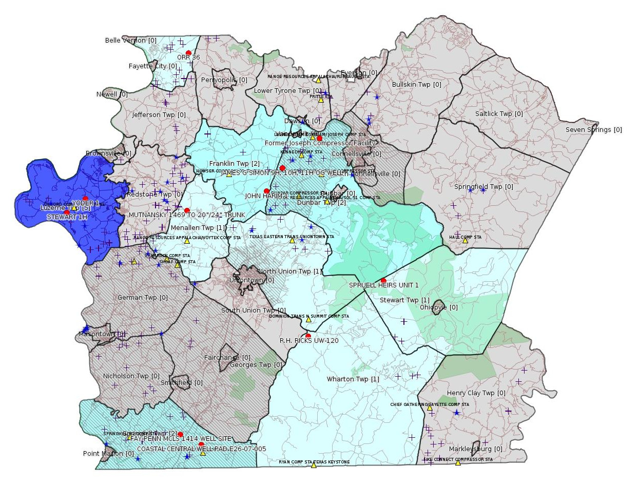
Map
Key
Red dots: items in this permit list with an exact location.
Blue stars: Marcellus Gas Well Water Sources.
Municipality shading: number of "facilities", with each well counting separately
(includes the red dots):
Red dots: items in this permit list with an exact location.
Blue stars: Marcellus Gas Well Water Sources.
Municipality shading: number of "facilities", with each well counting separately
(includes the red dots):
gray: 0
pale turquoise: 1
turquoise: 2
pale blue: 3
middle blue: 4
dark blue: 6
dark purple: 9
purple: 19
(Color coding may differ from one issue to the next.)
(Note if a project spans multiple municipalities -- e.g. a pipeline -- it will show in the count for each municipality.)
The number of facilities also follows the municipality name in brackets.
Municipality counts are based on the way the permit is listed by DEP; DEP has been known to get a municipality wrong.
Locations in brackets identify a precise location used to locate a surrogate for the actual site being permitted (e.g. locating a well pad or pipeline by the known location of a well.) Locations labeled beginning with "~" and ending in "[?]" are approximate and speculative based on inferences using on-line property and lease records. These are marked in the text as "[Approximate, Speculative]
Cross-hatching: Environmental Justice Areas
Yellow triangles: Compressor Stations
Crosses: Unconventional well permits (may not have been drilled)
Green: "Natural areas", e.g. state game lands, state forests
Yellow triangles: Compressor Stations
Crosses: Unconventional well permits (may not have been drilled)
Green: "Natural areas", e.g. state game lands, state forests
More Maps
 |
Source: Pennsylvania Bulletin
Williams Northeast Gathering & Processing Laurel Mountain Midstream Former Joseph Compressor Facility, 420 Vanderbilt Road, Dunbar Township, Fayette County. Moody and Associates, Inc., 11548 Cotton Road, Meadville, PA 16335 on behalf of Williams Northeast Gathering & Processing Laurel Mountain Midstream, 111 Enterprise Lane, Connellsville, PA 15425 has submitted a Notice of Intent to Remediate (NIR) to meet the residential Statewide Health standards concerning site soils contaminated with triethylene glycol from a release. Notice of the NIR was published in the Herald-Standard on September 22, 2016.
<http://www.pabulletin.com/secure/data/vol46/46-49/2078a.html>
Location: 40.029921,-79.635939 [an Environmental Justice Area] <http://osm.org/go/ZWp2~J_F--?m=>
Presumed Parcel Id: 09050236
Municipalities: Dunbar Twp
-------------------------
Source: eNOTICE (+ PA Oil and Gas Mapping, Well Pad Report) Please see the Disclaimer below regarding Parcel Id data.
Authorization ID: 1156762
Permit number: ESX13-051-0003
Site: FAY-PENN MCLS 1414 WELL SITE ESCGP2 - EXPEDITED
Client: CHEVRON APPALACHIA LLC
Authorization type: Expedited E&S Stormwater General Permit 1
Application type: Notification
Authorization is for: SITE
Date received: 06/30/2016
Status: Issued on 11/23/2016
<http://www.ahs.dep.pa.gov/eFACTSWeb/searchResults_singleAuth.aspx?AuthID=1156762>
Location: 39.752572,-79.811431 <http://osm.org/go/ZWpK6bVi--?m=>
Municipalities: Springhill Twp [an Environmental Justice Area]
Presumed Parcel Id: 36080081
Well Pad ID: 149746
Wells on this pad:
051-24583 FAY-PENN UNIT 46H
051-24584 FAY-PENN UNIT 47H
051-24585 FAY-PENN UNIT 48H
[Conventional Well]:
Authorization ID: 1160605
Permit number: 051-20056
Site: RH RICKS UW-120 WELL
Client: DOMINION TRANS INC
Authorization type: Well Plugging Notice Intent to Plug Single Well
Application type: New
Authorization is for: FACILITY
Date received: 07/18/2016
Status: Pending
Sub-Facility ID Sub-Facility Name Description
56263 R.H. RICKS UW-120 Well
<http://www.ahs.dep.pa.gov/eFACTSWeb/searchResults_singleAuth.aspx?AuthID=1160605>
Location: 39.843591,-79.653423 <http://osm.org/go/ZWpmzsHH--?m=>
Municipalities: Wharton Twp
Presumed Parcel Id: 4205009701
<https://www.paoilandgasreporting.state.pa.us/publicreports/Modules/WellDetails/WellDetails.aspx?PermitNumber=051-20056>
[See Notes.]
Authorization ID: 1160749
Permit number: ESX14-051-0005
Site: JAMES G SIMON 9H, 10H, 11H OG WELL ESCGP-2 EXPEDITED
Client: XTO ENERGY INC
Authorization type: Expedited E&S Stormwater General Permit 1
Application type: Notification
Authorization is for: SITE
Date received: 10/12/2016
Status: Pending
<http://www.ahs.dep.pa.gov/eFACTSWeb/searchResults_singleAuth.aspx?AuthID=1160749>
Location: 40.002533,-79.682167 <http://osm.org/go/ZWp2ODXm--?m=> [an Environmental Justice Area]
Municipalities: Dunbar Twp
Presumed Parcel Id: 09100040
Well Pad Id: 149686
Wells on this pad:
051-24334 JAMES G SIMON ETUX 11H
051-24335 JAMES G SIMON ETAL 9H
051-24336 JAMES G SIMON ETAL 10H
[Conventional Well:]
Authorization ID: 1160218
Permit number: 051-20870
Site: JOHN HARIM 1 Well
Client: AMER EXPLORATION CO
Authorization type: Well Plugging Notice Intent to Plug Single Well
Application type: New
Authorization is for: FACILITY
Date received: 11/21/2016
Status: Pending
Sub-Facility ID Sub-Facility Name Description
366280 JOHN HARIM 1 Well
<http://www.ahs.dep.pa.gov/eFACTSWeb/searchResults_singleAuth.aspx?AuthID=1160218>
Location: 39.980946,-79.701941 <http://osm.org/go/ZWpzWMt0--?m=>
Municipalities: Franklin Twp
Presumed Parcel Id: 13180021
Well Details Report Record:
<https://www.paoilandgasreporting.state.pa.us/publicreports/Modules/WellDetails/WellDetails.aspx?PermitNumber=051-20870>
[Conventional Well:]
Authorization ID: 1159679
Permit number: 051-21149
Site: SPRUELL HEIRS UNIT 1 OG WELL
Client: XTO ENERGY INC
Authorization type: Well Plugging Notice Intent to Plug Single Well
Application type: New
Authorization is for: FACILITY
Date received: 09/06/2016
Status: Pending
<http://www.ahs.dep.pa.gov/eFACTSWeb/searchResults_singleAuth.aspx?AuthID=1159679>
Location: 39.894609,-79.560586 <http://osm.org/go/ZWpt8Sz~--?m=>
Municipality: Stewart Twp
Presumed Parcel Id: 14240076
Well Details Report Record:
<https://www.paoilandgasreporting.state.pa.us/publicreports/Modules/WellDetails/WellDetails.aspx?PermitNumber=051-21149>
Authorization ID: 1161093
Permit number: GP05260716002
Site: MUTNANSKY 1469 TO 20”/24” TRUNK GP 5
Client: LAUREL MTN MIDSTREAM OPR LLC
Authorization type: GP-05 Utility Line Stream Crossings
Application type: New
Authorization is for: FACILITY
Date received: 11/22/2016
Status: Issued on 12/6/2016
Sub-Facility ID Sub-Facility Name Description
1222315 MUTNANSKY 1469 TO 20”/24” TRUNK GP05260716-002 Pipeline or Conduit
1222375 WC#10 PEM Pipeline or Conduit
<http://www.ahs.dep.pa.gov/eFACTSWeb/searchResults_singleAuth.aspx?AuthID=1161093>
Municipalities: Franklin Twp, Menallen Twp, North Union Twp
Location 39.963699,-79.799764 <http://osm.org/go/ZWpxFLk2--?m=>
Presumed Parcel Id: 22060001 (or 22060005)
Authorization ID: 1161323
Permit number: E26-07-005
Site: COASTAL CENTRAL WELL PAD E26-07-005
Client: BURNETT OIL CO INC
Authorization type: Water Obstruction & Encroachment Pmt
Application type: New
Authorization is for: FACILITY
Date received: 10/14/2016
Status: Pending
Sub-Facility ID Sub-Facility Name Description
1222427 COASTAL CENTRAL WELL PAD E26-07-005 Pipeline or Conduit
<http://www.ahs.dep.pa.gov/eFACTSWeb/searchResults_singleAuth.aspx?AuthID=1161323>
Location: 39.743049,-79.786279 <http://osm.org/go/ZWpgHiKC--?m=>
Municipalities: Springhill Twp
Presumed Parcel Id: 36210048
Authorization ID: 1161916
Permit number: 051-24621
Site: STEWART WELL SITE ESCGP-2 EXPEDITED
Client: CHEVRON APPALACHIA LLC
Authorization type: Well Plugging Notice Alternate Method
Application type: New
Authorization is for: FACILITY
Date received: 10/26/2016
Status: Pending
Sub-Facility ID Sub-Facility Name Description
1211522 STEWART 1H Well
<http://www.ahs.dep.pa.gov/eFACTSWeb/searchResults_singleAuth.aspx?AuthID=1161916>
Location: 39.962961,-79.946955 <http://osm.org/go/ZWpZPAL7--?m=>
Municipalities: Luzerne Twp
Presumed Parcel Id: 19250010
Conservation Well: N
SPUD Date: 9/2/2015
Well Details Report Record:
<https://www.paoilandgasreporting.state.pa.us/publicreports/Modules/WellDetails/WellDetails.aspx?PermitNumber=051-24621>
Authorization ID: 1161922
Permit number: 051-24629
Site: STEWART WELL SITE ESCGP-2 EXPEDITED
Client: CHEVRON APPALACHIA LLC
Authorization type: Well Plugging Notice Alternate Method
Application type: New
Authorization is for: FACILITY
Date received: 10/26/2016
Status: Pending
Sub-Facility ID Sub-Facility Name Description
1171237 STEWART 3H Well
<http://www.ahs.dep.pa.gov/eFACTSWeb/searchResults_singleAuth.aspx?AuthID=1161922>
Well Status: Regulatory Inactive Status
SPUD Date: 9/2/2015
Conservation Well: N
Coal: Coal
Well Pad Name - ID: STEWART - 152396
Well Details Report Record:
<https://www.paoilandgasreporting.state.pa.us/publicreports/Modules/WellDetails/WellDetails.aspx?PermitNumber=051-24629>
Authorization ID: 1161926
Permit number: 051-24630
Site: STEWART WELL SITE ESCGP-2 EXPEDITED
Client: CHEVRON APPALACHIA LLC
Authorization type: Well Plugging Notice Alternate Method
Application type: New
Authorization is for: FACILITY
Date received: 10/26/2016
Status: Pending
Sub-Facility ID Sub-Facility Name Description
1171239 STEWART 4H Well
<http://www.ahs.dep.pa.gov/eFACTSWeb/searchResults_singleAuth.aspx?AuthID=1161926>
Well Status: Regulatory Inactive Status
SPUD Date: 9/1/2015
Conservation Well: N
Coal: Coal
Well Pad Name - ID: STEWART - 152396
Well Details Report Record:
<https://www.paoilandgasreporting.state.pa.us/publicreports/Modules/WellDetails/WellDetails.aspx?PermitNumber=051-24630>
Authorization ID: 1161931
Permit number: 051-24632
Site: STEWART WELL SITE ESCGP-2 EXPEDITED
Client: CHEVRON APPALACHIA LLC
Authorization type: Well Plugging Notice Alternate Method
Application type: New
Authorization is for: FACILITY
Date received: 10/26/2016
Status: Pending
Sub-Facility ID Sub-Facility Name Description
1171243 STEWART 6H Well
<http://www.ahs.dep.pa.gov/eFACTSWeb/searchResults_singleAuth.aspx?AuthID=1161931>
Well Status: Regulatory Inactive Status
SPUD Date: 9/1/2015
Conservation Well: N
Coal: Coal
Well Pad Name - ID: STEWART - 152396
Well Details Report Record:
<https://www.paoilandgasreporting.state.pa.us/publicreports/Modules/WellDetails/WellDetails.aspx?PermitNumber=051-24632>
Authorization ID: 1158921
Permit number: 051-24635
Site: YODER WELL PAD ESCGP-2 EXPEDITED
Client: CHEVRON APPALACHIA LLC
Authorization type: Drill & Operate Well Permit
Application type: Renewal
Authorization is for: FACILITY
Date received: 09/23/2016
Status: Pending
<http://www.ahs.dep.pa.gov/eFACTSWeb/searchResults_singleAuth.aspx?AuthID=1158921>
Conservation Well: N
Well Configuration: Vertical Well
Coal: Coal
Anticipated Maximum TVD: 8005 feet
Location: 39.975683,-79.923763 <http://osm.org/go/ZWpZzGbq--?m=>
Municipalities: Luzerne Twp
Parcel Id: 19160034
Original Full Permit:
<http://www.depgis.state.pa.us/pdfHandler/pdFHandler.ashx?Doc=MjE4NzEx&ext=PDF>
Authorization ID: 1162167
Permit number: 051-23940
Site: ORR 36 OG WELL
Client: TAFT OPERATING LLC
Authorization type: Well Plugging Notice Intent to Plug Single Well
Application type: New
Authorization is for: FACILITY
Date received: 12/09/2016
Status: Pending
Sub-Facility ID Sub-Facility Name Description
963786 ORR 36 Well
<http://www.ahs.dep.pa.gov/eFACTSWeb/searchResults_singleAuth.aspx?AuthID=1162167>
Location: 40.111696,-79.795435 <http://osm.org/go/ZWsgUo3r--?m=>
Municipalities: Washington Twp
Presumed Parcel Id: 41190001
Well Details Report Record:
<https://www.paoilandgasreporting.state.pa.us/publicreports/Modules/WellDetails/WellDetails.aspx?PermitNumber=051-23940>
[See Notes.]
-------------------------
Source: DEP Oil and Gas Electronic Notifications
NOTIFICATION_ID: 32177
OGO: 40027
OPERATOR: TAFT OPERATING LLC
API_PERMIT: 051-23940
SPUD_DATE: 06/11/2008
COUNTY: Fayette
MUNICIPALITY: Washington
LATITUDE: 40.111696
LONGITUDE: -79.795435
SUBJECT: [NOTIFICATION]: Abandonment or plugging notification 58 Pa. C.S. 3211(f)(2) for well API 37-051-23940-00-00
QUESTION: Date and approximate time action is to occur
ANSWER: Date: 12/19/2016 Time: 09:00 AM
SENT_DATE: 12/7/2016 12:46:49 PM
SENT_SUCCESS: Yes
LAST_RESENT_DATE:
RESENT_SUCCESS:
Comments: Plugging operations are scheduled to commence on Monday, December 19th, 2016 at 9:00 AM.
Farm Name: ORR 36
-------------------------
Source: Reuters Commodities: Energy
Natural Gas
| Commodity | Exchange | Currency | Expire | Last Trade | Trade Time | Change | Open | Day's High | Day's Low |
|---|---|---|---|---|---|---|---|---|---|
| NATURAL
GAS CON1 Dec16 |
NYM | USD | 12/28 | 3.53 | 12/11 19:30 | +0.03 | 3.53 | 3.54 | 3.52 |
-------------------------
Notes:
The well RH RICKS UW-120 above has a troubled history. This appears to be part of the Dominion North Summit Storage Field, and appears to have had at least one failed prior attempt at plugging. For an inspection report on this well see the 8/17/16 issue of this bulletin, with a note here; for a still earlier inspection report see the 12/13/15 issue of this bulletin.
The ORR 36 well is an Oriskany Sandstone well. See
<http://faymarwatch.org/happening/permits/previous.shtml#Oriskany>
for a prior note about this well and the Oriskany Sandstone.
------------------------
DEP defines an environmental justice area as "any census tract where 20 percent or more individuals live in poverty, and/or 30 percent or more of the population is minority". (See:
<http://www.portal.state.pa.us/portal/server.pt/community/pa_environmental_justice_areas/20991>
<http://www.portal.state.pa.us/portal/server.pt/community/dep_enhanced_public_participation_policy/20988>
). There are supposed to be enhanced public participation requirements for permits in environmental justice areas, but news of this actually ever happening is scarce. In Fayette County, the entirety of Springhill, Nicholson, German, and Georges Townships are environmental justice areas, as well as a large part of Dunbar Township. DEP's policy document on public participation guidelines for environmental justice areas is located here:
<http://www.elibrary.dep.state.pa.us/dsweb/Get/Version-48671/012-0501-002.pdf>
eNOTICE records are likely to list the same permit multiple times, as that permit moves through the DEP process.
Oil & Gas Wells designated with a site a number and the letter H typically designate horizontal wells.
-------------------------
Resources:
Pennsylvania Bulletin: <http://www.pabulletin.com/>
eNOTICE: <http://www.ahs2.dep.state.pa.
DEP Well Details Report: <https://www.paoilandgasreport
Well Details may not show any
information for new permits and will not show permits which have
not yet been issued. Lookup for Well Details is by permit number.
DEP Permits Issued Detail Report:
<http://www.depreportingservic
DEP SPUD (drilling started) Report:
<http://www.depreportingservices.state.pa.us/ReportServer/Pages/ReportViewer.aspx?/Oil_Gas/Spud_External_Data>
DEP Oil and Gas Compliance Report:
<http://www.depreportingservices.state.pa.us/ReportServer/Pages/ReportViewer.aspx?/Oil_Gas/OG_Compliance>
DEP PA Oil & Gas Mapping:
<http://www.depgis.state.pa.us/PaOilAndGasMapping>
DEP Oil and Gas Electronic Notifications
<http://www.depreportingservices.state.pa.us/ReportServer?/Oil_Gas/OG_Notifications>
DEP Oil and Gas Well Pad Report
<http://www.depreportingservices.state.pa.us/ReportServer?/Oil_Gas/Well_Pads>
Fayette County Assessment Office Search For Tax Records:
<http://property.co.fayette.pa.us/search.aspx>
Pennsylvania Spatial Data Access:
<http://www.pasda.psu.edu/default.asp>
DEP Spatial Data Repository:
<ftp://www.pasda.psu.edu/pub/pasda/dep/>
National Response Center:
<http://www.nrc.uscg.mil/>
EPA-Echo: <http://www.epa-echo.gov/echo/
FERC citizen involvement: <http://www.ferc.gov/for-citiz
To receive E-mail notification of
all documents filed in a FERC docket, see:
<http://www.ferc.gov/docs-filing/esubscription.asp >
<http://www.ferc.gov/docs-fili
Follow the directions and enter the docket number to subscribe to.
Township Supervisors receive information regarding Erosion & Sedimentation permits, and these records may be reviewable at township municipal offices.
DEP permits are reviewable through the File Review process, for application to do file review see: <http://www.portal.state.pa.us/portal/server.pt/community/southwest_regional_office/13775/file_review/593164>
Environmental Hearing Board: <http://ehb.courtapps.com/publ
PA DEP Environmental Policy Comment System:
<http://www.ahs.dep.pa.gov/eComment/>
Federal Register Environment: <https://www.federalregister.g
Browsing of recent comment
opportunities for federal agencies, e.g. EPA. Click "sign up" to
subscribe to daily E-mails of new document listings.
SkyTruth Fayette County Drilling Alerts: <http://frack.skytruth.org/pen
New: U.S. Army Corps of Engineers, Pittsburgh District, Public Notices:
<http://www.lrp.usace.army.mil/Missions/Regulatory/Public-Notices/>
EPA Pennsylvania Public Notices: <http://www2.epa.gov/aboutepa/epa-pennsylvania#notice>
Marcellus Shale waste disposal
injection wells in Pennsylvania are regulated directly by EPA, not
DEP. Notice of any new permit applications will appear at the
above web address. I'm not aware of any subscription service
to be notified of such applications. I'm not aware of any
Marcellus Shale waste disposal injection wells in Fayette County
(yet ...) but we need to monitor this page for future
applications.
Energy Assurance Daily: <http://www.oe.netl.doe.gov/ead.aspx>
Daily newsletter from the US
Department of Energy about events relating to energy. The Natural
Gas section has information about pipelines.
-------------------------
Disclaimers:
This compilation from the above sources was done by hand using copy and paste and may omit relevant permits.
Parcel data is provided via the tax records search web page offered by the Fayette County Assessment Office (http://property.co.fayette.pa.us/). Presumed Parcel Id links are subject to availability provided by that agency and associated web sites. Presumed Parcel Ids are determined as the mapped parcel containing a given latitude and longitude, are a best effort determination which is subject to error, and are not official. In cases where a facility is leased and there is a separate parcel id for the lease, if this parcel id is not separately mapped, the parcel id shown will be the id for the enclosing parcel. Parcel owners may be surface owners only and may or may not have any relationship to oil & gas facilities.
Does not currently include water supply permits. Does not include landfill permits even though many such are for Marcellus Shale waste. (It is not possible at this time to distinguish which landfill permits are for Marcellus Shale waste and which are not without doing File Review for each permit.)
Erosion & Sedimentation permit records do not currently include latitude and longitude. Where I am publishing latitude and longitude with E&S permits it is by inferring an associated well permit and using published latitude and longitude for the well. It is possible I may be inferring the wrong well site.
Municipalities are shown from eFACTS records on the DEP web site. The DEP has been known to list a municipality incorrectly.