The Harmed Success Stories Concepts How To What Is Commentary
Fayette County Marcellus Shale Permits 11/30/15 - 12/13/15
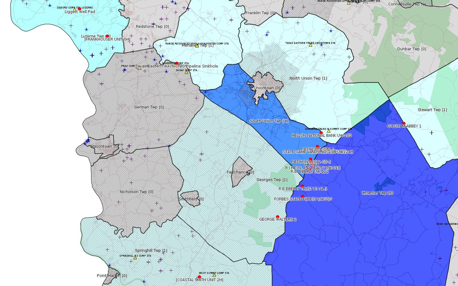
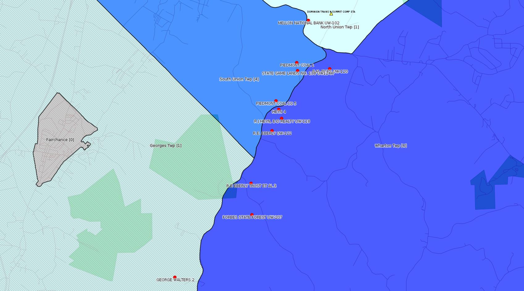
Click the map to enlarge
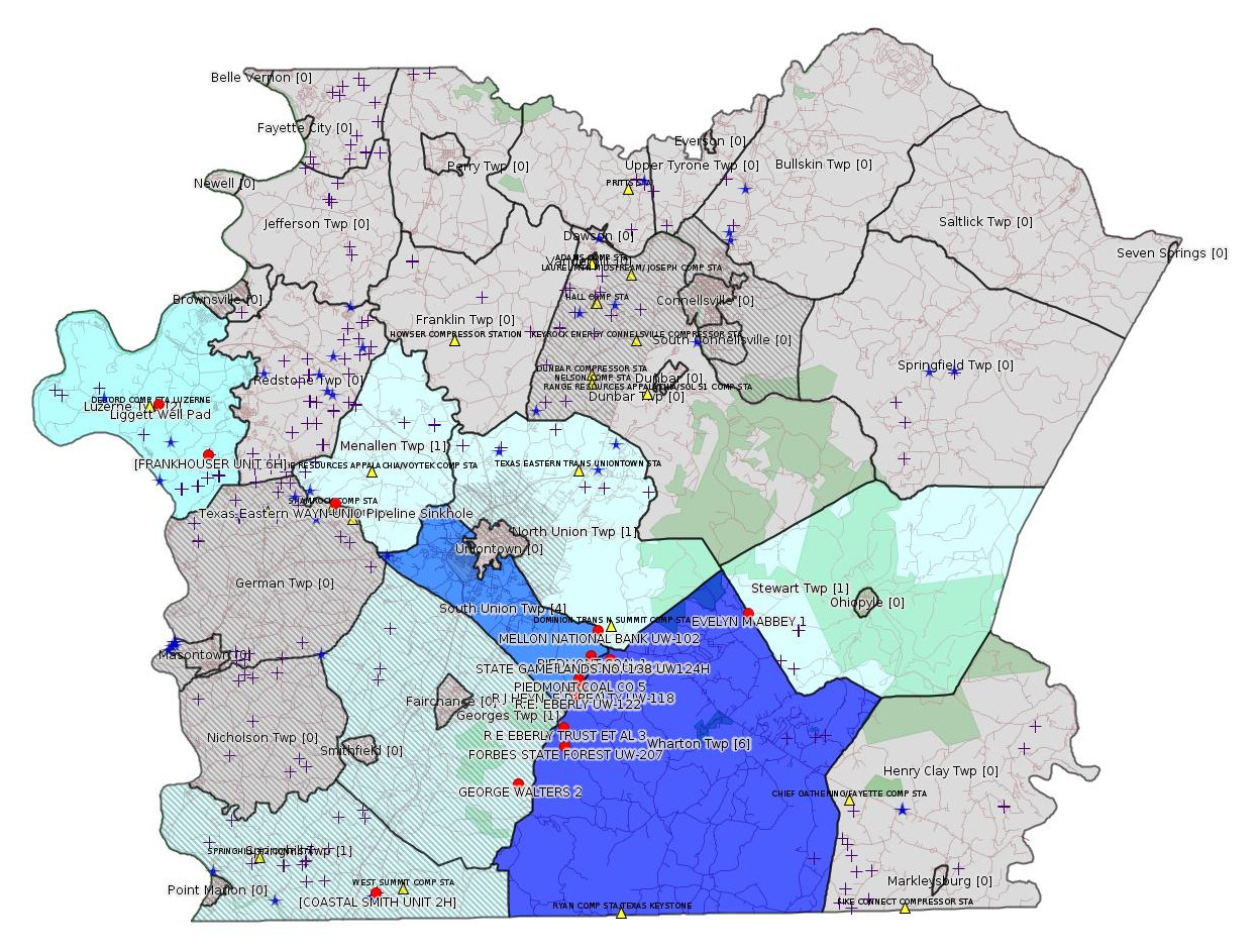
Map
Key
Red dots: items in this permit list with an exact location.
Blue stars: Marcellus Gas Well Water Sources.
Municipality shading: number of "facilities", with each well counting separately
(includes the red dots):
Red dots: items in this permit list with an exact location.
Blue stars: Marcellus Gas Well Water Sources.
Municipality shading: number of "facilities", with each well counting separately
(includes the red dots):
gray: 0
pale turquoise: 1
turquoise: 2
pale blue: 3
middle blue: 4
dark blue: 6
dark purple: 11
purple: 19
(Color coding may differ from one issue to the next.)
(Note if a project spans multiple municipalities -- e.g. a pipeline -- it will show in the count for each municipality.)
The number of facilities also follows the municipality name in brackets.
Municipality counts are based on the way the permit is listed by DEP; DEP has been known to get a municipality wrong.
Locations in brackets identify a precise location used to locate a surrogate for the actual site being permitted (e.g. locating a well pad or pipeline by the known location of a well.) Locations labeled beginning with "~" and ending in "[?]" are approximate and speculative based on inferences using on-line property and lease records. These are marked in the text as "[Approximate, Speculative]
Cross-hatching: Environmental Justice Areas
Yellow triangles: Compressor Stations
Crosses: Unconventional well permits (may not have been drilled)
Green: "Natural areas", e.g. state game lands, state forests
Yellow triangles: Compressor Stations
Crosses: Unconventional well permits (may not have been drilled)
Green: "Natural areas", e.g. state game lands, state forests
More Maps
 |
 |
 |
Source: Pennsylvania Bulletin
NOTICES
Governor's Pipeline Infrastructure Task Force Draft Final Report; Extension of Public Comment Period
[45 Pa.B. 7064]
[Saturday, December 12, 2015]
The public comment period for the Governor's Pipeline Infrastructure Task Force Draft Final Report (Report) is extended by 15 days. The Department of Environmental Protection (Department) will now be accepting comments through Tuesday, December 29, 2015.
On July 7, 2015, Governor Tom Wolf announced the 48 members of the Pipeline Infrastructure Task Force (Task Force), informed by 12 different workgroups. The workgroups met over the course of 3 months and developed recommendations for pipeline development with a focus on:
• Agriculture
• Conservation and Natural Resources
• County Government
• Emergency Preparedness
• Environmental Protection
• Historical/Cultural/Tribal Impacts
• Local Government
• Natural Gas End Use
• Pipeline Safety and Integrity
• Public Participation
• Siting and Routing
• Workforce and Economic Development
The recommendations developed by the workgroups will be reported to the Task Force for additional discussion, consideration and assimilation into the Report that will be presented to Governor Tom Wolf in February 2016.
A. Public Comments
The Department is accepting comments on the Report through December 29, 2015.
Comments submitted by facsimile will not be accepted. Comments, including comments submitted by e-mail, must include the originator's name and address. Commentators are encouraged to submit comments using the Department's online eComment tool at www.ahs.dep.pa.gov/eComment. Written comments should be submitted to the Department of Environmental Protection, Policy Office, Rachel Carson State Office Building, P. O. Box 2063, Harrisburg, PA 17105-2063, ecomment@pa.gov.
B. Contact
Questions concerning the comment period and report can be directed to the Task Force at RA-EPPITF@pa.gov. The draft report is available on the Department's web site at www.dep.pa.gov (DEP Keyword: Pipeline Infrastructure Task Force).
Persons in need of accommodations as provided for in the Americans with Disabilities Act of 1990 should contact the Department at (717) 783-8727 or through the Pennsylvania AT&T Relay Service at (800) 654-5984 (TDD users), or (800) 654-5988 (voice users) to discuss how the Department may accommodate their needs.
JOHN QUIGLEY,
Secretary
<http://www.pabulletin.com/secure/data/vol45/45-50/2181.html>
The draft report is available here:
<http://files.dep.state.pa.us/ProgramIntegration/PITF/Meetings/11-18-15/Governor's%20Pipeline%20Infrastructure%20Task%20Force%20DRAFT%20Report.pdf>
ESCGP-2 No.: ESX15-051-0008
Applicant Name: Liggett Well Pad
Contact Person: Alex Genovese
Address: 800 Mountain View Drive
City: Smithfield
State: PA Zip Code: 15478
County: Fayette Township(s): Luzerne
Receiving Stream(s) and Classifications: Rush Run, Tributary 40253 to Rush Run; Other Warm Water Fisheries (WWF)
<http://www.pabulletin.com/secure/data/vol45/45-50/2178d.html>
Location: 39.96845,-79.932322 <http://osm.org/go/ZWpZwKGq--?m=>
-------------------------
Source: eNOTICE (+ PA Oil and Gas Mapping)
[Conventional Well:]
Authorization ID: 1098234
Permit number: 051-20121
Site: EVELYN M ABBEY 1 WELL
Client: XTO ENERGY INC
Authorization type: Well Plugging Notice Intent to Plug Single Well
Application type: New
Authorization is for: FACILITY
Date received: 11/12/2015
Status: Pending
Sub-Facility ID Sub-Facility Name Description
56301 EVELYN M ABBEY 1 Well
<http://www.ahs.dep.pa.gov/eFACTSWeb/searchResults_singleAuth.aspx?AuthID=1098234>
Location: 39.864484,-79.567599 <http://osm.org/go/ZWptjg2X--?m=>
Municipalities, Stewart Twp
Authorization ID: 1086550
Permit number: ESX10-051-0019
Site: FRANKHOUSER WELL SITES ESCGP-EXPEDITED
Client: ATLAS RESOURCES LLC
Authorization type: Expedited E&S Stormwater General Permit 1
Application type: Notification
Authorization is for: SITE
Date received: 08/24/2015
Status: Denied on 12/10/2015
<http://www.ahs.dep.pa.gov/eFACTSWeb/searchResults_singleAuth.aspx?AuthID=1086550>
Location [of FRANKHOUSER UNIT 6H (surrogate)]: 39.944183,-79.901542 <http://osm.org/go/ZWpY~Sft--?m=>
Municipalities: Luzerne Twp
Authorization ID: 1100685
Permit number: ESX10-051-0035
Site: COASTAL 1H FLOW BACK PIT FRESHWATER PITS ESCGP-EXPEDITED
Client: BURNETT OIL CO INC
Authorization type: Expedited E&S Stormwater General Permit 1
Application type: Amendment
Authorization is for: SITE
Date received: 12/08/2015
Status: Pending
<http://www.ahs.dep.pa.gov/eFACTSWeb/searchResults_singleAuth.aspx?AuthID=1100685>
Location [of COASTAL SMITH UNIT 2H]: 39.733371,-79.80094 <http://osm.org/go/ZWpgBJ3s--?m=>
Municipalities: Springhill Twp [an Environmental Justice Area]
-------------------------
Source: DEP Oil and Gas Compliance Report
[All the listings in this section are conventional wells. See Notes.]
OPERATOR: DOMINION TRANS INC
INSPECTION_ID: 2428718
INSPECTION_DATE: 11/24/2015
INSPECTION_TYPE: Routine/Complete Inspection
API_PERMIT: 051-00098
FARM_NAME: MELLON NATIONAL BANK UW-102
UNCONVENTIONAL: N
SITE_ID: 40776
SITE_NAME: MELLON NATL BANK UW-102 WELL
FACILITY_TYPE: Oil & Gas Location
INSPECTION_CATEGORY: Primary Facility
REGION: EP DOGO SWDO Dstr Off
COUNTY: Fayette
MUNICIPALITY: North Union Twp
INSPECTION_RESULT_DESCRIPTION: No Violations Noted
INSPECTION_COMMENT: 3113 psig; storage well; Valves B& C leaking;
Location: 39.857507,-79.661052 <http://osm.org/go/ZWpm3Uxy--?m=>
OPERATOR: DOMINION TRANS INC
INSPECTION_ID: 2428729
INSPECTION_DATE: 11/24/2015
INSPECTION_TYPE: Routine/Complete Inspection
API_PERMIT: 051-00115
FARM_NAME: PIEDMONT COAL 1
UNCONVENTIONAL: N
SITE_ID: 40793
SITE_NAME: PIEDMONT COAL 1 WELL
FACILITY_TYPE: Oil & Gas Location
INSPECTION_CATEGORY: Primary Facility
REGION: EP DOGO SWDO Dstr Off
COUNTY: Fayette
MUNICIPALITY: South Union Twp
INSPECTION_RESULT_DESCRIPTION: No Violations Noted
INSPECTION_COMMENT: 3095 psig; biocide treatment 2014; leaking valves A,B, C
Location: 39.845509,-79.665533 <http://osm.org/go/ZWpmxzLu--?m=>
OPERATOR: DOMINION TRANS INC
INSPECTION_ID: 2428730
INSPECTION_DATE: 11/24/2015
INSPECTION_TYPE: Routine/Complete Inspection
API_PERMIT: 051-20544
FARM_NAME: PIEDMONT COAL UW-109
UNCONVENTIONAL: N
SITE_ID: 41442
SITE_NAME: PIEDMONT COAL UW-109 WELL
FACILITY_TYPE: Oil & Gas Location
INSPECTION_CATEGORY: Primary Facility
REGION: EP DOGO SWDO Dstr Off
COUNTY: Fayette
MUNICIPALITY: South Union Twp
INSPECTION_RESULT_DESCRIPTION: No Violations Noted
INSPECTION_COMMENT: 3081 psig; valve packing issues on Valves B,C,D;
[BOGUS -jr] Location: 39.948829,-79.919986
[See Notes.]
OPERATOR: DOMINION TRANS INC
INSPECTION_ID: 2428739
INSPECTION_DATE: 11/24/2015
INSPECTION_TYPE: Routine/Complete Inspection
API_PERMIT: 051-20056
FARM_NAME: R.H. RICKS UW-120
UNCONVENTIONAL: N
SITE_ID: 40981
SITE_NAME: RH RICKS UW-120 WELL
FACILITY_TYPE: Oil & Gas Location
INSPECTION_CATEGORY: Primary Facility
REGION: EP DOGO SWDO Dstr Off
COUNTY: Fayette
MUNICIPALITY: Wharton Twp
INSPECTION_RESULT_DESCRIPTION: No Violations Noted
INSPECTION_COMMENT: 4474psig in the Tuscawaras formation; well does not measure Oriskany pressures; plug and abandon.
Location: 39.843591,-79.653423 <http://osm.org/go/ZWpmzsHH--?m=>
OPERATOR: DOMINION TRANS INC
INSPECTION_ID: 2428746
INSPECTION_DATE: 11/24/2015
INSPECTION_TYPE: Routine/Complete Inspection
API_PERMIT: 051-20815
FARM_NAME: STATE GAME LANDS NO. 138 UW124H
UNCONVENTIONAL: N
SITE_ID: 41710
SITE_NAME: SGL 138 UW124H WELL
FACILITY_TYPE: Oil & Gas Location
INSPECTION_CATEGORY: Primary Facility
REGION: EP DOGO SWDO Dstr Off
COUNTY: Fayette
MUNICIPALITY: South Union Twp
INSPECTION_RESULT_DESCRIPTION: No Violations Noted
INSPECTION_COMMENT: 3092 psig; D valve was replaced; A valve has leak issues; replaced??
Location: 39.843182,-79.66528 <http://osm.org/go/ZWpmxjz7--?m=>
OPERATOR: DOMINION TRANS INC
INSPECTION_ID: 2428758
INSPECTION_DATE: 11/24/2015
INSPECTION_TYPE: Routine/Complete Inspection
API_PERMIT: 051-20949
FARM_NAME: FORBES STATE FOREST UW-207
UNCONVENTIONAL: N
SITE_ID: 465818
SITE_NAME: FORBES STATE FOREST UW-207 OG WELL
FACILITY_TYPE: Oil & Gas Location
INSPECTION_CATEGORY: Primary Facility
REGION: EP DOGO SWDO Dstr Off
COUNTY: Fayette
MUNICIPALITY: Wharton Twp
INSPECTION_RESULT_DESCRIPTION: No Violations Noted
INSPECTION_COMMENT: 3079 psig; Valve A has stem/packing issues;
Location: 39.80234,-79.682891 <http://osm.org/go/ZWpjbUj5-?m=>
OPERATOR: DOMINION TRANS INC
INSPECTION_ID: 2428764
INSPECTION_DATE: 11/24/2015
INSPECTION_TYPE: Routine/Complete Inspection
API_PERMIT: 051-24409
FARM_NAME: R E EBERLY TRUST ET AL 3
UNCONVENTIONAL: N
SITE_ID: 741884
SITE_NAME: R E EBERLY TRUST ET AL 3 OG WELL
FACILITY_TYPE: Oil & Gas Location
INSPECTION_CATEGORY: Primary Facility
REGION: EP DOGO SWDO Dstr Off
COUNTY: Fayette
MUNICIPALITY: Wharton Twp
INSPECTION_RESULT_DESCRIPTION: No Violations Noted
INSPECTION_COMMENT: 3065 psig; coil tubing clean out in 2015; B valve has issues; leaking;
Location: 39.811311,-79.683064 <http://osm.org/go/ZWpjfFj~--?m=>
OPERATOR: DOMINION TRANS INC
INSPECTION_ID: 2432106
INSPECTION_DATE: 12/10/2015
INSPECTION_TYPE: Routine/Complete Inspection
API_PERMIT: 051-00113
FARM_NAME: PIEDMONT COAL CO 5
UNCONVENTIONAL: N
SITE_ID: 40791
SITE_NAME: PIEDMONT COAL 5 OG WELL
FACILITY_TYPE: Oil & Gas Location
INSPECTION_CATEGORY: Primary Facility
REGION: EP DOGO SWDO Dstr Off
COUNTY: Fayette
MUNICIPALITY: South Union Twp
INSPECTION_RESULT_DESCRIPTION: No Violations Noted
INSPECTION_COMMENT: 2916 psig; storage; annular flow 2390 cf/day; annular vent kicking gas with noise of fluid.; need direct connection to barrel for any fluid that may be discharged; need to find source of annular gas; now an indicator well;
Location: 39.834672,-79.673456 <http://osm.org/go/ZWpmP7nv--?m=>
OPERATOR: DOMINION TRANS INC
INSPECTION_ID: 2432110
INSPECTION_DATE: 12/10/2015
INSPECTION_TYPE: Routine/Complete Inspection
API_PERMIT: 051-00092
FARM_NAME: HEYN 4
UNCONVENTIONAL: N
SITE_ID: 40770
SITE_NAME: HEYN 4 WELL
FACILITY_TYPE: Oil & Gas Location
INSPECTION_CATEGORY: Primary Facility
REGION: EP DOGO SWDO Dstr Off
COUNTY: Fayette
MUNICIPALITY: Wharton Twp
INSPECTION_RESULT_DESCRIPTION: No Violations Noted
INSPECTION_COMMENT: storage welll; 2860 psig; withdrawing; valves tight to turn; annular flow 52cf/day
Location: 39.832262,-79.672477 <http://osm.org/go/ZWpmlBa7--?m=>
OPERATOR: DOMINION TRANS INC
INSPECTION_ID: 2432112
INSPECTION_DATE: 12/10/2015
INSPECTION_TYPE: Routine/Complete Inspection
API_PERMIT: 051-20538
FARM_NAME: R J HEYN, E-D REALTY UW-118
UNCONVENTIONAL: N
SITE_ID: 41436
SITE_NAME: RJ HEYN E D REALTY UW-118 OG WELL
FACILITY_TYPE: Oil & Gas Location
INSPECTION_CATEGORY: Primary Facility
REGION: EP DOGO SWDO Dstr Off
COUNTY: Fayette
MUNICIPALITY: Wharton Twp
INSPECTION_RESULT_DESCRIPTION: No Violations Noted
INSPECTION_COMMENT: 2875 psig; C valve leaking & grinding; withdrawing;
Location: 39.829654,-79.671408 <http://osm.org/go/ZWpmkWDq--?m=>
OPERATOR: DOMINION TRANS INC
INSPECTION_ID: 2432115
INSPECTION_DATE: 12/10/2015
INSPECTION_TYPE: Routine/Complete Inspection
API_PERMIT: 051-20540
FARM_NAME: R.E. EBERLY UW-122
UNCONVENTIONAL: N
SITE_ID: 41438
SITE_NAME: RE EBERLY UW-122 WELL
FACILITY_TYPE: Oil & Gas Location
INSPECTION_CATEGORY: Primary Facility
REGION: EP DOGO SWDO Dstr Off
COUNTY: Fayette
MUNICIPALITY: Wharton Twp
INSPECTION_RESULT_DESCRIPTION: No Violations Noted
INSPECTION_COMMENT: 2859 psig; packing leaks on all valves;
Location: 39.826195,-79.675057 <http://osm.org/go/ZWpmOoeq--?m=>
OPERATOR: DOMINION TRANS INC
INSPECTION_ID: 2432120
INSPECTION_DATE: 12/10/2015
INSPECTION_TYPE: Routine/Complete Inspection
API_PERMIT: 051-00116
FARM_NAME: GEORGE WALTERS 2
UNCONVENTIONAL: N
SITE_ID: 40794
SITE_NAME: GEORGE WALTERS 2 WELL
FACILITY_TYPE: Oil & Gas Location
INSPECTION_CATEGORY: Primary Facility
REGION: EP DOGO SWDO Dstr Off
COUNTY: Fayette
MUNICIPALITY: Georges Twp
INSPECTION_RESULT_DESCRIPTION: No Violations Noted
INSPECTION_COMMENT: observation well; cannot inspect; legal issues to enter land; need to P&A 3 notice;
Location: 39.784831,-79.71165 <http://osm.org/go/ZWpjEa27--?m=>
-------------------------
Source: me, area residents
Incident report to PHMSA, (Pipeline and Hazardous Material Safety Agency):
Approximate Location: Latitude: 39.92, Longitude: -79.82327
NPMS metadata for the suspected pipeline:
OPERATOR ID: 19235
OPERATOR NAME: TEXAS EASTERN TRANSMISSION LP (SPECTRA ENERGY CORP)
SYSTEM NAME: WAYN-UNIO
COMMODITY CATEGORY: Natural Gas
COMMODITY DESCRIPTION: NATURAL GAS
INTERSTATE DESIGNATION: Y
PIPELINE STATUS CODE: In Service
GENERAL PERSON TO CONTACT: Dwayne Teschendorf(Principal Engineer)
GENERAL ENTITY TO CONTACT
GENERAL ADDRESS: 5400 Westheimer Ct,Null, Houston TX 77056
GENERAL PHONE/FAX/EMAIL: Phone: (713) 627-5573 Null Fax: Null Email: none
Notes:
Please find two attachments. The first attachment shows an NPMS screen
shot. The small dot inside the red circle gives the *approximate* location
of the suspected problem; the second attachment shows a Google Maps
satellite image, and again the suspected problem is located approximately
in the red circle.
The problem is *two sinkholes*, one of which is exposing a pipeline, which
I believe is identified above. I have not been to the site myself, but have
spoken by phone to a nearby resident who has; he reports that the sinkholes
are approximately 50 feet south of New Salem Road, "between the road and
the swamp". "Someone" is apparently aware of the problem, since a warning
fence has been placed around the sinkholes. The nearby resident believes
the gas in the pipeline has been turned off, so there is no imminent
emergency. However the concern is obviously that the sinkholes could grow.
Our area has been subject to extensive coal mining, and in many places
older residents can recall hearing stories from their older family memebers
about undocumented coal mines. This may or may not have anything to do with
the sinkholes.
In the satellite image, the facility in the lower left corner is Shamrock
Compressor Station, which is owned and operated by Laurel Mountain
Midstream. Please note that this compressor station, while as large (in
horsepower) as some compressor stations along transmission lines, is *NOT*
a FERC-regulated facility; it serves as a major hub for gathering lines in
this area of the Marcellus Shale.
Approximate Location 39.92,-79.82327 <http://osm.org/go/ZWpatJPu--?m=>
Municipality: Menallen Twp
[See Notes.]
-------------------------
Source: Reuters Commodities: Energy
Natural Gas
| Commodity | Exchange | Currency | Expire | Last Trade | Trade Time | Change | Open | Day's High | Day's Low |
|---|---|---|---|---|---|---|---|---|---|
| NATURAL
GAS CON1 Dec15 |
NYM | USD | 12/29 | 1.90 | 12/13 21:19 | +0.01 | 1.90 | 1.90 | 1.90 |
-------------------------
Notes:
The well PIEDMONT COAL UW-109 shown in an inspection report above is listed in DEP records as South Union Twp, but the latitude and longitude listed in DEP records are clearly in Luzerne Twp. I am guessing the twp listing is correct and the lat/long are bogus. Because of this problem, this entry is not mapped.
The leaks reported for Dominion wells above are in conventional wells, but this is a reminder that many of the problems we have been concerned about regarding Marcellus Shale are also problems of conventional wells that perhaps we didn't pay proper attention to until the onset of Marcellus Shale drilling. Any kind of leak is a concern from the point of view of climate change, since methane is a potent greenhouse gas.
Sinkholes have opened up near Shamrock Compressor Station, at least one of which is exposing an interstate Texas Eastern natural gas transmission line. Interstate transmission lines are regulated federally, by PHMSA, Pipeline and Hazardous Materials Safety Agency. PHMSA maintains a web site for mapping federally regulated pipelines called NPMS, National Pipeline Mapping System. The NPMS map viewer is available here:
<https://www.npms.phmsa.dot.gov/PublicViewer/composite.jsf>
(Note: If you drill down far enough on the NPMS viewer, the pipelines disappear from the map. High-detail pipeline maps are considered security-related restricted information.) The NPMS screen shot referred to in the incident report above is shown as the "More Maps" entry far right, above.
------------------------
DEP defines an environmental justice area as "any census tract where 20 percent or more individuals live in poverty, and/or 30 percent or more of the population is minority". (See:
<http://www.portal.state.pa.us/portal/server.pt/community/pa_environmental_justice_areas/20991>
<http://www.portal.state.pa.us/portal/server.pt/community/dep_enhanced_public_participation_policy/20988>
). There are supposed to be enhanced public participation requirements for permits in environmental justice areas, but news of this actually ever happening is scarce. In Fayette County, the entirety of Springhill, Nicholson, German, and Georges Townships are environmental justice areas, as well as a large part of Dunbar Township. DEP's policy document on public participation guidelines for environmental justice areas is located here:
<http://www.elibrary.dep.state.pa.us/dsweb/Get/Version-48671/012-0501-002.pdf>
eNOTICE records are likely to list the same permit multiple times, as that permit moves through the DEP process.
Oil & Gas Wells designated with a site a number and the letter H typically designate horizontal wells.
-------------------------
Resources:
Pennsylvania Bulletin: <http://www.pabulletin.com/>
eNOTICE: <http://www.ahs2.dep.state.pa.
DEP Well Details Report: <https://www.paoilandgasreport
Well Details may not show any
information for new permits and will not show permits which have
not yet been issued. Lookup for Well Details is by permit number.
DEP Permits Issued Detail Report:
<http://www.depreportingservic
DEP SPUD (drilling started) Report:
<http://www.depreportingservices.state.pa.us/ReportServer/Pages/ReportViewer.aspx?/Oil_Gas/Spud_External_Data>
DEP Oil and Gas Compliance Report:
<http://www.depreportingservices.state.pa.us/ReportServer/Pages/ReportViewer.aspx?/Oil_Gas/OG_Compliance>
DEP PA Oil & Gas Mapping:
<http://www.depgis.state.pa.us/PaOilAndGasMapping>
Pennsylvania Spatial Data Access:
<http://www.pasda.psu.edu/default.asp>
DEP Spatial Data Repository:
<ftp://www.pasda.psu.edu/pub/pasda/dep/>
National Response Center:
<http://www.nrc.uscg.mil/>
EPA-Echo: <http://www.epa-echo.gov/echo/
FERC citizen involvement: <http://www.ferc.gov/for-citiz
To receive E-mail notification of
all documents filed in a FERC docket, see:
<http://www.ferc.gov/docs-filing/esubscription.asp >
<http://www.ferc.gov/docs-fili
Follow the directions and enter the docket number to subscribe to.
Township Supervisors receive information regarding Erosion & Sedimentation permits, and these records may be reviewable at township municipal offices.
DEP permits are reviewable through the File Review process, for application to do file review see: <http://www.portal.state.pa.us/portal/server.pt/community/southwest_regional_office/13775/file_review/593164>
Environmental Hearing Board: <http://ehb.courtapps.com/publ
PA DEP Environmental Policy Comment System:
<http://www.ahs.dep.pa.gov/eComment/>
Federal Register Environment: <https://www.federalregister.g
Browsing of recent comment
opportunities for federal agencies, e.g. EPA. Click "sign up" to
subscribe to daily E-mails of new document listings.
SkyTruth Fayette County Drilling Alerts: <http://frack.skytruth.org/pen
EPA Pennsylvania Public Notices: <http://www2.epa.gov/aboutepa/epa-pennsylvania#notice>
Marcellus Shale waste disposal
injection wells in Pennsylvania are regulated directly by EPA, not
DEP. Notice of any new permit applications will appear at the
above web address. I'm not aware of any subscription service
to be notified of such applications. I'm not aware of any
Marcellus Shale waste disposal injection wells in Fayette County
(yet ...) but we need to monitor this page for future
applications.
Energy Assurance Daily: <http://www.oe.netl.doe.gov/ead.aspx>
Daily newsletter from the US
Department of Energy about events relating to energy. The Natural
Gas section has information about pipelines.
-------------------------
Disclaimers:
This compilation from the above sources was done by hand using copy and paste and may omit relevant permits.
Does not currently include water supply permits. Does not include landfill permits even though many such are for Marcellus Shale waste. (It is not possible at this time to distinguish which landfill permits are for Marcellus Shale waste and which are not without doing File Review for each permit.)
Erosion & Sedimentation permit records do not currently include latitude and longitude. Where I am publishing latitude and longitude with E&S permits it is by inferring an associated well permit and using published latitude and longitude for the well. It is possible I may be inferring the wrong well site.
Municipalities are shown from eFACTS records on the DEP web site. The DEP has been known to list a municipality incorrectly.