The Harmed Success Stories Concepts How To What Is Commentary
Fayette County Marcellus Shale Permits 7/25/16 - 8/7/16
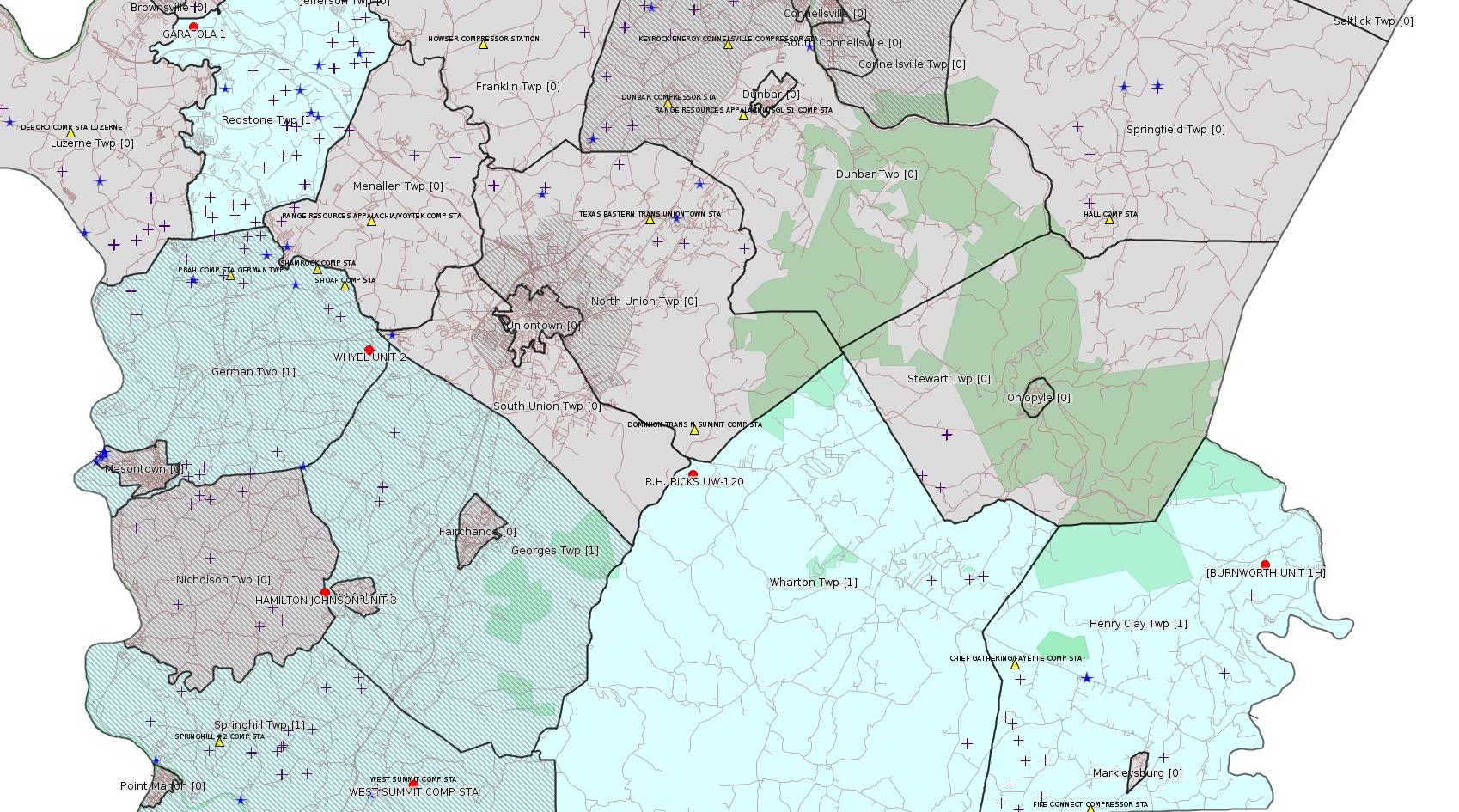
Click the map to enlarge
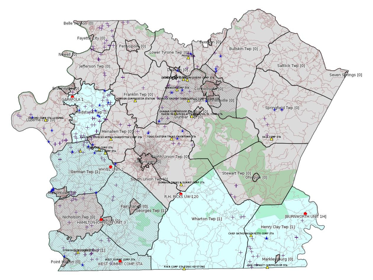
Map
Key
Red dots: items in this permit list with an exact location.
Blue stars: Marcellus Gas Well Water Sources.
Municipality shading: number of "facilities", with each well counting separately
(includes the red dots):
Red dots: items in this permit list with an exact location.
Blue stars: Marcellus Gas Well Water Sources.
Municipality shading: number of "facilities", with each well counting separately
(includes the red dots):
gray: 0
pale turquoise: 1
turquoise: 2
pale blue: 3
middle blue: 4
dark blue: 6
dark purple: 11
purple: 19
(Color coding may differ from one issue to the next.)
(Note if a project spans multiple municipalities -- e.g. a pipeline -- it will show in the count for each municipality.)
The number of facilities also follows the municipality name in brackets.
Municipality counts are based on the way the permit is listed by DEP; DEP has been known to get a municipality wrong.
Locations in brackets identify a precise location used to locate a surrogate for the actual site being permitted (e.g. locating a well pad or pipeline by the known location of a well.) Locations labeled beginning with "~" and ending in "[?]" are approximate and speculative based on inferences using on-line property and lease records. These are marked in the text as "[Approximate, Speculative]
Cross-hatching: Environmental Justice Areas
Yellow triangles: Compressor Stations
Crosses: Unconventional well permits (may not have been drilled)
Green: "Natural areas", e.g. state game lands, state forests
Yellow triangles: Compressor Stations
Crosses: Unconventional well permits (may not have been drilled)
Green: "Natural areas", e.g. state game lands, state forests
More Maps
 |
Source: Pennsylvania Bulletin
NOTICES
2016 Draft Integrated Water Quality Monitoring and Assessment Report; Availability for Public Comment
[46 Pa.B. 4264]
[Saturday, July 30, 2016]
The Department of Environmental Protection (Department) is providing for public comment its draft 2016 Integrated Water Quality Monitoring and Assessment Report (Integrated Report). The Integrated Report includes both a narrative description of the Commonwealth's water quality management programs (formerly the Federal Clean Water Act section 305(b) Report) and waterbody-specific lists depicting the status of Commonwealth surface waters as required by section 303(d) of the Federal Clean Water Act (33 U.S.C.A. § 1313(d)).
Section 303(d) of the Federal Clean Water Act and 40 CFR Part 130 (relating to water quality planning and management) require states to identify waters which would be impaired, even after the appropriate pollution control technology has been applied to point sources and required best management practices are in place for nonpoint sources. The Integrated Report establishes five categories for listing waterbodies. Waterbodies that do not meet water quality standards and that require a Total Maximum Daily Load (TMDL) are placed on Category 5 of the Integrated Report waterbody list.
For each waterbody in Category 5, the Commonwealth or, if requested, the United States Environmental Protection Agency (EPA) must develop TMDL allocations. A TMDL is a calculation of the assimilative capacity of a waterbody to handle point and nonpoint pollutant loads without violating water quality standards. TMDLs also describe the conditions necessary to improve water quality. TMDLs are used to set limits in National Pollution Discharge Elimination System water quality permits and identify pollutant load reductions for nonpoint sources necessary to improve and protect water quality. When a TMDL is approved by the EPA for a waterbody, that waterbody listing is removed from Category 5 and placed in Category 4a.
In addition to comments of a general nature on the Integrated Report, the Department is seeking comment on the eight waters listed as high priorities for TMDL development and the 16 waters selected to be restored through alternatives to TMDLs. These waters can be found on page 27 of the report. Descriptions of the waterbodies, causes of impairment and reason for selection are included.
Waterbody assessment and compilation of the Integrated Report is an ongoing process. The Department will continue to verify the quality of data used in this process and, as needed, will publish supplements to the Integrated Report for public review and comment.
The draft 2016 Integrated Report is available on the Department's web site at www.ahs.dep.pa.gov/eComment.
The Department invites public comments on the draft Integrated Report and will accept comments through Monday, September 12, 2016. Comments submitted by facsimile will not be accepted. Comments, including comments submitted by e-mail, must include the originator's name and address. Commentators are urged to submit comments using the Department's online eComment system at www.ahs.dep.pa.gov/eComment. Written comments should be submitted by e-mail to ecomment@pa.gov or by mail to the Department of Environmental Protection, Policy Office, Rachel Carson State Office Building, P.O. Box 2063, Harrisburg, PA 17105-2063.
Persons in need of accommodations as provided for in the Americans with Disabilities Act of 1990 should contact Gary Walters at (717) 787-9637 or through the Pennsylvania AT&T Relay Service at (800) 654-5984 (TTD) to discuss how the Department may accommodate their needs.
PATRICK McDONNELL,
Acting Secretary
<http://www.pabulletin.com/secure/data/vol46/46-31/1315.html>
-------------------------
Source: eNOTICE (+ PA Oil and Gas Mapping) Please see the Disclaimer below regarding Parcel Id data.
Authorization ID: 1085677
Permit number: ESX10-051-0028
Site: BURNWORTH FRESHWATER IMPOUNDMENT ESCGP-EXPEDITED
Client: CHIEF OIL & GAS LLC
Authorization type: Expedited E&S Stormwater General Permit 1
Application type: Notification
Authorization is for: SITE
Date received: 08/13/2015
Status: Withdrawn on 7/20/2016
<http://www.ahs.dep.pa.gov/eFACTSWeb/searchResults_singleAuth.aspx?AuthID=1085677>
Location [of BURNWORTH UNIT 1H]: 39.808139,-79.390917 <http://osm.org/go/ZWrB22cP--?m=>
Municipalities: Henry Clay Twp
Presumed Parcel ID: 16090033
Authorization ID: 1145684
Permit number: GP5-26-00589B
Site: WEST SUMMIT COMP STA
Client: BURNETT OIL CO INC
Authorization type: AQ General Permit
Application type: New
Authorization is for: FACILITY
Date received: 07/12/2016
Status: Pending
<http://www.ahs.dep.pa.gov/eFACTSWeb/searchResults_singleAuth.aspx?AuthID=1145684>
Location: 39.734998,-79.784172 <http://osm.org/go/ZWpgD4uk--?m=>
Municipalities: Springhill Twp [an Environmental Justice Area]
Presumed Parcel Id: 36210048
[See Notes.]
Authorization ID: 1142397
Permit number: 051-21230
Site: GARAFOLA 1 OG WELL
Client: KEYROCK ENERGY LLC
Authorization type: Well Plugging Notice Intent to Plug Single Well
Application type: New
Authorization is for: FACILITY
Date received: 05/09/2016
Status: Pending
Sub-Facility ID Sub-Facility Name Description
533284 GARAFOLA 1 Well
<http://www.ahs.dep.pa.gov/eFACTSWeb/searchResults_singleAuth.aspx?AuthID=1142397>
Location: 40.004581,-79.880819 <http://osm.org/go/ZWpeGQ1h--?m=>
Municipalities: Redstone Twp
Presumed Parcel Id: 30040220
[Conventional Well]
Authorization ID: 1146843
Permit number: 051-23376
Site: HAMILTON-JOHNSON UNIT 3 OG WELL
Client: RANGE RESOURCES APPALACHIA LLC
Authorization type: Well Plugging Notice Intent to Plug Single Well
Application type: New
Authorization is for: FACILITY
Date received: 07/25/2016
Status: Pending
Sub-Facility ID Sub-Facility Name Description
926831 HAMILTON-JOHNSON UNIT 3 Well
<http://www.ahs.dep.pa.gov/eFACTSWeb/searchResults_singleAuth.aspx?AuthID=1146843>
Location: 39.803583,-79.823429 <http://osm.org/go/ZWpL8IK_--?m=>
Municipalities: Georges Twp [an Environmental Justice Area]
Presumed Parcel Id: 14240076
[See Notes.]
Authorization ID: 1146844
Permit number: 051-23376
Site: HAMILTON-JOHNSON UNIT 3 OG WELL
Client: RANGE RESOURCES APPALACHIA LLC
Authorization type: Well Plugging Notice Alternate Method
Application type: New
Authorization is for: FACILITY
Date received: 07/25/2016
Status: Pending
Sub-Facility ID Sub-Facility Name Description
926831 HAMILTON-JOHNSON UNIT 3 Well
<http://www.ahs.dep.pa.gov/eFACTSWeb/searchResults_singleAuth.aspx?AuthID=1146844>
Authorization ID: 1146884
Permit number: 051-24582
Site: WHYEL UNIT PREVIOUSLY SUMEY 1H ESCGP-EXPEDITED
Client: BURNETT OIL CO INC
Authorization type: Drill & Operate Well Permit
Application type: Renewal
Authorization is for: FACILITY
Date received: 06/30/2016
Status: Pending
<http://www.ahs.dep.pa.gov/eFACTSWeb/searchResults_singleAuth.aspx?AuthID=1146884>
Location: 39.889344,-79.80168 <http://osm.org/go/ZWplRYcV--?m=>
Municipalities: German Twp [an Environmental Justice Area]
Presumed Parcel Id: 15290036
Previous Renewal Full Permit:
<http://www.depgis.state.pa.us/pdfHandler/pdFHandler.ashx?Doc=MjEzMTM3&ext=PDF>
Farm Name: WHYEL UNIT 2
Conservation Well: Y
Unconventional Well: N
Well Configuration: Vertical Well
Anticipated Maximum TVD: 8359 feet
[See Notes.]
-------------------------
Source: Oil & Gas Compliance Report:
[Conventional Well]:
OPERATOR: DOMINION TRANS INC
INSPECTION_ID: 2506437
INSPECTION_DATE: 07/28/2016
INSPECTION_TYPE: Plugging(Includes Plugged/Mined Through)
API_PERMIT: 051-20056
FARM_NAME: R.H. RICKS UW-120
UNCONVENTIONAL: N
SITE_ID: 40981
SITE_NAME: RH RICKS UW-120 WELL
FACILITY_TYPE: Oil & Gas Location
INSPECTION_CATEGORY: Primary Facility
REGION: EP DOGO SWDO Dstr Off
COUNTY: Fayette
MUNICIPALITY: Wharton Twp
INSPECTOR: KUHNS, SUSAN
INSPECTION_RESULT_DESCRIPTION: No Violations Noted
INSPECTION_COMMENT: Preparing to plug old Tuscarora well in the North Summit storage field; Cement bond log indicates Top of cement in 4 1/2' casing @ 6800' which is up into the 7" casing that is not cemented to surface; Plug set above Tuscarora at 11,350'; Location is covered with hard pads; E&S in place; Access road is in good shape with no E&S issues.
Location: 39.843591,-79.653423 <http://osm.org/go/ZWpmzsHH--?m=>
Presumed Parcel Id: 4205009701
[See Notes.]
-------------------------
Source: Reuters Commodities: Energy
Natural Gas
| Commodity | Exchange | Currency | Expire | Last Trade | Trade Time | Change | Open | Day's High | Day's Low |
|---|---|---|---|---|---|---|---|---|---|
| NATURAL
GAS CON1 Aug16 |
NYM | USD | 08/29 | 2.74 | 08/06 22:59 | -0.04 | 2.75 | 2.75 | 2.73 |
-------------------------
Notes:
The current permit for the Burnett Oil West Summit Compressor Station is GP5-26-00589A, issued on 8/18/2011, which means it is about to expire. The current application is not of type renewal, so we don't know if they intend any new equipment for this location. The current authorization record for this facility shows the following equipment:
1025054 CATERPILLAR G3516B NATURAL GAS-FIRED COMPRESSOR ENGINE #1 Process
1025055 CATERPILLAR G3516B NATURAL GAS-FIRED COMPRESSOR ENGINE #2 Process
1025056 CATERPILLAR G3516B NATURAL GAS-FIRED COMPRESSOR ENGINE #3 Process
1025058 CATERPILLAR G3516B NATURAL GAS-FIRED COMPRESSOR ENGINE #4 Process
1025059 CATERPILLAR G3516B NATURAL GAS-FIRED COMPRESSOR ENGINE #5 Process
1025060 CATERPILLAR G3516B NATURAL GAS-FIRED COMPRESSOR ENGINE #6 Process
1049059 FUGITIVES Process
1049057 GLYCOL DEHYS UNIT 2 Process
The 6 engines shown are rated at 1380 bhp; it is not clear whether they are equipped with oxidation catalysts or not.
---
According to the Well Details Report, the Hamilton-Johnson Unit 3 well was never in production.
---
This is the second renewal for Whyel Unit 2. It is a Marcellus vertical well, apparently described as a "conventional well" to reduce the amount of the impact fee under Act 13. Oil & Gas Mapping shows the metadata below for the previous renewal; there is a discrepancy in Issuance Date between this metadata and eFACTS. The eFACTS record for authorization 1078660 shows as issued on 8/4/2015.
Permit Number: 051-24582
Well Name: WHYEL UNIT 2
Operator: BURNETT OIL CO INC
Operator Number: OGO-39119
Well Type: GAS
Storage Field Name:
Well Status: Proposed But Never Materialized
Original Permit Issuance Date: 7/18/2013
Permit Expiration Date: 7/18/2016
SPUD Date:
Date Plugged:
Conservation Well: Y
County: Fayette
Municipality: German Twp
Latitude DD: 39.889344
Longitude DD: -79.80168
Latitude DMS: 39° 53' 21.6384''
Longitude DMS: -79° 48' 6.048''
Primary Facility ID 765753
Unconventional Well: N
Surface Elevation: 1290
Well Configuration: Vertical Well
Coal: NonCoal
Well Pad Name - ID: -
UIC ID:
UIC Type Description:
Site ID: 749115
Site Name: WHYEL UNIT PREVIOUSLY SUMEY 1H ESCGP-EXPEDITED
---
The well RH RICKS UW-120 was listed in inspection reports carried in the 12/13/15 issue of this bulletin as one of a large number of wells in the Dominion Transmission North Summit Storage Field with anomalies of various kinds, including leaking valves and pressure anomalies, One assumes DEP carried out these inspections in the wake of the massive Porter Ranch storage field leak near Los Angeles to make sure there was no serious leak from the North Summit field, which is currently the only FERC-listed Jurisdictional Storage Field in Fayette County. The specific prior report for
RH RICKS UW-120 shows:
OPERATOR: DOMINION TRANS INC
INSPECTION_ID: 2428739
INSPECTION_DATE: 11/24/2015
INSPECTION_TYPE: Routine/Complete Inspection
API_PERMIT: 051-20056
FARM_NAME: R.H. RICKS UW-120
UNCONVENTIONAL: N
SITE_ID: 40981
SITE_NAME: RH RICKS UW-120 WELL
FACILITY_TYPE: Oil & Gas Location
INSPECTION_CATEGORY: Primary Facility
REGION: EP DOGO SWDO Dstr Off
COUNTY: Fayette
MUNICIPALITY: Wharton Twp
INSPECTION_RESULT_DESCRIPTION: No Violations Noted
INSPECTION_COMMENT: 4474psig in the Tuscawaras formation; well does not measure Oriskany pressures; plug and abandon.
------------------------
DEP defines an environmental justice area as "any census tract where 20 percent or more individuals live in poverty, and/or 30 percent or more of the population is minority". (See:
<http://www.portal.state.pa.us/portal/server.pt/community/pa_environmental_justice_areas/20991>
<http://www.portal.state.pa.us/portal/server.pt/community/dep_enhanced_public_participation_policy/20988>
). There are supposed to be enhanced public participation requirements for permits in environmental justice areas, but news of this actually ever happening is scarce. In Fayette County, the entirety of Springhill, Nicholson, German, and Georges Townships are environmental justice areas, as well as a large part of Dunbar Township. DEP's policy document on public participation guidelines for environmental justice areas is located here:
<http://www.elibrary.dep.state.pa.us/dsweb/Get/Version-48671/012-0501-002.pdf>
eNOTICE records are likely to list the same permit multiple times, as that permit moves through the DEP process.
Oil & Gas Wells designated with a site a number and the letter H typically designate horizontal wells.
-------------------------
Resources:
Pennsylvania Bulletin: <http://www.pabulletin.com/>
eNOTICE: <http://www.ahs2.dep.state.pa.
DEP Well Details Report: <https://www.paoilandgasreport
Well Details may not show any
information for new permits and will not show permits which have
not yet been issued. Lookup for Well Details is by permit number.
DEP Permits Issued Detail Report:
<http://www.depreportingservic
DEP SPUD (drilling started) Report:
<http://www.depreportingservices.state.pa.us/ReportServer/Pages/ReportViewer.aspx?/Oil_Gas/Spud_External_Data>
DEP Oil and Gas Compliance Report:
<http://www.depreportingservices.state.pa.us/ReportServer/Pages/ReportViewer.aspx?/Oil_Gas/OG_Compliance>
DEP PA Oil & Gas Mapping:
<http://www.depgis.state.pa.us/PaOilAndGasMapping>
Fayette County Assessment Office Search For Tax Records:
<http://property.co.fayette.pa.us/search.aspx>
Pennsylvania Spatial Data Access:
<http://www.pasda.psu.edu/default.asp>
DEP Spatial Data Repository:
<ftp://www.pasda.psu.edu/pub/pasda/dep/>
National Response Center:
<http://www.nrc.uscg.mil/>
EPA-Echo: <http://www.epa-echo.gov/echo/
FERC citizen involvement: <http://www.ferc.gov/for-citiz
To receive E-mail notification of
all documents filed in a FERC docket, see:
<http://www.ferc.gov/docs-filing/esubscription.asp >
<http://www.ferc.gov/docs-fili
Follow the directions and enter the docket number to subscribe to.
Township Supervisors receive information regarding Erosion & Sedimentation permits, and these records may be reviewable at township municipal offices.
DEP permits are reviewable through the File Review process, for application to do file review see: <http://www.portal.state.pa.us/portal/server.pt/community/southwest_regional_office/13775/file_review/593164>
Environmental Hearing Board: <http://ehb.courtapps.com/publ
PA DEP Environmental Policy Comment System:
<http://www.ahs.dep.pa.gov/eComment/>
Federal Register Environment: <https://www.federalregister.g
Browsing of recent comment
opportunities for federal agencies, e.g. EPA. Click "sign up" to
subscribe to daily E-mails of new document listings.
SkyTruth Fayette County Drilling Alerts: <http://frack.skytruth.org/pen
EPA Pennsylvania Public Notices: <http://www2.epa.gov/aboutepa/epa-pennsylvania#notice>
Marcellus Shale waste disposal
injection wells in Pennsylvania are regulated directly by EPA, not
DEP. Notice of any new permit applications will appear at the
above web address. I'm not aware of any subscription service
to be notified of such applications. I'm not aware of any
Marcellus Shale waste disposal injection wells in Fayette County
(yet ...) but we need to monitor this page for future
applications.
Energy Assurance Daily: <http://www.oe.netl.doe.gov/ead.aspx>
Daily newsletter from the US
Department of Energy about events relating to energy. The Natural
Gas section has information about pipelines.
-------------------------
Disclaimers:
This compilation from the above sources was done by hand using copy and paste and may omit relevant permits.
Parcel data is provided via the tax records search web page offered by the Fayette County Assessment Office (http://property.co.fayette.pa.us/). Presumed Parcel Id links are subject to availability provided by that agency and associated web sites. Presumed Parcel Ids are determined as the mapped parcel containing a given latitude and longitude, are a best effort determination which is subject to error, and are not official. In cases where a facility is leased and there is a separate parcel id for the lease, if this parcel id is not separately mapped, the parcel id shown will be the id for the enclosing parcel. Parcel owners may be surface owners only and may or may not have any relationship to oil & gas facilities.
Does not currently include water supply permits. Does not include landfill permits even though many such are for Marcellus Shale waste. (It is not possible at this time to distinguish which landfill permits are for Marcellus Shale waste and which are not without doing File Review for each permit.)
Erosion & Sedimentation permit records do not currently include latitude and longitude. Where I am publishing latitude and longitude with E&S permits it is by inferring an associated well permit and using published latitude and longitude for the well. It is possible I may be inferring the wrong well site.
Municipalities are shown from eFACTS records on the DEP web site. The DEP has been known to list a municipality incorrectly.