The Harmed Success Stories Concepts How To What Is Commentary
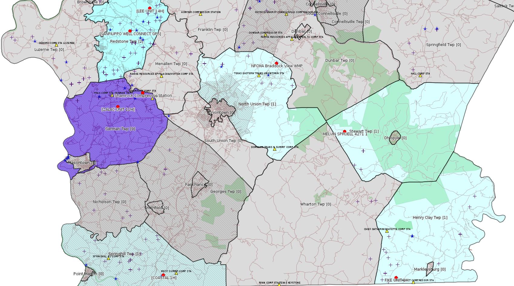
Fayette County Marcellus Shale Permits 8/22/16 - 9/4/16
Click the map to enlarge
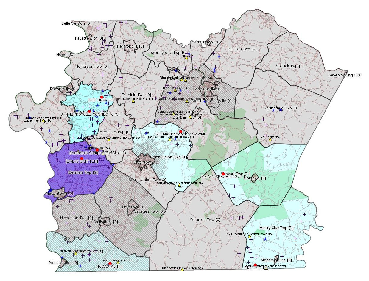
Map
Key
Red dots: items in this permit list with an exact location.
Blue stars: Marcellus Gas Well Water Sources.
Municipality shading: number of "facilities", with each well counting separately
(includes the red dots):
Red dots: items in this permit list with an exact location.
Blue stars: Marcellus Gas Well Water Sources.
Municipality shading: number of "facilities", with each well counting separately
(includes the red dots):
gray: 0
pale turquoise: 1
turquoise: 2
pale blue: 3
middle blue: 4
dark blue: 6
dark purple: 11
purple: 19
(Color coding may differ from one issue to the next.)
(Note if a project spans multiple municipalities -- e.g. a pipeline -- it will show in the count for each municipality.)
The number of facilities also follows the municipality name in brackets.
Municipality counts are based on the way the permit is listed by DEP; DEP has been known to get a municipality wrong.
Locations in brackets identify a precise location used to locate a surrogate for the actual site being permitted (e.g. locating a well pad or pipeline by the known location of a well.) Locations labeled beginning with "~" and ending in "[?]" are approximate and speculative based on inferences using on-line property and lease records. These are marked in the text as "[Approximate, Speculative]
Cross-hatching: Environmental Justice Areas
Yellow triangles: Compressor Stations
Crosses: Unconventional well permits (may not have been drilled)
Green: "Natural areas", e.g. state game lands, state forests
Yellow triangles: Compressor Stations
Crosses: Unconventional well permits (may not have been drilled)
Green: "Natural areas", e.g. state game lands, state forests
More Maps
 |
Source: Pennsylvania Bulletin
[No Activity]
-------------------------
Source: eNOTICE (+ PA Oil and Gas Mapping) Please see the Disclaimer below regarding Parcel Id data.
Authorization ID: 1148977
Permit number: ESX14-051-0017
Site: SANFILIPPO WELL CONNECT PROJECT ESCGP-2 EXPEDITED
Client: LAUREL MTN MIDSTREAM OPR LLC
Authorization type: Expedited E&S Stormwater General Permit 1
Application type: Notification
Authorization is for: SITE
Date received: 08/22/2016
Status: Pending
<http://www.ahs.dep.pa.gov/eFACTSWeb/searchResults_singleAuth.aspx?AuthID=1148977>
Location [of SANFILIPPO WELL CONNECT GP5 (surrogate)]: 39.981039,-79.840847 <http://osm.org/go/ZWpb0myc--?m=>
Municipalities: Redstone Twp
Presumed Parcel Id: 30190154
[See Notes.]
Authorization ID: 1149027
Permit number: ESX11-051-0031
Site: LEE WELL SITE ESCGP-EXPEDITED
Client: CHEVRON APPALACHIA LLC
Authorization type: Expedited E&S Stormwater General Permit 1
Application type: Notification
Authorization is for: SITE
Date received: 08/22/2016
Status: Pending
<http://www.ahs.dep.pa.gov/eFACTSWeb/searchResults_singleAuth.aspx?AuthID=1149027>
Location [of LEE UNIT 14H (surrogate)]: 40.003889,-79.814303 <http://osm.org/go/ZWpeuF~q--?m=>
Municipalities: Redstone Twp
Presumed Parcel Id: 30060201
Authorization ID: 1149059
Permit number: 051-24164
Site: FIKE UNIT 1H OG WELL
Client: LPR ENERGY LLC
Authorization type: Drill & Operate Well Permit Inactive Status
Application type: New
Authorization is for: FACILITY
Date received: 06/23/2016
Status: Pending
Sub-Facility ID Sub-Facility Name Description
983871 FIKE UNIT 1H Well
<http://www.ahs.dep.pa.gov/eFACTSWeb/searchResults_singleAuth.aspx?AuthID=1149059>
Location: 39.727028,-79.495752 <http://osm.org/go/ZWpqgA7n--?m=>
Municipalities: Henry Clay Twp
Presumed Parcel Id: 16190003
[See Notes.]
[Conventional Well:]
Authorization ID: 1149427
Permit number: 051-20022
Site: MELVIN SPRUELL 4271 1 OG WELL
Client: XTO ENERGY INC
Authorization type: Well Plugging Notice Intent to Plug Single Well
Application type: New
Authorization is for: FACILITY
Date received: 08/25/2016
Status: Pending
Sub-Facility ID Sub-Facility Name Description
56229 MELVIN SPRUELL 4271 1 Well
<http://www.ahs.dep.pa.gov/eFACTSWeb/searchResults_singleAuth.aspx?AuthID=1149427>
Location: 39.876056,-79.560111 <http://osm.org/go/ZWpttJR5--?m=>
Presumed Parcel Id: 37100001
Municipalities: Stewart Twp
Authorization ID: 1096925
Permit number: ESX15-051-0012
Site: COASTAL CENTRAL WELL PAD ESCGP-2 EXPEDITED
Client: BURNETT OIL CO INC
Authorization type: Expedited E&S Stormwater General Permit 1
Application type: New
Authorization is for: SITE
Date received: 11/12/2015
Status: Pending
<http://www.ahs.dep.pa.gov/eFACTSWeb/searchResults_singleAuth.aspx?AuthID=1096925>
Location [approximate, speculative] [of COASTAL 1H]: 39.733294,-79.801028 <http://osm.org/go/ZWpgBJ2N--?m=>
Municipalities: Springhill Twp [an Environmental Justice Area]
Presumed Parcel Id: 36210048
Authorization ID: 1150005
Permit number: 26-00588
Site: SHAMROCK COMP STA
Client: LAUREL MTN MIDSTREAM OPR LLC
Authorization type: Minor Facility Plan Approval New Source Performance Std
Application type: Extension
Authorization is for: FACILITY
Date received: 08/26/2016
Status: Pending
<http://www.ahs.dep.pa.gov/eFACTSWeb/searchResults_singleAuth.aspx?AuthID=1150005>
Location: 39.918333,-79.825 <http://osm.org/go/ZWpasXGm--?m=>
Municipalities: German Twp [an Environmental Justice Area]
Parcel ID: 15140026
Authorization ID: 1150015
Permit number: 26-00588A
Site: SHAMROCK COMP STA
Client: LAUREL MTN MIDSTREAM OPR LLC
Authorization type: Major Facility Plan Approval New Facility Review Prevention of Significant Deterioration
Application type: Extension
Authorization is for: FACILITY
Date received: 08/26/2016
Status: Pending
<http://www.ahs.dep.pa.gov/eFACTSWeb/searchResults_singleAuth.aspx?AuthID=1150015>
-------------------------
Source: DEP Oil and Gas Compliance Report
OPERATOR: CHEVRON APPALACHIA LLC
INSPECTION_ID: 2513899
INSPECTION_DATE: 08/26/2016
INSPECTION_TYPE: Drilling/Alteration
API_PERMIT: 051-24627
FARM_NAME: ZALAC UNIT 11H
UNCONVENTIONAL: Y
SITE_ID: 786409
SITE_NAME: ZALAC UNIT #5-11H WELL SITE ESCGP-2 EXPEDITED
FACILITY_TYPE: Oil & Gas Location
INSPECTION_CATEGORY: Primary Facility
REGION: EP DOGO SWDO Dstr Off
COUNTY: Fayette
MUNICIPALITY: German Twp [an Environmental Justice Area]
INSPECTOR: LEWIS, RICHARD
INSPECTION_RESULT_DESCRIPTION: No Violations Noted
INSPECTION_COMMENT: HORIZONTAL MARCELLUS, Prepairing site for fracing operation starting in 2-weeks.
[There is a similar report for Zalac Units 5H-10H].
Location: 39.904589,-79.858089 <http://osm.org/go/ZWpaKHEr--?m=>
Presumed Parcel Id: 15110064
[See Notes.]
-------------------------
Source: Fayette County Office of Planning, Zoning, and Community Development
[Repeat listing, with more information:]
From the July 14, 2016 Planning Commission Meeting Agenda Project Reviews:
Tetra Tech, Inc. submitting intent to apply to DEP for a water management plan for the withdrawal of water associated with oil & gas exploration from the North Fayette County Municipal Authority Meter Vault on Braddock View Drive, North Union Township.
From the Notification: "Tetra Tech, Inc. (Tetra Tech) is submitting this notification letter on behalf of Chevron Appalachia, LLC (Chevron), who intends to submit to the Pennsylvania Department of Environmental Protection a Water Management Plan for the withdrawal of water for use in oil and gas exploration activities."
Location: 39.946228,-79.648435 <http://osm.org/go/ZWpy9X9Y--?m=>
The full notification document is available here:
<http://faymarwatch.org/documents/SKM_554e16082310450.pdf>
[See Notes.]
-------------------------
Source: Reuters Commodities: Energy
Natural Gas
| Commodity | Exchange | Currency | Expire | Last Trade | Trade Time | Change | Open | Day's High | Day's Low |
|---|---|---|---|---|---|---|---|---|---|
| NATURAL
GAS CON1 Sep16 |
NYM | USD | 09/28 | 2.76 | 09/04 22:08 | -0.04 | 2.76 | 2.77 | 2.73 |
<http://www.reuters.com/finance/commodities/energy>
-------------------------
Notes:
The SANFILIPPO WELL CONNECT PROJECT is evidently a pipeline from the Sanfilippo well pads (there are two well pads in close proximity) south to a Laurel Mountain Midstream pipeline on one of the Jackson (as in Jackson Farms) properties. The location shown is on the Sanfilippo property; the permit above is an Erosion & Sedimentation permit for the entire pipeline.
---
FIKE UNIT 1H was originally permitted to Chief Oil & Gas in 2009. The Chief leases in "the mountains" of Fayette County were subsequently bought out by Chevron; Chevron evidently does not intend to produce gas from these leases. LPR Energy LLC is a Dallas TX company which has evidently taken over several older Marcellus wells in Fayette County. This is the first listing for them in this bulletin. This well was first permitted for Inactive Status on 5/24/2012.
---
Word of imminent fracking at the Zalac well site from the Oil & Gas Compliance Report is really interesting. I know of no reliable way to know from available DEP data where fracking is about to occur or is occurring.
Some of the wells at Zalac have received permits for Alt Method of Equipping, Casing, or Venting Well due to interaction with a coal mine. For details see the 5/17/15 issue of this bulletin. For the full permit for Zalac 7H, see:
<http://www.depgis.state.pa.us/pdfHandler/pdFHandler.ashx?Doc=MjAxNzI1&ext=PDF>
---
The "Tetra Tech" Water Management Plan (WMP) item from the July Fayette County Planning Commission agenda appears to be the same facility already listed in the Marcellus Gas Well Water Sources data set and shown in the maps for this bulletin as blue stars. This entry has the following metadata in the PASDA WMP data set:
SF_NAME: NORTH FAYETTE WATER AUTH SOURCE 24 INTC
PF_NAME: CHEVRON APPALACHIA LLC
FAC_TYPE_D: Interconnection
FAC_DESC: Buying Interconnection
PEAK_DAILY: 2.0
MAX_RATE: 2000.0
AVG_DAILY: 0.0
PASSBY_REQ: N
PASSBY_AMT: 0.0
APPR_DATE: Thu Dec 15 00:00:00 EST 2011
EXP_DATE: Thu Dec 15 00:00:00 EST 2016
REG_OFFICE: SWRO
CNTY_NAME: Fayette
MUNI_NAME: North Union
WMP_ID: 2799865.0
ORG_WMP_ID:
WUDS_PWSID: 19147.0
WUDS_SFID: 63149.0
WUDS_PFID: 62289.0
It is not clear what the zoning is here, it may be light industrial, but this facility may need a Special Exception for Public / Private Works from the Zoning Hearing Board anyway. It is not clear what the correct parcel number is here; it may be 25160381, which is listed on the Fayette County Property Search web site as the location of a Western PA Water Co. pumping station.
Applications for Water Management Plans are not considered permits by DEP and do not get authorization records in eFACTS.
------------------------
DEP defines an environmental justice area as "any census tract where 20 percent or more individuals live in poverty, and/or 30 percent or more of the population is minority". (See:
<http://www.portal.state.pa.us/portal/server.pt/community/pa_environmental_justice_areas/20991>
<http://www.portal.state.pa.us/portal/server.pt/community/dep_enhanced_public_participation_policy/20988>
). There are supposed to be enhanced public participation requirements for permits in environmental justice areas, but news of this actually ever happening is scarce. In Fayette County, the entirety of Springhill, Nicholson, German, and Georges Townships are environmental justice areas, as well as a large part of Dunbar Township. DEP's policy document on public participation guidelines for environmental justice areas is located here:
<http://www.elibrary.dep.state.pa.us/dsweb/Get/Version-48671/012-0501-002.pdf>
eNOTICE records are likely to list the same permit multiple times, as that permit moves through the DEP process.
Oil & Gas Wells designated with a site a number and the letter H typically designate horizontal wells.
-------------------------
Resources:
Pennsylvania Bulletin: <http://www.pabulletin.com/>
eNOTICE: <http://www.ahs2.dep.state.pa.
DEP Well Details Report: <https://www.paoilandgasreport
Well Details may not show any
information for new permits and will not show permits which have
not yet been issued. Lookup for Well Details is by permit number.
DEP Permits Issued Detail Report:
<http://www.depreportingservic
DEP SPUD (drilling started) Report:
<http://www.depreportingservices.state.pa.us/ReportServer/Pages/ReportViewer.aspx?/Oil_Gas/Spud_External_Data>
DEP Oil and Gas Compliance Report:
<http://www.depreportingservices.state.pa.us/ReportServer/Pages/ReportViewer.aspx?/Oil_Gas/OG_Compliance>
DEP PA Oil & Gas Mapping:
<http://www.depgis.state.pa.us/PaOilAndGasMapping>
Fayette County Assessment Office Search For Tax Records:
<http://property.co.fayette.pa.us/search.aspx>
Pennsylvania Spatial Data Access:
<http://www.pasda.psu.edu/default.asp>
DEP Spatial Data Repository:
<ftp://www.pasda.psu.edu/pub/pasda/dep/>
National Response Center:
<http://www.nrc.uscg.mil/>
EPA-Echo: <http://www.epa-echo.gov/echo/
FERC citizen involvement: <http://www.ferc.gov/for-citiz
To receive E-mail notification of
all documents filed in a FERC docket, see:
<http://www.ferc.gov/docs-filing/esubscription.asp >
<http://www.ferc.gov/docs-fili
Follow the directions and enter the docket number to subscribe to.
Township Supervisors receive information regarding Erosion & Sedimentation permits, and these records may be reviewable at township municipal offices.
DEP permits are reviewable through the File Review process, for application to do file review see: <http://www.portal.state.pa.us/portal/server.pt/community/southwest_regional_office/13775/file_review/593164>
Environmental Hearing Board: <http://ehb.courtapps.com/publ
PA DEP Environmental Policy Comment System:
<http://www.ahs.dep.pa.gov/eComment/>
Federal Register Environment: <https://www.federalregister.g
Browsing of recent comment
opportunities for federal agencies, e.g. EPA. Click "sign up" to
subscribe to daily E-mails of new document listings.
SkyTruth Fayette County Drilling Alerts: <http://frack.skytruth.org/pen
EPA Pennsylvania Public Notices: <http://www2.epa.gov/aboutepa/epa-pennsylvania#notice>
Marcellus Shale waste disposal
injection wells in Pennsylvania are regulated directly by EPA, not
DEP. Notice of any new permit applications will appear at the
above web address. I'm not aware of any subscription service
to be notified of such applications. I'm not aware of any
Marcellus Shale waste disposal injection wells in Fayette County
(yet ...) but we need to monitor this page for future
applications.
Energy Assurance Daily: <http://www.oe.netl.doe.gov/ead.aspx>
Daily newsletter from the US
Department of Energy about events relating to energy. The Natural
Gas section has information about pipelines.
-------------------------
Disclaimers:
This compilation from the above sources was done by hand using copy and paste and may omit relevant permits.
Parcel data is provided via the tax records search web page offered by the Fayette County Assessment Office (http://property.co.fayette.pa.us/). Presumed Parcel Id links are subject to availability provided by that agency and associated web sites. Presumed Parcel Ids are determined as the mapped parcel containing a given latitude and longitude, are a best effort determination which is subject to error, and are not official. In cases where a facility is leased and there is a separate parcel id for the lease, if this parcel id is not separately mapped, the parcel id shown will be the id for the enclosing parcel. Parcel owners may be surface owners only and may or may not have any relationship to oil & gas facilities.
Does not currently include water supply permits. Does not include landfill permits even though many such are for Marcellus Shale waste. (It is not possible at this time to distinguish which landfill permits are for Marcellus Shale waste and which are not without doing File Review for each permit.)
Erosion & Sedimentation permit records do not currently include latitude and longitude. Where I am publishing latitude and longitude with E&S permits it is by inferring an associated well permit and using published latitude and longitude for the well. It is possible I may be inferring the wrong well site.
Municipalities are shown from eFACTS records on the DEP web site. The DEP has been known to list a municipality incorrectly.